Mt. Baldy

CB Avalanche Center2020-21 Observations

Zone: Northwest Mountains

Location: East face

Date of Observation: 12/03/2020

Name: Alan Bernholtz


Subject: Mt. Baldy

Aspect: East

Elevation: 12,400

Avalanches:

No avalanches were served but we did get a few collapses in isolated wind deposited snow on the approach. Very specific terrain features


Weather: Clear, cool, and moderate west winds on the summit

Snowpack: Variety of snow surfaces and depth. We experienced all kinds of snow conditions (except deep powder). At he deepest point the couloir held around 70 cm of snow but again, was a wide variety of depths. There was wind loaded areas and wind stripped areas. We found a few distinct crusts. A sun crust lower in the pack and wind board closer to the upper end of the pack and the surface was stiff from wind and sun. (Sounds horrible right but it was too bad) There were facets sitting on the ground, could possibly have been depth hoar but we did get too into checking it out but it felt well developed.
Mid mountain was scalloped shallow snowpack with near surface facets forming. The low revelation we found melt freeze supportable on south aspect. Yes, we hit rocks too.
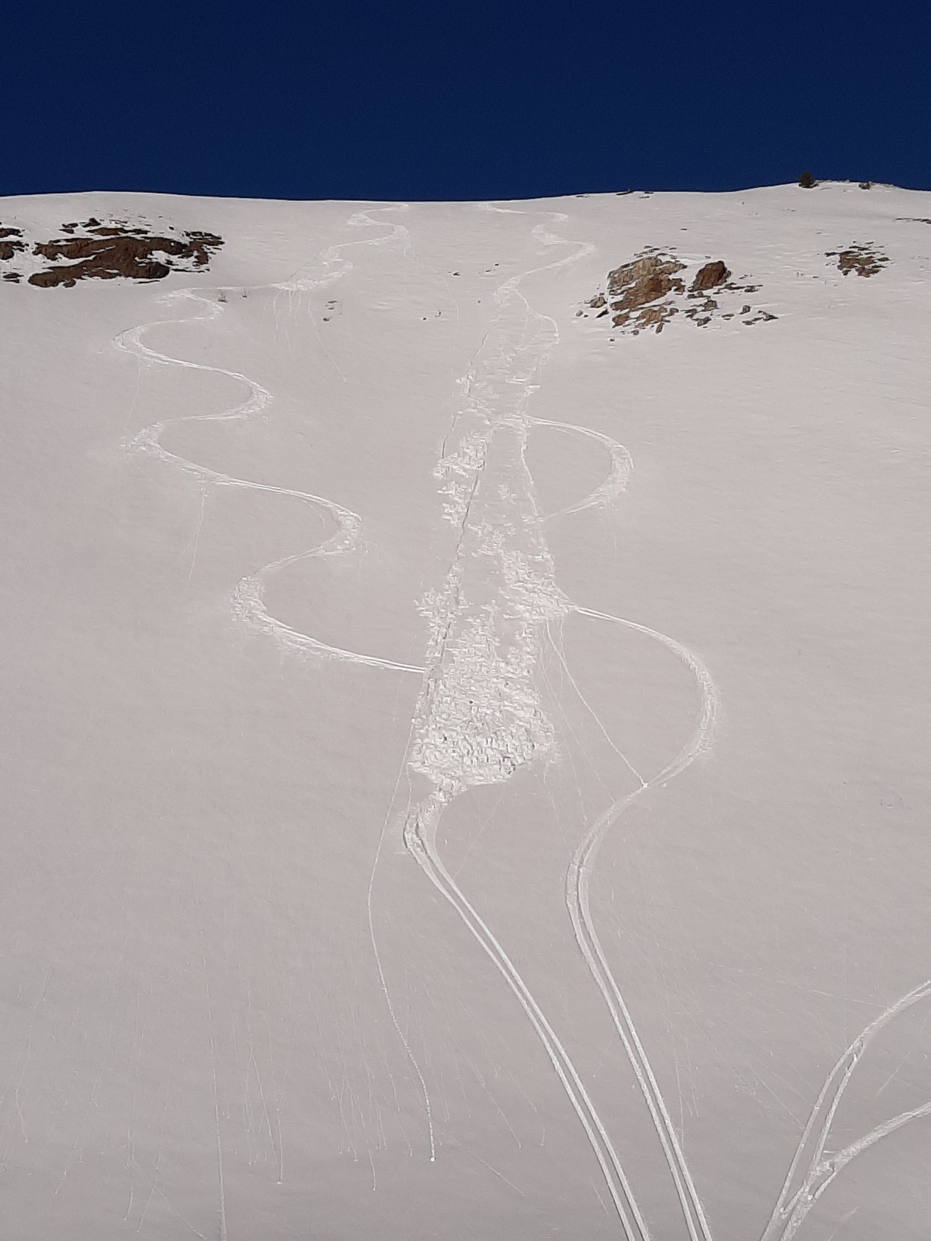
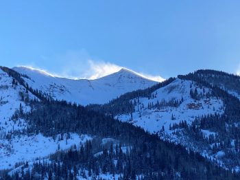
Photos:


Mount Axtel Weak Snow Junk Show

CB Avalanche Center2020-21 Observations

Zone: Northwest Mountains

Location: Mount Axtel

Date of Observation: 12/02/2020

Name: Eric Murrow


Subject: Mount Axtel Weak Snow Junk Show

Aspect: North, North East, East

Elevation: 9,500′ – 11,900′

Avalanches:

Intentionally triggered a couple small Dry Loose avalanches on north and east slopes near and below treeline. Loose dry avalanches did not fan out and spread, and entrained little mass, just enough to knock you over.


Weather: Cool day with light winds and some mellow gusts. Did not observe any significant transport of the couple inches of new from the previous day.

Snowpack: A weak and shallow mess. Snowpack ranged from 30 to 60 cm through this terrain. Areas less than about 45cm had little to no support to skis. Areas with 50cm or more still have snow at 4 finger hardness which provided a meager amount of support to skis. On all slopes traveled with open view to the sky there was buried, standing surface hoar, 6 – 10mm in size, underneath the few inches of new snow from the day previous.

East facing slopes were 1 -1.5mm facets that were fist hard with a faceting/decomposing crust in the middle. Small loose dry avalanches were easily initiated but were not quite able to gouge through the crust in the middle of the snowpack. Weakest snow observed was on east slopes just below the surface, 1.5mm solid facets.

Northerly slopes were well faceted, but generally a bit smaller grain size than east, ~1mm. We were able to easily initiated small Loose dry avalanches, but they did not gouge to the ground in most places.

Shaded near and below treeline terrain in this area is not functional for recreating. Depth of snow cover dictated snowpack support not elevation. There was a clear small Loose Dry avalanche problem, but the biggest threat to safety is attempting to ride through this shallow mess.

Photos:


Snodgrass study pit

CB Avalanche Center2020-21 Observations

Zone: Southeast Mountains

Location: E facing knoll on Snodgrass

Date of Observation: 11/26/2020

Name: Jack Caprio

Subject: Snodgrass

Aspect: East

Elevation: 10,000

Avalanches: None observed

Weather: Scattered clouds, sun coming in and out. Temps around 20’s. Light winds less than 10 mph out of the south.

Snowpack: I tested the snowpack on an east facing aspect below treeline. I found thin melt freeze crust at depths of 20 cm and 15 cm with F hard facets above and below. Sitting on the bottom of the pack are 15 cm of 1-1.5 mm facets

No exciting propagating results in stability tests. However, both the fractures on CT and ECT collapsed on the interface of old faceted snow and the melt freeze crust at 15cm. This weak layer crust has the potential to initiate, but it is unlikely to propagate.

Photos:


NE powder SW sun crusts

CB Avalanche Center2020-21 Observations

Zone: Northwest Mountains

Location: Poverty Gulch

Date of Observation: 11/28/2020

Name: Travis Colbert


Subject: NE powder SW sun crusts

Aspect: North East, South West

Elevation: 9,200-11,600

Avalanches:

Very slow moving sloughs (top 20cm) on 36-38 shaded slopes. Very slow moving shallow slough/slab (10cm sun crust) on 32-34 degree sunny slope.


Weather: Blue skies & very little wind. Single digits in the morning, warming to the lower 20s by afternoon.

Snowpack: HS 90-95cm on shaded NE slopes; upper 20cm unconsolidated new snow sitting on a soft crust. HS much lower (did not measure, but maybe 20cm) on sunny SW slopes; but compacted and supportable with 8-10cm soft sun on the surface.

Photos:

Slides on Snodgrass NE Lines

CB Avalanche Center2020-21 Observations

Zone: Southeast Mountains
Location: 2nd Bowl
Date of Observation: 11/26/2020

Subject: Slides on Snodgrass NE Lines
Aspect: North East
Elevation: ~11k

Avalanches: D1.5, hard slab, 18 inch crown, interface between facets at the ground and newer 4F stiffness snow:

Dropping into 2nd bowl to check out coverage, stayed on the rail skier’s Right. Suspect terrain evaluated before skiing was exactly what slide: small convex rollovers formed over rock shelves in the top 50 feet of the line. Used a ski cut on top of one of these terrain features to get the entirety of the snowpack–which was about 18 inches–to fracture. Ran about 500 feet, picking up lots of speed and snow. The crown broke and propagated over pretty obviously terrain features, stopping at the concave gut of the line.

We made another ski cut just to clear the remaining hangfire and got a smaller slide to go, running only about 200 and entraining much less snow. D1.

Weather: Slight flurries, alternating sun and high cloud cover, 25-30F, no wind.

Snowpack: Ranging from a few inches on South faces to 2.5 feet on NE lines, from the ridge down to Gothic Road. F-4F slab sitting on about an inch of 2-3mm facets.


Small sluffs and slabs at upper elevations from the past 48hr’s

CB Avalanche Center2020-21 Observations

Zone: Northwest Mountains
Location: Upper Crystal Watershed
Date of Observation: 11/25/2020
Name: Evan Ross

Subject: Small sluffs and slabs at upper elevations from the past 48hr’s
Aspect: North, East
Elevation: 11,000-12,000

Avalanches: Maybe 20’ish small avalanches at upper elevations, mostly releasing from wind-loading, but a couple coming out of rock bands. A few from today, others were slightly older. Mostly sluffs, or maybe small cornice chucks coming down. Few small crowns. There could have been more crowns that were either too small to see, or had blown back over. These avalanches were observed on west,  north and east aspects, with easterly having the most activity.

Weather: Clear, mild temps. Moderate ridgetop winds with light transport. Mostly calm conditions at lower elevations.

Snowpack: North 11-12,000ft: Skied a couple different laps and a couple different skin tracks. HS was generally in the 60 to 80cm range. We traveled on new snow over old wind-board, to a general 70cm snowpack over a thin layer of dry facets, and through many transitions from the supportive slab into shallow a less supportive snowpack. All and all the snowpack was mostly quiet outside of a couple of small collapses. Those collapses didn’t seem to collapse big parts of the slope. The layer of facets at the ground is fairly thin and maybe there was too much ground roughness.

Easterly 11-12,000ft: Great riding conditions on east with the new snow over a supportive snowpack. Tilt a little SE and the snow-surface was becoming moist. We climbed into the start-zone of an easterly bowl right below a ridge. Sections of the bowl were stripped of the new snow by NW winds. Other sections had more of a cross-loading pattern. We moved through a few thick cross-loaded drifts on 35-degree slopes. Those drifts were thick and not giving us any feedback to instability.

All and all, we found good stability and some lovely turns.

Also noticed several ski tracks of folks skiing some large bowls on the northerly side of Baldy, and on both easterly and northeasterly bowls off Purple Ridge. Looked like some folks got some good turns.


Sunpow

CB Avalanche Center2020-21 Observations

Zone: Northwest Mountains

Location: upper end of Slate River Valley

Date of Observation: 11/25/2020

Name: Than Acuff


Subject: Sunpow

Aspect: North East

Elevation: BTL to ATL

Avalanches:

None observed, new snow stuffing from below rocks on north aspect above treeline.


Weather: Sunny and temps ranged from single digits (morning in valley floor) to 30’s (1 p.m. valley floor).

Snowpack: There were spots where the snowpack had 7 inches new new on top of 20 inches of denser snow and no crusts on a more north aspect in the open but below treeline. Then, 50 feet further it was 7 inches on top of 20 inches of unconsolidated snow. And then, off the ridge top was 8 inches of new snow sitting on a firm crust on NE aspects and deeper pack, 30 inches total give or take. And small pockets of wind load off the ridgetop.
I am super psyched on the early bird raffle and virtual Awareness Night on December 4.

Photos:


Pow Day!

CB Avalanche Center2020-21 Observations

Zone: Northwest Mountains

Location: Upper Slate

Date of Observation: 11/24/2020

Name: steve banks


Subject: Pow Day!

Aspect: North East, East

Elevation: 11,600

Avalanches:

2 x Small pocket slabs remotely triggered at ridgeline. 12-18″ crowns, 20-30′ across running 20-30′ downhill. These were the deepest drifts we found all day, loaded pockets right at the ridgeline. No slab development in other areas. These both broke remotely from 10′ away, broke slowly and didn’t gain much momentum. Both failures were within the new snow, with wind whipped snow over stellars. Both SS-ASr-R1-D1-S

Weather: Broken skies in the morning with in and out sunshine and light winds. Around noon clouds filled in, NW winds picked up and it began snowing again.

Snowpack: Average 6″ of light density new snow on a supportive soft crust. New snow was relatively dense and bonding well to crust. Very little slab development was noted except right at ridgeline. Snow was noticeably lighter at higher elevation.

Photos:

Gothic 7am Weather

CB Avalanche Center2020-21 Observations

Zone: Southeast Mountains
Date of Observation: 11/24/2020
Name: billy barr

Subject: Gothic 7am Weather

Weather: Snow did not get going until nearly 10 p.m. but then was steady and moderate until about 5 a.m. when it stopped. Very mild overnight with light to moderate wind at times so snow is dense with 6½” new and water 0.56″. Snowpack is at the winters deepest at 14″ (it doe not get much deeper than this all winter, right?). Currently overcast and calm but not snowing with the temperature at the overnight low of 24F.