Observations

05/21/21

Large wet slab on Axtell

Date of Observation: 05/21/2021
Name: Zach Guy


Zone: Northwest Mountains
Location: Axtell 5th bowl
Aspect: North
Elevation: ATL


Avalanches: Destructive fresh wet slab, see photo
Weather:
Snowpack:


Photos:

Read Full Observation
05/07/21

Large wet slab

Date of Observation: 05/07/2021
Name: Ian Havlick

Zone: Northwest Mountains
Location: Redwell Basin
Aspect: North East
Elevation: ATL

Avalanches: Large wet slab on ENE facing slope triggered by cornice fall yesterday.
Weather:
Snowpack:

Photos:

Read Full Observation
05/04/21

skier triggered storm slab

Date of Observation: 05/04/2021
Name: Mark Robbins

Zone: Northwest Mountains
Location: Northwest Bowl Anthracites
Aspect: North
Elevation: 11,200

Avalanches: unintentionally triggered r1d1? wet storm slab at the obvious convexity of NW bowl at about 1:30pm, ran with energy, certainly enough to take you for a ride, not quite enough volume to bury. See photo
Weather:
Snowpack:

Photos:

Read Full Observation
04/16/21

One inch on top of one inch is better than no inch on an inch.

Date of Observation: 04/16/2021
Name: Kinler, Murrow, Ross

Zone: Northwest Mountains
Location: Axtell
Aspect: North
Elevation: 9,500-11,800ft

Weather: Party Cloudy, calm winds, and a few falling flakes.

Snowpack: Another inch of new snow. Steep due north was still skiing well. A little funk here or there with old crusts. Small skier triggered sluffs in steep terrain. Sticky snow surfaces down low. The previous winds from yesterday and last night made the more alpine features look uninspiring with wind-board or firmer looking snow surfaces. We chose to ski where the snow surface was protected from those winds.

Read Full Observation
04/14/21

Big Inch

Date of Observation: 04/14/2021
Name: Evan Ross and Zach Guy

Zone: Northwest Mountains
Location: Axtell
Aspect: North
Elevation: 9,500-11,900

Avalanches: Easy to manage dry loose avalanches on steep north-facing slopes above 10,500ft.

Weather: Few clouds in the morning and increasing in the afternoon. Light winds where we traveled, could see a few small plumes near the Elk Crest mid day.

Snowpack: The steeper north-facing terrain we skied above 10,500ft had a mostly dry old snow surface with about 1.5″ of new snow on top. The new snow was producing small sluffs that were easy to manage. Below 10,500ft on the lower angled slopes, the snow surface became very sticky and wet. The flatter terrain remained supportable to skis around noon. We didn’t get a good sample of low elevation terrain on steeper slope angles, but one small northerly test slope entrained the top 6″ to 8″ of wet snow after a ski cut.

Read Full Observation
04/10/21

Corn

Date of Observation: 04/10/2021
Name: Zach Guy and Eric Murrow

Zone: Northwest Mountains
Location: Upper Slate
Aspect: East, South East
Elevation: 9600 to 12500’

Avalanches: Nothing new.
Weather: Clear skies, mild temps, light ridgetop winds.
Snowpack: Nothing noteworthy. Good freeze overnight, surfaces started softening mid morning on easterly aspects. The top few inches were soft by noon. Found a few very steep or rocky terrain features late morning where the snowpack was weaker and mushier but ski cuts couldn’t get any wet sluffs moving. Snow now has dust on the surface and has developed some sun textures and runnels on sunnier aspects.


Photos:

Read Full Observation
04/08/21

Normal Spring

Date of Observation: 04/08/2021
Name: Evan Ross

Zone: Northwest Mountains
Location: Ruby Range Near Irwin
Aspect: East, South East, South
Elevation: 10,500-12,600ft

Weather: Overcast sky became partly cloudy. Moderate westerly winds on upper elevation ridge lines. Light winds at lower elevations in the AM hours.
Snowpack: Normal spring, not much to say. We skied SE to E around noon. The top couple inches of the snowpack was nice and soft. On real steep slope angles you could just get that dirty 2-3″ of snow to start pushing down hill.

Read Full Observation
04/08/21

A few more from the recent wet cycle

Date of Observation: 04/08/2021
Name: Zach Kinler
Zone: SE/NW Mountains

Avalanches: Flew around the forecast area looking for notable avalanches from last weekend’s wet cycle not yet reported. I Estimated an additional15-20 large Wet Loose avalanches running out of steep terrain generally from E-S-W near and above treeline. Around 8 new Wet Slab avalanches were observed, all in the D2 range on a variety of steep, sunny slopes.

Snowpack: Turning brown.


[/gravityforms]

Read Full Observation
04/07/21

West Side Kebler Check In

Date of Observation: 04/07/2021
Name: Evan Ross

Zone: Northwest Mountains
Location: West Side Kebler and East Beckwith
Aspect:
Elevation: 9,000-10,500

Avalanches: Old avalanche activity was similar to other locations around our greater forecast area. Loose wet avalanches or rollerballs on all aspects except some high north. Some loose wet avalanches also gouged deeply into the snowpack or triggered wet slab avalanches. Only noticed a couple of proper wet slabs. No fresh avalanche activity from today.

Weather: Partly cloudy and winds helping keep the snow cool. Down low on the east side of Kebler pass the cold winds where holding a steady breeze. Down low on the west side of Kebler Pass the winds were calm.

Snowpack: Snow surfaces softened in the afternoon on all aspects below treeline. On northeast to east slopes around 10,000ft by east beckwith you could push small loose wet avalanches on steep terrain in the top 2″ of the snowpack. Not really much of a problem unless in bigger terrain maybe. Snowpack stayed supportable to boots on a variety of aspects down low. Dug into some NE to E aspects around 10,000ft near east beckwith with an HS in the 100 to 120 range. These couple of holes didn’t show any wet slab issues with water having already drained through the snowpack or the old depth hoar had at least become wet, and changing grain type. In the end, nothing too notable.

Read Full Observation
04/07/21

crusts, corn, slides

Date of Observation: 04/07/2021
Name: Mark Robbins

Zone: Northwest Mountains
Location: upper slate drainage

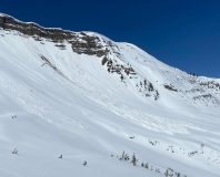
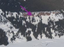
Avalanches: Not sure when these ran or if they’ve already been documented. North end of Schuylkill ridge, probably ENE facing? And Purple Ridge near Poverty Gultch, SW facing. See photos.

Weather: Windy AF up high, in and out of clouds, cool air temps

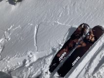
Snowpack: Skiing just before noon, South facing at 12,500 showed minimal signs of softening. By 12,000 the top inch was soft. By 11,500 and SE exposure we got into full corn, 2-3 inches of soft snow. Mushy but still supportive by 10,500 at 12:15.

Photos:

Read Full Observation
The blog.