March 16 – 31st: High Pressure and Wet Avalanches Followed by Minor Disturbances and Small Winds Slabs

CBAC2016 - 17 Weekly Snowpack Summaries, Weekly Snowpack Summaries

By Arden Feldman            CBAC Intern

The major dome of high pressure over the western US continued to bring calm, sunny weather and record high temperatures to the Crested Butte area for another week. The Elkton weather station at 11,000 ft recorded daytime highs in the mid to upper 40s from March 15th through the 21st, and nighttime lows that did not drop below freezing from the 14th through the 20th. It was full blown “beach weather” for Crested Butte’s spring break. On the 21st a moisture-laden Pacific trough began digging towards the California/Baja coast. This initially brought a warm, moist southwest flow with a mix of sun and clouds through the 22nd. On the 23rd, the high pressure and above average temperatures were finally pushed out by the trough and a closed low pressure system began impacting Colorado with a cold front. The storm hammered the San Juan Mountains but came in relatively light for our area with Irwin and CBMR reporting 2-4 inches on the 24th, Schofield Pass recording 9 inches, and unusually tame NW winds gusting into the 40s. Skies cleared by the morning of the 25th allowing for fantastic weather for the Grand Traverse. A weak, fast moving trough brought light snow showers to the area that night. The storm quickly moved past and skies cleared again, with generally cooler temperatures on the 26th and 27th. Overnight lows were back down to the low 20s. Spring squalls due to a closed low moving overhead brought 3-4 inches of snow on the night of the 27th into the morning of the 28th. The 29th and 30th were another set of warm and calm days before a final closed low pressure system on the 31st. This storm came in light and warm with general accumulations of 1-2 inches and 6 inches at Schofield Pass.

3/20/17 – Satellite image showing the moist Pacific trough beginning to impact the west coast.


On March 16th the persistent slab problem was finally removed from the list. The last human triggered persistent slab avalanche on the buried near surface facets occurred on March 4th, suggesting the layer had become dormant or unreactive in its dry snow state. However, the string of increasingly warm days without solid overnight freezes introduced more and more free water into the snowpack, especially on east, south, and west aspects, and persistent slab concerns were replaced with wet slab concerns. This free water was getting deep enough in the snowpack to pool up on these buried crusts and weak layers, potentially destabilizing them and threatening to release wet slab avalanches. Wet slab avalanches remained on the problem list until the 23rd when colder temperatures aided in refreezing the snowpack.

3/18/17 – Natural wet slab/glide crack avalanche on an east aspect at 10,500ft.


The continued warm weather with poor refreezes was also causing an increase in frequency and potential size of wet loose avalanches. The large amount of free water in the snowpack was creating the potential for small point releases to gouge down and become bigger and far more consequential. On the 22nd, this threat, along with wet slab concerns, raised the avalanche danger to Considerable below tree line. Large wet loose avalanches posed a threat until the 24th when new snow and a solid freeze limited the wet loose avalanche concerns to small surface instabilities through the 25th. Loose wet avalanches then stayed off the problem list until the 29th and 30th, when warmer temperatures and some new snow brought back the potential for small wet loose avalanches involving the fresh snow.

3/16/17 – Large natural wet loose avalanche on Gibson Ridge.


3/19/17 – Large natural wet avalanche below Gothic Peak that gouged down and triggered wet slab avalanches on its flanks.


The 2-9 inches of new snow combined with moderate NW winds on the 23rd, added small wind slabs to the problem list until the 25th. The spring snow squalls on the night of the 27th again added small wind slabs to the problem list on the 28th. In both cases the wind slabs were confined to loaded, above tree line slopes. On the 26th, 27th, and 31st, solid overnight freezes and little to no fresh snow resulted in no avalanche problems and the avalanche danger being rated at Low at all elevations.

March 3rd – 15th: A Windy Storm leads into High Pressure and a Stabilizing Snowpack

CBAC2016 - 17 Weekly Snowpack Summaries, Weekly Snowpack Summaries

By Arden Feldman            CBAC Intern

With a broad ridge of high pressure shifting east over the continental US, March 3rd and 4th were quite pleasant with sunny skies, light winds, and daytime high temperatures just above freezing. The next Pacific trough of low pressure began coming ashore on the 5th, briefly bringing back stormy weather. An associated cold front on the morning of the 6th brought 4 to 7 inches of new snow and cold temperatures, but the big story was the extreme westerly winds mixing down to all elevations caused by a relatively low elevation jet and a strong pressure gradient. On the morning of the 6th, winds were blowing at 60 mph and gusting to 100 mph on Scarp Ridge. On the 7th the storm track shifted northward as a high pressure began to build over the West. The high pressure lasted through the rest of the work week and brought a warming trend, calm winds and sunny skies. On the 10th, Elkton reached a high temperature of 43 degrees Fahrenheit. A pair of fast moving disturbances brought back unsettled weather on the 11th and 12th. These shortwave troughs resulted in some snow further north, but only brought increased clouds and gusty winds around the Crested Butte Area. High pressure took hold over the West again on the 13th allowing for calm and dry weather and temperatures approaching near record highs through the 15th.

3/9/17 – Satellite image showing the first disturbance heading for Colorado.


3/13/17 – Satellite image showing the second disturbance fleeing to the east.


Persistent slabs 1 to 3 feet thick over facets and facet crust combos buried mid February remained an avalanche problem through the first half of March on north through southeast aspects. These slabs remained sensitive to triggers through the first week of March. The problem slowly stabilized, and the danger dropped from Considerable on March 3rd to Moderate on the 4th and 5th. The extreme wind event on the 6th added weight to the slabs and raised the danger back to Considerable for the day. Eventually, after more time to stabilize and a lull in avalanche activity, the danger dropped down to Low at all elevation bands on the 13th.

3/2/17 – Skier triggered persistent slab avalanche on a NE aspect NTL on a very thin, faceted crust.


3/2/17 – Persistent slab avalanches in Evan’s Basin.


3/2/17 – Natural D2 slab avalanche on an ENE aspect ATL.


March 3rd and 4th brought the first above freezing temperatures since the new snow on February 28th, adding loose wet avalanches to the problem list. These avalanches were small but concerning due to the potential for them to subsequently trigger larger persistent slab avalanches. Loose wet avalanches came back to the problem list on the 14th and 15th due to the near record high temperatures. They remained relatively small, but still potentially consequential.

3/14/17 – Wet slab/mud slide near Kebler Pass Road.


The extreme westerly wind event on the 6th added wind slabs to the problem list through the 8th. The wind event seemed to do more wind scouring than loading, but some spots still harbored small but dense wind slabs that would make for unpleasant surprises, especially in consequential terrain.

February 24th – March 2nd: Powerful Storm Causes Widespread Natural Slab Avalanche Cycle

CBAC2016 - 17 Weekly Snowpack Summaries, Weekly Snowpack Summaries

By Arden Feldman            CBAC Intern

After the cold front on February 23rd, the Crested Butte area was stuck in cold, northwest flow until the 26th. Embedded disturbances within the flow kept clouds and convective snow showers overhead during this period but did not result in significant accumulations. Temperatures were cold with a high at Elkton of 6 degrees Fahrenheit on the 24th, reminding ourselves how soft we’ve gotten during this unusually warm winter. Ahead of an incoming storm, southwesterly flow increased on the 26th resulting in gusty winds. The combination of a cold front, the jet stream bringing in subtropical moisture, and an upper level low pressure trough further adding instability, resulted in a powerful winter storm on the 27th and 28th. By the evening of the 28th, 8 to 25 inches of snow fell across the forecast area. Schofield Pass picked up 25” of snow (2.4” SWE) while Kebler Pass received 18” of snow (1.5” SWE). For the rest of the week, the Crested Butte area remained in dry, cold, northwest flow allowing for light winds, sunny skies, and cold temperatures.

2/27/17 – Satellite image showing the major storm system impacting Colorado.


Wind slabs from strong winds the week prior and continued winds this week remained the primary avalanche problem through the first half of the week. On February 25th, the persistent slab problem from the surface hoar layer buried January 19th was finally put to rest and taken off the problem list. This was after over two weeks without a persistent slab avalanche being reported in our forecast area, and 11 days since one was reported in the Aspen Zone. We were allowed two days without a persistent slab problem until a new persistent weak layer became active during the powerful storm on the 27th. A layer of near surface facets that formed during the previous dry weather was now being put to the test. On the 28th the avalanche danger was raised to Considerable at all elevations and we were dealing with a significant natural slab avalanche cycle. These slabs were primarily failing on fragile facet and crust-facet layers 1-3 feet deep, most commonly on easterly facing wind-loaded aspects above treeline. The storm also brought about wind and storm slabs that were quick to heal and off the problem list by March 2nd.


3/1/17 – Large persistent slab avalanche on a SE aspect ATL.


3/1/17 – Multiple slab avalanches on E aspects ATL.


3/1/17 – Natural D2 slab avalanche on a NE aspect.


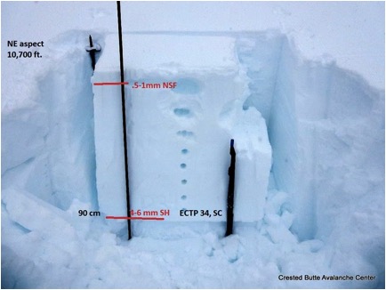
2/26/17 – Snow pit showing an example of the concerning crust facet sandwich in our snowpack.


2/23/17 – Small wind slab on a SE aspect NTL.

February 17th – 23rd: Unsettled Weather and Wind Slabs

CBAC2016 - 17 Weekly Snowpack Summaries, Weekly Snowpack Summaries

By Arden Feldman CBAC Intern

The week began clear and warm on February 17th but high clouds began to build on the 18th from a deep Pacific trough making landfall on the California coast. Moisture associated with the trough began streaming in from the southwest on the 18th but unfortunately the bulk of the energy and precipitation remained out near the west coast. Accumulations were only marginal with occasional light snow showers into the 19th. On the afternoon of the 19th a low pressure trough moved over Colorado, bringing with it a warm, moist air mass with southerly flow. This system brought snowfall through the night and resulted in 2 to 8 inches of snow across our area by the morning of the 20th, favoring the Kebler Pass and Paradise Divide zones. Strong westerly winds accompanied the new snow.

A temporary ridge built overhead on the 20th allowing for scattered skies and warm temperatures. Another Pacific trough began to move onshore on the 21st, quickly breaking down the ridge. Associated moist southwest flow stayed to our north and west in Wyoming and Utah. Being on the edge of this flow we saw increasing clouds and strong winds on the 21st and 22nd. The Elkton weather station recorded a 102 mph gust on the 21st. Finally on the morning of the 23rd a cold front drifted south over the Elk Mountains and brought steady snowfall with it. 8 to 10 inches of snow, driven by strong west to northwest winds, accumulated on the 23rd. The Schofield Pass Snotel Site recorded .5” of SWE and 10” of snow.

2/20/17 – Satellite image showing the break between storms on February 20th and the approaching system that would bring 100+ mph wind gusts and a quick blast of snow.


Persistent slabs on buried surface hoar 1 to 3 feet deep were the avalanche problem in the beginning of the week. The slabs were becoming increasingly unreactive but were still possible to trigger on near tree line northerly slopes. By the end of the week they had become unlikely to trigger. No new persistent slabs were observed this week and the last reported persistent slab occurred on February 14th in the Aspen Zone.

2/20/17 – Snow pit showing a 3 foot slab over propagating surface hoar on a NE aspect near tree line.


The new snow and strong westerly winds on the afternoon of the 19th built wind slabs on leeward aspects near and above tree line, and wind slabs were added to the problem list on the 20th. With continued strong winds and more snow on the 23rd, the wind slabs stuck around through the end of the week and kept the avalanche danger rating at moderate near and above tree line. They remained possible to trigger and small to large in size. During the second half of the week, several wind slabs were skier triggered and were responsible for a couple of close calls (Coon Basin, Purple Peak). ­­

2/20/17 – Remotely triggered wind slab that ran 1,500 feet.


2/21/17 – Crown of a large wind slab avalanche that caught, partially buried, and injured a skier.


2/20/17 – Skier triggered wind slab on an east aspect at Irwin.

February 10th – 16th: Warm Temperatures with Snow and Low Elevation Rain

CBAC2016 - 17 Weekly Snowpack Summaries, Weekly Snowpack Summaries

By Arden Feldman            CBAC Intern

The week started off balmy on February 10th with warm, moist southwest flow issuing in record high temperatures for the second day in a row. billy barr’s Gothic weather station recorded a record high of 48 degrees. A closed low off of the California coast began streaming unusually warm Pacific moisture into Colorado during the evening of the 10th. This caused increasing clouds and precipitation to filter into the region with strong winds. The freezing level was around 10,000 feet, so downtown Crested Butte and many below tree line slopes received rain, while higher elevations received dense snow. Winds on the 10th averaged 24 mph and gusted up to 89 mph at 11,000 ft. On the evening of the 11th, a cold front passed overhead sparking heavy snowfall and allowing temperatures to finally drop below freezing throughout the forecast area. By the morning of the 12th, 3” of SWE and 19” of snow had accumulated at Schofield Pass, and 14” of snow was reported at CBMR.

2/11/17 – Satellite image showing the Pacific moisture flowing into Colorado.


On the 12th, the atmospheric flow split around Colorado with the main flow to our north and the cut off low to our south. The low was still sending some leftover moisture into our area with a southerly flow, causing light snow showers.. The flow then began to dry out, beginning a clearing and warming trend through the rest of the week. On the 14th there was a high of 22F at 11,000 ft but by the 16th, there was a high of 44F with beautiful clear skies.

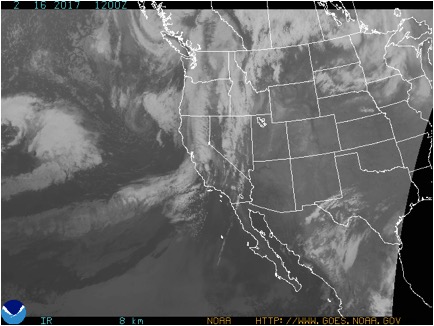
2/16/17 – Satellite image showing clear skies over Colorado.


Persistent slabs on buried surface hoar layers on northerly and easterly aspects remained a problem this week. This week’s storm added a significant new load to the snowpack and tested the persistent weak layers, and we observed a handful of natural avalanches failing on buried surface hoar or facets again. The instabilities became increasingly isolated and stubborn through the week, but they were still present and sadly consequential, resulting in Colorado’s first fatality of the season in the Flat Tops. The storm also resulted in storm slab concerns, but few were reported likely due to the limited visibility during the storm.

2/14/17 – Natural D2 slab avalanche on a northeast aspect of Mt. Axtell.


2/14/17 – Persistent slab avalanche in the Flat Tops zone that resulted in the first avalanche fatality of the season in Colorado.


2/14/16 – Natural slab avalanche on a northeast aspect that appeared to fail on surface hoar.


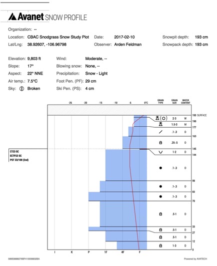
2/10/17 – CBAC Snodgrass Snow Study Plot profile showing the problematic surface hoar layer.


The warm temperatures and low elevation rain during the week resulted in wet avalanche problems. Relatively small but potentially consequential natural (here, here, here) and skier triggered wet loose avalanches were observed throughout the week, and with the rain below tree line, and several wet slab avalanches were also observed.

2/17/17 – Wet loose avalanche cycle on east, south and west aspects.


2/19/17 – D2 wet slab avalanche on a south aspect ATL.

February 3rd – 9th: Two Windy Storms and Record Warmth

CBAC2016 - 17 Weekly Snowpack Summaries, Weekly Snowpack Summaries

By Arden Feldman            CBAC Intern

The week started off dry and warm early on the 3rd, but a weak storm impacted the area overnight into the 4th. It brought 4-5 inches of snow (.6” of SWE at Schofield Pass). Southwest winds were blowing strong during the storm with gusts up to 64 mph on the 3rd at 11,000 ft. February 5th offered a brief pause in the storminess with few clouds in the sky and temps rising to 34F at 11,000 ft.

2/3/17 – Satellite image showing the weak first storm of the week affecting Colorado.


A stronger, warm and wet winter storm began to affect our area on February 6th and lasted into the 8th. Over the course of the storm, Schofield pass picked up 1.7” of SWE and 11” of snow, Mount Crested Butte recorded 1.9” of SWE and 11” of snow, and Irwin received 20” of snow. Much of the snow consisted of graupel at lower elevations. The storm brought with it strong winds out of the west, averaging 23 mph and gusting up to 89 mph on the 7th at 11,000 ft. The storm slowly subsided during the day on the 8th and by the 9th skies were scattered and temperatures were skyrocketing. Billy Barr’s weather station in Gothic recorded a record high for the day of 47F.

2/7/17 – Satellite image showing the stronger second storm of the week impacting Colorado.


The beginning of the week continued the trend of slowly stabilizing persistent slabs on the 1/19 surface hoar layer. Persistent slab instabilities were becoming increasingly isolated and stubborn, but also consequentially dense and 1-3 feet thick. On the 4th, a persistent slab on the 1/19 surface hoar layer was skier triggered in the neighboring Aspen zone.

2/4/17 – Skier triggered persistent slab avalanche running on the 1/19 surface hoar layer in the neighboring Aspen Zone.


2/5/17- Pit results showing the spatial variability of the buried surface hoar problem.


Wind slabs on leeward aspects above tree line were added to the problem list on the 4th due to the strong winds of the first storm of the week. But with only meager storm totals during that first storm, the wind slabs remained small until the second storm of the week. These wind slabs became larger and more widespread with the second storm. Numerous natural and skier triggered (here, here, here, and here) wind slab avalanches were observed. The second concern with this loading event was increasing sensitivity of the buried surface hoar layer resulting in large persistent slab avalanches. Northerly and easterly aspects near and below tree line remained the most suspect slopes for the dangerous surface hoar layer. A few skier triggered persistent slabs on surface hoar were observed after the second storm. With the record warmth on the 9th, wet loose avalanches were added to the problem list and were observed on steep slopes around the compass, especially below tree line. A very large avalanche also ran naturally off of Gothic Mountain on the 9th.

2/7/17 – Skier triggered wind slab on a SE aspect near tree line.


2/7/17 – Skier triggered wind slab.


2/8/17 – Natural D2 wind slab on a SE aspect of White Mountain.


2/9/17 – Natural wet loose avalanches on a south aspect of Gothic Mountain.

January 27th – February 2nd: High pressure and lurking instabilities

CBAC2016 - 17 Weekly Snowpack Summaries, Weekly Snowpack Summaries

By Arden Feldman            CBAC Intern

The Elk Mountains remained under a high pressure ridge with dry, mostly clear skies and warming temperatures for the duration of the week. Cool northwesterly flow started the week off cold with strong valley inversions and clear skies. On the morning of January 27th, the temperature was down to -32F in town and -10F up at the Elkton weather station at 11,000 ft. On the 27th, winds at Elkton averaged 12 mph and gusted to 32 mph out of the northwest, transporting last week’s snow into wind slabs on leeward aspects above tree line. Similar winds continued out of the northwest until January 31st, but temperatures increased over that time. On the 31st, Elkton recorded a high of 33F and a low of 23F, while down in town there was a high of 40F and a low of -8F. These warm temperatures formed stout melt-freeze crusts on southerly aspects over the week. Flow changed to the southwest later in the week, and winds continued but were running low on snow available for transport.

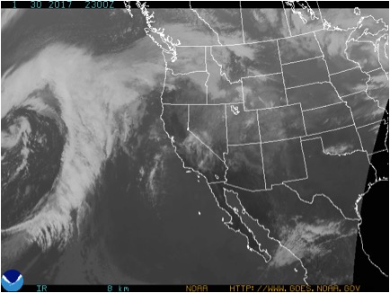
1/30/17 – Satellite image showing relatively clear skies over Colorado.


Avalanche instabilities slowly stabilized over the week. Wind slabs and persistent slabs were the primary concerns. Wind slabs formed on leeward aspects during the northwest winds in the beginning of the week. Observers reported a handful of natural wind slabs running on steep, windloaded terrain at higher elevations. On the 1st, an experienced backcountry skier was caught, carried, and sustained multiple injuries after being washed over several cliffs and trees by a relatively small wind slab in consequential, westerly facing terrain above Copper Creek near Gothic

1/27/17 – Natural D1 wind slab that was possibly cornice triggered.


1/31/17 – Natural D1 wind slab.


1/30/17 – Remotely triggered D1 wind slab.


The 1/19 surface hoar continued to plague our area, with reactive persistent slabs up to several feet thick. They became harder to trigger as the week progressed, but they still lurked and avalanches on this layer were triggered almost every day of the week in either our zone or the neighboring Aspen zone. Northerly and easterly aspects near and below tree line were the most suspect slopes to contain the dangerous surface hoar layer.

1/27/17 – Explosive triggered D2 persistent slab.


1/28/17 – Snowmobile triggered D1 avalanche that ran across Kebler Pass Road.


1/31/17 – Natural D2 persistent slab avalanche that likely ran at the end of the last storm cycle.


1/30/17 – Avalanche rose showing persistent slab avalanche activity since January 19th.


1/28/17 – CBAC Snodgrass Snow Study Plot profile showing the problematic surface hoar layer.

January 20th – 27th: Three Storms Bury a Widespread Surface Hoar Layer

CBAC2016 - 17 Weekly Snowpack Summaries, Weekly Snowpack Summaries

By Arden Feldman            CBAC Intern

The week consisted of three separate storms that kept clouds and snow in the air for most of the week. The first storm began on the night of the 19th and continued through the afternoon of the 20th. It brought with it low-density snow and very little wind, preserving and burying the surface hoar that had grown and had been observed on all aspects up to at least 12,000 feet in elevation. The western part of the zone received significantly higher snow totals with 24” of new snow reported in the paradise divide zone on the 20th. Schofield received .7” of SWE and Mt. Crested Butte received .4” of SWE.


1/20/17 – Satellite image showing the first storm of the week impacting Colorado.


On the 21st, the second storm came in lighter than forecasted and resulted in mostly light snow showers across the zone. Schofield received .3” of SWE. A small ridge then formed over the western US on the 22nd allowing for a short break in the storm pattern. The third storm combined Pacific moisture and a strong upper level jet to hit our area ferociously on the 23rd. We experienced extreme southwest winds and intense snow transport, even in town. During the day on the 23rd, Scarp Ridge recorded consistent 60 mph winds and a maximum gust of 111 mph. Schofield received 2” of SWE and Mt. Crested Butte received 1” of SWE.

1/23/17 – Satellite image showing the windy third storm impacting Colorado.


From the 24th through the end of the week on the 26th, the third storm exiting to our east brought a northwest flow over our area causing light snow, generally broken skies, and cold temperatures.

This week’s snow buried a widespread surface hoar layer on all aspects along with a reactive faceted crust on southerly tilts. In the beginning of the week, the slab above it was too soft and thin for failures to propagate, but as the snow accumulated over the week, the slab grew and the surface hoar layer became very reactive. Numerous natural and skier triggered avalanches were observed failing on the surface hoar, even on low angle slopes, in relatively dense aspen groves, and as remote triggers. The avalanche danger was rated at considerable or high every day of the week other than the first day of the storm, Jan 20th. In places, the surface hoar layer was deceptively touchy: we had several field days where it didn’t produce propagating results in ECTs but was easily triggered on steep terrain. The extreme southwest winds with intense snow transport likely created wind slabs in the alpine, but with continued snow transport and limited alpine views, evidence of them was likely quickly covered up. Over the course of the week, 39 natural and 37 human triggered avalanches were observed, and we had limited views of alpine terrain.

1/26/16 – Skier triggered avalanche on the surface hoar layer in an aspen grove.


1/26/17 – Skier triggered avalanche on the surface hoar layer that pulled out to a 31 degree ridge.


1/24/17 – Remotely triggered avalanches on the surface hoar layer with wide propagation.


1/24/17 – Natural avalanche on the surface hoar layer on a northeast aspect below tree line.


1/26/17 – Natural avalanche on a southeast aspect near tree line.


1/26/17 – Skier triggered avalanche on the surface hoar layer on a north aspect below tree line.

January 13th – 19th: Cut Off Low and Surface Hoar Formation under Brief High Pressure

CBAC2016 - 17 Weekly Snowpack Summaries, Weekly Snowpack Summaries

By Arden Feldman            CBAC Intern

The same cut off low from January 12th continued to impact Colorado until the 16th. It slowly meandered from Baja to the Arizona/Mexico Border and finally on to Texas while spinning multiple ripples of moisture into our area with increasingly less favorable atmospheric flow directions. This kept light snow showers and cloud cover over Crested Butte until the 16th. Schofield received .5” of SWE on the 13th and .4” of SWE on the 14th. CBMR reported 3” of new snow on the morning of the 14th, another 3” on the 15th, and 1” on the 16th.


1/13/17 – Satellite image showing the cut off low near Baja sending moisture into Colorado.


The weak trough slowly slid its way far enough east to allow for high pressure to build over Colorado on the 16th. The high pressure lasted through the end of the week, allowing for the first major break in storminess in over two weeks. A pleasant reminder that the sun does in fact still exist! Although the sun was out at high elevations, impressive inversions created spectacular valley fog unusual for our area. Clear, calm nights allowed for widespread surface hoar growth. At the end of the week, on the evening of the 19th, snow began to fall again, burying the surface hoar and making it our next problematic persistent weak layer.

1/16/17 – Unusual valley fog below Mount Crested Butte.


1/19/17 – Surface hoar sitting on top of a soft crust on a southwest aspect.


Last week’s historic storm left us with dense slabs, generally 3-5 feet thick, plastered across all aspects. These slabs are sitting on persistent weak layers at the storm interface and down near the ground. Clearing skies over the week finally gave views of avalanches that occurred during the storm cycle. Several large, natural deep slab avalanches, up to size D4, were observed. With the calm weather, avalanche instabilities slowly stabilized over the week. The deep persistent slab problem lurking in our snowpack was the main avalanche concern with storm slabs coming off the problem list by the 15th. The deep slab problem was slowly healing and represented a low likelihood but very high consequence event. No deep slab avalanches were reported occurring in our zone over the week but one deep slab did run naturally in the neighboring Aspen zone on the 17th.

1/13/17 – CBAC Snodgrass Snow Study Plot profile showing the thick slab formed during the historic storm that is sitting upon healing weak layers.


1/16/17 – Extent of debris pile of D4 avalanche on northwest aspect of Scarp Ridge that destroyed mature timber.


1/16/17 – Partially filled in crown of D2.5 avalanche on an east aspect of Mt. Emmons.


1/17/17 – Crown of deep slab avalanche on northeast aspect of Cascade Peak.


1/17/17 – D3 deep slab avalanche that ran naturally on the 17th in the neighboring Aspen zone.

January 7th-12th: A Storm for the History Books

CBAC2016 - 17 Weekly Snowpack Summaries, Weekly Snowpack Summaries

By Arden Feldman            CBAC Intern

The week started off dry and extremely cold with valley temperatures on the morning of January 7th ranging from -25 to -35 F and mountain temperatures hovering just above zero. That weather did not last long as a very moist and warm air mass started infiltrating the area on the 8th from the west-southwest causing snow showers to ramp up again after last week’s snow. This air mass continued flowing into the area from the Pacific through the 9th bringing with it impressive amounts of precipitation and strong winds. With temperatures hovering right around the freezing mark, the precipitation fell as very wet snow. On the night of the 9th a cold front passed over initially causing heavy snowfall and strong winds, but eventually allowing for a lull in the storm on the 10th. From the 8th through the 9th Schofield picked up 5” of SWE and 26” of snow with 3” of SWE falling in a mere 16 hours on the 9th. CBMR received 2.5” of SWE and 30” of snow. On the 9th, the Crested Butte Community School closed for the first time since 1970 and CBMR closed early due to safety concerns. People were calling it the snowpocalypse.

1/9/17 – Satellite image from the National Weather Service showing the abundant moisture beginning to hit Colorado from the Pacific.


Staying true to its character, during the “lull” on the 10th, the storm still brought in 6-8” of new snow and strong winds. Elkton had sustained winds of 16 mph and gusts up to 94 mph. On the 11th we saw pacific moisture flowing into the area from the west-southwest yet again and another cold front passing over that night. This resulted in yet another pulse of heavy snow and strong winds. During this pulse, Schofield picked up 1.6” of SWE and 9” of snow and CBMR received 10” of snow. Elkton recorded sustained winds of 18 mph and gusts up to 76 mph.

On January 12th a low pressure system off the coast of California began to sag towards Baja and cut off from the main atmospheric flow. The southerly flow of this cut off storm sent warm temperatures and one more significant plume of moisture into our area resulting in another 1.4” of SWE falling at Schofield.

1/12/17 – Satellite image from the National Weather Service showing moisture from the cut off low impacting Colorado.


Since January 1st, the Gunnison Valley has been in the bull’s-eye for moisture from the Pacific. After that last plume of moisture on the 12th, Schofield pass now stands at 14” of SWE since the storm cycle began on January 1st. That makes this storm the largest in history since the Schofield Snotel was established in 1985! As of January 12th, the Gunnison River Basin snowpack is at 166% of normal for this time of year. That means the snowpack is already deeper than it ever got during the 14/15 season, and it’s only early January!

1/12/17 – Gunnison River Basin snowpack summary showing our deep snowpack.


The week began with avalanche conditions beginning to stabilize after the previous week’s snow with considerable danger on the 7th dropping to moderate on the 8th. The impressive snow amounts that fell on the 8th and 9th added a large load to the snowpack, causing the avalanche danger to rise to high with an avalanche warning on the 9th. With heavy snow and strong winds continuing through the week, the avalanche danger never fell below high. On the 11th, an extreme (L5) avalanche danger was issued, a rare occurrence. Since 1985 we have only seen 4 or 5 events that met that criteria. In this case, the historic amount of snow that fell since January 1st created a massive slab that was sitting on a number of persistent weak layers that were detailed in last week’s summary, including crusts, facets, surface hoar, and depth hoar. Very large storm slabs were also running. Both of these problems were forecasted to be widespread and large enough to run into valley bottoms and reach historic lengths.

With snow continuing to fall through the end of the week, we haven’t gotten good enough visibility to observe this storm’s avalanches out in the mountains. Still, we have had reports from across the state that indicate the historic nature of this storm with avalanches running across Taylor Canyon, I-70, and Red Mountain Pass, local roofs collapsing and historic mine structures demolished by avalanches. Locally, two avalanches ran across Kebler Pass road (first, second), a patroller was caught in a slide at CBMR, and many avalanches up to size D2.5 were reported even with our limited visibility. Large roof avalanches were also common in town.

1/9/17 – Natural D2.5 persistent slab avalanche on Red Ridge that ran to the ground in places.


1/9/17 – Crown of natural D2.5 persistent slab avalanche that ran across Kebler Pass Road.


1/12/17 – Debris of an avalanche that crossed Taylor canyon into a popular fishing hole. Definitely large enough to kill a fish!