Southerly avalanches

CB Avalanche Center2020-21 Observations

Date of Observation: 01/06/2021
Name: Ben Pritchett

Zone: Northwest Mountains
Location: Mt. Baldy
Aspect: East, South East, South
Elevation: Above treeline

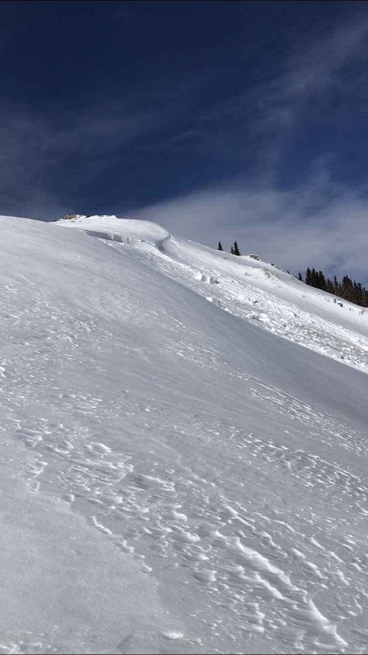
Avalanches: Observed 3 overnight natural avalanches on Mt. Baldy. One broke in Paradise Bolw on a west aspect, the other two broke on easterly-facing terarain. All three were continuing to load during the day and the crowns filled in during the day. We triggered two D2 avalanches in currently wind-loaded terrain. One triggered slide broke remotely on an alpine southeast-facing slope while we traversed a ridgeline above. It broke 1-2 feet deep, stepping into a layer of near surface facets below the recent interface. The other slide broke directly underfoot with some heavy stepping. We expected that we might remote trigger the slope that broke underfoot, but it didn’t go until we stepped on the edge of the slope. The actively loaded south-facing slope broke about 4-6″ deep under the front half of my skis. The slab broke about 100′ wide and pulled out a 3-4’fresh slab under a cornice. The slab ran around 300′ vertical depositing 2-5′ deep debris at the bottom of the slope.
2021/01/06 † Elkton 2 >TL E SS N R1 D2
2021/01/06 † Schofield Pass 1 >TL W SS N R1 D2
2021/01/06 † Elkton 1 >TL SE SS AS / r R1 D2
2021/01/06 † Elkton 1 >TL S SS AS / c R1 D2

Weather: Ridgeline Wind Speed: 20-30 mph
Ridgeline Wind Direction: NE
Wind Loading: Moderate
Temperature: 15 F
Sky Cover: Few
Depth of New Snow: 18 cm
Weather Description: Increasing northerly winds throughout the day with light to moderate drifting above treeline. High thin clouds moved in during the late afternoon.

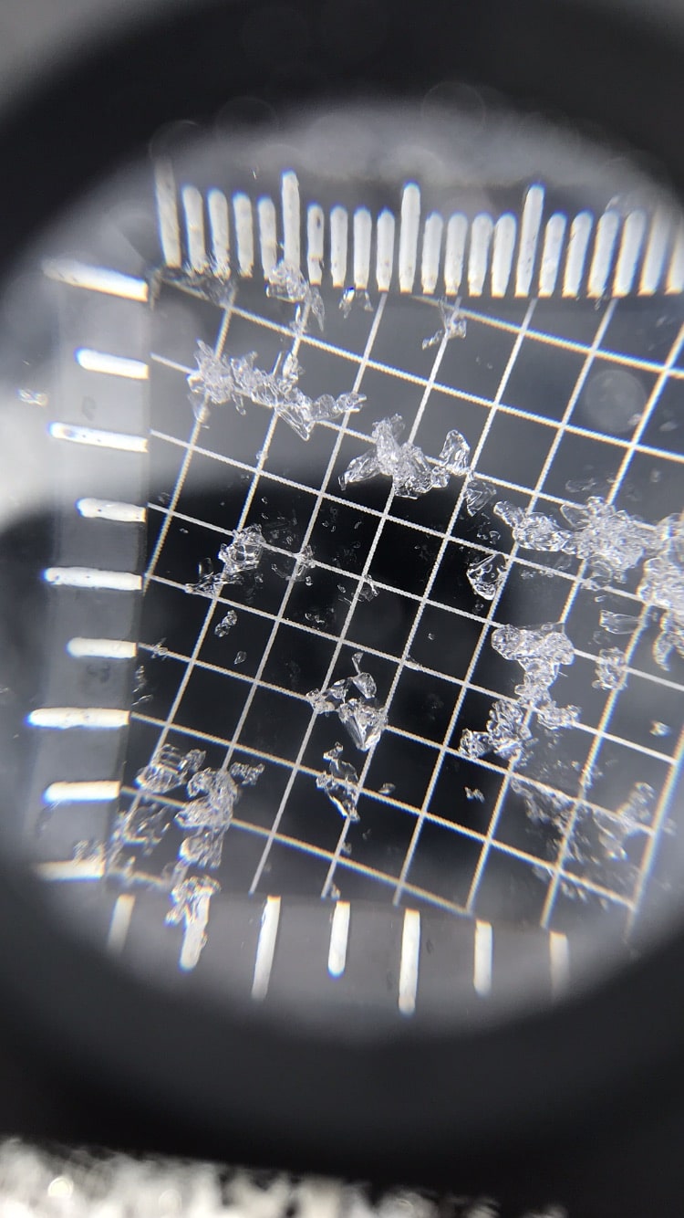
Snowpack: 6-8″ of new snow that was drifted on east through southeast to south-facing slopes near and above treeline. Slabby feeling snow with significant snow surface duning and ripples developed and changed through the day.


Photos:

Gothic South

CB Avalanche Center2020-21 Observations

Date of Observation: 01/06/2021
Name: Ian Havlick

Zone: Southeast Mountains
Location: Gothic Shoulder South
Aspect: South, South West, West
Elevation: 9,000-11,400

Avalanches: Only fresh avalanche observed was ~D1.5 on Baldy, off a windloaded southerly facing slope ATL. Likely will be reported by others closer to Baldy today.

Weather: Relatively cold morning, strong solar, moderate westerly winds ATL.

Snowpack: Several large collapses on flat terrain on Washington Gulch valley bottoms. More signs on instability on southerly, low angle terrain but NO signs of instability on southerly slopes with more slope angle. Travelled slopes up to 31º today. Steeper solar aspects were moist by 1300 and rollerballs and small wet loose out of warm, southerly facing terrain on Gothic. Dug one pit on low angle WNW facing slope BTL. Obvious weak layer but fairly faceted overlaying slab not producing propagation.. ECTX and CT30+1 SC.

Snodgrass study plot 1/4

CBAC2020-21 Observations

Date of Observation: 01/04/2021
Name: Jack Caprio
Zone: Southeast Mountains
Aspect: North East
Elevation: 10,000

Snowpack:

As of 1/4/21, the HS at the study plot (NE, 10,000) is 71 cm. 13 cm of F to 4F snow sits at the top of the snowpack. This layer represents the newer storm snow that fell over the past 10 days which buried the 12/26 interface @ 58 cm.

Below the 12/26 interface lies 10 more cm of 4F- snow leading to a buried NSF layer at 48 cm (12/22 interface). This interface initiated failure during an ECT test but did not propagate.

13 cm below the 12/22 interface is our old friend the 12/10 interface. This layer, which is 35 cm thick, has evolved into depth hoar near the ground. ECT tests resulted in propagating results (ECTP22 @ 12/10 interface). This same interface, when tested almost 2 weeks prior on 12/23/20 (snowpit attached in images), produced propagating results much more easily (ECTP7). According to the results over time, the 12/10 interface would appear to be becoming more stubborn. But with the 12/22, and 12/26 interfaces sitting above of the 12/10 interface, we are continuing to see plenty of avalanche activity on steep, sheltered NE facing terrain.


Snodgrass lap

CBAC2020-21 Observations

Date of Observation: 01/05/2021
Name: Eric Murrow Evan Ross

Zone: Southeast Mountains
Location: Snodgrass north side
Aspect: North, North East, East
Elevation: 9,400′ – 11,100′

Avalanches: Intentionally triggered a couple small loose avalanches on very steep features below ridgetop, just below 11,000′.

Weather: Mostly cloudy skies with snowfall rates between s-1 and s2. Several short periods of moderate snow. Accumulations as of 3pm around 4 inches.

Snowpack: Traveled above numerous northerly terrain features, many of which avalanched in December, without collapsing or signs of instability. Descended northerly slopes up to about 35 with no signs of instability. Traveled through some lower angled slopes that looked to have seen little traffic yet this winter without collapsing. One hasty pit showed a snowpack largely composed of fist hard snow around 90cm deep…just enough support for reasonable riding conditions. Other lower angled northerly features felt a bit stiffer while probing as compared to pit location. It is becoming hard to visually tell which slopes have avalanched in December and those that didn’t. We choose to avoid the steepest terrain and avoid features that had consequential runouts to hedge our bets.

No need for a shovel here, just wipe the snow away with your hand and make a wall. Simple snowpack structure. Soft faceting slab over weak facets. ENE Aspect, 10,600ft, HS ~90cm, Slope ~34

Purple Ridge

CB Avalanche Center2020-21 Observations

Date of Observation: 01/04/2021
Name: Alan Bernholtz


Zone: Northwest Mountains
Location: Purple ridge skin track
Aspect: East
Elevation: 10,500


Avalanches: None observed
Weather: Clear, cool, calm
Snowpack: The party of three discussed the days plan after all looking at the CBAC danger forecast. Purple Ridge. We knew there may be hazards in the snowpack and we decided to check it out. As we toured up the skin track, we heard several large collapses and observed cracking, The discussion was honest and open. We felt we could find a safe route up to the ridge and hoped the snowpack would become deeper and more stable the higher we went. Purple ridge had slid significantly during the last snow event. If we could get up high, it might be better. There were a lot of signs that the snowpack was not stable. Hollow, large facet layers on the ground, variable snowpack and unpredictability. A lot of times the third person would initiate the collapse. As we climbed, I felt uneasy with the terrain and the snowpack. Could we find a safe route up, yes. Was it worth the risk considering the terrain traps and snowpack signs of instability? I did not think so. The group was open and honest and realized there was different levels of risk acceptance. I had not been in the backcountry in several days. I could not justify the risk for the reward. 90% of the time it would have been fine but the 10% made me want to pull the plug on the tour. With the signs yelling at me from the snowpack and the terrain traps all around made me uncomfortable skiing that terrain. We are old friends, and it is hard to be the scardy cat but I was on this day. We turned around, skied conservatively back down to the snowmobiles and then went and skied a different aspect and angle allowing us to have a fun day skiing pow.
Morale of the story, talk, listen understand the risk and feel free to speak up and express your opinion. We will all ski together again.


Collapsing with diminishing propagation

CBAC2020-21 Observations

Date of Observation: 01/04/2021
Name: Zach Guy


Zone: Northwest Mountains
Location: East Beckwith
Aspect: North, North East
Elevation: 9,600 – 11,500′


Avalanches: Nothing fresh, some D2 slab activity from last cycle.
Weather: Few clouds, light winds.
Snowpack: Less than an inch of new snow overnight preserved large grained surface hoar on the near and below treeline slopes that we visited. There was enough wind in exposed locations to destroy it.
Still getting semi-frequent collapses below treeline and a few collapses near treeline. The latter triggered by second person on skin track or from hard stomps. The collapses didn’t produce much for shooting cracks, but judging off of how far away trees were shaking, it seems that most radiated less than 20 to 30 feet. This is a notable improvement from collapsing observed earlier in the week. We didn’t travel much near anything steep enough to avalanche; the few small test slopes below treeline that we stomped on didn’t produce any results. See attached photo for a profile at 10,600 feet, which produced moderate propagating results (ECTP14) 50 cm deep on 2 mm, fist hard facets.


Photos:

Valley bottom, Slate Rive Valley in the inversion zone

CBAC2020-21 Observations

Date of Observation: 01/04/2021
Name: Eric Murrow


Zone: Southeast Mountains
Location: Below Climax Chutes
Aspect: North, North East, East
Elevation: 8,900′ – 9,300′


Avalanches: Nothing new to report
Weather: Mostly clear skies, reasonable air temps, but guessing a fair bit cooler than areas above the inversion.
Snowpack: Very short tour walking about near valley bottom below Climax Chutes at the low end of Slate River Valley. Checked on snowpack where I would expect slabs to facet the quickest on shaded slopes. Ski pen was generally 6 to 8 inches with snowpack depth around 70cm (a bit more than 2 feet). Walked through areas with no previous traffic and only produced one notable collapse but stomped/jumped in many places looking for one. Many slopes in this area had previously cracked/collapsed this past week, likely during the loading event around the 28th or 29th. Slab is soft but still present even in the inversion zone, no propagating test results – see photo (profile location did not show evidence of the previous collapse but ya never know).

Photos:


Elkton

CB Avalanche Center2020-21 Observations

Date of Observation: 01/03/2021
Name: Ben Pritchett


Zone: Northwest Mountains
Location: Elkton area
Aspect: South East, South, South West, West
Elevation: Near and Above Treeline


Avalanches: One tiny fresh wind slab off the Treasury to Galena ridge.
Weather: Ridgeline Wind Speed: 10-20 mph
Ridgeline Wind Direction: NW
Wind Loading: Previous
Temperature: 15 F
Sky Cover: Few
Weather Description: Clouds increased late morning through the afternoon. Light to moderate northwest winds.
Snowpack: Travelled over alpine south and southeast-facing slopes. Near treeline we travelled on east through south to west. No cracking or collapsing observed. A week ago on a similar route in the same terrain collapsing was common near treeline, but not above. Overnight northwest winds transported snow only near alpine ridgelines. Drifts were soft and posed no threat.

Photo caption: Northwest winds scoured windward alpine ridges and built soft fresh drifts. January 3, 2021.


Photos:

Large Remote Trigger

CB Avalanche Center2020-21 Observations

Date of Observation: 01/03/2021
Name: Joey Carpenter


Zone: Southeast Mountains
Location: Ridge btwx West Brush Creek and Deer Creek trail
Aspect: East, South East, South
Elevation: 9.5k-11.1k


Avalanches: R2D2 unintentional remote trigger. About 150 feet away from low angle ridgeline. E aspect. 150 ft wide running 1200 vert. Avg crown 65cm with deepest portions reaching 95cms. Slope angle averaged 37 degrees but propagated onto angles as low as 34 in start zone. Shattering cracks on 31-32 degree slopes adjacent to slide path. Ran on 1-2mm facet capped crust. 1F hardness throughout majority of slab w/ 4f nearing the top from recent transport. This avalanche was small relative to the path but I am certain was unsurvivable. It ran through countless trees, rocks and other terrain traps. It snapped trees 3-4.5inches in diameter. The debris pile was 255cm deep at the bottom of the path and set up very firm. The unaffected snow adjacent to the debris pile was 70cm of fist hard facets to the ground which I’m certain the debris wiped out in the path, essentially making the debris pile over 8 feet deep.
Weather: Weather was sunny and warm around 10am at WBC/Deer creek junction with calm winds. Thin clouds filtered in from the southwest throughout the morning and by 1300 had made it 7/8 coverage with S towards gunnison still holding onto blue skies. Weather got progressively more unsettled making recording crown stats difficult due to snow, cold temps and 10-15mph ridge-top winds. S1- snowfall began around 2pm accompanied by continued 10-15mph sustained winds from the SW. A brief period of S2 came through but settled back out to S1-.
Snowpack: Spx on BTL S&SE tilting slopes was thin and weak. Below ~10.5k there was little slab structure if any. Collapses propagated short distances with minor cracking. As I gained elevation, cracking began to propagate further with more substantial cracking shooting ~70 feet and notable slab structure from pole probes. In attached photos of crown “profile” you can see the P- facet capped crust that acted as the bed surface. There was another P- crust below this with ~5cm of facets above and below. The spx from the 30cm to the ground started at 1f and slowly degraded to about F hard basal facets. The slab was 1F+ to 4f-, bottom up. The unpredictable nature of the avalanche problems this year are terrifying. Please be careful out there friends.


Photos:

Hunting a Dragon

CB Avalanche Center2020-21 Observations

Date of Observation: 01/03/2021
Name: Ben Ammon


Zone: Southeast Mountains
Location: Far Side Coney’s
Aspect: North, North East, East, South East, South, South West, West
Elevation: Up to 11,000′


Avalanches: No new ones observed.
Weather: Mod winds NW
Morning sun had warmed S and SE surfaces
Snow flurries through the afternoon, no accumulation noted
Snowpack: Several collapses on untracked W-facing slopes BTL, none observed on the untracked E and NE BTL slopes we traveled on.
NE aspect at 10,800′ had HS of 85cm, but much greater if you looked for wind-loaded pockets right below the ridgeline along Coney’s.
ECTN24 down 50cm on 12/10 interface
PST 45/100 END down 50cm on 12/10 interface