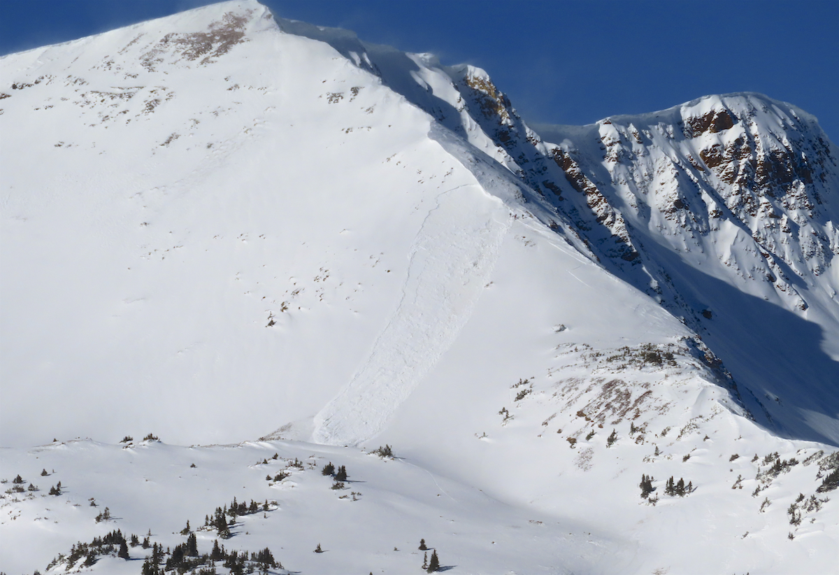
Few more shooting cracks in Washington Gulch

CBAC2020-21 Observations

Date of Observation: 01/06/2021
Name: Eric Murrow Evan Ross

Zone: Northwest Mountains
Location: Gothic Mountain
Aspect: West, North West
Elevation: 10,500ft to 11,200ft

Weather: Northwesterly winds moving snow at upper elevations, otherwise calm conditions where we traveled. Few clouds.

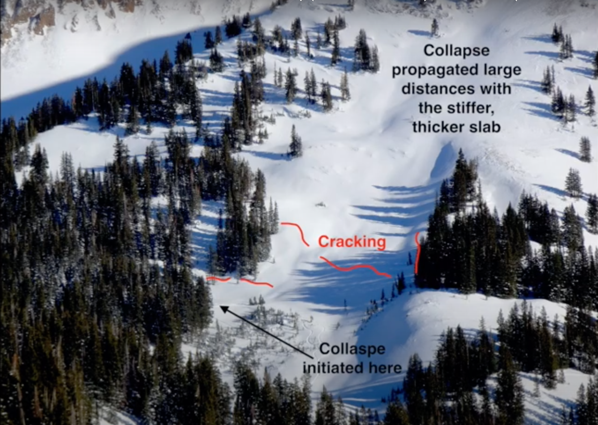
Snowpack: Traveled on west to northwest facing slopes below treeline. With some extra effort and a few heavy bounces, we were repeatably able to produce collapses and some long-running shooting cracks. These results were primarily failing on the early December facets. Those cracks ran into slope angels that reached up to about 35 degrees and sometimes displaced a couple of inches. A steeper or unsupported slope may have been necessary for an avalanche to release. We didn’t have the confidence to climb higher in the terrain since lower angle or low consequence route options were not closely available.

Looking at near treeline terrain. The avalanche problem appeared to be slightly more specific to the cross-loaded or gullied portions of the terrain. The same characteristics extended above treeline, but appeared even more isolated in the terrain due to more wind-scoured snow.

Snodgrass study plot 1/4

CBAC2020-21 Observations

Date of Observation: 01/04/2021
Name: Jack Caprio
Zone: Southeast Mountains
Aspect: North East
Elevation: 10,000

Snowpack:

As of 1/4/21, the HS at the study plot (NE, 10,000) is 71 cm. 13 cm of F to 4F snow sits at the top of the snowpack. This layer represents the newer storm snow that fell over the past 10 days which buried the 12/26 interface @ 58 cm.

Below the 12/26 interface lies 10 more cm of 4F- snow leading to a buried NSF layer at 48 cm (12/22 interface). This interface initiated failure during an ECT test but did not propagate.

13 cm below the 12/22 interface is our old friend the 12/10 interface. This layer, which is 35 cm thick, has evolved into depth hoar near the ground. ECT tests resulted in propagating results (ECTP22 @ 12/10 interface). This same interface, when tested almost 2 weeks prior on 12/23/20 (snowpit attached in images), produced propagating results much more easily (ECTP7). According to the results over time, the 12/10 interface would appear to be becoming more stubborn. But with the 12/22, and 12/26 interfaces sitting above of the 12/10 interface, we are continuing to see plenty of avalanche activity on steep, sheltered NE facing terrain.


Snodgrass lap

CBAC2020-21 Observations

Date of Observation: 01/05/2021
Name: Eric Murrow Evan Ross

Zone: Southeast Mountains
Location: Snodgrass north side
Aspect: North, North East, East
Elevation: 9,400′ – 11,100′

Avalanches: Intentionally triggered a couple small loose avalanches on very steep features below ridgetop, just below 11,000′.

Weather: Mostly cloudy skies with snowfall rates between s-1 and s2. Several short periods of moderate snow. Accumulations as of 3pm around 4 inches.

Snowpack: Traveled above numerous northerly terrain features, many of which avalanched in December, without collapsing or signs of instability. Descended northerly slopes up to about 35 with no signs of instability. Traveled through some lower angled slopes that looked to have seen little traffic yet this winter without collapsing. One hasty pit showed a snowpack largely composed of fist hard snow around 90cm deep…just enough support for reasonable riding conditions. Other lower angled northerly features felt a bit stiffer while probing as compared to pit location. It is becoming hard to visually tell which slopes have avalanched in December and those that didn’t. We choose to avoid the steepest terrain and avoid features that had consequential runouts to hedge our bets.

No need for a shovel here, just wipe the snow away with your hand and make a wall. Simple snowpack structure. Soft faceting slab over weak facets. ENE Aspect, 10,600ft, HS ~90cm, Slope ~34

Collapsing with diminishing propagation

CBAC2020-21 Observations

Date of Observation: 01/04/2021
Name: Zach Guy


Zone: Northwest Mountains
Location: East Beckwith
Aspect: North, North East
Elevation: 9,600 – 11,500′


Avalanches: Nothing fresh, some D2 slab activity from last cycle.
Weather: Few clouds, light winds.
Snowpack: Less than an inch of new snow overnight preserved large grained surface hoar on the near and below treeline slopes that we visited. There was enough wind in exposed locations to destroy it.
Still getting semi-frequent collapses below treeline and a few collapses near treeline. The latter triggered by second person on skin track or from hard stomps. The collapses didn’t produce much for shooting cracks, but judging off of how far away trees were shaking, it seems that most radiated less than 20 to 30 feet. This is a notable improvement from collapsing observed earlier in the week. We didn’t travel much near anything steep enough to avalanche; the few small test slopes below treeline that we stomped on didn’t produce any results. See attached photo for a profile at 10,600 feet, which produced moderate propagating results (ECTP14) 50 cm deep on 2 mm, fist hard facets.


Photos:

Valley bottom, Slate Rive Valley in the inversion zone

CBAC2020-21 Observations

Date of Observation: 01/04/2021
Name: Eric Murrow


Zone: Southeast Mountains
Location: Below Climax Chutes
Aspect: North, North East, East
Elevation: 8,900′ – 9,300′


Avalanches: Nothing new to report
Weather: Mostly clear skies, reasonable air temps, but guessing a fair bit cooler than areas above the inversion.
Snowpack: Very short tour walking about near valley bottom below Climax Chutes at the low end of Slate River Valley. Checked on snowpack where I would expect slabs to facet the quickest on shaded slopes. Ski pen was generally 6 to 8 inches with snowpack depth around 70cm (a bit more than 2 feet). Walked through areas with no previous traffic and only produced one notable collapse but stomped/jumped in many places looking for one. Many slopes in this area had previously cracked/collapsed this past week, likely during the loading event around the 28th or 29th. Slab is soft but still present even in the inversion zone, no propagating test results – see photo (profile location did not show evidence of the previous collapse but ya never know).

Photos:


Ruby Range

CBAC2020-21 Observations

Date of Observation: 01/02/2021
Name: Evan Ross

Zone: Northwest Mountains
Location: Ruby Range
Aspect: South East, South
Elevation: 10,700-12,600

Weather: Low clouds in the morning obscured the range, as those moved out a high cloud shield moved over for the mid day, with clearing in the afternoon. Increased winds were the main weather factor. Moderate speeds from the NW.

Snowpack: Snow surfaces that looked beautiful the last few days, had gotten affected by the recent increase in winds. In our case slopes that had the best SE to E tilt held soft snow surfaces, while some more southerly slopes had been blown back to old soft crusts or soft wind texture. Probably just due to the way the winds flowed through and around the terrain. In this area, there wasn’t much for new wind loading and the windward side of the terrain didn’t really have much snow for transport.

Several hand pits on S to SE facing slopes at upper elevations revealed no current avalanche problem. Never really found enough slab on the 12/10 curst to try and get a result. While skiing through areas that appeared to be more wind-loaded previously, also produced no results. Snowpack heights were measured were surprisingly shallow in the 40 to 60cm range on average. I wouldn’t have much trust in the snowpack structure observed during the next loading event. Those hand pits were on slope angles in the low 30-degree range. So the curst facet sandwich would be collapsible under new load with enough weight. Didn’t observe the thickness of those buried crusts on steeper slopes or the snowpack structure on the deeper looking sections of the slope.

Upper Cement

CBAC2020-21 Observations

Date of Observation: 01/01/2021
Name: Eric Murrow, Zach Kinler, Zach Guy


Zone: Southeast Mountains
Location: Upper Cement Creek
Aspect: North East, East, West
Elevation: Near and below treeline to 11,800′


Avalanches: This area got about 6″ of snow from Monday night’s storm and we saw limited evidence of natural activity from storm. A few D1 to 1.5s on easterly aspects. No avalanches triggered today.
Weather: Increasing clouds, a snowflake or two, light winds.
Snowpack: In Lower Cement, the persistent slab structure is poorly developed without enough snow to make a slab. As we gained elevation further up the basin (around 10,000′ near Block and Tackle trail), we started noticing shooting cracks and collapses. The slab is soft and a foot thick over fist hard depth hoar (3-4mm).  The snow surface and slab are faceting.  In less sheltered areas, there is a pencil hard wind crust near the 12/10 layer helping making for a drastic hardness change near the bottom of the slab. We experienced shooting cracks on both westerly and easterly aspects. In more wind affected areas, the collapses were localized to just drifted areas. We traveled adjacent to a few steep slopes and got them to collapse and crack remotely, but not avalanche.  We also got repeatable ECTPV results on the 12/10 layer in a pit on a NE aspect NTL.


Photos:

[/gravityforms]

Slate River

CBAC2020-21 Observations

Date of Observation: 01/01/2021
Name: Evan Ross

Zone: Northwest Mountains
Location: Slate River
Aspect: North East
Elevation: 9,000-11,400ft

Weather: The clouds came and then went again. Calm winds. Nothing notable.

Snowpack: The snowpack in this area is really variable given all the past avalanche activity it has seen throughout December. So it’s hard to make a call on the general stability. We traveled more aggressively on steep slopes where we had high confidence there wasn’t a current persistent slab avalanche problem due to past activity. We kept it real conservative where the conditions were unknown or undisturbed. The 12/10 interface remained the primary layer of concern. The more recent 12/22 layer of facets was observable, but we didn’t encounter any particular concerns there.

We didn’t get much for direct feedback, or obvious signs to instability. A few collapses and some shooting cracks all took some effort to produce. Confidence in the snowpack structure, where undisturbed, still remains low.

The upper 10 to 15cm’s of the snowpack is losing strength. SH was also widespread all the way to ridgeline. The slab had broken down the most at lower elevations below about 10,000ft.