Observations

01/10/21

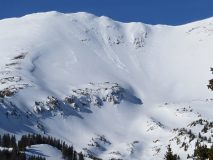
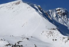
Large slide on Bellview

Date of Observation: 01/10/2021
Name: Zach Guy

Zone: Northwest Mountains
Location: Mt. Bellview
Aspect: South East
Elevation: ATL

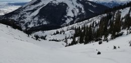
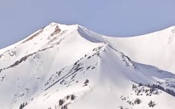
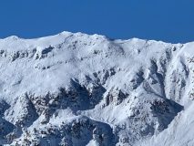
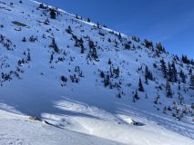
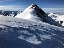
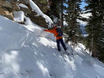
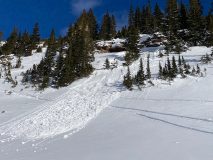
Avalanches: Large slab avalanche on the SE face of Bellview noted yesterday. We suspect this ran naturally during the windloading on 1/6.  Let us know if you have other information on the timing or trigger.

Photos:

Read Full Observation
01/09/21

Mt Axtell

Date of Observation: 01/09/2021
Name: Jared Berman & Jack Caprio

Zone: Northwest Mountains
Location: From Splains Gulch ascended the West face to the summit of Axtell. Skied South facing bowl before traveling back up S/SW ridge where we then skied the West face of Axtell back down to sleds
Aspect: North East, East, South-West, West
Elevation: 10,100ft – 12,500ft

Avalanches: None observed.

Weather: Broken clouds throughout the day and light winds from the NE. Several short periods of very light snowfall accumulating only trace amounts near and above treeline.

Snowpack:

The snowpack is still showing clear signs of instability on many aspects. However, collapsing and shooting cracks are only happening on specific terrain features and have started to become more stubborn.  Slabs are slowly faceting away but there are still many areas that hold a dangerous persistent slab structure.

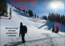
While ascending a westerly aspect below treeline, we felt periodic collapsing in open meadows where we found soft slabs resting on top of depth hoar (12/10 interface). These collapses were almost always initiated by the third skier. HS on west aspects is shallow near and below treeline averaging about 75cm.

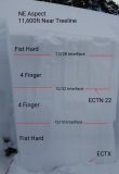
Near treeline on a SW aspect produced collapsing as well. One snowpit at this elevation/ aspect showed a 4F slab resting on top of Fist hard weak faceted snow. An Extended Column Test produced at ECTN21 at this location.

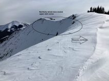
Moving around the compass to NE aspects we continued to experience several occasions of collapsing near and above treeline. Recent northerly winds did a number on start zones of the NE facing bowls of Axtell. These winds have created thin snow cover just below ridgetops that will surely weaken and become a problem at our next significant loading event.

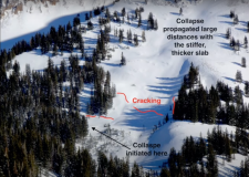
We spent little time on east aspects, but experienced the most exciting results in these areas. A large collapse was observed with shooting cracks that ran about 30ft on a small East facing convexity at 10,000′. A snowpit dug adjacent to the collapse yielded our only propagating results of the day (ECTP 14). These failures were initiated on a thin MF crust sitting on top of the depth hoar (12/10 interface).

Continuing to a Southerly aspect, the skiing was surprisingly great with the exception of areas with a stiff sun crust on steeper slopes. Lower angled sunny slopes continued to ski great.

Bottomline: Many suspect slopes are weakening as slabs are faceting out. Obvious signs of instability are becoming rarer although they are still present.  W-N-E facing slopes below treeline slopes continue to maintain a persistent slab structure, while East seems to be the most concerning.


Photos:

Read Full Observation
01/08/21

cold snow, some crust

Date of Observation: 01/08/2021

Zone: Northwest Mountains
Location: End of Washington Gulch
Aspect: South
Elevation: 10,000-12,000

Avalanches: Older natural on Baldy (previously reported)
Weather: sunny, low 20’s up high out of wind. Slight breeze on top. No snow transport.
Snowpack: Variety of depths as we skinned up maxing out at approx 120 cm on a below treeline south facing low angle slope. Small steeper and shallower S and SW pockets below treeline had a sun crust. Majority of the snow in protected areas was soft and awesome. Climbing the ridge between south and southeast bowls also varied in depth with new, wind loaded snow sitting on a slick and very firm surface in some spots. South facing bowl had a hint of a crust on steeper portion of descent (pole punched through the pack on one pole plant) that turned into cold pow once angle diminished. Partner found softer snow on eastern tilt of the south bowl. Ski pen 6 inches.


Read Full Observation
01/08/21

Weekly Snowpack/ Weather Summary Summary 1/8/21

Zone: Crested Butte Backcountry
Date: 01/08/2021
Name: Jack Caprio


This week’s action consisted of a quick storm along with a coinciding wind event on Tuesday (1/5/21). Here’s the weekly summary showcasing how this event impacted our snowpack.

Read Full Observation
01/07/21

Few more shooting cracks in Washington Gulch

Date of Observation: 01/06/2021
Name: Eric Murrow Evan Ross

Zone: Northwest Mountains
Location: Gothic Mountain
Aspect: West, North West
Elevation: 10,500ft to 11,200ft

Weather: Northwesterly winds moving snow at upper elevations, otherwise calm conditions where we traveled. Few clouds.

Snowpack: Traveled on west to northwest facing slopes below treeline. With some extra effort and a few heavy bounces, we were repeatably able to produce collapses and some long-running shooting cracks. These results were primarily failing on the early December facets. Those cracks ran into slope angels that reached up to about 35 degrees and sometimes displaced a couple of inches. A steeper or unsupported slope may have been necessary for an avalanche to release. We didn’t have the confidence to climb higher in the terrain since lower angle or low consequence route options were not closely available.

Looking at near treeline terrain. The avalanche problem appeared to be slightly more specific to the cross-loaded or gullied portions of the terrain. The same characteristics extended above treeline, but appeared even more isolated in the terrain due to more wind-scoured snow.

Read Full Observation
01/06/21

Southerly avalanches

Date of Observation: 01/06/2021
Name: Ben Pritchett

Zone: Northwest Mountains
Location: Mt. Baldy
Aspect: East, South East, South
Elevation: Above treeline

Avalanches: Observed 3 overnight natural avalanches on Mt. Baldy. One broke in Paradise Bolw on a west aspect, the other two broke on easterly-facing terarain. All three were continuing to load during the day and the crowns filled in during the day. We triggered two D2 avalanches in currently wind-loaded terrain. One triggered slide broke remotely on an alpine southeast-facing slope while we traversed a ridgeline above. It broke 1-2 feet deep, stepping into a layer of near surface facets below the recent interface. The other slide broke directly underfoot with some heavy stepping. We expected that we might remote trigger the slope that broke underfoot, but it didn’t go until we stepped on the edge of the slope. The actively loaded south-facing slope broke about 4-6″ deep under the front half of my skis. The slab broke about 100′ wide and pulled out a 3-4’fresh slab under a cornice. The slab ran around 300′ vertical depositing 2-5′ deep debris at the bottom of the slope.
2021/01/06 † Elkton 2 >TL E SS N R1 D2
2021/01/06 † Schofield Pass 1 >TL W SS N R1 D2
2021/01/06 † Elkton 1 >TL SE SS AS / r R1 D2
2021/01/06 † Elkton 1 >TL S SS AS / c R1 D2

Weather: Ridgeline Wind Speed: 20-30 mph
Ridgeline Wind Direction: NE
Wind Loading: Moderate
Temperature: 15 F
Sky Cover: Few
Depth of New Snow: 18 cm
Weather Description: Increasing northerly winds throughout the day with light to moderate drifting above treeline. High thin clouds moved in during the late afternoon.

Snowpack: 6-8″ of new snow that was drifted on east through southeast to south-facing slopes near and above treeline. Slabby feeling snow with significant snow surface duning and ripples developed and changed through the day.


Photos:

Read Full Observation
01/04/21

Purple Ridge

Date of Observation: 01/04/2021
Name: Alan Bernholtz


Zone: Northwest Mountains
Location: Purple ridge skin track
Aspect: East
Elevation: 10,500


Avalanches: None observed
Weather: Clear, cool, calm
Snowpack: The party of three discussed the days plan after all looking at the CBAC danger forecast. Purple Ridge. We knew there may be hazards in the snowpack and we decided to check it out. As we toured up the skin track, we heard several large collapses and observed cracking, The discussion was honest and open. We felt we could find a safe route up to the ridge and hoped the snowpack would become deeper and more stable the higher we went. Purple ridge had slid significantly during the last snow event. If we could get up high, it might be better. There were a lot of signs that the snowpack was not stable. Hollow, large facet layers on the ground, variable snowpack and unpredictability. A lot of times the third person would initiate the collapse. As we climbed, I felt uneasy with the terrain and the snowpack. Could we find a safe route up, yes. Was it worth the risk considering the terrain traps and snowpack signs of instability? I did not think so. The group was open and honest and realized there was different levels of risk acceptance. I had not been in the backcountry in several days. I could not justify the risk for the reward. 90% of the time it would have been fine but the 10% made me want to pull the plug on the tour. With the signs yelling at me from the snowpack and the terrain traps all around made me uncomfortable skiing that terrain. We are old friends, and it is hard to be the scardy cat but I was on this day. We turned around, skied conservatively back down to the snowmobiles and then went and skied a different aspect and angle allowing us to have a fun day skiing pow.
Morale of the story, talk, listen understand the risk and feel free to speak up and express your opinion. We will all ski together again.


Read Full Observation
01/04/21

Collapsing with diminishing propagation

Date of Observation: 01/04/2021
Name: Zach Guy


Zone: Northwest Mountains
Location: East Beckwith
Aspect: North, North East
Elevation: 9,600 – 11,500′


Avalanches: Nothing fresh, some D2 slab activity from last cycle.
Weather: Few clouds, light winds.
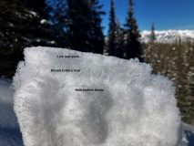
Snowpack: Less than an inch of new snow overnight preserved large grained surface hoar on the near and below treeline slopes that we visited. There was enough wind in exposed locations to destroy it.
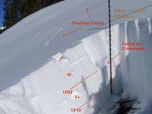
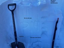
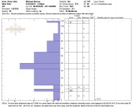
Still getting semi-frequent collapses below treeline and a few collapses near treeline. The latter triggered by second person on skin track or from hard stomps. The collapses didn’t produce much for shooting cracks, but judging off of how far away trees were shaking, it seems that most radiated less than 20 to 30 feet. This is a notable improvement from collapsing observed earlier in the week. We didn’t travel much near anything steep enough to avalanche; the few small test slopes below treeline that we stomped on didn’t produce any results. See attached photo for a profile at 10,600 feet, which produced moderate propagating results (ECTP14) 50 cm deep on 2 mm, fist hard facets.


Photos:

Read Full Observation
01/03/21

Elkton

Date of Observation: 01/03/2021
Name: Ben Pritchett


Zone: Northwest Mountains
Location: Elkton area
Aspect: South East, South, South West, West
Elevation: Near and Above Treeline


Avalanches: One tiny fresh wind slab off the Treasury to Galena ridge.
Weather: Ridgeline Wind Speed: 10-20 mph
Ridgeline Wind Direction: NW
Wind Loading: Previous
Temperature: 15 F
Sky Cover: Few
Weather Description: Clouds increased late morning through the afternoon. Light to moderate northwest winds.
Snowpack: Travelled over alpine south and southeast-facing slopes. Near treeline we travelled on east through south to west. No cracking or collapsing observed. A week ago on a similar route in the same terrain collapsing was common near treeline, but not above. Overnight northwest winds transported snow only near alpine ridgelines. Drifts were soft and posed no threat.

Photo caption: Northwest winds scoured windward alpine ridges and built soft fresh drifts. January 3, 2021.


Photos:

Read Full Observation
01/03/21

Irwin Obs

Date of Observation: 01/01/2021
Name: Mike Barney


Zone: Northwest Mountains
Location: below Round Two, Irwin
Aspect: West
Elevation: 11,100′


Avalanches: SS-AS-R1-D1-O 50 to 60cm deep, 50′ wide, and ran 150′ triggered on Friday (1/1/2021)
Weather: Light to Mod southwest winds scattered clouds and around 17F.
Snowpack: NTL west aspect- 50 to 110cm HS, with a pencil to knife hard mid-pack layer and about 25cm of depth hoar on the ground. BTL west aspect sheltered from the wind- 80cm HS with 4F- mid-pack and about 25cm of depth hoar at the base.


Photos:

Read Full Observation
The blog.