Kebler Pass Area

CBAC2014-15 Observations

NAME: Banks
DATE: 20140211
LOCATION: Kebler
ELEV: 9,400-12,300
ASPECT: SE-SW


WEATHER: Clear, Cool in am. Warm in pm. Overall mostly light to moderate winds from NE

AVALANCHE / SNOWPACK OBS: A recent Wet loose from the ridgeline (probably Tue 10th) on SE @ 12,100 ~40* 2 small collapses along ridgeline (SE & SW @~10*) on thin faceted snow pack covered by wind hardened snow. Skied up to 40* on SE-SW without incident. Below 10,850 on S-SW aspects ~15:00 snow was unsupportive wet facets/DH with ski pen ~20-30cm, boot pen 1/2 way to China. Flats & SE were more supportive

Mountain Weather February 11, 2015

CB Avalanche CenterWeather

Date: 02/11/2015

If you are looking for fresh powder, Monarch got 7″ and it is still snowing there. Drive east. The trough responsible for this snowfall is pushing south across the eastern part of the state, bringing upslope snowfall but leaving our Elk Mountains on the leeward and dry side of the storm. Mild and generally dry conditions will accompany the high pressure that builds into the Great Basin and over Colorado through the rest of the week.

Crested Butte Area

CB Avalanche Center2014-15 Observations

LOCATION: Crested Butte Area
DATE OF OBSERVATION: 02/10/2015
NAME: Zach Guy
SUBJECT: Crested Butte Area
ASPECT: North, North East
ELEVATION: 10,000 ft

AVALANCHES: No signs of instability

WEATHER: Broken skies. Calm winds. I counted 4 or 5 snowflakes falling from the sky.. But they were pretty big.

SNOWPACK: A profile on a NE aspect below treeline showed the Jan 11 surface hoar layer 25 cm deep, with fist hard, faceted snow above and below. No real slab over the surface hoar and no results on this layer, and we didn’t see any signs of instability on slopes up to 40 degrees.

Crested Butte Area

CBAC2014-15 Observations

NAME: Evan Ross
DATE: 2/10/15
LOCATION: Coney’s
ELEVATION: 9,900-10,900
ASPECT: NE


Weather: Partly cloudy sky in the Washington gulch area with plenty of sun and warm temps to soften snow on sunny slopes. Farther west cloud cover looked overcast. Light winds for the most part.

Snowpack: Wet, gloppy snow surface below 10,000ft on sunny slopes and even some shaded slopes. Higher up the snow surface was cooler and crusts from the last few days where noticeable on slopes that had a more eastern tilt to them. Found buried surface hoar down 40cm below a 1f slab in the starting zone of coneys. Found the SH mid way down the bowl too, about 30cm down. Skied the bowl with many other tracks and still no obvious sings to instability.

Mountain Weather February 10, 2015

CB Avalanche CenterWeather

Date: 02/10/2015

A band of moisture and a cool front is moving southward from Northern Colorado early this morning. As it passes over the Elk Mountain, we will hopefully see an inch or two or snow, but there could be convective component that brings localized heavier showers. The NOAA discussion this morning mentioned the threat of an isolated lightning strike. As if we don’t have enough concerns to deal with this time of year in the mountains. The trough retreats and closes off to our southwest on Wednesday, bringing upslope dynamics to our east and a faint chance for some light spill-over snowfall. High pressure returns under dry northwest flow for the remainder of the week, bringing back warmer than normal temperatures.

Skier triggered persistent slabs on Peeler Peak

CB Avalanche Center2014-15 Observations

LOCATION: Kebler Pass Area to CB Area
DATE: 02/09/2015
NAME: Zach Guy
SUBJECT: Skier triggered persistent slabs on Peeler Peak
ASPECT: North, North East, East, South
ELEVATION: 9,000-12,000 ft

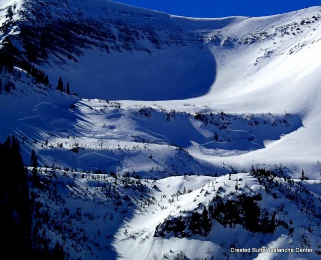
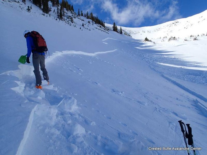
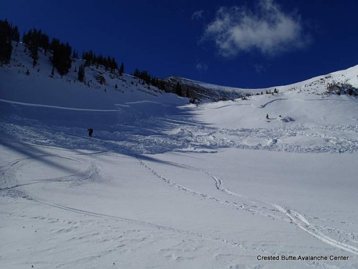
AVALANCHES: We skier triggered two persistent slab avalanches failing on the Jan 11 surface hoar layer, one of which sympathetically triggered another slide, on N to NE aspects near treeline on Peeler Peak. The slides were 1 to 1.5 feet deep. One failed 500 feet wide and sympathetically pulled out another slab about 200 feet away. They were on small features and ran roughly 150 vertical feet. SS-AS-R3-D1.5-O, SS-ASy-R1-D1-O, and SS-AS-R2-D1-O. Interesting notes: 1.) They were both triggered by the second skier from low on the slope, after the first skier had jumped around on the slopes attempting to trigger them. 2.) A large portion of the largest slide ran on slope angles below 35 degrees, with the slab pulling out on a slope as low as 20 degrees.

WEATHER: Calm to light winds, warm, few clouds.

SNOWPACK: South aspects: Multiple layers of wet crusts and facets to the ground on N/BTL slopes. As we approached ridgetop, there was ~3″ of wet recent snow that was easily sluffing on steep pitches.

North aspects above treeline: The slopes we observed were mostly wind scoured with large sastrugi features. A few crossloaded pockets. No signs of instability on steep slopes.

North – East aspects near treeline: Snow profiles on Peeler Peak and on Schuykill Ridge showed the Jan 11 surface hoar layer 35 – 40 cm deep, propagating in extended column tests (ECTP M, sudden collapse, Q1). Deeper weak layers were indistinct and unreactive in tests. See profiles

North-Northeast aspects below treeline: As we descended in elevation, the slab over SH lost cohesion due to faceting and was shallower in depth (<15 cm thick), and the surface hoar became spotty in distribution in semi-gladed terrain. The snowpack felt entirely faceted with the exception of a few isolated pockets of wind-stiffened snow.  Full trapdoor skiing at lowest elevations.  No signs of instability on steep slopes.

UPLOADS:

OLYMPUS DIGITAL CAMERA

OLYMPUS DIGITAL CAMERA
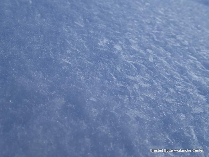
Bed surface with surface hoar still sitting on it.

OLYMPUS DIGITAL CAMERA

OLYMPUS DIGITAL CAMERA

crown profile

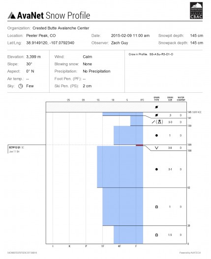
Crown profile, Peeler Peak.  North aspect NTL

schuykill

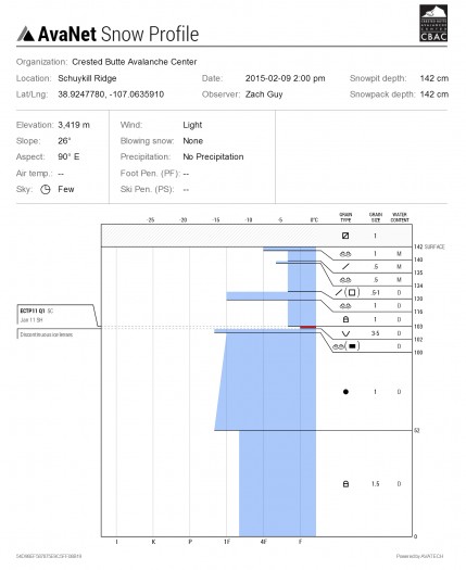
Profile on Schuykill Ridge, E aspect NTL


Gothic Area

CBAC2014-15 Observations

GUIDE(S): Havlick
DATE: 2/6-2/8
LOCATION: maroon hut/gothic
ASPECT: N-NE-E
Elevation: 9-10500


WEATHER: Mostly sunny skies, very warm temps, minimal wind. Did get a skiff of snow Saturday night. Crazy.

SNOWPACK/AVALANCHE OBS (approach flotation issues): We dug at edge of rock glacier in WNW side of whiterock up copper creek. HS Ranged from 80-200cm with widespread surface hoar 10-15mm preserved 20-40cm deep under a 4F slab. Dec 13th slab was unreactive until an informal extended deep tap got full propagation after wailing on it several times. Several natural avalanches were observed off center of e. Face of gothic and ene face of baldy from weds/thurs storm/wind. Spookiest results were on snodgrass. Preserved SH 10mm, ECTP7, ECTP12… Both SP, on 26*, E-facing slope. Deferred to lowest angle terrain and skied 30* meadow directly below saddle. 6th skier got large collapse on descent, but no cracking observed. Adjacent to our descent, on Friday, 2 skiers looked to have remotely triggered a 100-150ft wide pocket, 12-18″ deep, that looked like a SH weak layer from a distance. Below treeline, slightly convex meadow.

Schuykill Ridge

CB Avalanche Center2014-15 Observations

LOCATION: Crested Butte Area
DATE OF OBSERVATION: 02/08/2015
NAME: Zoe Smith, Nick Schley, Tucker Cocchiarella, & Sam Lesnikoski
SUBJECT: Schuykill Ridge
ASPECT: North, South West
WEATHER: Warm: 0+ degrees C, No wind at Ridgetop, No clouds.


SNOWPACK: Location: 30 Degrees N, 12:20, 28 degree slope: ECTP #5 SC Q1. Fracture 35cm down on a buried surface hoar (3-5mm) 148cm HS. Slab on top (4f) on BSH Slab below (fist). Isolated column above and resulted on the same layer with skier weight.

UPLOADS:

Snowpit

Anthracite Range

CB Avalanche Center2014-15 Observations

LOCATION: Kebler Pass Area
DATE OF OBSERVATION: 02/09/2015
NAME: Evan Ross
SUBJECT: Anthracite Range
ASPECT: North, North East, West, North West
ELEVATION: 10,300-12,300

WEATHER: Mostly cloudy in the morning before becoming clear by 10am. Light wind with moderate gusts at ridgeline.

SNOWPACK: Wet snow surface to varying depths below 10,500ft, in relatively thick trees and on all aspects observed. Snow surfaces just above treeline where heavy wind effected and generally hard wind pressed slabs. Along the way I found buried SH 30-50cm deep every time I dug into the snow. Obviously these were targeted and ended up being a , below treeline slope on a west aspect and at near treeline elevations on north and northwest aspects. At 11,600ft with a wind affected snow surface on a north aspect ,the SH was 35cm deep sandwiched between 1f slabs. Test results on this interface where CTM SC and ECTP19 SC. Even with these results we didn’t observe any collapse while traveling through the terrain. We either didn’t find the right spot on the slope, I need to eat more cinnamon rolls and pack on some pounds, or we need a big snow storm to make this interface more active in the area we traveled.