


CBAC forecaster takes a quick look at the crown of a skier triggered avalanche off of Peeler Peak, which broke on a layer of buried surface hoar.
Skier triggered persistent slabs on Peeler Peak
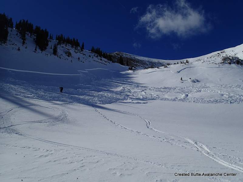
LOCATION: Kebler Pass Area to CB Area
DATE: 02/09/2015
NAME: Zach Guy
DATE: 02/09/2015
NAME: Zach Guy
SUBJECT: Skier triggered persistent slabs on Peeler Peak
ASPECT: North, North East, East, South
ELEVATION: 9,000-12,000 ft
ASPECT: North, North East, East, South
ELEVATION: 9,000-12,000 ft
AVALANCHES: We skier triggered two persistent slab avalanches failing on the Jan 11 surface hoar layer, one of which sympathetically triggered another slide, on N to NE aspects near treeline on Peeler Peak. The slides were 1 to 1.5 feet deep. One failed 500 feet wide and sympathetically pulled out another slab about 200 feet away. They were on small features and ran roughly 150 vertical feet. SS-AS-R3-D1.5-O, SS-ASy-R1-D1-O, and SS-AS-R2-D1-O. Interesting notes: 1.) They were both triggered by the second skier from low on the slope, after the first skier had jumped around on the slopes attempting to trigger them. 2.) A large portion of the largest slide ran on slope angles below 35 degrees, with the slab pulling out on a slope as low as 20 degrees.
WEATHER: Calm to light winds, warm, few clouds.
SNOWPACK: South aspects: Multiple layers of wet crusts and facets to the ground on N/BTL slopes. As we approached ridgetop, there was ~3″ of wet recent snow that was easily sluffing on steep pitches.
North aspects above treeline: The slopes we observed were mostly wind scoured with large sastrugi features. A few crossloaded pockets. No signs of instability on steep slopes.
North – East aspects near treeline: Snow profiles on Peeler Peak and on Schuykill Ridge showed the Jan 11 surface hoar layer 35 – 40 cm deep, propagating in extended column tests (ECTP M, sudden collapse, Q1). Deeper weak layers were indistinct and unreactive in tests. See profiles
North-Northeast aspects below treeline: As we descended in elevation, the slab over SH lost cohesion due to faceting and was shallower in depth (<15 cm thick), and the surface hoar became spotty in distribution in semi-gladed terrain. The snowpack felt entirely faceted with the exception of a few isolated pockets of wind-stiffened snow. Full trapdoor skiing at lowest elevations. No signs of instability on steep slopes.
UPLOADS:

 Bed surface with surface hoar still sitting on it.


Crown profile, Peeler Peak. North aspect NTL

Profile on Schuykill Ridge, E aspect NTL
Gothic Area
GUIDE(S): Havlick
DATE: 2/6-2/8
LOCATION: maroon hut/gothic
DATE: 2/6-2/8
LOCATION: maroon hut/gothic
ASPECT: N-NE-E
Elevation: 9-10500
Elevation: 9-10500
WEATHER: Mostly sunny skies, very warm temps, minimal wind. Did get a skiff of snow Saturday night. Crazy.
SNOWPACK/AVALANCHE OBS (approach flotation issues): We dug at edge of rock glacier in WNW side of whiterock up copper creek. HS Ranged from 80-200cm with widespread surface hoar 10-15mm preserved 20-40cm deep under a 4F slab. Dec 13th slab was unreactive until an informal extended deep tap got full propagation after wailing on it several times. Several natural avalanches were observed off center of e. Face of gothic and ene face of baldy from weds/thurs storm/wind. Spookiest results were on snodgrass. Preserved SH 10mm, ECTP7, ECTP12… Both SP, on 26*, E-facing slope. Deferred to lowest angle terrain and skied 30* meadow directly below saddle. 6th skier got large collapse on descent, but no cracking observed. Adjacent to our descent, on Friday, 2 skiers looked to have remotely triggered a 100-150ft wide pocket, 12-18″ deep, that looked like a SH weak layer from a distance. Below treeline, slightly convex meadow.
Schuykill Ridge
LOCATION: Crested Butte Area
DATE OF OBSERVATION: 02/08/2015
NAME: Zoe Smith, Nick Schley, Tucker Cocchiarella, & Sam Lesnikoski
DATE OF OBSERVATION: 02/08/2015
NAME: Zoe Smith, Nick Schley, Tucker Cocchiarella, & Sam Lesnikoski
SUBJECT: Schuykill Ridge
ASPECT: North, South West
WEATHER: Warm: 0+ degrees C, No wind at Ridgetop, No clouds.
ASPECT: North, South West
WEATHER: Warm: 0+ degrees C, No wind at Ridgetop, No clouds.
SNOWPACK: Location: 30 Degrees N, 12:20, 28 degree slope: ECTP #5 SC Q1. Fracture 35cm down on a buried surface hoar (3-5mm) 148cm HS. Slab on top (4f) on BSH Slab below (fist). Isolated column above and resulted on the same layer with skier weight.
UPLOADS:

Snowpit
Anthracite Range
LOCATION: Kebler Pass Area
DATE OF OBSERVATION: 02/09/2015
NAME: Evan Ross
DATE OF OBSERVATION: 02/09/2015
NAME: Evan Ross
SUBJECT: Anthracite Range
ASPECT: North, North East, West, North West
ELEVATION: 10,300-12,300
ASPECT: North, North East, West, North West
ELEVATION: 10,300-12,300
WEATHER: Mostly cloudy in the morning before becoming clear by 10am. Light wind with moderate gusts at ridgeline.
SNOWPACK: Wet snow surface to varying depths below 10,500ft, in relatively thick trees and on all aspects observed. Snow surfaces just above treeline where heavy wind effected and generally hard wind pressed slabs. Along the way I found buried SH 30-50cm deep every time I dug into the snow. Obviously these were targeted and ended up being a , below treeline slope on a west aspect and at near treeline elevations on north and northwest aspects. At 11,600ft with a wind affected snow surface on a north aspect ,the SH was 35cm deep sandwiched between 1f slabs. Test results on this interface where CTM SC and ECTP19 SC. Even with these results we didn’t observe any collapse while traveling through the terrain. We either didn’t find the right spot on the slope, I need to eat more cinnamon rolls and pack on some pounds, or we need a big snow storm to make this interface more active in the area we traveled.
Warm Day at Evans Basin
LOCATION: Kebler Pass Area
DATE OF OBSERVATION: 02/09/2015
NAME: Dustin Eldridge
DATE OF OBSERVATION: 02/09/2015
NAME: Dustin Eldridge
SUBJECT: Warm Day at Evans Basin
ASPECT: North, North East, East, South East
ELEVATION: 9000-11500
ASPECT: North, North East, East, South East
ELEVATION: 9000-11500
AVALANCHES: Saw a small point release or two (R1 D1) from trees and rock bands.
WEATHER: Hot! Gusty W winds on ridgetops, hardly noticeable elsewhere. Clouds slowly built throughout the day.
SNOWPACK: Just about anything you can imagine. On a small lee slope near TL I found everything from a supportive melted crust on more E-facing slopes and non supportive full depth facets on N-facing slopes that were sheltered from the wind. Slopes in between were supportive and showcased a nice surface hoar layer around 3-4 inches from the snow surface. Produced a clean Q1 shear on some baby burping. (Isolate a column and toss it up and down lightly). Snowpack was around 120 cm and deeper with some spots so supportive that I couldn’t push a pole through (these were more N-facing but likely benefited from the wind).
UPLOADS:
Mountain Weather February 9, 2015
Date: 02/09/2015
The blocking ridge of high pressure that is responsible for the dry weather pattern we’ve been in is under attack by two small weather systems that will bring a change in weather for us mid week. This evening a weak trough will work its way into northern Colorado and bring us light accumulations on Tuesday. Then another system will dig further south into Colorado Tuesday evening or Wednesday. This 2nd system looks a little better but will be strongest to our east along the Continental Divide. Later in the weak the blocking ridge looks to rebuild, putting us back under dry northwest flow.
Today
High Temperature: 36
Wind Speed: 10-20
Wind Direction: SW
Sky Cover: Increasing clouds
Snow: 0
Tonight
Low Temperature: 25
Wind Speed: 5-15
Wind Direction: SW
Sky Cover: Partly Cloudy
Snow: 0
Tomorrow
High Temperature: 34
Wind Speed: 5-15
Wind Direction: W
Sky Cover: Mostly Cloudy
Snow: 0-2
Washington Gulch
LOCATION: Crested Butte Area
DATE OF OBSERVATION: 02/08/2015
NAME: Zach Guy
DATE OF OBSERVATION: 02/08/2015
NAME: Zach Guy
SUBJECT: Washington Gulch
ASPECT: North East
ELEVATION: 9,900 ft
ASPECT: North East
ELEVATION: 9,900 ft
AVALANCHES: None.
WEATHER: Warm, clear, no wind.
SNOWPACK: Low angle south aspects held wet grains/ wet facets to the ground. Isothermal snowpack, 50 cm deep or less. Ski pen was nearly to the ground.
North and northeast aspects held entirely faceted snowpack, with about 2-4″ of DF at the surface. Boot pen to the ground, ski pen nearly to the ground. Melt-freeze crusts formed as far as 70* ENE aspect on steep slopes. Further north still dry.
I dug a pit below a heavily windloaded ridgeline, NTL type of snowpack. The new persistent slab over Jan 30th facet layer is 20 cm thick, and was unreactive in the pit, but produced localized cracking about 5 feet wide. The December 13th facet layer was 40 cm deep under a 1F slab, still propagating under moderate loading steps (ECTP15), and the depth hoar failed while isolating the column but this wasn’t a repeatable result, about 100 cm deep. This structure was isolated to just below ridgeline. About 20 yards downslope, it abruptly changed to fully faceted snowpack, with now persistent slab concerns.
UPLOADS:
 Presentation1
 profile
Mountain Weather February 8, 2015
Date: 02/08/2015
The blocking ridge of high pressure appears to continue through this week. Keeping the storm track to our north and leaving most of Colorado dry. There will be a few small disturbances that move through during this period, bringing increased cloudiness and a chance for small accumulations of snow. We’d like to say 0-14” of snow during these shortwaves, but unfortunately our confidences is highest at the 0” level. This morning clouds should be clearing with continued mild temperatures. These shorwaves will arrive Monday morning and again on Tuesday afternoon through Wednesday.
Today
High Temperature: 37
Wind Speed: 5-15
Wind Direction: W, NW
Sky Cover: Decreasing clouds
Snow: 0-trace
Tonight
Low Temperature: 25
Wind Speed: 2-12
Wind Direction: W
Sky Cover: Clear
Snow: 0
Tomorrow
High Temperature: 36
Wind Speed: 5-15
Wind Direction: SW, W
Sky Cover: Partly Cloudy
Snow: 0
Gothic Temps
Date: 2.7.15
Name: billy bar
Location: Gothic
Up until yesterday the earliest date in which the temperature in Gothic climbed above 10ºC (50ºF) was March 06. Yesterday it reached 52ºF- beating that old date by full month.