South side of Baldy

CB Avalanche Center2019-20 Observations

Location: Paradise Divide Area
Date of Observation: 03/24/2020
Name: Zach Kinler
Aspect: East, South East, South, South West, West
Elevation: 10,500′-12,000′
Avalanches:

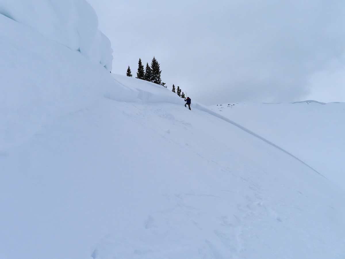
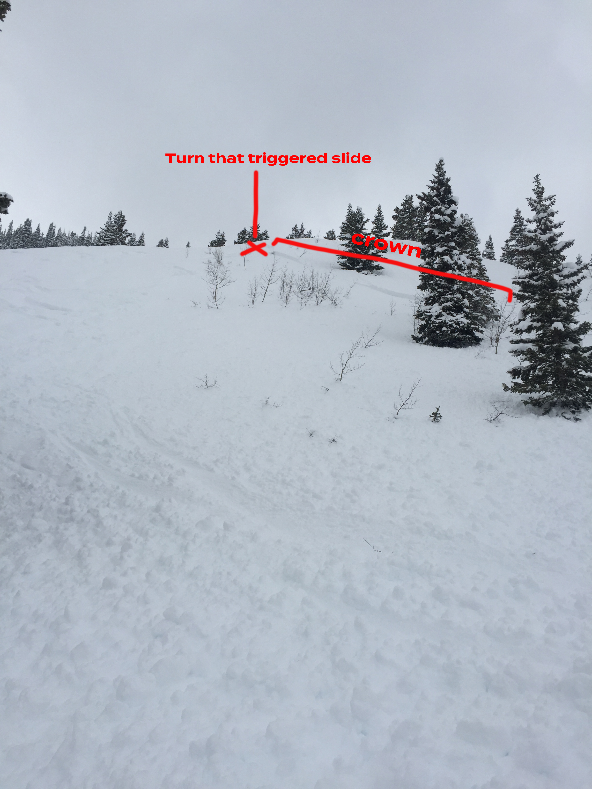
No new avalanches observed

Weather: Pleasant day, Partly Cloudy skies, temperatures warming to near freezing. Calm to light breezes in sheltered areas with Light to moderate westerly wind near tree line.

Snowpack: 5″ new snow around 11K. Up to 11,500′ this snow became moist on the southern half of the compass. Above 11,500′ surfaces were mostly dry with increasing westerly winds transporting snow onto easterly aspects. Small drifted terrain features had deposits up to a foot deep with cracking from skis traveling 10-20 feet. Last week’s crust was around 60 cm below the surface. Avoided larger drifted features in this terrain. Once below 11,500′ warming surfaces limited available snow for transport with similar slopes producing no instabilities. Winds increased after 16:00 with moving snow visible on the highest peaks.

East aspect 11,800′

Moderate westerly winds were transporting snow onto leeward aspects

Winds increased by late in the afternoon moving available recent snow

Gothic 7am Weather Update

CB Avalanche Center2019-20 Observations

Location: Paradise Divide Area
Date of Observation: 03/24/2020
Name: billy barr
Subject: Gothic 7am Weather Update

Weather: cloudy and mild with light snow, mostly in the few hours after dark with stronger wind into the night but then letting up by 9 p.m. Total 24 hour snow was 4½” with 0.35″ of water. Snow pack is at 54½” and holding somewhat steady. Currently overcast and calm with the temp. 22F, the low of the day.

Mountain Weather for 11,000ft. Tuesday 3/24

CB Avalanche CenterWeather

Date: 03/24/2020

Well, the storm came, now it is going, and what happened in between? Not a lot. At 5am this morning we are currently looking at 3.8 centimeters of new snow!! That sounds a lot better than 1.5 inches. The upper atmosphere has dried out, but we still have low-level residual moisture hanging out. So we should continue seeing some light snow this morning before the sky becomes more partly cloudy later today. The cloud forecast is a bit uncertain with the low-level moisture is going to play out.

Looking at the rest of the week. we stay on the dry side of the line until Thursday, but again we will see some flakes here and there as it looks like we’ll continue to have some low-level moisture about. The big change coming up will be the wind. A strong 150kt jet moves overhead tonight as we look ahead to a windy midweek. The alpine is going to get blown, and we’ll also see some strong winds mixing down to lower elevations.

Another low-pressure system will be moving across the desert southwest later this week and line up as our next storm. Snow will probably begin with that storm late on Thursday.

  • Today

    High Temperature: 33 to 37
    Winds/Direction: 10 to 20/SW
    Sky Cover: Partly Cloudy
    Irwin Snow: 0 to 1
    Elkton Snow: 0 to 1
    Friend’s Hut Snow: 0 to 1

  • Tonight

    Low Temperature: 22 to 26
    Winds/Direction: 12 to 22 G45, WSW
    Sky Cover: Partly Cloudy
    Irwin Snow: 0 to 1
    Elkton Snow: 0 to 1
    Friend’s Hut Snow: 0 to 1

  • Tomorrow

    High Temperature: 33 to 37
    Winds/Direction: 10 to 20 G40, WSW
    Sky Cover: Partly Cloudy
    Irwin Snow: 0 to 1
    Elkton Snow: 0 to 1
    Friend’s Hut Snow: 0 to 1

Mt Emmons Avalanche Visit

CB Avalanche Center2019-20 Observations

Location: Crested Butte Area
Date of Observation: 03/23/2020
Name: Evan Ross, Zach Kinler
Subject: Mt Emmons Avalanche Visit
Aspect: North East, East
Elevation: 11,800ft

Avalanches: This avalanche is estimated to have released on the morning of 3/22, during a period of intense wind-loading and a pulse of high precipitation rates. The subtle aspect changes along the crown varied from NE to E and the snowpack structure was notably different between those changes. The avalanche was small for the terrain (R1) and large in destructive size (D2), therefore capable of burying a person. We spend our time on the deepest section of crown. The crown in that area average 60cm and was up to 125cm tall. The avalanche failed on-top of two separate crusts. Those crusts were each 2cm thick with the upper being Pencil hard and the lower 1F hard. Where there was the most wind-loading the avalanche failed on the deeper crust, lower on the ridge where there was less wind-loading the avalanche failed on the upper crust. Both of those crusts had 1.5mm facets on top and 1 mm facets below. Those facets were not particularly weak and didn’t produce results in ECT or PST tests from two separate locations along the crown. On the more NE tilted portions of the crown, the crusts faded away, but a thin layer of small rounding facets could still be found. The slope angle near the crown averaged in the upper 30’s and rolled over steeper lower on the slope.

There were some cracks in lower angled sections of the slope above the crown. Though of interest, there were no shooting cracks past the flanks of the avalanche or lower in the bowl where the avalanche debris passed through and came to a rest. The flanks of the avalanche noticeably decreased lower on the slope and below the previous wind-loading.

Mountain Weather for 11,000ft. Monday 3/23

CB Avalanche CenterWeather

Date: 03/23/2020

Monday starts off with a period that we may have few clouds, as clouds that have been pushed in on southwesterly flow decrease, and we await the next storm arriving this afternoon. A small storm is moving across Nevada this morning. We’ll see increasing cloud cover today ahead of that storm, with precipitation starting in the afternoon. A general 4 to 8” of snow accumulating by tomorrow still looks about right. There is a chance we could see some heavy snow showers if we luck out with a piece of good convection passing overhead late this afternoon or this evening.

We are also going to see continued winds with the southern jet stream passing overhead and upper elevation gusts in the 45 to 55 MPH range.

We have some drier air aloft moving overhead for Tuesday, then we’ll land in unsettled weather for the remainder of the week. The next good looking storm arrives around Friday.

  • Today

    High Temperature: 30 to 34
    Winds/Direction: 10 to 20/SW
    Sky Cover: Mostly Cloudy
    Irwin Snow: 2 to 4pm
    Elkton Snow: 2 to 4pm
    Friend’s Hut Snow: 2 to 4pm

  • Tonight

    Low Temperature: 18 to 22
    Winds/Direction: 12 to 22/W
    Sky Cover: Overcast
    Irwin Snow: 3 to 5
    Elkton Snow: 3 to 5
    Friend’s Hut Snow: 2 to 4

  • Tomorrow

    High Temperature: 31 to 35
    Winds/Direction: 12 to 22 G30, WSW
    Sky Cover: Partly Cloudy
    Irwin Snow: 0 to 1
    Elkton Snow: 0 to 1
    Friend’s Hut Snow: 0 to 1

Gothic Mountain Avalanches

CB Avalanche Center2019-20 Observations

Location: Paradise Divide Area
Date of Observation: 03/22/2020
Name: Evan Ross
Subject: Gothic Mountain Avalanches
Aspect: East
Elevation: Above Treeline

Avalanches: This picture tells a really cool story about avalanches and you can definitely look at it for some time. Many old sluffs had run through the terrain without triggering much for avalanches. Then during a period of intense loading Tuesday morning, natural Wind Slab Avalanches started to run and thoughts further stepped down to the 3/18 interface. At least one of these become very large in size.

Photo: David Scheefer

Kebler Pass

CB Avalanche Center2019-20 Observations

Location: Kebler Pass Area
Date of Observation: 03/22/2020
Name: Zach Kinler
Aspect: North, North East, East, South East
Elevation: 10,200′-11,400′
Avalanches:
Axtel NE 11,600′ D1.5 Wind Slab
Anthracite Range E 11,400′ D1.5 Wind Slab, likely ran 3/20 or 3/21
Elk Basin SE 11,600′ 4 X D1.5 Wet Loose

Weather: Partly to Mostly Cloudy skies with pleasant temperatures, warm in the sun, cool in the shade. Light to moderate westerly breeze, temps near freezing.

Snowpack: Wind was transporting snow on peaks and ridgelines at times throughout the day. North aspect 10,600′ had 60 cm(2 ft) of settled snow since 3/19. Previous crusts were not felt until you moved onto Northeast aspects where they were observed at 60 cm(3/19) and 80 cm. East aspects below 10,500′ had a thin surface crust by end of the day. No signs of instability while skiing E-N aspects up to 40 degrees in sheltered terrain. Southerly aspects were moistened and had refrozen into a soft 3 cm crust by 16:00.

Axtel NE 11,600′

Anthracite Range, E 11,400′

Elk Basin, 11,600′ SE

Old Slabs And Sluffs In The Slate

CB Avalanche Center2019-20 Observations

Location: Paradise Divide Area
Date of Observation: 03/22/2020
Name: Evan Ross
Subject: Old Slabs And Sluffs In The Slate
Aspect: North, North East, East, South East
Elevation: 9,500-11,500
Avalanches: Several old avalanches with more details in pictures.

Weather: Southwest to West winds peaked with some intense loading and high snowfall rates this morning as the shortwave was moving out. That loading period lead to several natural avalanches in other observations. By noon the sky cover had started to decreas. Mostly cloudy sky held for the ruby range while less cloud clover apreaded to be down valley. Winds were light were I toured but moderate loading on upper elevation ridgelines and peaks continued through the day. After the peak precip S-1 snowfall continued into the early PM hours.

Snowpack: I went hunting and didn’t find too much for concern. I did back off from climbing through one wind-loaded terrain feature but that was about it. In general, hand pits continued to identify non-persistent storm instabilities in the upper snowpack, and beyond that, those showed no signs of instability. While traveling on the NE to E to SE slopes, 8 out of 10 attempts to find a result on the 3/18 interface showed good bonding at the interface with no concern. While considering climbing through a NE wind-loaded terrain feature at 11,600ft, a quick hand pit reviled a concerning soft crust with a thin layer of weaker faceted snow below. Digging just downslope in a safer area, the same interface was found 75cm’s down. Though the weakness below the crust was not quite as pronounced. A thicker layer of grouple was about 85cm down. ECT results didn’t produce any propagating results on either of those interfaces or in the storm interfaces higher up in the snowpack.

We had to hold a fairly strong north tilt to slopes if we wanted to avoid crust that formed yesterday morning on NE. Ski pen on northerly facing slopes was about 35cm, by the time you hit ESE ski pen was only about 5cm.

Red Lady Bowl

CB Avalanche Center2019-20 Observations

Location: Crested Butte Area
Date of Observation: 03/22/2020
Name: Frank Stern
Subject: Red Lady Bowl
Aspect: East
Elevation: 11,500

Avalanches: East side of Red Lady Bowl. Crown right below the skin track on the ridge at tree line. Crown might be 2 meters in spots, appears to have stepped down. Ran to bottom of bowl.

CBAC Note: This Wind Slab, potentially realizing at the 3/18 interface, appears to have stacked up to a Storm Slab that was reported yesterday in this flat-light photo.

Weather: Snowy/sunny, wind from west.
Snowpack: 12″wish in past three days, slope that slid was getting substantial deposition.

Snodgrass Avalanche

CB Avalanche Center2019-20 Observations

Location: Crested Butte Area
Date of Observation: 03/22/2020
Subject: Snodgrass Avalanche
Aspect: North East, East
Elevation: 10,400

Avalanches: R1, D1. Skier triggered a small slide on an ENE rollover on Snodgrass Mountain in the First Bowl area and was not caught in the slide. Slope angle around 35–38°. Crown varied from about 12″ deep to a couple inches. Crown was 50–70 feet wide, propagating skier’s left on the east-facing side of the gulley. Did not propagate skier’s right where other skiers had previously put down tracks, likely the day before. Avalanche ran about 100-150 feet until it stopped just before where the terrain became flat. Not enough snow to bury, but could have carried someone into the trees shown in the avalanche path, or potentially into the trees at the flat area at the bottom of the path. The storm snow slid on the older, firmer base layer and did not step down below the storm layer.

Weather: high-20’s to just below freezing around time of slide. Overcast all day with a few very brief breaks in the clouds but no full-on sun. Some scattered, very light snow with less than an inch of accumulation from 10 am to 3 pm.

Snowpack: North-facing trees on Snodgrass from 11,100′ to about 10,500′ had 1-2 feet of light, low-density fresh snow on top of a firm, supportive base. Storm snow in north-facing, higher-elevation trees showed no signs of cracking, whoomphing, or propagation. More open / less treed ENE slope that was triggered had about a foot of snow that was more sun-affected and dense than in the higher-elevation, North-facing trees. No signs of instability until skier triggered the slide.