Snodgrass Avalanche

CB Avalanche Center2019-20 Observations

Location: Crested Butte Area
Date of Observation: 03/22/2020
Subject: Snodgrass Avalanche
Aspect: North East, East
Elevation: 10,400

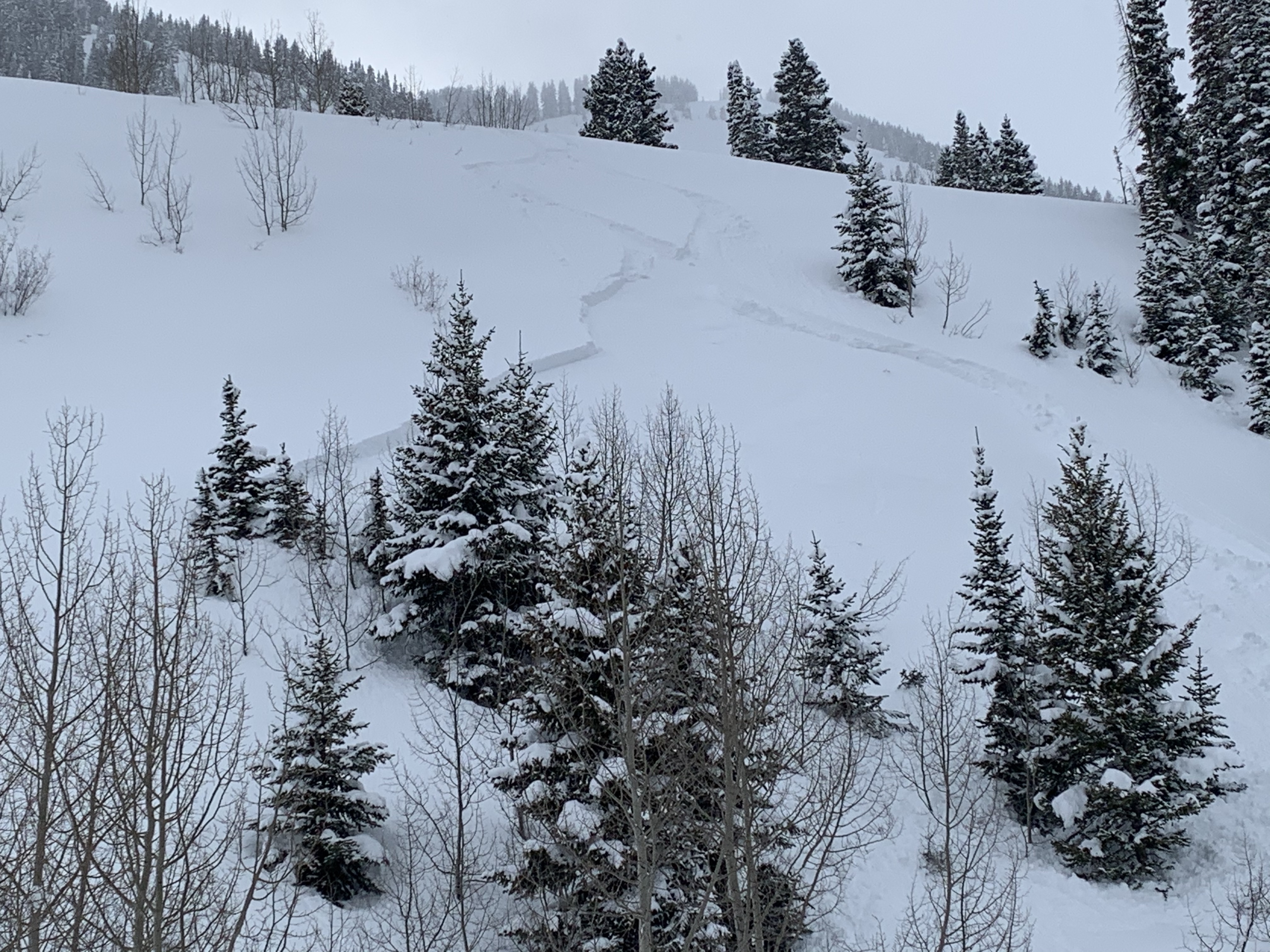
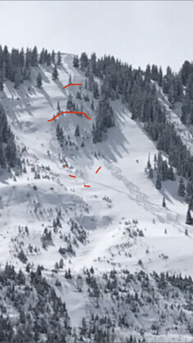
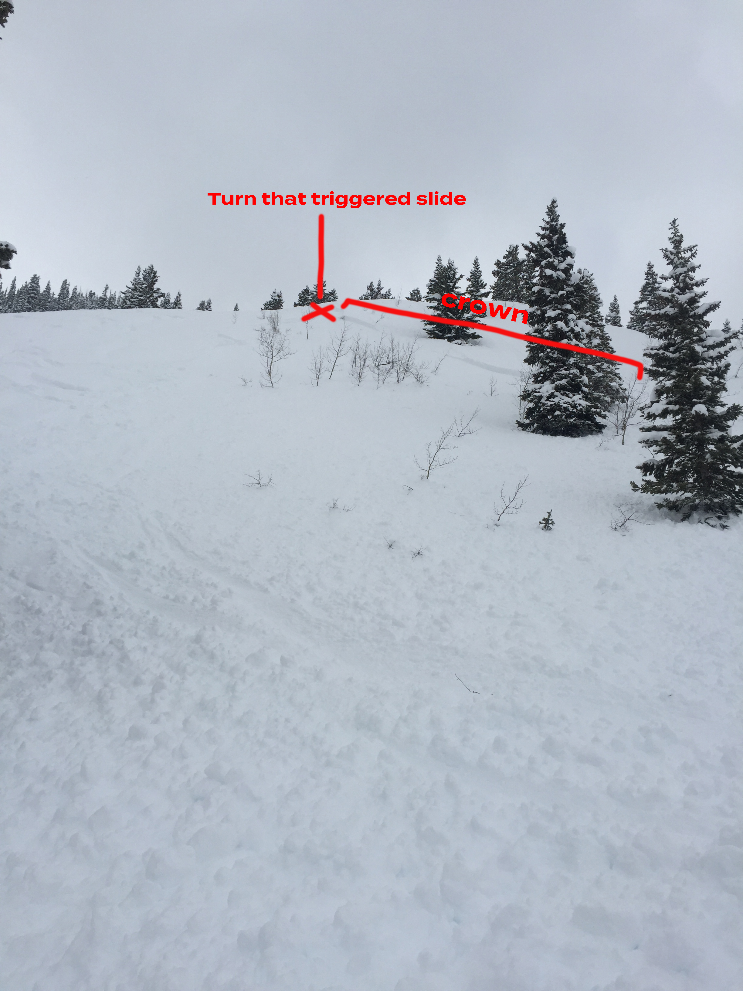
Avalanches: R1, D1. Skier triggered a small slide on an ENE rollover on Snodgrass Mountain in the First Bowl area and was not caught in the slide. Slope angle around 35–38°. Crown varied from about 12″ deep to a couple inches. Crown was 50–70 feet wide, propagating skier’s left on the east-facing side of the gulley. Did not propagate skier’s right where other skiers had previously put down tracks, likely the day before. Avalanche ran about 100-150 feet until it stopped just before where the terrain became flat. Not enough snow to bury, but could have carried someone into the trees shown in the avalanche path, or potentially into the trees at the flat area at the bottom of the path. The storm snow slid on the older, firmer base layer and did not step down below the storm layer.

Weather: high-20’s to just below freezing around time of slide. Overcast all day with a few very brief breaks in the clouds but no full-on sun. Some scattered, very light snow with less than an inch of accumulation from 10 am to 3 pm.

Snowpack: North-facing trees on Snodgrass from 11,100′ to about 10,500′ had 1-2 feet of light, low-density fresh snow on top of a firm, supportive base. Storm snow in north-facing, higher-elevation trees showed no signs of cracking, whoomphing, or propagation. More open / less treed ENE slope that was triggered had about a foot of snow that was more sun-affected and dense than in the higher-elevation, North-facing trees. No signs of instability until skier triggered the slide.
Skookadooks

CB Avalanche Center2019-20 Observations

Location: Paradise Divide Area
Date of Observation: 03/21/2020
Name: Chris Martin
Subject: Skookadooks
Aspect: North, North East, East
Elevation: 9,100-11,400

Avalanches: Small – medium size sluffs BTL/NTL in steep terrain.
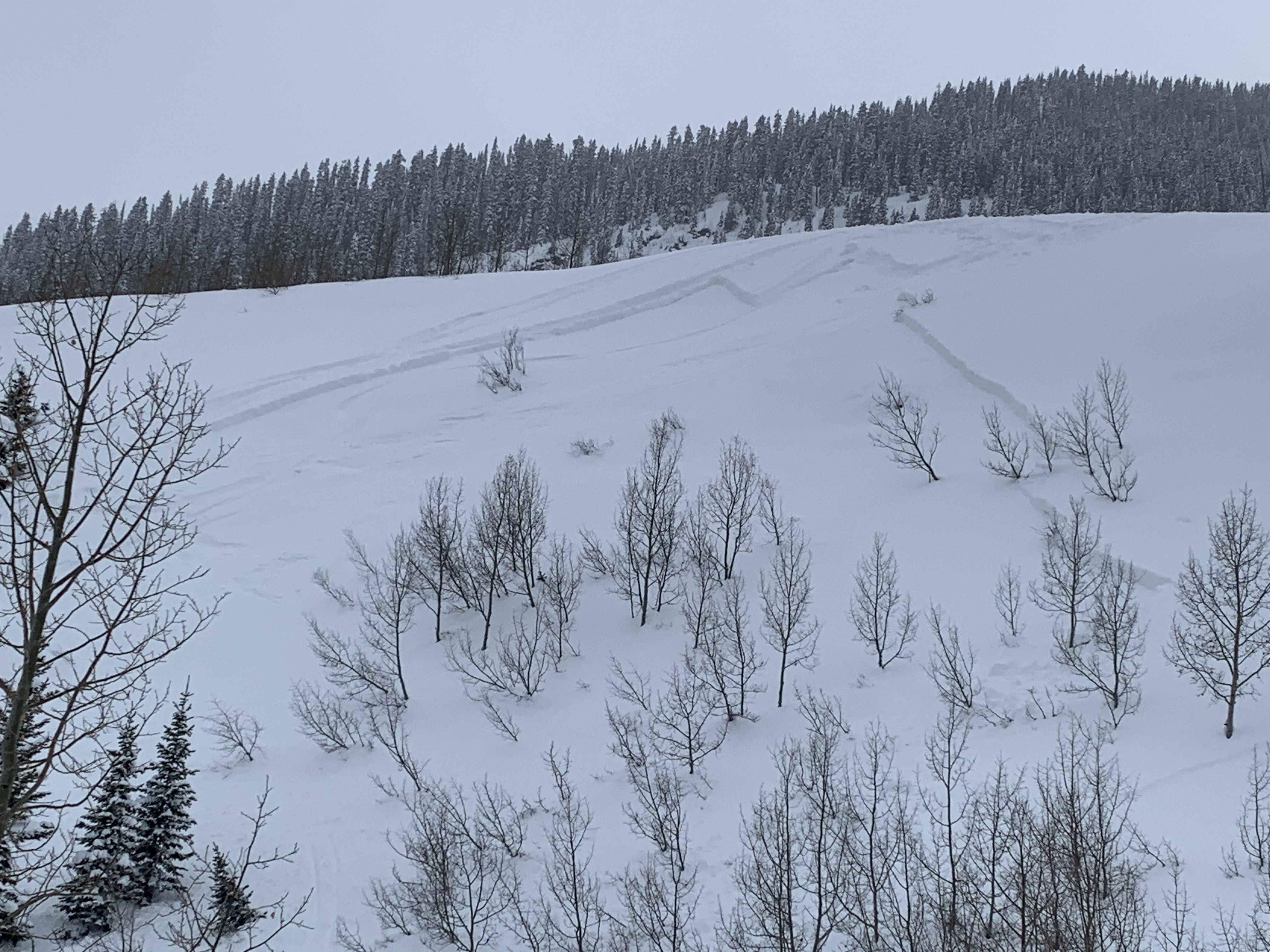
Two fresh small slabs D1.5-D2, on a ENE facing slope around 9500′. Skier trigger, 2nd on slope triggered 3/4 of the way down for each release.

Weather: Warmer temps down low. Snow and and intermittent sunshine throughout the day.

Snowpack: Slabs seemed to be releasing on a stout Mf/Cr. Steep slope, didn’t get angle or slab depth but ill guess 12″+.

Gothic 7am Update

CB Avalanche Center2019-20 Observations

Location: Kebler Pass Area
Date of Observation: 03/22/2020
Name: billy barr
Subject: Gothic 7am Update

Weather: Cloudy all Saturday but only a few brief snow showers. Then snow from about 4-6 a.m. this morning but light with strong wind gusts so 1″ new and 0.06″ water. Snowpack at 53½”. Now cloudy and windy with light, driven snow. Another nasty day. Low was 22F and currently 25 after a high of 36F yesterday. Unpleasant is a very nice way to describe the weather, though as of sunset last night the snowpack was just 9% below average for the date, but that was mostly that the recent snow is just started to settle.

Cement Creek

CB Avalanche Center2019-20 Observations

Location: Cement Creek Area
Date of Observation: 03/22/2020
Name: Cosmo
Subject: Cement Creek
Elevation: 9300

Weather: Snowing lightly @ 7am. 1” on the ground so far.

MOUNTAIN WEATHER FOR 11,000FT. Sunday 3/22

CB Avalanche CenterWeather

Date: 03/22/2020

The brief summary; small or quick storms keep moving through our area today, Monday, and later in the week. This is going to keep snow surfaces fresh and riding quality high. Yea baby.

A shortwave is currently moving across central and northern Colorado this morning. We’ll see snow showers during the AM hours, then drying in the PM hours today. Looks like we could have a nice, late afternoon, on our hands with partly cloudy sky. Unfortunately, we are starting to catch the edge of increased upper-level winds. Alpine weather stations are showing an increase in the wind this morning and look to remain in the 15 to 25mph range with some stronger gusts.

Dry weather continues overnight and into Monday morning. The next storm will bring increasing clouds on Monday with precipitation starting in the afternoon. By Tuesday morning we are looking at those snow accumulations stacking up in the 4 to 8” range. I’ll take it.

Dryer westerly flow sets up for Tuesday before more unsettled weather returns for the 2nd half of the week.

  • Today

    High Temperature: 30 to 34
    Winds/Direction: 8 to 18/W
    Sky Cover: Increasing clouds
    Irwin Snow: 1 to 3
    Elkton Snow: 1 to 3
    Friend’s Hut Snow: 0 to 2

  • Tonight

    Low Temperature: 14 to 18
    Winds/Direction: 5 to 15/SW
    Sky Cover: Mostly Clear
    Irwin Snow: 0
    Elkton Snow: 0
    Friend’s Hut Snow: 0

  • Tomorrow

    High Temperature: 30 to 34
    Winds/Direction: 10 to 20/SW
    Sky Cover: Mostly Cloudy
    Irwin Snow: 3 to 5PM
    Elkton Snow: 3 to 5PM
    Friend’s Hut Snow: 2 to 4PM

Elkton area obs

CB Avalanche Center2019-20 Observations

Location: Paradise Divide Area
Date of Observation: 03/21/2020
Name: Eric Murrow
Subject: Elkton area obs
Aspect: North East, East, South East, South, South West, West
Elevation: 9400′ – 11700′

Avalanches:Visbility was obscured for much of the day but had a few glimpses into near and above treeline terrain and observed just one avalanche that I would guess failed maybe on Friday on a drifted near treeline slope the faces northeast. Looked to be about D1.5 on a very drifty feature below a cornice.

Weather: Mostly cloudy skies after about 10am with on and off snow showers. The sun was often visible through the cloud cover and green-housing was felt multiple times during the day. New snow accumulation during the day through 330pm was about 2 inches. A brief period of sunshine early in the morning shortly after sunrise was enough to moisten the snow surface on slopes with any exposure to the sun including northeast.

Snowpack: Poked a number of holes on northeast, east, southeast, south, southwest, and west-facing slopes between 10,000 and 11,700 feet. Settled storm snow was generally in the 20 to 24 inch range. At a location with 22″ of storm snow I measured 1.9″SWE at noon.

On slopes that faced east through south through west, I found the storm snow was bonding much better than the day prior. CT’s, ECT’s, and hasty hand shears were not able to produce any results on top of the crust sitting below the storm snow. I made several attempts to identify faceted grains but couldn’t. The slab appears to be bonding reasonably well. No cracking was observed.  Southeast through south through west slopes had crusts strong enough carry the current new burden. East facing slopes around 11,000′ had a thinner crust but there were frozen ice columns beneath for several inches. East and southeast slopes had a few inches of moist snow from this morning’s sun near the surface. South and west slopes had a soft crust buried beneath four or five inches of dry snow that formed during yesterday’s brief sunshine in the afternoon.

Slopes that tilted more north of east were a different story. There is a soft thin crust at the new/old interface with a very thin layer of facets immediately above. Test results were ECTN 12,13 at the new/old interface on this slope. Slab hardness is mostly fist and 4finger with a small amount of 1finger right above the new/old interface. Slopes with this structure may present the chance for triggered avalanched longer than slopes on the south half of the compass. The snow beneath the crust was also slightly faceted but most of this snow was graupel-ly precip. This layer may be worth watching with more loading.

Photos:

Sluffs And A Small Slab

CB Avalanche Center2019-20 Observations

Location: Kebler Pass Area
Date of Observation: 03/21/2020
Name: Evan Ross
Subject: Sluffs And A Small Slab
Aspect: North, South East, North West
Elevation: 9,000-12,400

Avalanches: Small dry sluffs in the alpine. One fresh, small D1.5 slab, on a ENE facing slope, at 11,800ft. Unknown trigger on the slab, maybe people hiking above.

Weather: Clouds increased in the morning becoming overcast to obscured with S-1 snow. Light filtered through thin clouds at times improving visibility and creating some green housing. Calm wind.

Snowpack: No signs to instability were encountered. Similar to yesterday, many small dry sluffs have run in the alpine but those are not further triggering storm slabs. There has been very little wind-loading in the alpine over the last couple days. Wind-loading during the peak winds last Thursday, has been covered up by the more recent snow falling with little to no wind. While observations pointed to more of a sluffing avalanche problem, we still considered the possibility of triggering a slab avalanche on some steep terrain features or unsupported slopes.

A test profile on a northerly facing slope at 11,900ft. Had an HS of 250cm. A thick layer of grauple was down 65cm and a couple storm instabilities were found in the upper snowpack. No significant test results.

Mountain Weather For 11,000FT. Saturday 3/21

CB Avalanche CenterWeather

Date: 03/21/2020

The Crested Butte area is sitting under a westerly flow which continues to spit modest amounts of moisture towards the area. This pattern will continue for Saturday and Sunday offering light snowfall, cooler than normal temperatures, and mostly cloudy skies. Winds will remain moderate out of the southwest for the next 36 hours. Skies may begin to clear a bit on Sunday afternoon. The next significant storm system is projected to move inland early next week on Monday. This storm’s timing and track are a bit uncertain, but it appears as though it might bring back healthy snow accumulations to the area.

  • Today

    High Temperature: 29 to 33
    Winds/Direction: 5 to 15/SW
    Sky Cover: Mostly Cloudy
    Irwin Snow: 1 to 3″
    Elkton Snow: 1 to 3″
    Friend’s Hut Snow: 1 to 3″

  • Tonight

    Low Temperature: 15 to 19
    Winds/Direction: 7 to 17/WSW
    Sky Cover: Overcast
    Irwin Snow: 1 to 3″
    Elkton Snow: 1 to 3″
    Friend’s Hut Snow: 1 to 3″

  • Tomorrow

    High Temperature: 31 to 35
    Winds/Direction: 8 to 18/W
    Sky Cover: Mostly Cloudy
    Irwin Snow: 1 to 3″
    Elkton Snow: 1 to 3″
    Friend’s Hut Snow: 1 to 3″

Storm snow

CB Avalanche Center2019-20 Observations

Location: Paradise Divide Area
Date of Observation: 03/21/2020
Name: Eric Murrow
Subject: Storm snow
Aspect: North, North East, East, South East
Elevation: 8900′ – 10400′

Avalanches: During a brief period of clearing observed numerous fresh loose avalanches on steep terrain at all elevation on north, east, south, and southwest aspects. Also observed a D1.5 Storm Slab on ENE aspect of Schuylkill Ridge, that look to have failed yesterday.

Weather: Mostly cloudy skies with on and off snow showers. New snow accumulations during the day were less than 2 inches. During the afternoon skies began to slightly clear with short periods of sunlight.

Snowpack: Storm total at 10400 feet was right about 20″ with 1.7″SWE. Snow from the previous day was noticeably denser. Ski pen was several inches above the new/old interface. Quick tests on the storm snow showed marginal bonding with old surfaces (crusts and dry snow). Overlying slab remained fairly soft, but on the steepest features was still able to shoot cracks up to 20 feet. At the end of the day sun and warming temps began to moisten the snow surface on all aspects but due north below about 10,000 feet and rapidly settle the snow that was hit by direct sun.

Photos:

Skook

CB Avalanche Center2019-20 Observations

Location: Paradise Divide Area
Date of Observation: 03/20/2020
Name: Joey Carpenter
Subject: Skook
Aspect: North East
Elevation: 9-11.4k

Avalanches:
R1D1 skier trigger along small convexity at 11.1k approx 18 inches deep. Ran more like loose dry than slab. Broke in frown, not lateral slab release.

R1.5D1.5 on larger convexity just below approx 10.8k that broke more like 3 smaller slabs as skier cut across the roll. Confined to storm snow. 18” deep and 200ft wide. Not enough to bury but definitely enough to carry and rake an unsuspecting skier through terrain features… Debris ran around 400 vert.

Weather: On and off snowfall throughout the morning. Approximately 2” accumulation. Brief periods of sun rapidly altered low elevation snow surfaces but everything above 10k stayed cold on aspect we traveled.

Snowpack: Storm settled to ~18” from yesterday. Lower elevations had moistened crust beneath storm snow.

Photos:

[/gravityforms]