Date of Observation: 02/12/2021 Name: Jared Berman, Jack Caprio, Zach Kinler, Zach Guy
Zone: Southeast Mountains Location: Zone A and Zone C paths near downtown Crested Butte Aspect: East, North West Elevation: 9,000′
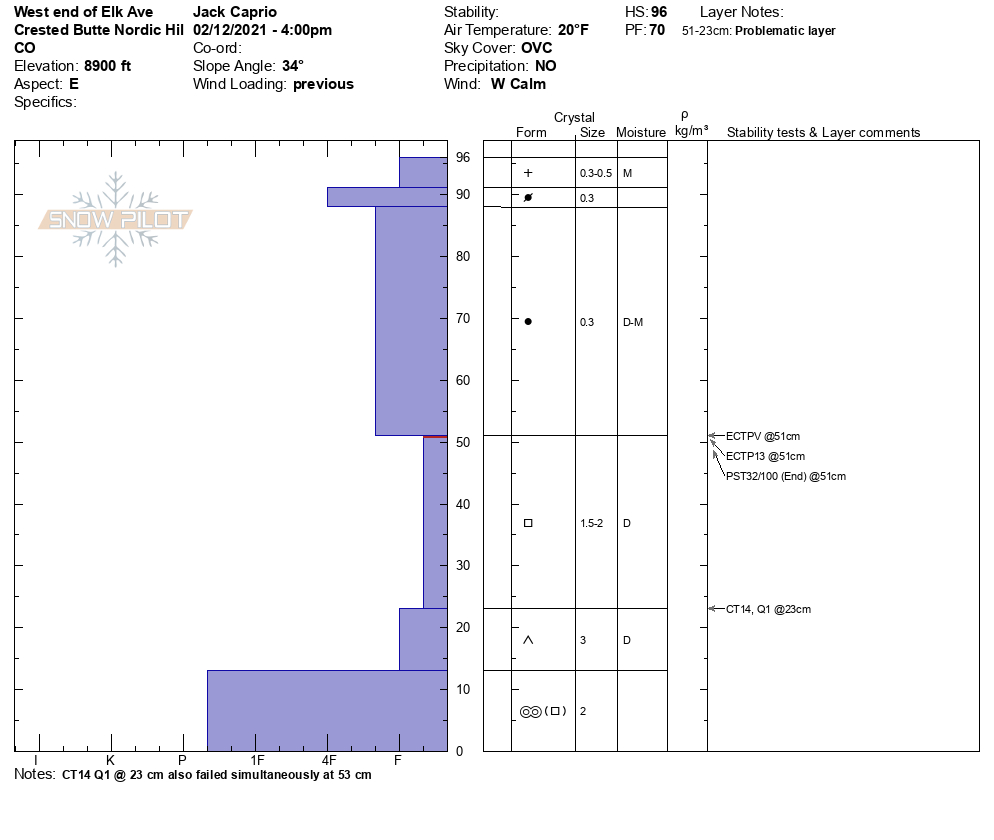
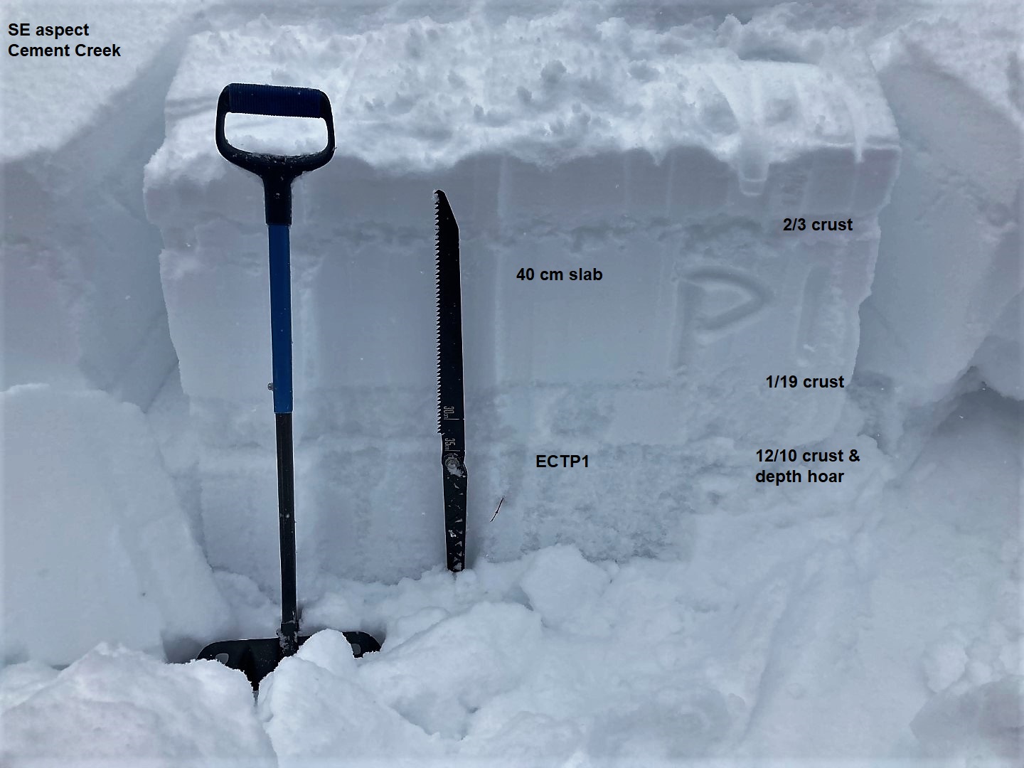
Snowpack: Looked at two snowpits to observe snowpack structure adjacent to municipal start zones. Both showed unstable structures with moderate propagating results below 45 to 70 cm slabs.
Pit 1 was dug on the west end of Elk Ave (Zone A)
Pit 2 was dug on the west end of Red Lady Ave (Zone C)
AVALANCHES, AVALANCHES, AVALANCHES! Our snowpack is getting deep and avalanches are becoming large! This week our zone has seen the most impressive avalanche cycle of the season. Check out the weekly snowpack summary to learn all about it.
Date of Observation: 02/12/2021 Name: Zach Kinler Zone: Northwest Mountains Location: Anthracites Aspect: North, North East Elevation: 10,000′-11,400′
Avalanches: No new avalanches observed, no vis of the surrounding terrain.
Weather: Cloudy, dumping snow for most of the tour, S5 average. Winds were calm to light in sheltered terrain increasing early afternoon with moderate gusts near tree line. Temps felt perfect for making snow.
Snowpack: 5″ on the skin track in the morning around 10:00 and 6″ when we returned at 14:30. 11″ HST and still going!. Small sluffs on the first couple runs turned into more storm slab type instabilities(upper 6″ of new snow) by the last run as increasing winds and snow density gave some “slabby-ness” to the newest snow. Managed the deeper weak layers by avoiding drifted slopes and the larger, un-supportive slopes and convexities.
Avalanches: A few small sluffs out of steep terrain, otherwise mostly poor visibility.
Weather: Near and above treeline were just nasty of course. Lots of snow transport and westerly winds strong enough to make you stumble. Measured about 7″ of new snow early afternoon at 10,500ft.
Snowpack: Other than small test slopes, I didn’t travel in avalanche terrain. Traveled through all the elevation bands, but didn’t spend much time up high due to the wind and weather of course. Below treeline, I got on a number of steep test slopes without results. I think the new snow in those areas wasn’t doing much for a storm slab avalanche problem, and the persistent weak layers were simply too deep in the snowpack, resulting in supported slopes that couldn’t displace if there was a collapse. Got close to other bigger steep slopes, also without anything notable. Many of those bigger slopes had also previously avalanched with crown lines still visible.
Date of Observation: 02/12/2021 Name: Irwin Guides
Zone: Northwest Mountains Location: Irwin Tenure
Avalanches: Near and ATL new Storm/Wind Slab trended Reactive to Touchy with increasing fracture length through the day, approaching D2 by the late PM. Weather: HST: 8″/.65″ with mod/heavy transporting SW-WSW wind. Snowpack: New snow is a bit upside down with 5″ of 10% on top of 3″ of 5%.
Zone: Southeast Mountains Location: Upper Cement Aspect: East, South East Elevation: BTL :9700 – 10900′
Avalanches: From 75 feet away, we remotely triggered a persistent slab that failed on depth hoar near the ground, about 2.5′ thick. The avalanche was small in size (D1) because it was on a small terrain feature. See photo. Weather: Calm winds where we traveled, audible evidence of stronger winds aloft. Very light snowfall with a few, shortlived moderate pulses. About 2″ storm total. Snowpack: Traveled to the shallowest part of our forecast area and found the depth hoar layer about 50 to 80 cm down, (12/10 layer) is very sensitive to human triggering. We experienced large, rumbling collapses and shooting cracks on almost every slope we crossed (SE and E aspects). Shooting cracks would span entire slopes and through mature aspens. Collapses would visibly shake trees several hundred feet away. Say no more, snowpack, we’ll stick to low angle terrain.
In Lower Cement Creek (down valley from Deadman’s Trailhead), snow depths are still quite shallow and there doesn’t appear to be enough volume in the start zones or tracks for natural activity to hit the road yet in most terrain
Photos:
SE aspect. Rumbling collapse triggered here.
East aspect. Rumbling collapse triggered here.
Start zones in Lower Cement appear to be lacking volume for avalanches to reach the road
One of dozens of shooting cracks
Remotely triggered persistent slab from 75′ away
Shooting cracks spanning entire slopes were common.
Shooting cracks spanning entire slopes were common.
Weather: There was no snow from sunrise yesterday until around 4 a.m. this morning when it started moderately. New snow so far of 3½” nd water content 0.24″ as the snowpack reaches 45″. Currently obscured cloud cover with moderate snow and no wind. Mild weather holds with the high 33F, low 18F and current 21F. I did hear a slide run off of Gothic but that straight face runs regularly and is not really much of an indicator. Unless you are right under it. Which I discourage. Therefore there is a high hazard for fools.
Date of Observation: 02/11/2021 Name: Alex Tiberio
Zone: Southeast Mountains Location: Gothic Mountain Aspect: South East Elevation: ATL
Avalanches: Natural Avalanche around 2/11. (CBAC Note: Best estimate from these photos is that a wind-loaded slab released near ridgelines and further stepped down into a persistent slab avalanche below the cliffs. This avalanche appears to be large to very large in size.)
Date of Observation: 02/11/2021 Name: Zach Kinler Zone: Northwest Mountains Location: Anthracites Aspect: North, North East, East Elevation: 10,000′-11,400′
Avalanches: One small Wind Slab in Red Lady Bowl, east aspect off the lookers left ridge.
Weather: Mostly cloudy, cool west breeze at ridgetop. Minimal snow transport near tree line but winds were moving snow in alpine terrain along the Ruby Range and Scarps Ridge.
Snowpack: Nice to have to use a probe to find the bottom of the snowpack instead of a ski pole or my hand! The 2/3 interface was 70 cm deep and easy to identify by the graupel layer however stability tests revealed small facets a few centimeters below the graupel. There were 2 Surface Hoar layers around the 1/19 interface with a few centimeters of 1F snow in between. This “sandwich” was failing as one in tests. This interface was buried 110 cm deep. Both interfaces popped in short column tests but produced no propagating results in ECTs. We observed no cracking or collapsing. Warm temps and a deeper snowpack have allowed these weak layers to adjust, for now. They will be tested this weekend with another strong storm moving in.
Photos:
Small Wind Slab, East ATL
Surface Hoar up to 10 mm was found around the 1/19 interface.
Avalanches: That old crown in runaway was 4+ easily. That thing was seriously impressive and a huge eye opener. (CBAC Note: That avalanche ran in the evening of the 5th or morning of the 6th, and made it from the top of Schuylkill Ridge to valley bottom.)
Snowpack: Lots of new snow on schuylkill. 12-15” easily. Breaking new trail entire way up didn’t feel any signs of instability but super efficient wind loading all day led to sluffs I believe
Two separate soft slabs in yogis. This one ran about halfway to the bench, the one on skiers left side of yogis ran all the way to bench. Didn’t get a photo
This was new today. Appears to started out as a soft slab off the ridge and then stepped down mid slope. Debris all the way to the valley floor .