Free Lesson on Carbon

CB Avalanche Center2020-21 Observations

Date of Observation: 03/17/2021

Zone: Southeast Mountains
Location: Carbon Peak North Bowl
Aspect: North
Elevation: 11,200

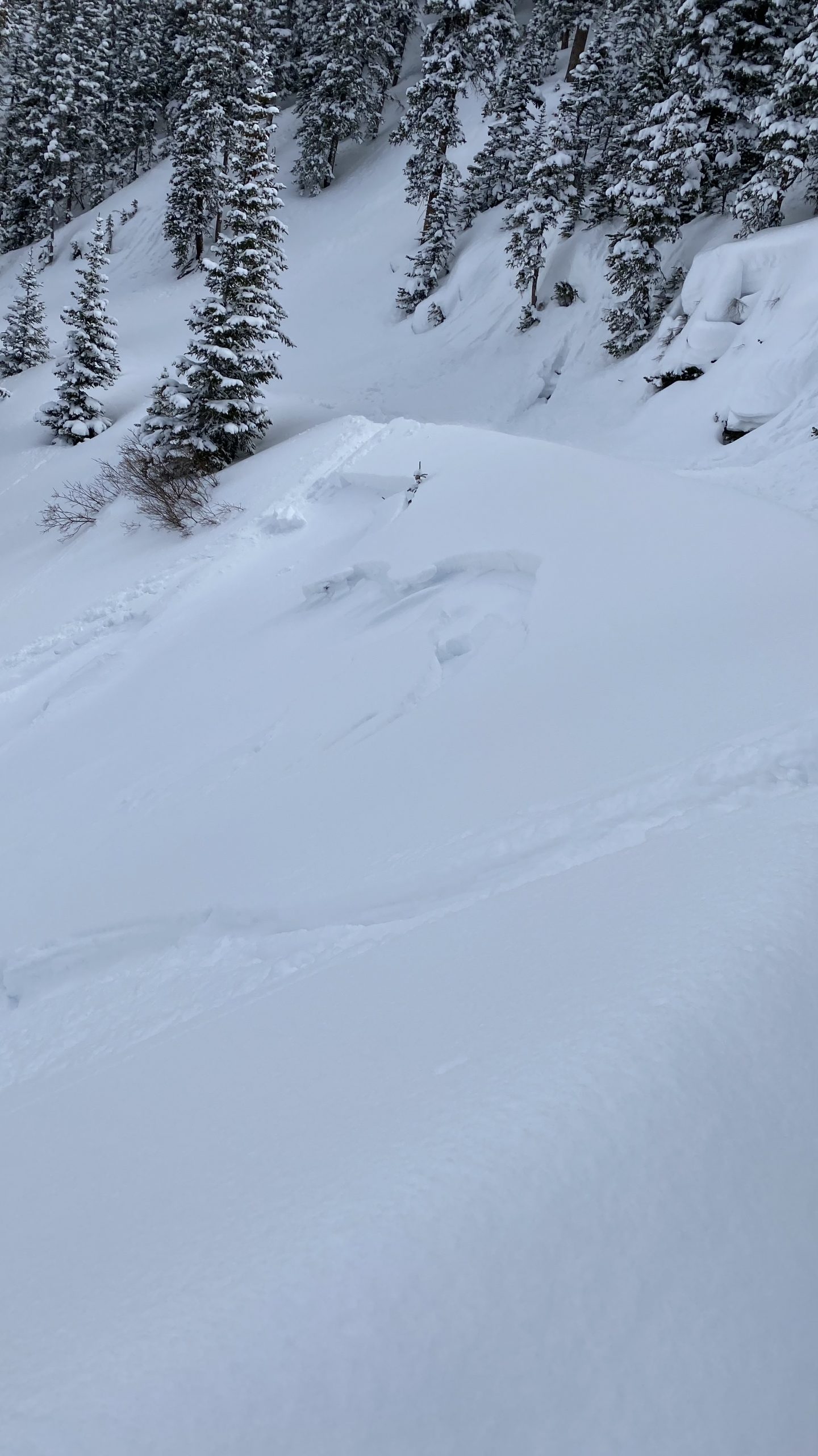
Avalanches: While making initial turns into the N Bowl on Carbon Peak, I triggered large shooting cracks that propagated 15+ meters on either side of me. After the slope fractured, the slab did not slide on a mid 30-degree slope. I was able to climb out of the start zone and we descended through low angled terrain.
Weather:
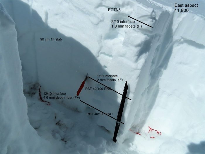
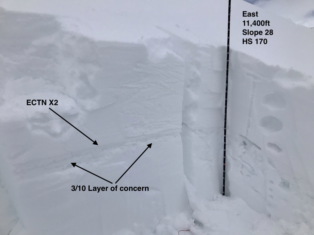
Snowpack: Throughout the day we had skied NE and SW facing terrain on Axtell without notable signs of instability. On a N aspect of Carbon Peak @ 11,200 feet, we did not find an obvious crust layer at the 3/10 interface. Snowpack tests resulted in an ECTN 26, and a CTH 25 RP, both failing in the upper snowpack. Based on the characteristics of the fracture (it appeared very deep) and the lack of instability in the upper snowpack, it seems like I may have found a trigger for one of the deeper layers in our snowpack. In retrospect, our slope of choice was perhaps a predictable location for impacting deeper weak layers.


Photos:

The edge of the donut hole

CBAC2020-21 Observations

Date of Observation: 03/17/2021
Name: Zach Guy

Zone: Northwest Mountains
Location: Upper Slate
Aspect: East, South
Elevation: BTL

Avalanches: A handful of small loose avalanches entraining the top few inches of moist snow ran this morning on southerly and easterly aspects before clouds filled in.
Ski triggered a thin wind slab on a south-facing test slope where northerly winds were drifting snow.
Weather: Clear this morning, clouds increased by midday with a few light snow showers. Light to moderate downvalley (northerly) winds at low elevations.
Snowpack: Quick tour BTL sampling storm snow totals to check on how large wet loose activity will be the next few days. In Poverty Gulch, there’s about 6″ to 12″ of settled storm snow, depending on wind effect. At Pittsburg and further down valley, only 2″ or less. The snow surface was moist from solar and greenhouse warming.
Quick pit on an east/northeast aspect BTL in Poverty Gulch produced unreactive pit results on the March weak layers, about a foot deep. The facets here have a bit of vertical separation from the crust, making for a less-distinct interface than what we’ve observed at other locations.


Photos:

Skier triggered slab

CB Avalanche Center2020-21 Observations

Date of Observation: 03/17/2021
Name: Erin Sanborn

Zone: Southeast Mountains
Location: ENE aspect of Wolverine Basin
Aspect: North East
Elevation: 11,400

Avalanches: Skier triggered shallow soft slab (crown approx 6″) around 11:45 AM. Relatively wide crown (see photo – not sure on scale, circle on photo is where the skier dropped in); slough stopped approx 2/3 down the aspect. Skier able to ski out of the moving snow. It appeared that another slab on skier’s right was also triggered; possible remote trigger further skier’s left under a cornice (the party of 4 was not certain if the latter slide noted was there at start of ski – unable to determine from above cornice, but worth noting). Second photo shows smaller slab that was likely triggered remotely. This was the first skier to descend, making some of the observations from above difficult to determine.
Weather: Mid-20s; partly sunny; morning wind when skiing up Red Lady, but not wind at the time of the event.
Snowpack: One very small roller noted on the aspect that was skied. We noticed what appeared to be a natural wet slide was noted in Red Well basin on the east facing aspect earlier in the morning.

Photos:

The persistent slab evolution

CBACBackcountry Notes

An update on our persistent slab problems.  March 16, 2021. By Zach Guy, Lead Forecaster

You will notice in our forecasts a change in travel advice, size, and likelihood of the persistent slab problem –  a problem that has been on the bulletin all winter.  We have several persistent weak layers in the snowpack, and we are restructuring how to present them as avalanche problems as we move forward this week. As much as we’d like our problems to fit into a nice, clean box, often the snowpack blends problems and blurs the lines.  Our goal is always to make clear and simple travel advice using avalanche problems as a foundation.  For that reason, here are the changes you can expect as our snowpack evolves.

  • We have a new persistent slab problem that is just starting to evolve, the result of weak layers that formed in late February and early March.  It has been the culprit in a handful of triggered slides in the past week, including a few remote triggers (example A, example B).  Up until now, we’ve been calling it a storm slab or wind slab in our problem list.  The problem isn’t well developed yet because we simply haven’t had much snow on these layers yet.  You can find it now in areas where the winds have loaded snow, or in areas that got more snow out of this last storm.  The weak layers of concern were most recently buried on March 10th, so we’re calling it the 3/10 weak layer.  It is actually a stack of weak layers that formed throughout the dry spell that started in mid-February, that was interrupted by a few small snowfall events and warmups in early March.  Thus, it presents itself as either a crust/facet/crust layer or near-surface facets, or some combination of the two.  It is especially weak where it formed on the bed surfaces of avalanches that ran in mid-February (and there were a lot of avalanches in mid-February).  That’s because the snowpack on those slopes is shallower and more prone to advanced faceting.  So far, we’ve only found it to be a concern on northwest, north, northeast, and east aspects.  That’s because the facets got cooked on hotter slopes and/or the crusts are thicker and stronger on those more southerly aspects.   The photo below demonstrates what that problem looks like near Kebler Pass right now.

  • We are phasing our old persistent slab problem off of the problem list – and by that, we mean the large-grained weak layers near the ground that formed early in the season (The 12/10 layer and 1/19 layer).  Apart from wet slab issues, which are a different beast, those layers have been dormant since late February. This last storm was a modest test on deep layers and we didn’t see evidence of them becoming an issue again.   This problem has been a blend of a persistent slab or deep persistent slab since February, depending on your location in the forecast area and what aspect you are on.  We kept calling it a persistent slab across our forecast zone for simplicity’s sake.  If we reintroduce this problem later in the spring due to a major storm, we will likely be listing it as a deep slab problem, to prevent overlapping and confusing travel advice for the newer generation of persistent slabs.   We are phasing it out as one of the primary problems because triggering one of these deeper layers has become very unlikely under our current weather pattern.  That could certainly change with future storms, and it is impossible for us to completely rule out an oddball avalanche that breaks on deep layers.  The most probable scenario for a deep failure would be a large cornice fall.  Of course, basal weak layers could also  reemerge as a problem during spring melt, in which case we’ll present them as a wet slab problem.  The image below shows an example of the 12/10 and 1/19 layers on Mt Whetstone last week.


Upper Cement and Upper Taylor Recreational Snowmobilin’

CBAC2020-21 Observations

Date of Observation: 03/16/2021
Name: Eric Murrow


Zone: Southeast Mountains
Location: Cement Creek to Upper Taylor
Aspect:
Elevation: 9,000′ – 12,100′


Avalanches: Observed two small slab avalanches on northeast (Hunter Hill) and east (Star Pass) alpine features.
Weather: Mostly cloudy skies with a few periods of sunshine. Winds were light even above treeline in typically windy places, no transport observed. New snow accumulation up to 1.5″ overnight with a few short bursts of S1 during the day.
Snowpack: Recreational snowmobile day so made few snowpack obs, only digging was to free my snowmobile. I did measure new snow accumulations since Saturday at the head of Cement Creek at 11,400′ and found 11″ with 1.1″SWE. Snow volumes tapered very quickly as you headed down the valley with just 7 inches near Hunter Creek and only 3 inches at the Cement Creek TH. Below treeline slopes facing east through south through west developed a soft melt/freeze crust on Monday with a dusting to 1.5″ new sitting above. Northeast through southeast slopes near treeline appeared well drifted from the weekend; above treeline loading was a bit more variable depending on the local terrain shape.


Photos:

Kebler Pass

CBAC2020-21 Observations

Date of Observation: 03/16/2021
Name: Evan Ross

Zone: Northwest Mountains
Location: Kebler Pass
Aspect: North East, East, South East, South
Elevation: 9,000-11,500ft

Avalanches: A few small sluffs on the south side of Ruby.

Weather: Mostly cloudy with just enough snow and heat to thicken the new snow. About 3″ of snow had accumulated this since early AM. Calm Wind.

Snowpack: Primarily traveled on easterly slopes between 10,500ft and 11,500ft. In these areas, the 3/10 interface was down 40 to 50 cm’s on average, below mostly F hard snow and a couple of other thin crusts. That interface has been well documented and consisted of two crusts with weak snow between. The thin layer of snow between those crusts is notably soft, 1 mm faceted grains. Those faceted grains did have some soft and slightly rounded edges to them.

Dug a test pit on a 28-degree east aspect at 11,400ft. ECT tests were a bit inconclusive. 2 hard ECT N’s, with an additional loading step in one test that finished the propagation through the weak snow between the crusts. Of other note, the only way to isolate a column of snow without cracking and breaking sections of the crust was with a sharp cord on all sides of the column. A shovel blade was to coarse and broke notable sections of the crust when used to clean snowpit walls.

Snowmobile slammed a whole lot of test slopes with no results. Traveled very near several bigger terrain features with no remote triggered results. Despite the lack of red flags or signs of instability, the snowpack structure still appeared concerning and will take time to earn my trust.

Small Skier Triggered Slide

CB Avalanche Center2020-21 Observations

Date of Observation: 03/15/2021
Name: Jacob Dalbey

Zone: Northwest Mountains
Location: Redwell Basin
Aspect: North, North East, North West
Elevation: 11,100’

Avalanches: Small (D1) skier triggered storm slab on NW/W aspect btl. Crown approx 10-12”. Failed on a crust as two ski tracks on more northerly aspect directly adjacent to slide produced no activity.

Weather: Cold. Snowy in the morning with patches of blue sky popping through. Mostly clear midday and warm in the sun. Snow was rapidly settling when touched by the sun. Overcast and snowy mid afternoon on exit

Photos:

Kebler BTL no signs instability

CB Avalanche Center2020-21 Observations

Date of Observation: 03/15/2021
Name: jeff banks

Zone: Northwest Mountains
Location: Kebler
Aspect: North
Elevation: up to 10,600

Avalanches: none
Weather: cool
Snowpack: no signs of instability on small test slopes up to 40* N facing sheltered in forest.
~12″ of settled pow, well bonded to old snow.
HS 135cm-155cm

Gothic 7am Weather Update

CBAC2020-21 Observations

Date of Observation: 03/16/2021
Name: billy barr

Zone: Southeast Mountains
Weather: Probably the most snow we received during this whole storm was from 5 to before 7 a.m. this morning with 2″ new, but then only 0.11″ of water with it. The 24 hour total was 3″ new with 0.15″ of water and snow pack is at 44½” deep. Mild with the high 36F, low 11 and current 18. Currently cloudy with light snow and no wind.

I don’t mind cut-off lows

CBAC2020-21 Observations

Date of Observation: 03/15/2021
Name: Zach Kinler
Zone: Northwest Mountains
Location: Kebler Pass area
Aspect: North, North East
Elevation: 9,000′-11,200′

Avalanches: No new avalanches observed skies were overcast with limited vis into the surrounding terrain.

Weather: OVC, sporadic light snow showers throughout the day amounted to little additional accumulation. Winds were calm below tree line and very light near tree line. Temps remained below freezing.

Snowpack: Measured 8″ of new snow overnight which was very low density, around 3%-4%. 2 day HST in this zone is now 22″/~1.25″ SWE. Hand shear tests were breaking above the new/old interface at a density change. No signs of instability were noted while skiing slopes up to 38 degrees in this terrain. Minor cracking was observed in the deepest drifts near tree line. No results ski cutting slopes that produced small slab avalanches yesterday in this terrain as storm and wind slab instabilities are settling out.