3/25 Avalanche obs

CB Avalanche Center2019-20 Observations

Location: Crested Butte Area
Date of Observation: 03/25/2020
Name: Zach Kinler
Subject: 3/25 Avalanche obs
Aspect: North, North East
Avalanches:

Axtel NE 11,800′ D1.5 Wind Slab
Whetstone NNE 11,800′ D2 Persistent Slab

Weather: Mostly Cloudy skies, Light westerly winds below tree line, temps remained cool in the 30s.

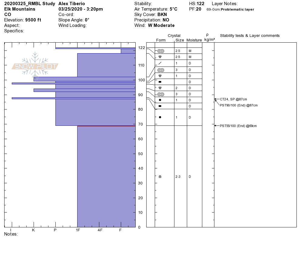
Snowpack: Snowpack at Elkton Study Plot was deepest of the year at 185cm. 3/18 interface is a thick 6 cm crust with 1mm rounding facets on top and is down 35 cm with 4F to 1F slab on top. CT 16 SC, ECTN28(crossed column on taps 29,30). All other interfaces have seen free water in this location.

Wind Slab NE 11,800′ Axtel

Persistent Slab 11,800′ NNE Whetstone

Crown observed in California Bowl on Snodgrass

CB Avalanche Center2019-20 Observations

Location: Crested Butte Area
Date of Observation: 03/24/2020
Name: Nick
Subject: Crown observed in California Bowl on Snodgrass
Aspect: North East
Elevation: 10,700

Avalanches: Observed a couple day old crown that showed signs of wind effect, approx 18in deep and spanning about 40 feet. Ski cutting hangfire produced a small slab pocket about 10ft x 10ft with an 18in crown. Looked to be on the old snow- new snow interface.

Weather: Sunny, partly cloudy

Photos:

Afternoon Look Around Kebler Pass Area

CB Avalanche Center2019-20 Observations

Location: Kebler Pass Area
Date of Observation: 03/24/2020
Name: Evan Ross
Subject: Afternoon Look Around Kebler Pass Area

This is a story book observation. See photos and descriptions.

Mountain Weather for 11,000ft. Wednesday 3/25

CB Avalanche CenterWeather

Date: 03/25/2020

A large trough over the Pacific NW will slowly migrate southeast today bringing a strong 170 kt jet stream directly over Colorado. This will leave our area under WSW flow which will transition to SW tonight and tomorrow as the trough digs south. That strong jet stream will drive winds to the surface again today with some enhancement from afternoon heating. Expect passing clouds, warm temperatures, and gusty winds through the day and into this evening with a slight chance of a passing snow shower.

Similar conditions look to develop tomorrow as the trough pulls closer to Colorado. SW winds will be strong and gusty with passing clouds and similar highs as today. The main trough move through Friday with increasing chances of snow and cooler temperatures.

  • Today

    High Temperature: 35 to 40
    Winds/Direction: 15 to 25/WSW G40
    Sky Cover: Partly Cloudy
    Irwin Snow: 0 to 1″
    Elkton Snow: 0 to 1″
    Friend’s Hut Snow: 0 to 1″

  • Tonight

    Low Temperature: 23 to 27
    Winds/Direction: 15 to 25/SW
    Sky Cover: Partly Cloudy
    Irwin Snow: 0
    Elkton Snow: 0
    Friend’s Hut Snow: 0

  • Tomorrow

    High Temperature: 35 to 40
    Winds/Direction: 15 to 25/SW G35
    Sky Cover: Partly Cloudy
    Irwin Snow: 0 to 1″
    Elkton Snow: 0 to 1″
    Friend’s Hut Snow: 0 to 1″

M Face Avalanche – Whetstone

CB Avalanche Center2019-20 Observations

Location: Crested Butte Area
Date of Observation: 03/24/2020
Name: Whitney, Syd, and Cheese
Subject: M Face Avalanche – Whetstone
Aspect: North East

Avalanches: Large avalanche on M face of Whetstone! Up close. Skied the Summit bowl and it was awesome! Small signs of instability skinning up the ridge between Summit Bowl and M face, some cracking and one collapse. Beautiful Day!

Weather: Mostly sunny, intermittent clouds with L winds.

South side of Baldy

CB Avalanche Center2019-20 Observations

Location: Paradise Divide Area
Date of Observation: 03/24/2020
Name: Zach Kinler
Aspect: East, South East, South, South West, West
Elevation: 10,500′-12,000′
Avalanches:

No new avalanches observed

Weather: Pleasant day, Partly Cloudy skies, temperatures warming to near freezing. Calm to light breezes in sheltered areas with Light to moderate westerly wind near tree line.

Snowpack: 5″ new snow around 11K. Up to 11,500′ this snow became moist on the southern half of the compass. Above 11,500′ surfaces were mostly dry with increasing westerly winds transporting snow onto easterly aspects. Small drifted terrain features had deposits up to a foot deep with cracking from skis traveling 10-20 feet. Last week’s crust was around 60 cm below the surface. Avoided larger drifted features in this terrain. Once below 11,500′ warming surfaces limited available snow for transport with similar slopes producing no instabilities. Winds increased after 16:00 with moving snow visible on the highest peaks.

East aspect 11,800′

Moderate westerly winds were transporting snow onto leeward aspects

Winds increased by late in the afternoon moving available recent snow

Gothic 7am Weather Update

CB Avalanche Center2019-20 Observations

Location: Paradise Divide Area
Date of Observation: 03/24/2020
Name: billy barr
Subject: Gothic 7am Weather Update

Weather: cloudy and mild with light snow, mostly in the few hours after dark with stronger wind into the night but then letting up by 9 p.m. Total 24 hour snow was 4½” with 0.35″ of water. Snow pack is at 54½” and holding somewhat steady. Currently overcast and calm with the temp. 22F, the low of the day.

Mountain Weather for 11,000ft. Tuesday 3/24

CB Avalanche CenterWeather

Date: 03/24/2020

Well, the storm came, now it is going, and what happened in between? Not a lot. At 5am this morning we are currently looking at 3.8 centimeters of new snow!! That sounds a lot better than 1.5 inches. The upper atmosphere has dried out, but we still have low-level residual moisture hanging out. So we should continue seeing some light snow this morning before the sky becomes more partly cloudy later today. The cloud forecast is a bit uncertain with the low-level moisture is going to play out.

Looking at the rest of the week. we stay on the dry side of the line until Thursday, but again we will see some flakes here and there as it looks like we’ll continue to have some low-level moisture about. The big change coming up will be the wind. A strong 150kt jet moves overhead tonight as we look ahead to a windy midweek. The alpine is going to get blown, and we’ll also see some strong winds mixing down to lower elevations.

Another low-pressure system will be moving across the desert southwest later this week and line up as our next storm. Snow will probably begin with that storm late on Thursday.

  • Today

    High Temperature: 33 to 37
    Winds/Direction: 10 to 20/SW
    Sky Cover: Partly Cloudy
    Irwin Snow: 0 to 1
    Elkton Snow: 0 to 1
    Friend’s Hut Snow: 0 to 1

  • Tonight

    Low Temperature: 22 to 26
    Winds/Direction: 12 to 22 G45, WSW
    Sky Cover: Partly Cloudy
    Irwin Snow: 0 to 1
    Elkton Snow: 0 to 1
    Friend’s Hut Snow: 0 to 1

  • Tomorrow

    High Temperature: 33 to 37
    Winds/Direction: 10 to 20 G40, WSW
    Sky Cover: Partly Cloudy
    Irwin Snow: 0 to 1
    Elkton Snow: 0 to 1
    Friend’s Hut Snow: 0 to 1

Mt Emmons Avalanche Visit

CB Avalanche Center2019-20 Observations

Location: Crested Butte Area
Date of Observation: 03/23/2020
Name: Evan Ross, Zach Kinler
Subject: Mt Emmons Avalanche Visit
Aspect: North East, East
Elevation: 11,800ft

Avalanches: This avalanche is estimated to have released on the morning of 3/22, during a period of intense wind-loading and a pulse of high precipitation rates. The subtle aspect changes along the crown varied from NE to E and the snowpack structure was notably different between those changes. The avalanche was small for the terrain (R1) and large in destructive size (D2), therefore capable of burying a person. We spend our time on the deepest section of crown. The crown in that area average 60cm and was up to 125cm tall. The avalanche failed on-top of two separate crusts. Those crusts were each 2cm thick with the upper being Pencil hard and the lower 1F hard. Where there was the most wind-loading the avalanche failed on the deeper crust, lower on the ridge where there was less wind-loading the avalanche failed on the upper crust. Both of those crusts had 1.5mm facets on top and 1 mm facets below. Those facets were not particularly weak and didn’t produce results in ECT or PST tests from two separate locations along the crown. On the more NE tilted portions of the crown, the crusts faded away, but a thin layer of small rounding facets could still be found. The slope angle near the crown averaged in the upper 30’s and rolled over steeper lower on the slope.

There were some cracks in lower angled sections of the slope above the crown. Though of interest, there were no shooting cracks past the flanks of the avalanche or lower in the bowl where the avalanche debris passed through and came to a rest. The flanks of the avalanche noticeably decreased lower on the slope and below the previous wind-loading.