Angel ridge and Schuylkill Peak Avalanches

CB Avalanche Center2020-21 Observations

Date of Observation: 02/07/2021


Zone: Northwest Mountains
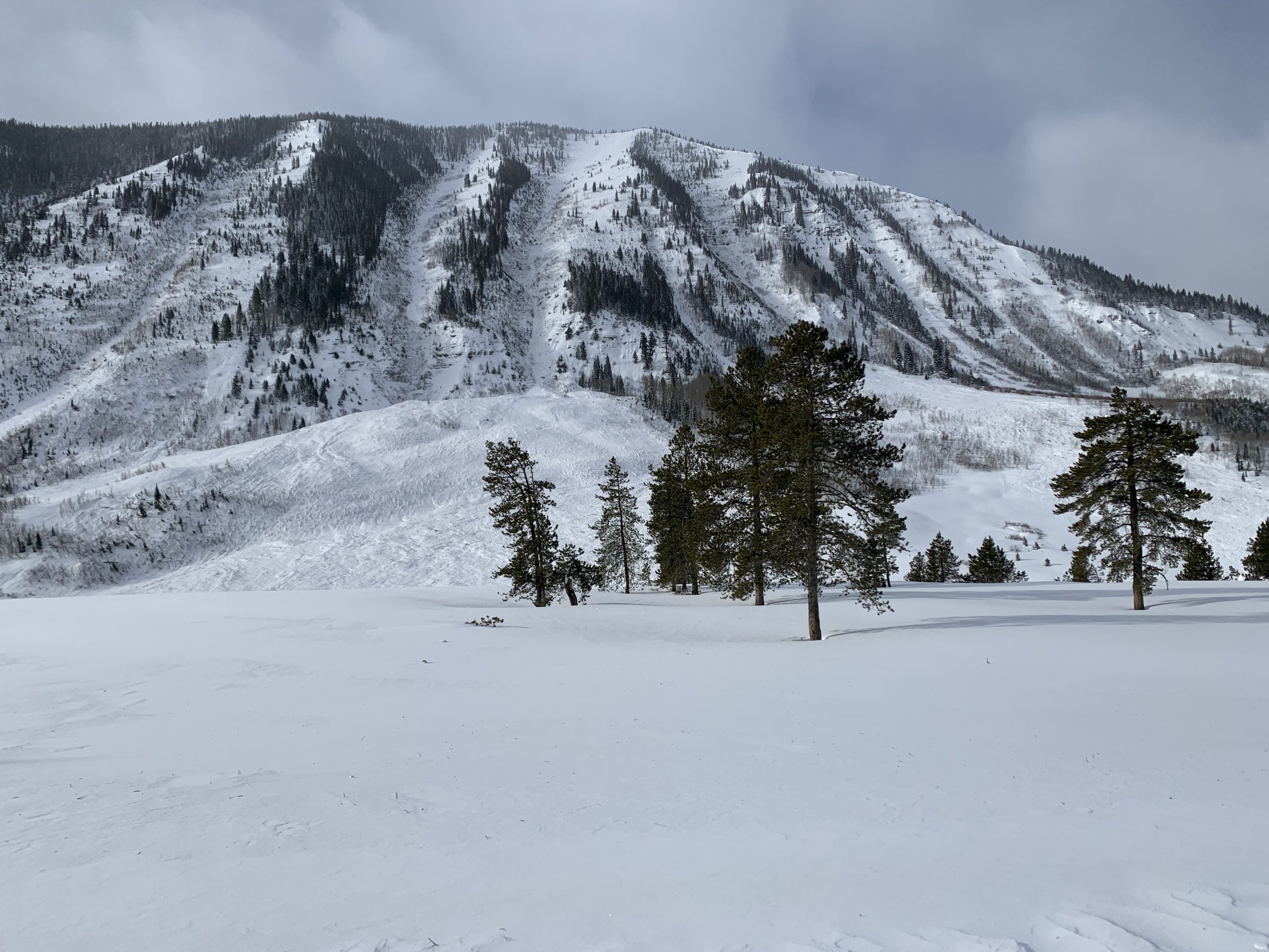
Location: Seen from Camo trees.
Aspect: North, North East
Elevation: Atl. 11.5ish


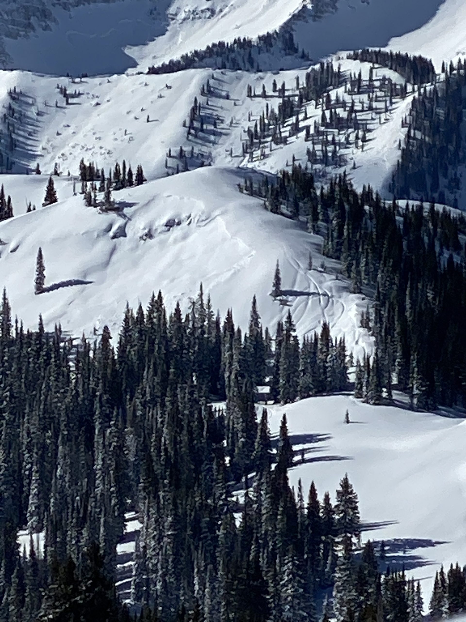
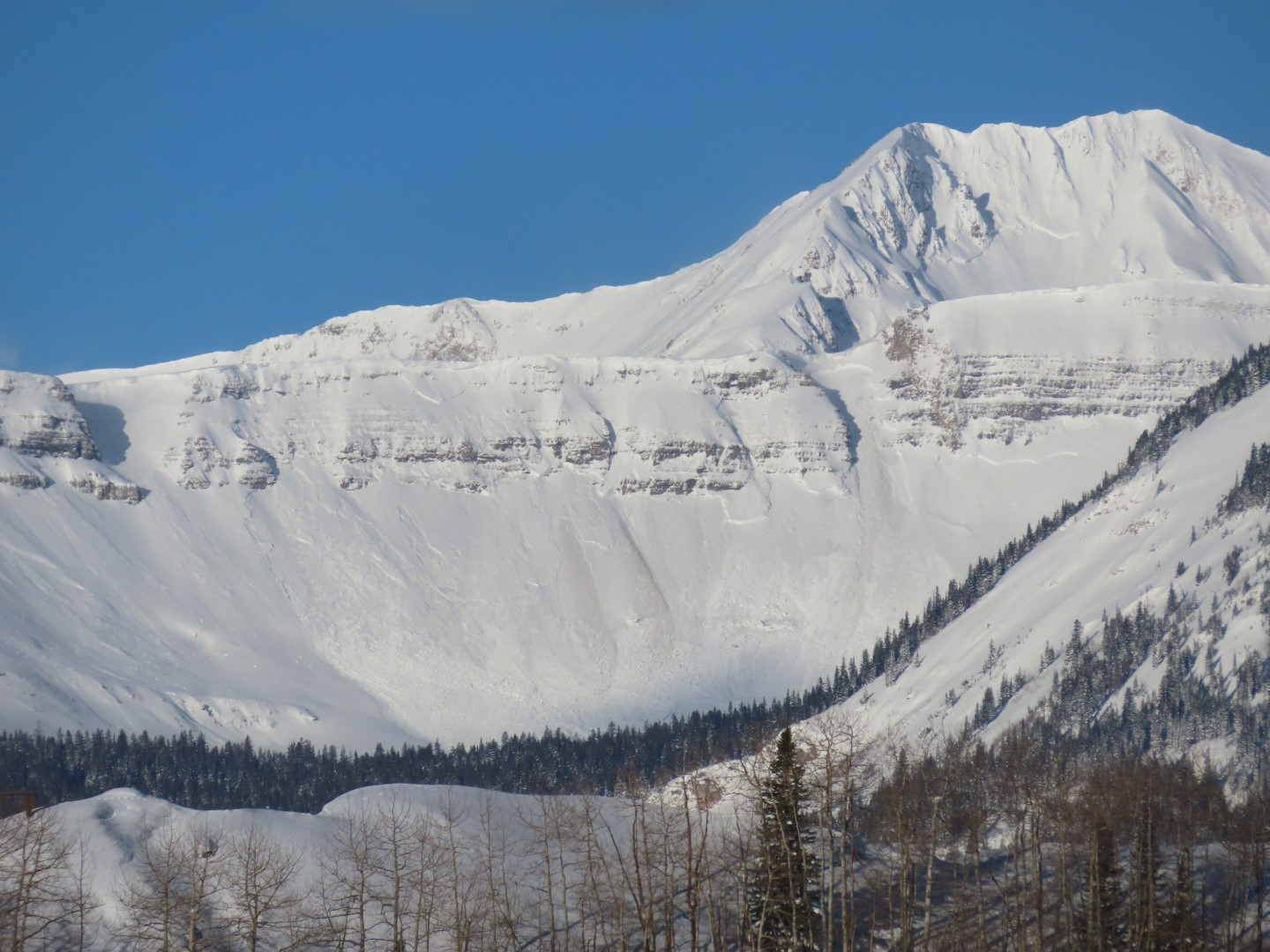
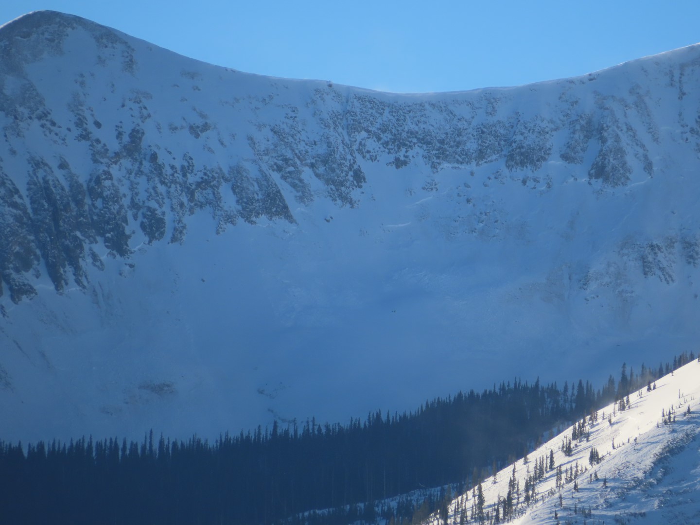
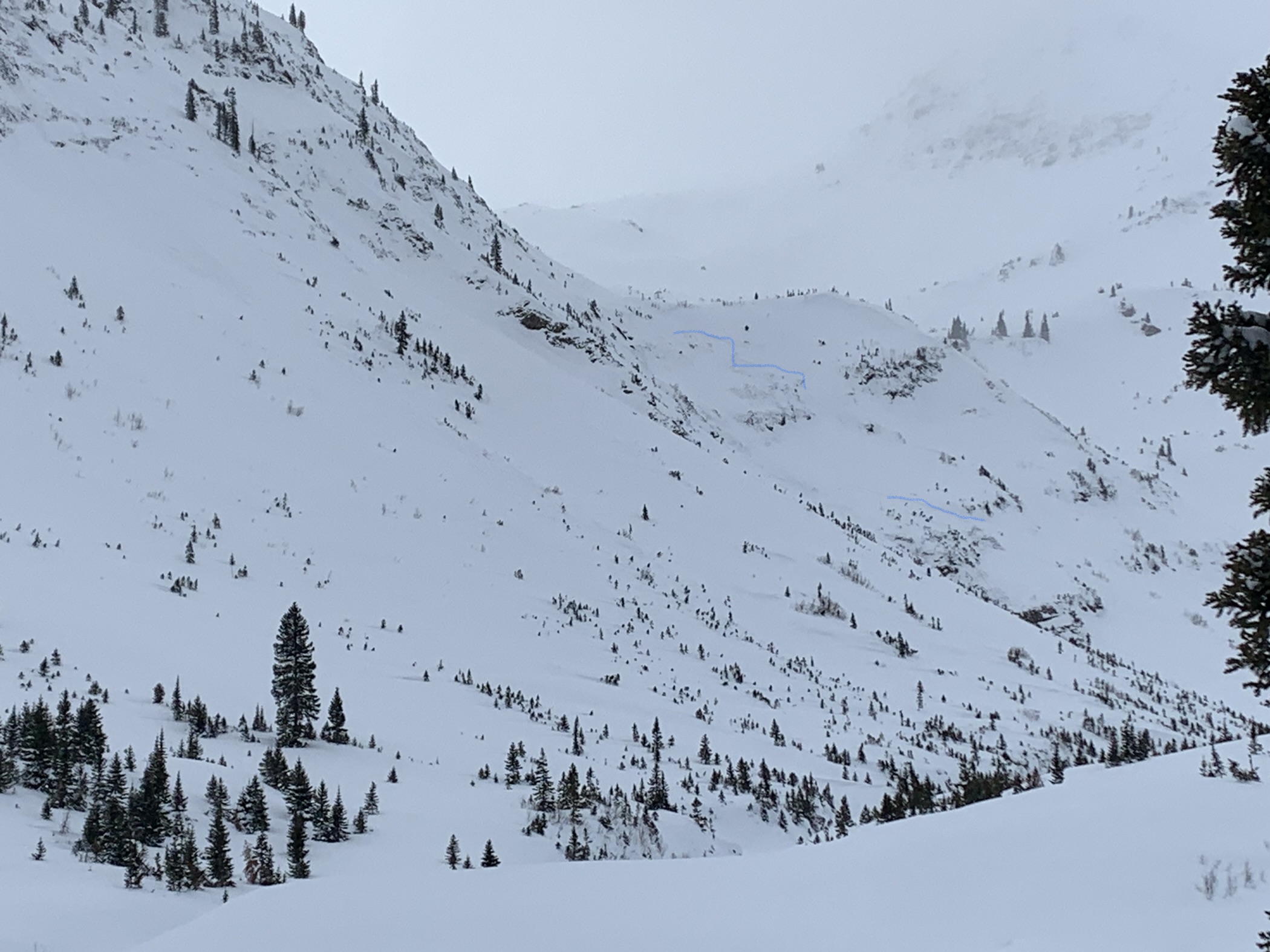
Avalanches: Everywhere on East slopes, with many north and some southeast with start zones generally ATL and running long seemingly due to wind loading being the straw. Most appeared to go to ground in at least some parts of start path and step down. Pictured: D2.5+ schuylkill peak. D2 on angel ridge. Ran long. Almost to creek on both and thru lots of terrain often too flat to ski. Hard to tell height of crown but visible ground underneath crown.
Weather: Warm At valley bottom with cold wind As you got into Baxter. Sunny, didn’t see evidence of too much warming on southern slopes at that elevation although a crust on south wouldn’t surprise. Windy ridge tops with visible and constant transport on east facing slopes.
Snowpack: Finally supporting sled weight. Lower angle north trees had wind texture and somewhat thicker snow, but overall fun and fast powder. Didn’t dig today as the evidence and warning signs were apparent, last storm snow had been significant and wind loading especially on East faces was obvious from the avalanche activity.


Photos:

Mt Emmons Avy 1

CB Avalanche Center2020-21 Observations

Date of Observation: 02/07/2021
Name: Evan Ross

Zone: Southeast Mountains
Location: Mt Emmons
Aspect: South East, South
Elevation: 9,200-11,700

Weather: Partly cloudy sky, warm temps, winds increasing in the afternoon. At times snow was transporting off the peaks and NTL/ATL ridgelines, though not consistently and fetches were running lower.

Snowpack: 2/7. No obvious signs to instability observed. The upper snowpack was becoming thick with warm temps and the sun. In the afternoon the wind started to buff the snow surface and create pockets of stiffer wind board around 11,000ft. We simply used the terrain to manage the avy problems, had some good turns and didn’t go looking for unstable conditions.

2/6. Similar tour as the following tour on 2/6. We spent a bit more time investigating the snowpack structure on a ESE aspect at 10,400ft. The slope angle at this sight was about 30 degrees. HS 140cm. The 12/10 interface was easy to feel with a ski pole and identify in the pit fall. This layer of concern consisted of F hard ~2mm NSF. Facets below the crust at the 1/19 interface were not immediately identified in the pit wall. Small column tests more clearly identified this 2nd layer of concern and produced sudden results. No obvious signs to instability were observed on this tour, until a couple occasions were someone didn’t have skis on and punched deeply into the snowpack. Several large collapses resulted.

Guess what!

CB Avalanche Center2020-21 Observations

Date of Observation: 02/07/2021
Name: Lee Pow


Zone: Southeast Mountains
Location: Elk basin area, no name ridge
Aspect: South East, South, South West
Elevation: 9000-11000


Avalanches: A few D2’s off of primarily southern aspect, solar influenced.   1 ran at ~10am, the others maybe 2 hours after.  2 shaped drainages in the lower reaches slid wall to wall, likely during our last load
Weather: Sunny and windy AF
Snowpack: Guess what? It’s all facets.
130cm hst, 3 melt freeze crusts 3cm or thinner, about 20cm apart, all facets from about 40cm down. With about 20cm of windbuff on top. Like sour cream on top of a rotten burrito.

Tried 2 ects, both failed before fully isolated ;)~

Its going to get better……right????


Lower Slate goes big

CB Avalanche Center2020-21 Observations

Date of Observation: 02/07/2021
Name: Frank Stern


Zone: Southeast Mountains
Location: Lower Slate River
Aspect: North East
Elevation: 9000-10,500′


Avalanches: Most of the Climax chutes ran down to the river. Scarp’s Ridge and Schuykill.
Weather: Sunny, 32 F, 10 mph wind
Snowpack: Was stable on flat ground


Photos:

Crowns galore: Morning avalanche obs

CB Avalanche Center2020-21 Observations

Date of Observation: 02/07/2021
Name: Zach Guy


Zone: Northwest Mountains and Southeast Mountains


Avalanches: See photos, numerous D2 to D3 slides near and above treeline. Many of these were first observed yesterday morning, I’m just adding some higher res photos. We didn’t have views of the Ruby Range yesterday so some of these are new observations, although the timing is uncertain. The slide above Axtell’s Green Lake likely ran last night (maybe initiated by cornice fall?) because I didn’t see those crowns yesterday. Will add estimated sizes and aspects later tonight.
Weather:
Snowpack:


Photos:

Carbon

CB Avalanche Center2020-21 Observations

Date of Observation: 02/06/2021
Name: Emilio Alcala


Zone: Southeast Mountains
Location: Carbon Peak North
Aspect: North
Elevation: 9,200 – 11,200


Avalanches: One large avalanche that broke during the early morning of 2/6 on a steep, cross-loaded, north-facing bowl off Carbon. Seems to have broke within old snow.
Weather: Moderate west winds, partly sunny
Snowpack: New snow ranged from 12-14″. Widespread collapsing and cracking on north-facing slopes off of Carbon. Slab is soft lower on the face and is where most of the collapsing/cracking occurred. As we moved higher up the face, the slab stiffened and supported the weight of a skier. Around 11,000ft, snowpack height averaged 150cm and surface snow has stiffened due to wind.  Blowing snow was observed from ridgetops all day on to easterly facing slopes.


Photos:


Avy 1 Snodgrass (Frontside) Observation Tour

CB Avalanche Center2020-21 Observations

Date of Observation: 02/06/2021
Name: David Bumgarner


Zone: Southeast Mountains
Location: Front Side of Snodgrass
Aspect: North East, East
Elevation: 10,000


Avalanches: We saw a D1 slide on an east aspect later in the day. We had toured near it (see photos) earlier in the day, did not see it go at that time but saw the avalanche later in the day. Not sure if we remote triggered the slide or if it happened naturally later in the day. Did see the aspect getting wind loaded later in the day.
Weather: Temp: Mid 20’s
Wind: light in the area we toured (moderate gusts during our tour)
Sky: Partly cloudy
Precip: None
Snowpack: Pit:
Elevation: 10,360
Aspect: East
Slope angle: 26
HS: 106
CT M SC
ECTP Moderate (13/16/19) SC 31cm down on the 1/19 interface (see photo)

Note: I dug a pit with a course in this area 10 days earlier and was not getting propagating results. The new load has added enough load to stress this layer.
We had multiple collapses throughout our tour.


Photos:

Slide near Coneys

CB Avalanche Center2020-21 Observations

Date of Observation: 02/06/2021


Zone: Southeast Mountains
Location: Washington Gulch
Aspect: North East
Elevation:


Avalanches: Fresh slab avalanche just north of Coneys. Released from convex rollover and ran into gully
Weather: Cloudy, windy and temperature around 20 f.
Snowpack:


Photos:

Slate River Carnage

CB Avalanche Center2020-21 Observations

Date of Observation: 02/06/2021
Name: Emma Lohr


Zone: Northwest Mountains
Location: Slate River Road
Aspect: North, North East, East, South East
Elevation: 10,500


Avalanches: A multitude of very large avalanches from Climax back into Poverty Gulch. Some with start zones in the high alpine, and some running from mid-slope.
Weather: Short-lived cloud lifting provided good viewing of the full effect of last night’s winds. Snowing on and off throughout the day. Seemed to be more wind transport than accumulation.
Snowpack: Kept it low angle, with some cracking observed on more continuous slopes. Got a few collapses on an already broken skin track, as well.


Photos: