Absurduary: A look at our warm and dry start to 2015.

CB Avalanche CenterAvi Blog, Avi-Off-Season

CBAC Forecaster Zach Guy.  
February 12, 2015

In the past few weeks, I’ve seen streams emerge from high elevation basins, sunny slopes melt back to complete dirt, and a migration of locals towards the desert for mountain biking or sun bathing.  I’ve only lived in Crested Butte for four years, but this pattern seems so absurd for a high Rockies mountain town at 9,000 feet in elevation, that I dug into some historical weather to see how unusual this weather has been.

Since the New Year, we’ve been plagued by both snowfall drought and unseasonably warm temperatures.  The temperatures have been the greatest anomaly this winter.  billy barr in nearby Gothic has an exceptional record of temperatures and snowfall dating back to 1974 (www.gothicwx.org).  As of Friday, February 12th, 17 out of our 43 days this year have seen record-breaking high temperatures.  There have only been two days in February that didn’t break a temperature record, and we are currently going on 8 days in a row of record high temps. I expect the next two days will break records too.  On February 6th, the temperature hit 52 degrees F, which was a full month earlier than we’ve ever seen temps reach into the 50’s.  I think my brother in Florida is having a colder winter right now.

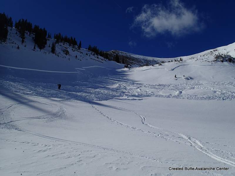
Looking towards Red Lady Bowl and some dirt slopes down lower.  Last year on this date, I dug a pit on a similar slope as that dirt slope in the foreground and found a 2 meter deep snowpack.


Snowfall droughts this time of year aren’t quite as unusual as the temperatures we’ve seen.  I looked at both Gothic snowfall and records from the town of Crested Butte, which date back to 1962.  (http://www.crestedbutte-co.gov)  In Crested Butte, where the average snowfall in January is 41.6”, we got 10.6” of snow last month.  There have only been four other January’s that saw less snowfall in the past 52 years.    February is off to a rough start as well, with only a few inches.  If it makes you feel any better, the winter of ’76-’77 only saw a total of 3” of snow from December through February in Crested Butte.  Too bad they didn’t have fat bikes back then. Gothic has fared marginally better on snowfall.  They saw 27” in January, which is 41% of average and the 8th lowest January on record.  Gothic picked up 6” in February, which is on pace to come up at 21% of the 70” average for February. Thanks to a healthy November and December, Schofield Pass SNOTEL is sitting at 67% of mean (3rd lowest snowpack in its 30 year record), and the Mt. Crested Butte SNOTEL is at 80% of its mean.

As someone who loves the winter, I can’t help but feel gloomy over the past couple months.  However, models keep hinting at a pattern change coming later this month or in March, for the warm and dry high pressure ridge to shift west and put us back into the storm track.  We’ll see…  And also worth noting, the horrible snow year of ’76 to ’77, which was the lowest on record at 61” in Crested Butte, was followed the next winter by the highest snowfall on record, at 381”.  I’ll stick around next winter to see what happens!

Looking towards Mt. Crested Butte.  Looks more like late April than early February.

Mountain Weather for Friday, February 13th, 2015

CB Avalanche CenterWeather

Date: 02/13/2015

Today, look for mostly clear skies, light winds, and temperatures pushing 40 degrees.

The Baja Low has re-established itself over, well, Baja once again…and that damn high pressure has strengthen over the western half of the United States…again. But…there is a war being waged in the Gulf of Alaska, as a firehose of Pacific moisture is bombarding the dome of high pressure and something has to give eventually. Early next week..the good guys finally prevail, and moisture begins to sneak its way into the Great Basin, along with colder temperatures. This may be the beginning of a larger scale pattern change…but we’ll humbly oblige with a few inches of snow to get things going around Tuesday.

Mountain Weather February 12, 2015

CB Avalanche CenterWeather

Date: 02/12/2015

About this date last year my back blew out from shoveling out from our 10-day huge storm. This year, my back is only slightly irritated from the sunburns from lounging on my deck. Its little things like this we can be thankful for as high pressure takes hold through the rest of the week, bringing a few clouds and slightly cooler temperatures than we’ve grown accustomed to. Don’t give up hope though, because models are agreeing on a return to active, winter weather around Sunday or Monday. Better late than never, February.

Mountain Weather February 11, 2015

CB Avalanche CenterWeather

Date: 02/11/2015

If you are looking for fresh powder, Monarch got 7″ and it is still snowing there. Drive east. The trough responsible for this snowfall is pushing south across the eastern part of the state, bringing upslope snowfall but leaving our Elk Mountains on the leeward and dry side of the storm. Mild and generally dry conditions will accompany the high pressure that builds into the Great Basin and over Colorado through the rest of the week.

Crested Butte Area

CB Avalanche Center2014-15 Observations

LOCATION: Crested Butte Area
DATE OF OBSERVATION: 02/10/2015
NAME: Zach Guy
SUBJECT: Crested Butte Area
ASPECT: North, North East
ELEVATION: 10,000 ft

AVALANCHES: No signs of instability

WEATHER: Broken skies. Calm winds. I counted 4 or 5 snowflakes falling from the sky.. But they were pretty big.

SNOWPACK: A profile on a NE aspect below treeline showed the Jan 11 surface hoar layer 25 cm deep, with fist hard, faceted snow above and below. No real slab over the surface hoar and no results on this layer, and we didn’t see any signs of instability on slopes up to 40 degrees.

Mountain Weather February 10, 2015

CB Avalanche CenterWeather

Date: 02/10/2015

A band of moisture and a cool front is moving southward from Northern Colorado early this morning. As it passes over the Elk Mountain, we will hopefully see an inch or two or snow, but there could be convective component that brings localized heavier showers. The NOAA discussion this morning mentioned the threat of an isolated lightning strike. As if we don’t have enough concerns to deal with this time of year in the mountains. The trough retreats and closes off to our southwest on Wednesday, bringing upslope dynamics to our east and a faint chance for some light spill-over snowfall. High pressure returns under dry northwest flow for the remainder of the week, bringing back warmer than normal temperatures.

Skier triggered persistent slabs on Peeler Peak

CB Avalanche Center2014-15 Observations

LOCATION: Kebler Pass Area to CB Area
DATE: 02/09/2015
NAME: Zach Guy
SUBJECT: Skier triggered persistent slabs on Peeler Peak
ASPECT: North, North East, East, South
ELEVATION: 9,000-12,000 ft

AVALANCHES: We skier triggered two persistent slab avalanches failing on the Jan 11 surface hoar layer, one of which sympathetically triggered another slide, on N to NE aspects near treeline on Peeler Peak. The slides were 1 to 1.5 feet deep. One failed 500 feet wide and sympathetically pulled out another slab about 200 feet away. They were on small features and ran roughly 150 vertical feet. SS-AS-R3-D1.5-O, SS-ASy-R1-D1-O, and SS-AS-R2-D1-O. Interesting notes: 1.) They were both triggered by the second skier from low on the slope, after the first skier had jumped around on the slopes attempting to trigger them. 2.) A large portion of the largest slide ran on slope angles below 35 degrees, with the slab pulling out on a slope as low as 20 degrees.

WEATHER: Calm to light winds, warm, few clouds.

SNOWPACK: South aspects: Multiple layers of wet crusts and facets to the ground on N/BTL slopes. As we approached ridgetop, there was ~3″ of wet recent snow that was easily sluffing on steep pitches.

North aspects above treeline: The slopes we observed were mostly wind scoured with large sastrugi features. A few crossloaded pockets. No signs of instability on steep slopes.

North – East aspects near treeline: Snow profiles on Peeler Peak and on Schuykill Ridge showed the Jan 11 surface hoar layer 35 – 40 cm deep, propagating in extended column tests (ECTP M, sudden collapse, Q1). Deeper weak layers were indistinct and unreactive in tests. See profiles

North-Northeast aspects below treeline: As we descended in elevation, the slab over SH lost cohesion due to faceting and was shallower in depth (<15 cm thick), and the surface hoar became spotty in distribution in semi-gladed terrain. The snowpack felt entirely faceted with the exception of a few isolated pockets of wind-stiffened snow.  Full trapdoor skiing at lowest elevations.  No signs of instability on steep slopes.

UPLOADS:

OLYMPUS DIGITAL CAMERA

OLYMPUS DIGITAL CAMERABed surface with surface hoar still sitting on it.

OLYMPUS DIGITAL CAMERA

OLYMPUS DIGITAL CAMERA

crown profile

Crown profile, Peeler Peak.  North aspect NTL

schuykill

Profile on Schuykill Ridge, E aspect NTL


Schuykill Ridge

CB Avalanche Center2014-15 Observations

LOCATION: Crested Butte Area
DATE OF OBSERVATION: 02/08/2015
NAME: Zoe Smith, Nick Schley, Tucker Cocchiarella, & Sam Lesnikoski
SUBJECT: Schuykill Ridge
ASPECT: North, South West
WEATHER: Warm: 0+ degrees C, No wind at Ridgetop, No clouds.


SNOWPACK: Location: 30 Degrees N, 12:20, 28 degree slope: ECTP #5 SC Q1. Fracture 35cm down on a buried surface hoar (3-5mm) 148cm HS. Slab on top (4f) on BSH Slab below (fist). Isolated column above and resulted on the same layer with skier weight.

UPLOADS:

Snowpit

Anthracite Range

CB Avalanche Center2014-15 Observations

LOCATION: Kebler Pass Area
DATE OF OBSERVATION: 02/09/2015
NAME: Evan Ross
SUBJECT: Anthracite Range
ASPECT: North, North East, West, North West
ELEVATION: 10,300-12,300

WEATHER: Mostly cloudy in the morning before becoming clear by 10am. Light wind with moderate gusts at ridgeline.

SNOWPACK: Wet snow surface to varying depths below 10,500ft, in relatively thick trees and on all aspects observed. Snow surfaces just above treeline where heavy wind effected and generally hard wind pressed slabs. Along the way I found buried SH 30-50cm deep every time I dug into the snow. Obviously these were targeted and ended up being a , below treeline slope on a west aspect and at near treeline elevations on north and northwest aspects. At 11,600ft with a wind affected snow surface on a north aspect ,the SH was 35cm deep sandwiched between 1f slabs. Test results on this interface where CTM SC and ECTP19 SC. Even with these results we didn’t observe any collapse while traveling through the terrain. We either didn’t find the right spot on the slope, I need to eat more cinnamon rolls and pack on some pounds, or we need a big snow storm to make this interface more active in the area we traveled.

Warm Day at Evans Basin

CB Avalanche Center2014-15 Observations

LOCATION: Kebler Pass Area
DATE OF OBSERVATION: 02/09/2015
NAME: Dustin Eldridge
SUBJECT: Warm Day at Evans Basin
ASPECT: North, North East, East, South East
ELEVATION: 9000-11500

AVALANCHES: Saw a small point release or two (R1 D1) from trees and rock bands.

WEATHER: Hot! Gusty W winds on ridgetops, hardly noticeable elsewhere. Clouds slowly built throughout the day.

SNOWPACK: Just about anything you can imagine. On a small lee slope near TL I found everything from a supportive melted crust on more E-facing slopes and non supportive full depth facets on N-facing slopes that were sheltered from the wind. Slopes in between were supportive and showcased a nice surface hoar layer around 3-4 inches from the snow surface. Produced a clean Q1 shear on some baby burping. (Isolate a column and toss it up and down lightly). Snowpack was around 120 cm and deeper with some spots so supportive that I couldn’t push a pole through (these were more N-facing but likely benefited from the wind).

UPLOADS: