War Zone in the SE

CB Avalanche Center2020-21 Observations

Date of Observation: 02/26/2021

Zone: Southeast Mountains
Location: Cement Drainage
Aspect: North East, East, South East, South, South West
Elevation: 10,300′-12,100′

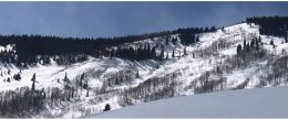
Avalanches: Everywhere in sight, especially E facing terrain. D1-D2+ on virtually any alpine feature which took on drifting recently, along with some unusual NTL/BTL features which normally wouldn’t be suspect. Most of the recent avalanches we observed today have already been reported, but not all of them. Basically, if you looked below a cornice on a leeward aspect, it went big. Sorry, no pictures.
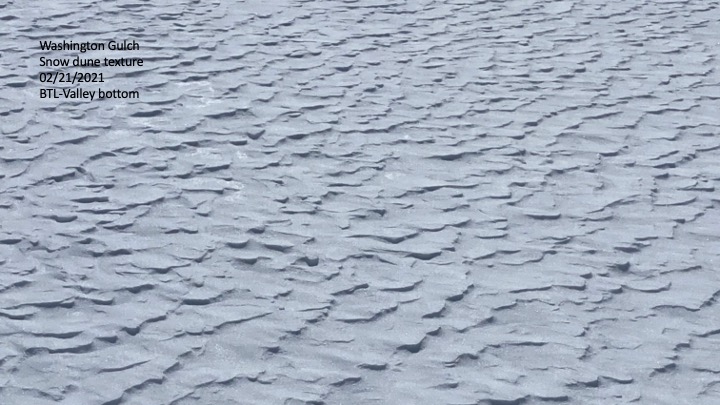
Weather: Windy. Steady and swirling winds, mainly out of the W/SW at 10-20 mph all day. Probably was gusting to 30+ at higher elevations based on the flagging we observed off many of the surrounding peaks. Air temp wasn’t as cold as we expected this morning. My car read 18F at TH at around 9am. Apart from the consistent and gusty strong winds, air temp seemed pretty mild for the majority of the day.
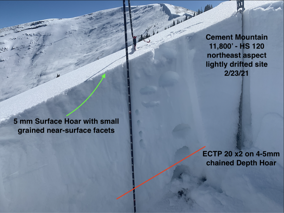
Snowpack: Mainly traveled on W/NW BTL and NTL, but also had a quick transition on a southerly aspect NTL. Snowpack depth was relatively uniform. Pole probes went to ground at 110cm-130cm. On the ridgeline, where the wind has stripped the majority of the season’s snowpack, depth was around 30cm. Snow was supportive on all aspects we traveled, with a ski pen of around 3-6.” Once we stepped off our equipment though, boot pen went to ground with full weight. For the most part, the skiing was surfy and supportive. However, variable crusts exist on the sunny aspects and wind-affected terrain, of course.


Mountain Snowpack-Cooperative Snow Survey Program for NRCS

CB Avalanche Center2020-21 Observations

Date of Observation: 02/26/2021
Name: Andrew Breibart


Zone: Southeast Mountains
Location: Red Lady Glades and CB Nordic Trail
Elevation: BTL

Weather: Keystone snow course/Red Lady Glades: obstructed skies and strong winds. colder temperatures before 9AM
Crested Butte snow course/CB Nordic Magic Meadows yurt: few clouds and light winds with moderate gusts and warming temperatures between 10 AM and 12PM.
Snowpack: Keystone snow course: 2.54 cm (1 inch) melt-freeze crust on the surface. Snow depth ranged between 68 and 112 cm (27 and 44 inches) across 41 meter (135 foot) transect with 5 samples.
Crested Butte snow course: depth ranged between 86 and 107 cm (34 and 42 inches) across N to S transect of 122 meters (400 feet) and W to E transect of 74 meters (244 feet). melt freeze crust 61 cm (24 inches) below surface (1/19 or 2/5 interface?).


Photos:

Some good, some bad, all hot

CB Avalanche Center2020-21 Observations

Date of Observation: 02/25/2021
Name: Wallace Cleaver


Zone: Northwest Mountains
Location: Slate
Aspect: North East
Elevation: ATL-BTL


Avalanches: Couple of wet slides that pulled out as point releases from below rocks on east tilt below treeline just above valley floor. Then all of the other ones documented in the area from a couple of days before. Of note, looked at the one in the palace and the avalanche had roared through some pretty dense trees causing some pause as to what true islands of safety really are.
Weather: Good, if you’re into sunny and warm. I prefer cloudy, snowy and cold though. Nuclear (or nucular as Dubyah used to say) in the valley floor.
Snowpack: NE aspect most of the way along the ridge had a serious windboard complete with that spooky hollow sound. Further down the ridge snow surface softened.
Below treeline soft with a couple clips of windcrust and easterlies had suncrurst. A lot of snow pulled out in the avalanches in the palace area, back to hitting some rocks toward the bottom, you know like back in December…


Cement Mountain loop

CB Avalanche Center2020-21 Observations

Date of Observation: 02/23/2021
Name: Jack Caprio and Eric Murrow

Zone: Southeast Mountains
Location: North Cement Mountain
Aspect: North, North East, East, West, North West
Elevation: 9,000′-12,200


Avalanches: Observed a number of avalanches on Cement Mountain of varying ages from the past month.  Included images for avalanches that likely failed around the Feb 13/14 time frame.  Most of these avalanches failed on drifted features with two below treeline on non-drifted slopes.  Looking around leeward features in Southeast Mountains did not see any other recent avalanches.  While driving pavement in afternoon, I spotted a couple very small loose avalanche on Gothic Mountain coming out of steep, rocky southerly features.
Weather: A cold early morning in the canyon quickly gave way to warm, sunny weather. Above treeline, W and NW winds blew at consistent moderate speeds with high gusts.

Snowpack:  Toured up and over Cement Mountain.  This is a relatively shallow snowpack area as it is in the Southeast Mountains and receives less snow volume than other areas in Southeast Mountains due to its location.

Below 10k, the snowpack consisted of generally 80 cms of thin crust/ facet combos. When HS was less than around 80 cm, ski pen was to the ground. As we increased in elevation to about 10K-ish, HS increased above 80 cms to around 100cm and the snowpack thankfully began to support the weight of a skier while breaking trail. We didn’t get any alarming signs of instability as we were making our way up through the trees on N aspects below treeline.

As we got near and above treeline, we continued to see W and N winds transport snow onto leeward start zones. A snowpit test on a slightly windloaded, NE-facing aspect near treeline produced moderate propagating results. We did get one large rumbling collapse while traveling on ridgeline, adjacent to the NE facing start zones. The collapse did not produce any cracks but it was loud enough to hear over the blustering winds. Much of the avalanche paths we traveled above had already slid during the last 3 weeks. Most of the bed surfaces had not refilled enough to slide again. We chose not to ski any of the slopes that had previously avalanched because of the low quality of skiing, not necessarily avalanche hazard.  Briefly touched a few below treeline sunny slopes that were moist but not wet enough to cause Wet Loose concerns due to winds keeping surfaces relatively cool.


Photos:

[/gravityforms]

Cement Creek

CB Avalanche Center2020-21 Observations

Date of Observation: 02/22/2021
Name: Cosmo Langsfeld


Zone: Southeast Mountains
Location: Middle cement creek
Aspect: East
Elevation: ~10k’

Avalanches: Small, fresh looking crown on same path that slid across cement creek road a little while back. Photo from Monday afternoon.


Photos:

tender is the pack..

CB Avalanche Center2020-21 Observations

Date of Observation: 02/21/2021
Name: jeff banks


Zone: Southeast Mountains
Location: gothic road at S curve
Aspect: South East
Elevation: 9550


Avalanches: none
Weather: howling & cold all day, heavy transport drifting upslope from NE and loading top of California bowl (transport from the bottom) forming a new ~3ft cornice @ 10,800 on the blunt ridge in a break in the trees
Snowpack: 1 medium whumpf in heavily ski tracked conifer forest above weather station plot meadow @ 10,700

Propagation on PST X 2 on Gothic Road SE @ 9550
45/100 END down 70cm Failed on 4mm FC F hard 20cm above ground interface w/ MFCR Knife to 1F slab HS 100cm
40/110 END Same-Same


Snodgrass/Gothic

CB Avalanche Center2020-21 Observations

Date of Observation: 02/22/2021
Name: Frank Stern

Zone: Southeast Mountains
Location: Snodgrass/Gothic
Aspect: North East, East
Elevation: 9,500-10,500

Avalanches: One looks like a natural release today, crown maybe 100′ long, east and below California bowl, D2. One or two (might have all happened at once in 2nd bowl, combined width 500′ or so, ran 700-800 feet. One on lower East of Gothic.   CBAC Note: Some of these may have run earlier in the cycle (ob A, ob B).  Hard to keep track of all the crowns on Snodgrass.
Weather: Sunny
Snowpack: Some wind and sun crust, mostly soft.

Anthracite Mesa-Coneys

CB Avalanche Center2020-21 Observations

Date of Observation: 02/21/2021
Name: Andrew Breibart


Zone: Southeast Mountains
Location: Washington Gulch-Coneys
Aspect: North East, East
Elevation: BTL


Avalanches: From Coney’s ridge line observed an avalanche on Schuylkill. Appears to be a a wind slab with a D2 on damage scale. NTL on East aspect. photo attached and didn’t see it any photos from 2/13-2/15. Maybe this occurred between 2/19-2/21.   CBAC note: this slide was first observed 2/15, but documented from a poor vantage point.
Weather: Moderate winds with strong gusts. Lots of blowing snow especially in the valley bottom. See dune photo. Negligible snow was being transported along the ridge line.
Snowpack: Measured snowpack in an open area below the trees down gradient of first bowl: snow depth ranged between 140 and 155 cm.
Ridge top: ski pen- 4 inches and boot pen was 9 inches. HS ranged between 135 and 150 cm.
new snow was around 2 inches.
leeward side of ridge line had new snow between 4 to 6 inches.


Photos:

Washington Gulch Avalanches

CB Avalanche Center2020-21 Observations

Date of Observation: 02/20/2021
Name: Marcel Medved


Zone: Northwest Mountains
Location: Washington Gulch near Elkton
Aspect: South, West
Elevation: 10,400-10,600


Avalanches: Wind loaded, fresh slides on Friday? West Side of Gothic Mtn. Photo does not show very well.
South Side of hill above Mosquito Hut.  CBAC Note:  These slides were first observed 2/14.
Weather: Saturday 9:30am, sunny, calm 20F
Snowpack:


Photos: