Date of Observation: 03/05/2021
Author: Jack Caprio
Zone: Crested Butte Backcountry
Spring break is upon us. Temperatures are climbing and our snowpack has begun the annual springtime transition. See all the recent action here.
Date of Observation: 03/05/2021
Author: Jack Caprio
Zone: Crested Butte Backcountry
Spring break is upon us. Temperatures are climbing and our snowpack has begun the annual springtime transition. See all the recent action here.
Date of Observation: 03/05/2021
Name: Jared Berman, Zach Kinler
Zone: Northwest Mountains
Location: Anthracites
Aspect: North, North East, South East, South
Elevation: 10,000′- 11,500′
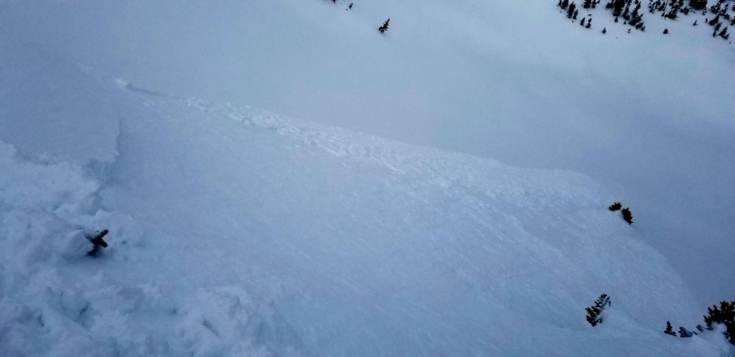
Avalanches: From a distance, we could see several small loose wet avalanches initiating below rock bands on steep east and southeast facing terrain in Elk Basin and Evans Basin near treeline.
In the Anthracites, one D1.5 natural loose wet was observed below treeline on a southeast slope while another was intentionally triggered on a south facing slope. Both ran into the basin locally known as the Playground (see photos below).
Weather: Clear skies, calm winds, and above freezing temperatures.
Snowpack: Drastically variable snowpack depending on aspect below treeline and near today.
On north and northeast facing slopes, probing revealed the average snowpack depth being 150cm deep with some areas as deep as 200cm. We measured 8″ of new snow on these slopes with 0.75″ of snow water equivalent. We did observe faceted grains at the old/new interfaced as well as small faceted grains at the snow surface.
On south and southeast facing slopes below treeline, the snowpack averaged 90cm deep. A hasty pit revealed moist snow all the way down to the ground with obvious signs of free water(vertical and horizontal ice columns) through the upper half of the snowpack.
Photos:


Date of Observation: 03/05/2021
Name: Andrew Breibart
Zone: Southeast Mountains
Location: Washington Gulch-Coneys
Aspect: North East, East
Elevation: BTL
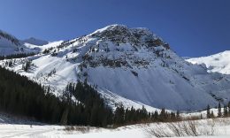
Avalanches: photo 1. wet loose avalanches the NW zone observed on Schuylkill ridgelines. SE aspect ATL and BTL.
photo 2. natural D1 slab (persistent slab (?) avalanche below rock band entrance to Wolverine Bowl). NE aspect at NTL.-maybe captured in earlier obs.
no photo: on drive into town, I observed a D1 slab on E/SE aspect in Red Coon Bowl BTL.-maybe captured in earlier obs.
Weather: in the open, it was a sauna with high UV’s from the high albedo. calm. few clouds
heat relief relief in the trees.
Snowpack: 2 to 4 inches of recent snowfall.
on lee side of the ridge, boot pen was 14 inches and ski pen was 4 inches.
skiing was fun but there is a melt freeze crust on the open east aspects at BTL.
Photos:


Date of Observation: 03/04/2021
Name: Evan Ross
Zone: Northwest Mountains
Location: Washington Gulch
Aspect: East, South East, South, South West, West
Elevation: 9,400-11,400
Weather: Good Pulse of snow in the morning, then waited most of the day for things to pick back up. Headed out in the late afternoon. Periods of heavy snowfall. Mostly calm winds with some strong gusts.
Snowpack: A couple of inches of new snow near the Washington Gulch Trailhead, and about 5 inches of new snow near the head of Washington Gulch. In the alpine there may have been a little drifting and some slab formation, otherwise where I traveled the new snow didn’t make any change. Small sluffs on steep northerly-facing slopes would be about it. I didn’t find enough snow to sluff on the crusty southerly-facing slopes.
The recently buried crust on southerly-facing slopes was a couple of inches thick. Boot pen mostly punched through the crust to about 30cm. Interestingly, most of those crusts also had percolation columns extending into moist or even dry snow below.
Sunny slopes are setting up nicely for a loose wet avalanche cycle when the sun comes out, otherwise, the new snow is mostly adding to sluffing volume on northerly-facing slopes.

Date of Observation: 03/03/2021
Zone: Southeast Mountains
Location: South face of Gothic Mtn.
Aspect: South
Elevation: 12,000-11,000
Avalanches: Skier triggered shallow, slow moving, long running wet slide running on a hard crust 12 inches deep.
Weather: Sunny with little to no wind. Temps reaching upper 30’sF.

Date of Observation: 03/03/2021
Name: Jack Caprio
Zone: Northwest Mountains
Location: Beckwith Pass
Aspect: North, North East, East, South East, South
Elevation: 10k-11k
Avalanches: Older D.5-D1 loose wet avalanches on E and SE aspects which likely ran over last couple days. We did not stick around long enough to see any new activity.
Weather: Bluebird and very warm.
Snowpack: Steep, east facing snow surfaces were noticeably moist at 10,200k at 9:00 am. Around 10 am on south facing slopes at 11k, the surface crusts just barely still supported the weight of a skier, and we’re beginning to soften up quickly. We ended up skiing NE facing slopes which stayed dry.
Photos:


Date of Observation: 03/02/2021
Name: Evan Ross Zach Kinler
Zone: Southeast Mountains
Location: Slopes near CB
Aspect: North East
Elevation: 8,900-9,500
Weather: Blue bird and sunny. Snow surfaces stayed cold where we traveled.
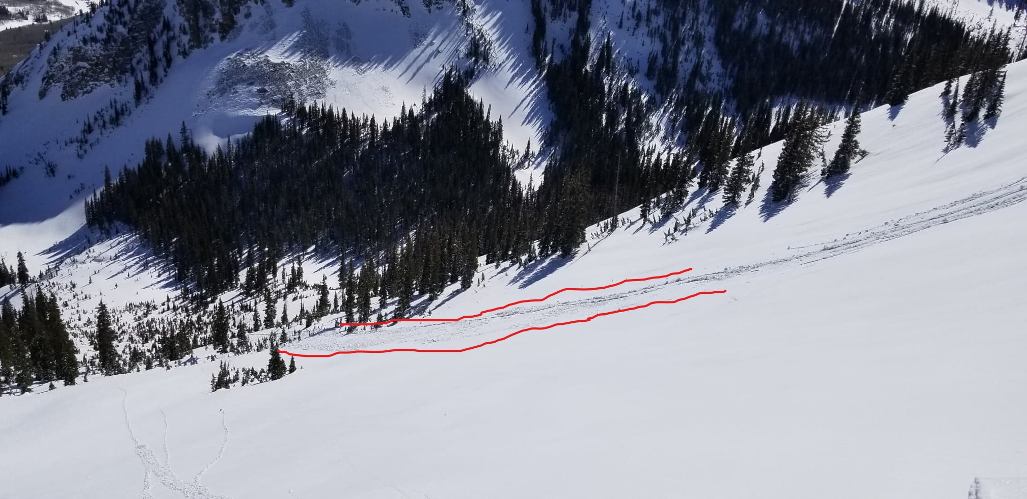
Snowpack: The sandbox is trying to come back, but thankfully it’s just the surface snow for now. The top 20cm of the snowpack was faceted and weak. That made for some nice soft turns, slippery skinning, and fuel for small loose snow avalanches.
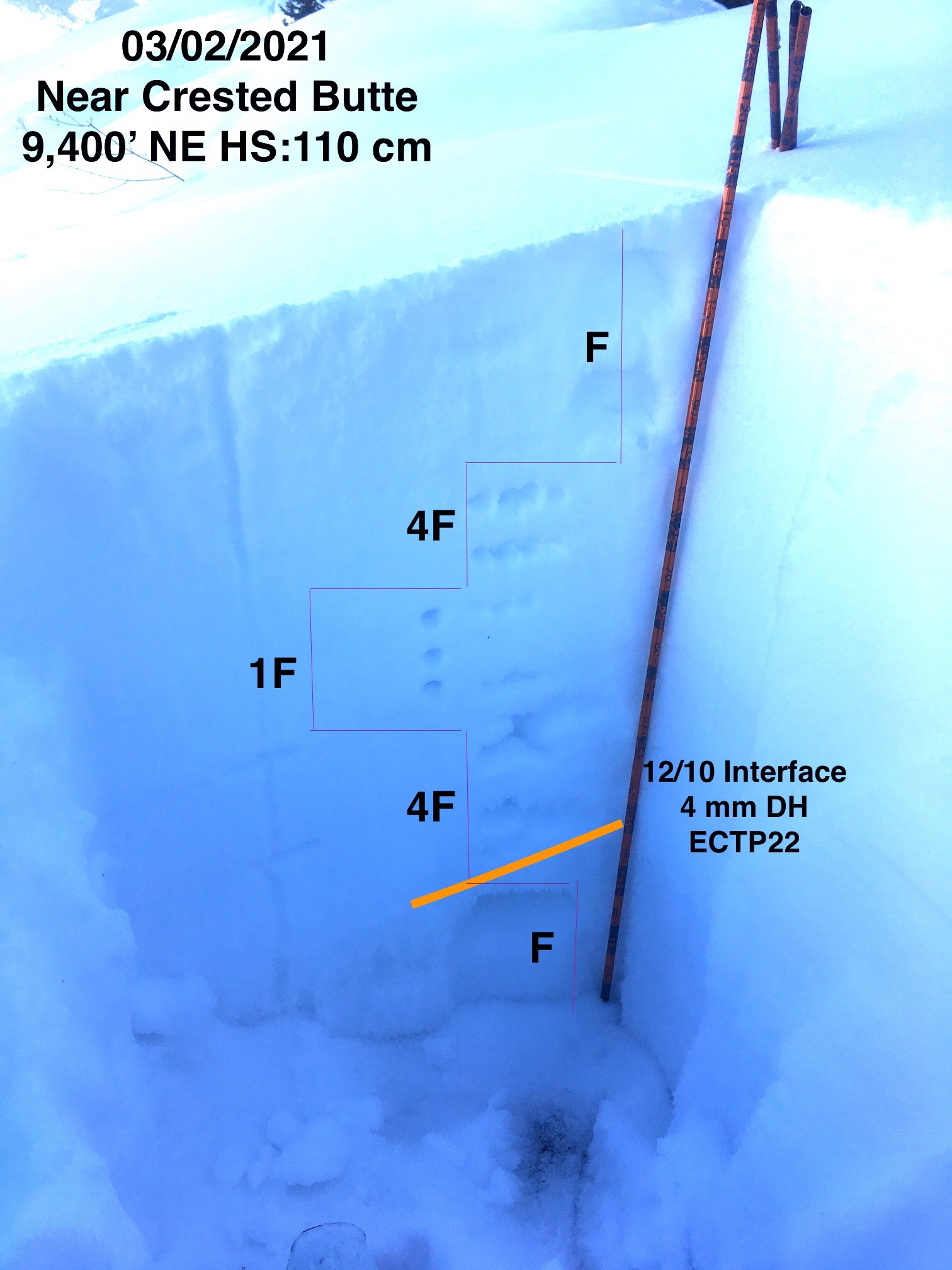
We were hunting for a below treeline, NE facing snowpack, with a total snowpack height in the 100-120cm range. That’s just what we found and the end goal was to get more data about the current persistent slab problem. The PSa structure across an individual slope was variable. Sometimes complexly weak, and sometimes a 1F mid-pack above the 12/10 facets. So we could sum up that avalanche problem as “Isolated” in the terrain.
For test results. We observed no signs of instability while traveling on slopes in the mid-30 degree range. We tried doing the standing jump thing, hitting some other jumps, taking a ski off and punching… quiet. We dug two pits at locations with 1F mid-pack over the lower layers of concern. ECTX and ECTP 22 on 12/10 interface. We would estimate the sensitivity to fit “Stubborn” more than “unreactive”. Put a bunch of snowmobiles or skiers on the same slope and there are a couple of spots that they may just produce a large slab avalanche.

Date of Observation: 03/02/2021
Zone: Southeast Mountains
Location: 3rd Bowl
Aspect: North East
Elevation: 10,800
Avalanches: Triggered a couple small sloughs and a small slab approximately 15 ft wide 8” deep crown in the more northerly trees knocking over a skier.
Weather: Pretty rapid warming through the morning
Date of Observation: 03/02/2021
Name: Alan Bernholtz
Zone: Northwest Mountains
Location: Coneys nose
Aspect: North East
Elevation: 10,800
Avalanches: Small loose snow sluff avalanche right off the top. 15 cm deep on 33 degree slope. 40’ wide by 80 feet long.
Weather: Clear with a light westerly breeze. Temp was in the 20’s
Snowpack: 70-80 cm total height of snowpack. Fist on top with a density change in the mid pack to fist+ then large grain facets at the bottom. The surface facets slid on the density change. Fairly predictable.
Photos:

Date of Observation: 02/27/2021
Name: Jared Berman, Zach Guy Jack Caprio
Zone: Northwest Mountains
Location: East Bowl of Schuylkill Mountain
Aspect: North East, East
Elevation: 9,300′ – 11,100′
Avalanches: We intentionally triggered 3 small (D1) wind slabs on skis. Slabs ranged from 3″-6″ deep and were relatively harmless to a person. No recent naturals were observed today.
Weather: Weather started off overcast with light winds from the west below treeline. As we traveled clouds broke apart enough to see surrounding terrain and mountains. Moderate winds existed near treeline and we observed active wind transportation from some ridgetops and trees.
Snowpack: Persistent slab structure still exists on northeast aspects below treeline, capable of propagating deep failures. A snowpit at 9800′ on a northeast aspect revealed a 140cm hard slab (1 finger to pencil in hardness) resting on top of weak 2-3mm depth hoar at the ground (12/10 interface). The bottom of the slab contains rounding facets (1/19 interface) that appear to be gaining strength and were not as reactive as the 12/10 interface when comparing two propagation saw tests. See photo below of the snow profile with propagation saw test results.
Surface instabilities was a whole ‘nother ball game. Shallow wind slabs existed on isolated features near treeline and were reactive under skis. Slabs were small though ranging from 3″-6″ deep. We did not observe wind slab size or distribution above treeline as we did not travel at that elevation.
Photos: