Mt Emmons Tour

CB Avalanche Center2016-17 Observations

Location: Crested Butte Area
Date of Observation: 12/18/2016
Name: Seth Beers
Subject: Mt Emmons Tour
Aspect: East, South East
Elevation: 9200 – 12200

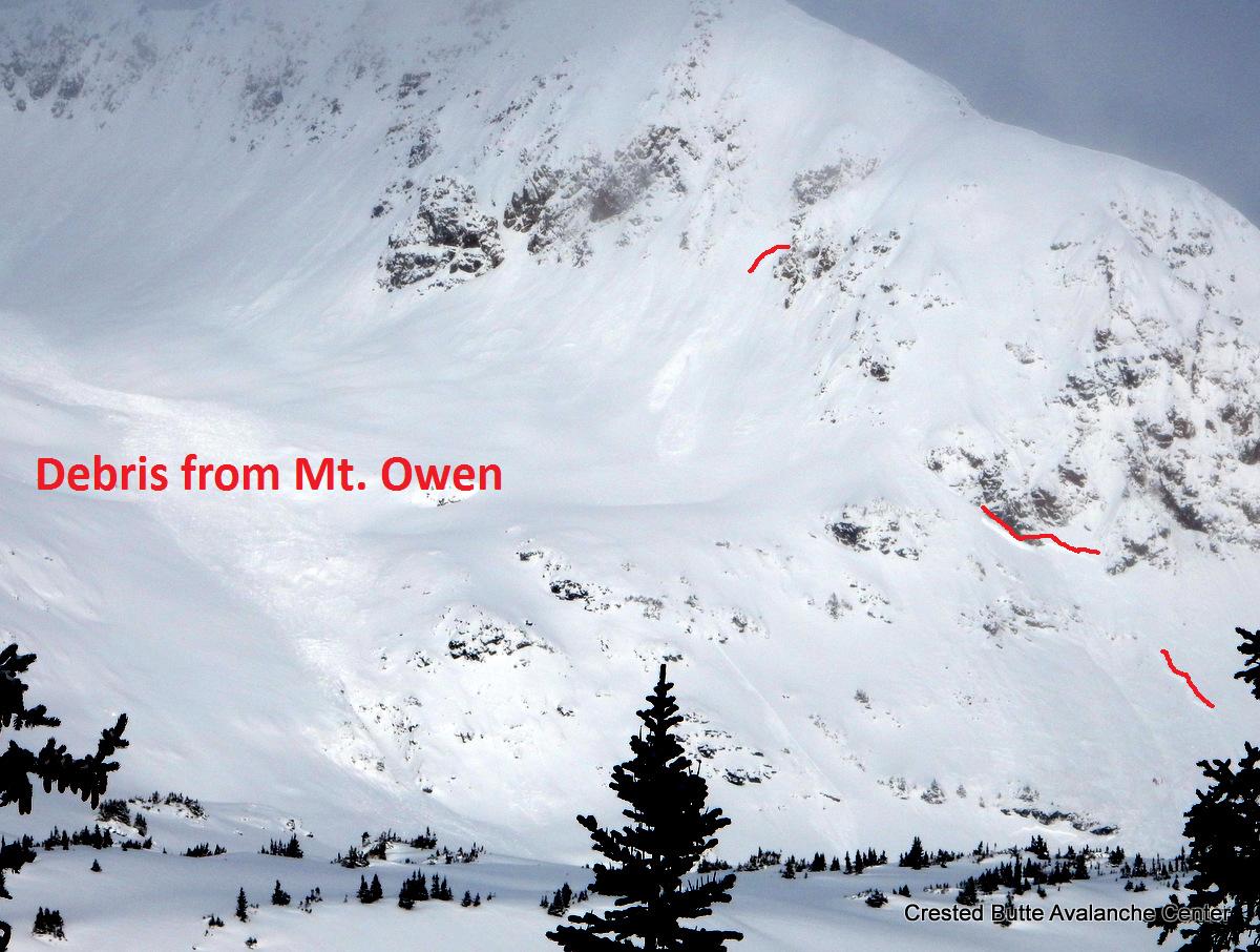
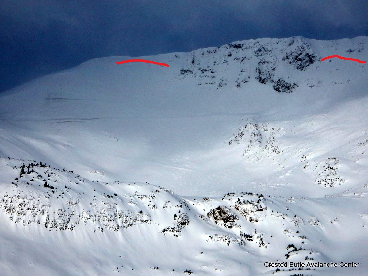
Avalanches: 2 natural avalanches observed (see photos), east facing. Did not dig to check interface but suspect they may have run on crust layer.
#1: 11,200′, 40 – 50 cm crown; ~35*; 150’w x 250′; R2-D1.5 (likely ran mid-storm)
#2: 10,800′, 40 – 60 cm crown, ~40*; 250’w x 200′; R2 – D2 (fresher crown, likely ran at end of storm)

Got one, small localized collapse in open meadow at ~10,000′. Took inserting tail of my ski thru storm slab to get the result.
Weather: Clear, Cold
Temp: 8F @ TH @ ~1030; slight inversion
Winds: Calm, slight upslope winds on occasion
Snowpack: Ski Pen: 10cm – 20cm
Highly variable snowpack depth with slab from weekend storm present at all elevations and aspects (E-SE) during tour and consistently supportable. Storm slab frequently sat on top of a sun crust in exposed areas higher in elevation – will be a good interface to observe. Coverage was adequate except some of the most wind exposed areas with no “ground” encounters while skiing.

IMG_0046
IMG_0048

Mountain Weather 12/19/2016

CB Avalanche CenterWeather

Date: 12/19/2016

Dry and cold conditions are the name of the game for the start of this week. It’s -22 in CB this morning with cold air pooling in the valleys, but if you climb into the mountains at 11,000ft, the low temp is closer to 0. We’ll see high temperatures rebound into the twenties over with calm conditions over the next couple of days before clouds increase Tuesday afternoon ahead of a weak shortwave trough passing to our north. Northern Colorado should eek our a few inches while central Colorado looks to be mostly dry. Had you chosen to live in North Dakota you would have a better snow forecast, but instead you chose to live in Crested Butte. The latter part of the week looks dry again before a return to stormy weather on Friday or Saturday. We’ll have to wait for later forecast models for details about this event.

Avy 1 Gothic

CB Avalanche Center2016-17 Observations

Location: Crested Butte Area
Date of Observation: 12/18/2016
Name: Evan Ross
Subject: Avy 1 Gothic
Aspect: East, South West, West
Elevation: BTL 10,200-9,500

Avalanches: Plenty of natural avalanches to be viewed on Sunday, all that released during the recent large loading event. All had started filling back in or were viewed from to far to correctly code. Of note, vary large slab on the SE bowl of Bellview, numerous slabs on the east face of Gothic, large and far running slab in the Spork or SE bowl of Gothic, Slab on the SE bowl of the White Massive, several slabs below treeline on northeastern aspects of Snodgrass.
Weather: Saturday: Mostly cloudy and freezing cold. Sunday: Mostly clear and freaking cold. Few strong gusts in the valleys on Saturday and calm winds on Sunday.
Snowpack: Saturday:
Toured on small slopes near the valley bottom. Snowpack structure didn’t chance much from east facing to west facing, 2mm acted grains on average near the ground 10-20cm thick. Some intresteing thin strips of faceted polycrals? in there to mix things up. Maybe from an early season rain event or previous moist facets. Never the less some good collapses and shooting cracks on this layer while traveling on slopes less then 31 degrees.

Sunday:
Low elevation snodgrass tour, on slopes less then 33 degrees. Similar structure as the previous day. No obvious signs to instability. Conditions felt more stubborn.

Debris above Gothic Road from a large slab in the Spork or SE bowls of Gothic.

IMG_2425

Bellview crown conceted via multiple aspects and elevations.

IMG_2424

Numerous slabs and crowns on the eastern side of Gothic. All being filled back in and currently discrete without zooming in.

IMG_2420

Shooting cracks on a SW facing slope in the Gothic valley.

IMG_2411

Avy cycle obs as viewed from Snodgrass

CB Avalanche Center2016-17 Observations

Location: Crested Butte Area
Date of Observation: 12/18/2016
Name: Zach Guy
Subject: Avy cycle obs as viewed from Snodgrass
Aspect: South West
Elevation: 9600-11000

Avalanches: See photos. Plenty of evidence of widespread natural avalanche cycle that ended Saturday morning. The most widespread activity was above treeline on leeward or crossloaded slopes, ranging from D2 to D3 in size. Most of the “frequent flyers” below treeline (Happy Chutes, Gibson Ridge, Meridian Lake, etc) held tight except for smaller storm slab action.
Weather: Cold, clear, calm.
Snowpack: 40 cm of F+ storm snow below treeline on SW aspect, on a thin crust. Easy, propagating test results on a mid-storm density difference. We got a few minor collapses while breaking trail below treeline, and one large collapse as we reached more of a near treeline elevation at ~11,000 ft.

Climax Chutes.  NE aspect NTL.

Climax Chutes. NE aspect NTL.

Scarp Ridge.  NE aspect ATL

Scarp Ridge. NE aspect ATL

Wolverine Basin. NE aspect ATL

Wolverine Basin. NE aspect ATL

Mt. Axtell. NE aspect ATL

Mt. Axtell. NE aspect ATL

Gothic Peak.  SSW aspect ATL

Gothic Peak. SSW aspect ATL

Mt. Baldy.  SE aspect ATL

Mt. Baldy. SE aspect ATL

Coon Basin. SE aspect ATL

Coon Basin. SE aspect ATL

Washington Gulch. E aspect BTL.  Snowplow triggered?

Washington Gulch. E aspect BTL. Snowplow triggered?

Nordic hill. NE aspect (skier triggered?)

Nordic hill. NE aspect (skier triggered?)

Skier triggered slide on Red Lady Bowl. SE aspect ATL

Skier triggered slide on Red Lady Bowl. SE aspect ATL

SW aspect BTL.

SW aspect BTL.

Redwell Basin.  N/NE aspects ATL

Redwell Basin. N/NE aspects ATL

Purple Peak. East aspect ATL

Purple Peak. East aspect ATL

Purple Ridge and Purple Peak.  NE aspects ATL

Purple Ridge and Purple Peak. NE aspects ATL

Schuylkill Peak. NE aspect ATL.

Schuylkill Peak. NE aspect ATL.

Red Lady Skier Triggered Avalanche

CB Avalanche Center2016-17 Observations, Accidents, Avi-map 16-17

Location: Crested Butte Area
Date of Observation: 12/18/2016
Name:
Subject: Red Lady Skier Triggered Avalanche
Aspect: South East
Elevation: Above treeline

Avalanches:

Watched 4 skiers ski the bowl from my house via a telescope around 12:30 PM. It appears they didn’t encounter any stability issues.

Then watched a lone skier top out at 3:20 PM. He traversed another 50 or so yards east along the summit ridge past the entry point of the 4 earlier skiers, and then dropped in. He had made 10 or so turns, and then it happened; a majority of the bowl ripped out above him, almost edge to edge. Luckily at this point he had skied skier’s right of his drop in point, and had re-joined the 4 tracks from earlier.

It appeared he was ‘slightly’ caught in some sluff before skiing down to a narrow island of the slope that didn’t slide (that spot is very visible). He stopped in the middle of all the chaos as the slide ran on both sides of him, far down the slope where it eventually reconnected as it continued down the bowl.

The slide was well past him and he was skiing down when I lost sight of him. I lost sight of him, but counted 5 tracks (4 plus his) after the slide. So I ‘think’ he was OK. Close call.

***CBAC Note*** We are all very grateful that the swath of snow in the middle of the bowl did not slide in this incident. We want to dispell any beliefs that this commonly skied portion of the bowl is a “safety island”.   Last December, a similar type of avalanche broke across the whole bowl.  See photos below.
Weather:
Snowpack:

red-lady-dec-18-2016

Red Lady Bowl. Photo courtesy of Ben Pritchett

12/18. Close call on Red Lady Bowl.

12/18. Close call on Red Lady Bowl. Photo courtesy of Chris Miller.

12/18 Skier triggered persistent slab in Red Lady Bowl

12/18 Skier triggered persistent slab in Red Lady Bowl.

12/18 Red Lady . Photo courtesy of Dustin Simoens

12/18 Red Lady. Photo courtesy of Dustin Simoens

Extent of 2015 natural avalanche in Red Lady Bowl.

Extent of December 2015 natural avalanche in Red Lady Bowl.


Mountain Weather

CB Avalanche CenterWeather

Date: 12/18/2016

Cold is the name of the game today as northwest flow keeps our mountains blanketed in an arctic airmass. Valley temps are hovering around -10 this morning, and it’s only 5 to 15 degrees warmer in the mountains. If those temps aren’t cold enough, head over to Taylor Park, where the mercury is dipping towards -20. Temperatures will barely climb into the single digits today under partly cloudy skies. Looking ahead, a dry, warming trend will carry us through Monday and Tuesday. A shortwave on Tuesday night brings a quick shot of snow, and then a more powerful Pacific trough takes aim for the end of the work week.

Naturals in Ruby Range

CB Avalanche Center2016-17 Observations

Location: Kebler Pass Area
Date of Observation: 12/17/2016
Name: Zach Guy
Subject: Naturals in Ruby Range
Aspect:
Elevation: Near, Above treeline

Avalanches: Numerous large natural avalanches observed around the Ruby Range that ran sometime in the past 24 hours, on various aspects near and above treeline. Unknown failure layers, crowns generally appeared to be 2 to 4 feet thick, D2 to D2.5 in size. A lot of crowns and debris piles were smoothed over by wind and snow and hard to recognize. The most impressive was a crown across Mt. Owen’s East face, at least 1500′ wide and appeared to be 8+ feet deep in places, D3 in size.   See photos.
Weather: Temps dropped through the day to 8F. Broken skies. S-1. Light winds, with a few short-lived moderate gusts.
Snowpack: Storm board: 26″ (3.85″ SWE). 1″ during the day today.
Wind transport and settling new snow has made the upper snowpack stiffer and supportive. Ski pen only ~6″ today. We primarily traveled on heavily boot packed, ski trafficked, and explosively mitigated terrain, with minimal signs of instability. In low angle areas facing S, SW that had not seen packing or explosives, we got 3 large collapses.

D1.  SE aspect NTL

D1. SE aspect NTL

D2.  SE aspect Purple Peak

D2. SE aspect Purple Peak

D2.5  E aspect of Mt. Owen

D2.5 E aspect of Mt. Owen

D2.5 debris pile below south face of Mt. Owen

D2.5 debris pile below south face of Mt. Owen

1500'+ wide crown on Mt Owen, NE to SE face. Looks 8'+ deep.  D3

1500’+ wide crown on Mt Owen, NE to SE face. Looks 8’+ deep. D3

D2. South aspect of Peeler Peak

D2. South aspect of Peeler Peak

D1.5. South aspect of Peeler Peak.

D1.5(?). South aspect of Peeler Peak.


Natural Avalanche Activity

CB Avalanche Center2016-17 Observations

Location: Crested Butte Area
Date of Observation: 12/17/2016
Name: Various 2nd hand observations -ZG
Subject: Natural Avalanche Activity
Aspect:
Elevation:

Avalanches: Large naturals on Belleview , Whetstone, White Mtn (Zachary’s path)
Weather:
Snowpack:

Avalanche Mitigation work

CB Avalanche Center2016-17 Observations

Location: Crested Butte Area
Date of Observation: 12/17/2016
Name: CB Patrol
Subject: Avalanche Mitigation work
Aspect: North, North East, East
Elevation: BTL

Avalanches: BTL on N-E aspects several small road cuts’ came out’ with ski cuts and explosives failing on the ground in terrain over 38 degrees. In terrain under 38 degrees, failure occurred in the upper 20 cm of the pack on graupel layer.

ATL NNE aspect 11,500-11,300 Big Chute/Paradise Cliffs:2x HS-AE-R3-D2-O/G. These slides were stubborn to trigger but when tested with explosives produced failures to the ground in terrain steeper than 35 degrees.
Weather: P/C
Snowpack: In the East River sector of CBMR: Depth of snow 80-110cm. New snow (40-60cm) sitting on top of a variety of facets. A graupel layer 20 cm down was the reactive problem layer of the morning BTL on N-E aspects. Lots of collapsing and cracking. Some cracks were depth of snow pack where the wind effected the slope, all in the top 20 cm of the snowpack.

Gothic 6 a.m.

CB Avalanche Center2016-17 Observations

Location: Crested Butte Area
Date of Observation: 12/17/2016
Name: billy barr
Subject: Gothic 6 a.m.
Aspect:
Elevation: Below treelin

Avalanches: I could hear slides yesterday but as none hit me I did not see anything. The wind will accelerate the slide activity but should also help snow set up a bit faster. Once (if?) we get some visibility again I will let you know what I see.
Weather: Oh my. The unheard of (for here) dense snow continued with 12″ new snow and water of 1.14″. The snow substantially let up in the afternoon and then stopped, though light overnight. But after sunset the wind took over with steady 15-20 W gusting in the 30’s until slowing don around 2-3 a.m. Snowpack at 43½” as currently obscured cloud cover with very light snow and light wind.

This makes day 21 in a row with just 1 clear or partly cloudy day, and it is OLD. billy
Snowpack: