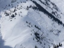
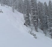
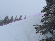
Kebler BTL no signs instability

CB Avalanche Center2020-21 Observations

Date of Observation: 03/15/2021
Name: jeff banks

Zone: Northwest Mountains
Location: Kebler
Aspect: North
Elevation: up to 10,600

Avalanches: none
Weather: cool
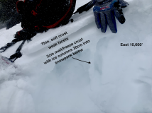
Snowpack: no signs of instability on small test slopes up to 40* N facing sheltered in forest.
~12″ of settled pow, well bonded to old snow.
HS 135cm-155cm

Gothic 7am Weather Update

CBAC2020-21 Observations

Date of Observation: 03/16/2021
Name: billy barr

Zone: Southeast Mountains
Weather: Probably the most snow we received during this whole storm was from 5 to before 7 a.m. this morning with 2″ new, but then only 0.11″ of water with it. The 24 hour total was 3″ new with 0.15″ of water and snow pack is at 44½” deep. Mild with the high 36F, low 11 and current 18. Currently cloudy with light snow and no wind.

I don’t mind cut-off lows

CBAC2020-21 Observations

Date of Observation: 03/15/2021
Name: Zach Kinler
Zone: Northwest Mountains
Location: Kebler Pass area
Aspect: North, North East
Elevation: 9,000′-11,200′

Avalanches: No new avalanches observed skies were overcast with limited vis into the surrounding terrain.

Weather: OVC, sporadic light snow showers throughout the day amounted to little additional accumulation. Winds were calm below tree line and very light near tree line. Temps remained below freezing.

Snowpack: Measured 8″ of new snow overnight which was very low density, around 3%-4%. 2 day HST in this zone is now 22″/~1.25″ SWE. Hand shear tests were breaking above the new/old interface at a density change. No signs of instability were noted while skiing slopes up to 38 degrees in this terrain. Minor cracking was observed in the deepest drifts near tree line. No results ski cutting slopes that produced small slab avalanches yesterday in this terrain as storm and wind slab instabilities are settling out.


Nice Little Refresh

CBAC2020-21 Observations

Date of Observation: 03/15/2021
Name: Evan Ross

Zone: Northwest Mountains
Location: Washington Gulch
Aspect: All
Elevation: 9,000-11,300ft

Avalanches: Had some fairly good views of lots of terrain and didn’t note any new avalanches. Still lots of old avalanches from last month waiting to get buried.

Weather: Clouds cleared a bit throughout the day. Periods of light snowfall during the day put down some nice goose feathers. Didn’t see much for drifting during periods of visibility, but also didn’t spend a lot of time in exposed terrain.

Snowpack: Touched all the aspects, but primarily traveled on northerly facing slopes below treeline where the best riding was. At 11,000ft and on shaded slopes, storm totals were currently settled to about 6″. On sunny slopes or at lower elevations storm totals were 1 to 4″ on average. So Kebler clearly got a bit more snow out of this storm. We didn’t encounter any new avalanche problems.

In the late afternoon, I spent a little time at an 11,300ft near treeline point. Here I found isolated drifts up to 10″. Hunting around for a more notable snowpack ob didn’t produce in that area. The new snow was getting thicker and/or baking in on East, South, SW at this location.

Anthracite Mesa-Coneys

CB Avalanche Center2020-21 Observations

Date of Observation: 03/15/2021
Name: Andrew Breibart

Zone: Southeast Mountains
Location: Coneys
Aspect: North East, East
Elevation: BTL

Avalanches: NA-poor visbilility.

Weather: Skin up: S1 snowfall with a trace of new snow accumulation. Calm. Temperatures were around freezing. Cloud cover was obstructed.
Descent: mostly cloudy and calm.

Snowpack: 1 to 3 inches of new snow in the skin tracks. Observed about 3 inches of new snow on the ridge and on the leeward side of the ridge, there were 6 inches of snow. Skied between 1st bowl and Convex corner and snow was very supportive. One ski partner observed cornice formation above first and second bowl.

Kebler Pass stuff

CBAC2020-21 Observations

Date of Observation: 03/14/2021
Name: Eric Murrow


Zone: Northwest Mountains
Location: Anthracites
Aspect: North, North East, East, South East, South
Elevation: 9,200′ – 11,300′


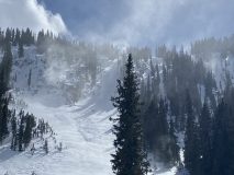
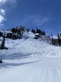
Avalanches: Intentionally trigged several D1 loose avalanches on south-facing near treeline slopes – ran on 4-7cm knife hard melt/freeze crust.
Remotely triggered a slab on an east aspect at 11,200′ from low-angle terrain above – never got vis below the convex roll so uncertain if it propagated further as it ran downhill.
Weather: Overcast skies, moderate northwesterly winds, generally S1 snowfall from 11am – 4pm. Hard to say how much it snowed while out as the storm snow was settling as it accumulated.
Snowpack: Midday measured around 12″ new snow w/ .9″SWE at 10,600′. Observed a midstorm density change in Shovel Tilt Tests. Stomped around on several small shaded test slopes and several steep sunny slopes with almost no cracking other than some ski length cracks in shallow drifts on leeward southerly features. While walking above a steep east-facing slope, looking for a facet/crust combination underneath the new snow, I was able to remotely trigger a convex roll below me. I was not able to get to the crown and never got a good view of the terrain below, but probing above the crown confirmed a soft, collapsible crust beneath the storm snow (similar to obs from Axtel and Snodgrass earlier in the week). I suspect due to wind, I missed the audible collapse of the crust as I skied above. The crown appeared to be slightly drifted where it failed. Snow felt noticeably thicker throughout the day as it settled.

Second-hand reports from Axtel stated 8″ new snow with some loose snow sluffing, and one small triggered slab in an open area below treeline.


Photos:

Orographics return

CBAC2020-21 Observations

Date of Observation: 03/14/2021
Name: Zach Kinler
Zone: Northwest Mountains
Aspect: North, North East
Elevation: 10,000-11,200

Avalanches: Triggered 2 small slabs both running within the new snow on drifted features near and below tree line. Crowns averaged 6-10″.

Weather: Overcast, S1-S2 snow showers with 2′ accumulation during the day. Cold with moderate NW winds in large open areas below tree line and all near tree line locations.

Snowpack: HST 14″ at 3:30 pm.  Measured 12″ with .8″ SWE at 10:00. Overnight snowfall was low density at around 6%. Density increased slightly through the day but remained quite enjoyable. Minor cracking was observed only in spots where winds were able to drift snow. Cracking and small slabs were breaking within the new snow in this location. Open slopes near tree line in this terrain were getting cross-loaded by moderate WNW winds throughout the day.


Gothic 7am weather update

CBAC2020-21 Observations

Date of Observation: 03/14/2021
Name: Billy Barr


Zone: Southeast Mountains
Location: Gothic Townsite

Weather: Keep moving, nothing to see here. Saturday was windy with just very light snow. Last night no wind but with only light snow so the 23 hour (lose one for DST) total is 2½” new snow with 0.21″ of water while the snowpack is at 44½” deep. Wind started back up this morning just before 6 a.m. so it is currently cloudy and windy but no snow falling. Yesterday’s high was 36F, low 15 and currently 18 while wind is 4-10 W. billy


Snodgrass

CBAC2020-21 Observations

Date of Observation: 03/13/2021
Name: Eric Murrow Jared Berman


Zone: Southeast Mountains
Location: Snodgrass north side
Aspect: North, North East, East
Elevation: 9,500 – 11,100′


Avalanches: no recent avalanches observed
Weather: Clear skies in the morning, with gusty southeasterly winds, gave way to cloudy skies just before noon. Wind reduced significantly once the snowfall began. Intermittent light snowfall from noon until 4 then an increase in snowfall rate of S1 to S2 from 4 to 530. Total new snow as of 530 was 1.5″ at 9,500′.
Snowpack: Targeted some north and easterly slopes looking at surfaces that the incoming storm will fall on. On east slopes below treeline a double crust with facets between was observed like in other parts of the range. This double crust setup will likely help spread failures further across a slope once loaded by incoming/current storm (see photo).
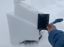
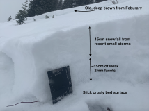
Moving onto northeast-facing slopes with depths around 130cm we tested deeper weak layers in the snowpack, 12/10 and 1/19, with ECTX results and 45/110 END, 35/100 END PST scores respectively. Near the surface on shaded slopes, about 15 – 20cm down, is a layer of 1mm facets that looks to be a likely failure plane for the incoming storm (see photo). This layer popped cleanly in shovel tilt tests with moderate force. I expect if/when avalanches occur during this loading event on shaded slopes below treeline that this is where avalanches will break first.
Lastly, we traveled through an avalanche path that ran on the basal Depth Hoar layer in February and found around 20 – 40cm of refill. Resting immediately above the slick bed surface was a layer of well-developed facets (see photo). I anticipate many shaded below treeline paths that avalanched in February will not require a significant load before failing again.


Photos:

Weird wind loading on 3/12

CB Avalanche Center2020-21 Observations

Date of Observation: 03/12/2021
Name: Sam Eller


Zone: Northwest Mountains
Location: The Playground and Ohio Pass
Aspect: North, South, South West
Elevation: 10,000


Avalanches: Knocked off a small wind slab that had loaded low into one of the chutes in the playground. Observed a large wet slab that appeared to be only a few days old.
Weather: Warm but strong south winds were keeping slopes from wetting extensively. Winds were blowing up the basin and loading in the north chutes from the bottom as well as other aspects.
Snowpack: Dug several handpits on the the way up north facing where there was a small facet layer 30cm down under the new March snow. South facing was wetting in the new snow but crust underneath was supportive all day. Wind affect on most aspects after midday.


Photos: