A Canary in the Elk Mountains?

CB Avalanche CenterAvi-Off-Season


Canaries were once used in coal mining as an early warning system for toxic gases leaking into the mine.  Signs of distress, or worse, a dead bird, would caution the miners that it was time to retreat from the mine.
Last week, a warm airmass brought our first real taste of spring to the Elk Mountains.  Nothing out of the ordinary as far as Crested Butte weather goes, but enough that pale white skin made its spring debut on Elk Street before hastily retreating to aloe vera treatments.  On Sunday and Monday (March 9 and 10), temperatures rose to just above freezing at 12,000 feet under an intense March sun.   Days later, following a few inches of snow and cooler temperatures, we observed the results of some very unnerving deep slab avalanches.  Sometime after Monday evening, a huge slab tore off of the south face of Mt. Owen.  This appeared to be triggered by a cornice falling onto a shallow part of the slope, but it propagated to parts of the slab that were 12 feet deep.   
Deep slab on Mt. Owen, first spotted 3/12/14

Looking down the crown
On Wednesday night, another monster ripped off of a southwest facing ridge near Avery Peak.  This one raised the hairs on the back of my neck.  Two deep slabs back to back, under relatively mild and stagnant weather.  The Avery slide did not appear to be cornice-fall triggered, and has raised a lot of questions and spurred a lot of speculation on the failure mechanics among local and statewide avalanche professionals.  Although meltwater on high elevation terrain has been pretty minimal to this point, it seems plausible that a hot spot on the slope, such as a sunbaked rock or simply an oven-like part of the slope, could have channeled heat and meltwater into a shallow part of the snowpack.  Once meltwater percolates to a buried weak layer, it can compromise the layer’s strength causing a wide and destructive failure. The timing of these events can be unpredictable.  Maybe warming had subtle effects on the slab properties that added up just enough on this slope.  We’re still not sure.
 

And another.  This one near Avery Peak.

With just a tease of spring under our belt and much more warm and sunny weather inevitably to come, this begs the question:  Are we seeing the tip of the iceberg right now?  Did the canary just faceplant into the bottom of the cage?  Warming and meltwater will continue progressing into the snowpack, first on southerly slopes, and eventually around the compass to north.  We know weak layers are at the bottom of the snowpack lurking and they are proving to be reactive.  Cornice falls will become more frequent as these overhanging blocks of snow continue to thaw and sag from their own massive amounts of weight.   We are not out of the woods yet when it comes to deep slab problems.  These last two slides should serve as a healthy reminder to use an extra dose of caution this spring in your backcountry travels. Be diligent in your terrain selection and in the attention you give to weather, snowpack, and avalanche patterns in the upcoming months.

Zach Guy
CBAC Forecaster

Recapping a historic avalanche cycle

CB Avalanche CenterAvi-Off-Season

Zach Guy
CBAC Forecaster

The first two weeks of February were exciting (but sleepless) times to be an avalanche forecaster.  An unusually large storm was accompanied by unusual avalanches.  Around the central and northern mountains of Colorado, avalanches destroyed or buried buildings, closed roads, and extended trim lines of previous historic paths.  Sadly, four fatalities occurred as well.  

I put together a simplified summary of the storm and a timeline of natural avalanche activity, highlighting some of the largest and/or most unusual avalanches that occurred around our Crested Butte backcountry and surrounding roads.  I’m certain this is only a small percentage of the natural avalanches; our zone is too vast to get the full picture from our lookout points and observations.  I ordered and dated these avalanches according to the first date that they were observed or reported to us, but the exact failure dates are open for speculation.
The storm began January 30th, with a quick and massive hit of roughly 4.0” of SWE in the favored zones and 2.0” of SWE near town in just 60 hours.  Natural avalanches were widespread, but confined to the new snow, and most common at low elevations where the surface snow was weakest.  We were a bit surprised not to see any deeper slides in the alpine when the clouds cleared for a day on February 2nd.  Maybe our snowpack was tougher than we thought??
Anthracite Range. Observed February 2nd.  

Snowfall picked up again on February 3rd: fluffy snow, modest accumulations, with moderate winds, and a lull in avalanche activity.  On the night of February 7th, the Pacific river of moisture found a direct path to Crested Butte.  Wind assisted snow transport had been steady and relentless for several days, and Gothic was the first to shed in a big way.  The NE face ran full track, crossed the East River, and ran uphill burying (and perhaps destroying?) a newly installed outhouse structure in the Judd Falls parking area.  Oh crap! Several observers called this one a D4, about as big as they get in Colorado.  
Gothic Mountain runout.  The pipe is to the top of the outhouse structure that was buried 10-20 feet deep. Observed February 8th. 
The river of moisture was relentless until February 10th, and the favored mountains picked up another whopping 3.5” of SWE while Mt. CB got 2.5” over the 4-day period.  Schofield Pass hit 9.5″ of SWE over the storm period.  Winds continued at moderate speeds, with the usual stronger gusts.  We had no visibility and limited avalanche observations during this time.  Then the clouds lifted on February 10th and 11th, and revealed a warzone.  Almost everything steep near town had slid, from small road cuts, to river banks, to more sizeable paths.  Almost all of Snodgrass had slid, breaking trees and covering Gothic Road in feet upon feet of debris.  Debris ran across Peanut Lake Road and onto the nordic tracks.  Unusual crowns were all over the mountains closer to CB South.  Deep slabs pulled out of the Ruby Range.  Slides that hadn’t run in 20 years crossed Cement Creek Road. At least 5 paths crossed Taylor Canyon Road, and several structures near Almont and in Taylor Canyon were impacted.  At least 4 paths crossed Spring Creek Road (not sure on the timing of these last few slides…could have been a few days later).
This slide crossed Peanut Lake Road around 8:30 a.m. February 10th.  
An estimated 2/3 of Snodgrass Mountain slid to near the ground.  Observed February 10th.
Unusual crowns on Double Top Mountain. Observed February 10th
Large slides above town from Gibson Ridge.  Observed February 10th.

Crown lines running across the entire width of Cement Mountain.  Observed February 10th.
Slides near Meridian Lake.  Observed February 11th.
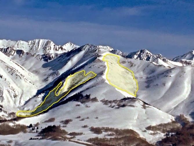
Peeler Basin. Estimated half mile wide. Observed Februay 11th. 
Deep slab on Purple Mountain, estimated up to 20+ ft deep. Observed February 11th.  
Deep slab on Afley.  Observed February 11th.

Small doses of snow fell and wind speeds increased on February 12th through the 15th.  Temperatures started to climb, eventually hitting the high 40’s in Crested Butte. We even saw short bouts of rain at all elevations.  The natural cycle was far from over.  Another natural came down to Cement Creek Road.    A few more huge ones ripped off of the peaks. 

Near White Mountain; this path ran similar to the notorious skier triggered slide from 2008.  Observed February 14th.
Several historic slides crossed Spring Creek Road.  Observed February 14th.
Slides across Cement Creek.  Observed February 14th and 15th.
Slides impacted structures in Taylor Canyon and near Almont. Observed February 15th.
Slab failing near the ground on Whetstone.  Observed February 16th.
Another D4 off of Peeler Mountain.  Observed February 17th.
Near WSC Peak.  Observed February 17th

This memorable cycle was spooky, challenging, exciting, and stressful all at once.  I wish I had a helicopter to fly around the range now to get a full view of the impacts of this cycle.   
Thank you to everyone for submitting observations the past few weeks.  A special thanks to Ben Pritchett, Ian Havlick, Pete Sowar, Briant Wiles, Andrew Breibart, Jayson Simons-Jones, and Gary Dotzler for their photos. 

Digging out the details of this storm. How big was it?

CB Avalanche CenterAvi-Off-Season

Zach Guy
CBAC Forecaster
Natural deep slab off of Afley Peak

Since January 29th, the mountains around Crested Butte have been walloped by heavy snowfall.  On February 10th, the storm finally cleared.  My back is nearly broken from endless shoveling, my roof has avalanched at least twice, and I’ve heard lots of folks saying this is the biggest storm they’ve ever seen.  How historic was this storm?
The Schofield Pass SNOTEL site is a remote weather station north of Gothic Townsite that measures snow depth and snow water equivalent at hourly intervals.  Snow water equivalent (SWE) is the amount of water that would melt out of the snow falling from the sky.  An inch of rain measures as an inch of SWE, and a foot of snow typically produces about an inch of SWE.  Between January 29th and February 10th, Schofield Pass received 9.5” of SWE. That’s easily 10 feet of snow!  Since Schofield’s weather station was installed in 1985, four major storms stand out, with a return interval of roughly 6 years:  February 1986 (13.5” SWE), February 1995 (9.7” SWE), January 2005 (8.0” SWE), and December 2010 (9.4” SWE).  All of these storms came in unusually warm, with abundant moisture streaming from the Pacific.  Three out of four of these storms resulted in Extreme avalanche danger, with widespread and long-running avalanches into valley bottoms.  

This storm, with 9.5” SWE, is comparable in precipitation levels to these previous historic storms, but it fell over nearly twice the time span.  At the avalanche center, we compared our current storm to previous storm patterns to help decide whether to upgrade the danger to extreme.  Extreme danger means very large and destructive avalanches are widespread; the type of danger where we might expect Red Lady Bowl to come across Kebler Pass Road.  It’s a very challenging forecast when the mountains are socked in clouds and we have very few observations to work off of.  During this storm, we rated the avalanche danger as high during 5 days of the storm.  After the clouds cleared, we observed widespread avalanches and a dozen or more very destructive avalanches.  One ran off of Gothic Mountain, crossed the East River, and buried a structure 20 feet deep! Did we hit extreme danger?  I’m not sure..we were dang close.  There are two reasons we didn’t bump the danger to extreme on February 10th:  The storm reached its maximum precipitation rate early in the storm rather than late, and it happened over a span of 13 days, while the other historic storms came in over 6 or 7 day periods.   All in all, it was a memorable storm and ranks as one of the larger storms we’ve seen in the past 30 years.  Whether it was at the ski resort, in the backcountry, or driving your car to work, I hope you found some of that fluffy white stuff flying in your face!

Thanks to Art Mears and Ben Pritchett for their contributions to this article.

Large natural avalanches off of Snodgrass Mountain snapped trees and crossed Gothic Road


What is surface hoar?

CB Avalanche CenterAvi-Off-Season

You may have heard us warning backcountry skiers and riders about buried surface hoar in our avalanche advisories this month.  So what is this lurking predator and how do we know where to find it? 
                Surface hoar, sometimes called “hoar frost”, is that beautiful, glimmering, feathery crystal you’ve probably admired while strolling around town.  When it gets buried on a steep slope, it can be an incredibly fragile and dangerous weak layer that can persist for weeks or months.  Surface hoar is the winter version of dew.  In order for it to form, we need 3 ingredients:  clear nighttime skies without canopy cover, calm winds, and some relative humidity in the air.  Of course, these feathery crystals aren’t a problem unless they are preserved below a slab of snow.  In Crested Butte, we frequently see strong winds prior to the arrival of the next storm, which helps destroy those fragile layers.  Sun-baked slopes can also cook the layer into submission.  The take-home point here is that there are a lot of factors at play that can make for variable and spotty distribution of buried surface hoar; some slopes may have it while others don’t.

                We had a significant surface hoar event around Thanksgiving that was buried on some slopes after our early December storms.  We’ve been finding it preserved on shaded and wind protected or leeward slopes, especially at lower elevations.  It has been the culprit for a handful of avalanches these past few weeks.  This layer has been fairly easy to identify in a snow pit: it looks like a thin grey stripe in the snow (this is not always the case). 

The obvious grey stripe in the middle of the pit is a layer of buried surface hoar found on Schuykill Ridge this week.

We are just exiting another high pressure weather pattern that is favorable for surface hoar growth.  When you’re out touring in avalanche terrain, look for surface hoar and what slopes it is forming on to give you a better idea of places to avoid if it gets buried and becomes problematic.  And don’t forget check our website for the most up-to-date avalanche conditions before you head out.  www.cbavalanchecenter.org

-Zach Guy

No Niño??

CB Avalanche CenterAvi-Off-Season

For the past several years, much of the early season buzz about whether we were going to have a killer winter or a dud revolved (over. and over. and over…) about the pros and cons of an El Niño or La Niña   atmospheric and oceanic signal.  

Here is a post from one of my former meteorology professors at the University of Utah and total powder junkie himself, Jim Steenburgh.  He runs a great weather blog that discusses meteorology mostly around Utah, but a ton of his material is applicable to our locale as well.  Bookmark it and check it out! Infer what you can about how the lack of ENSO will affect our weather patterns…the overarching theme being….your guess is as good as mine.  A good perspective if nothing else.

http://wasatchweatherweenies.blogspot.com/2013/08/outlook-for-20132014-ski-season.html

My take is that the Arctic Oscillation is just as big of a contributing factor that is often over looked. “The positive phase of the Arctic Oscillation brings ocean storms farther north, making the weather wetter in Alaska, Scotland, and Scandinavia and drier in the western United States and the Mediterranean. In the negative phase of the Arctic Oscillation the patterns are reversed. A strongly negative phase of the Arctic Oscillation brings warm weather to high latitudes, and cold, stormy weather to the more temperate regions where people live. Over most of the past century, the Arctic Oscillation alternated between its positive and negative phase. For a period during the 1970s to mid-1990s, the Arctic Oscillation tended to stay in its positive phase. However, since then it has again alternated between positive and negative, with a record negative phase in the winter of 2009-2010″(National Snow and Ice Data Center).

What tilt are we in now you may ask??
These are very interesting (and confusing) but if you look at each graph, you have a neutral AO signal at zero, with the blue bars going up meaning positive, going down, negative. Makes you think a little what phase we have been in for extreme weather, like our early season snows, the Front Range floods in September, etc.
More info here:

I will probably steer some of my posts of this forecaster’s blog to Jim’s blog occasionally.  Enjoy this snowy Sunday…so far I like No Niño…

-Ian Havlick

TED Talk on Avalanche Hazard and Risk

CB Avalanche CenterAvi-Off-Season

Grant Statham gave a great TED talk recently on risk in avalanche terrain that has been circulating around the avalanche community lately.  Grant has spent a lifetime climbing, skiing and guiding in extreme terrain around the world and he has spent the past 10 years or so working as a risk management specialist for Parks Canada.  Grant does a great job of explaining risk and hazard and how it relates to travel in avalanche terrain in this TED talk.

See Grant’s 12 minute talk by clicking HERE or on Grant’s photo below.


Grant Statham from Parks Canada

The components of avalanche risk from Bruce Tremper’s (Utah Avalanche Center Director) new book Avalanche Essentials, which illustrate the points Grant makes in his talk.

-Ian Havlick
CBAC Forecaster