Mountain Weather for 11,000ft. Friday 4/3

CB Avalanche CenterWeather

Date: 04/03/2020

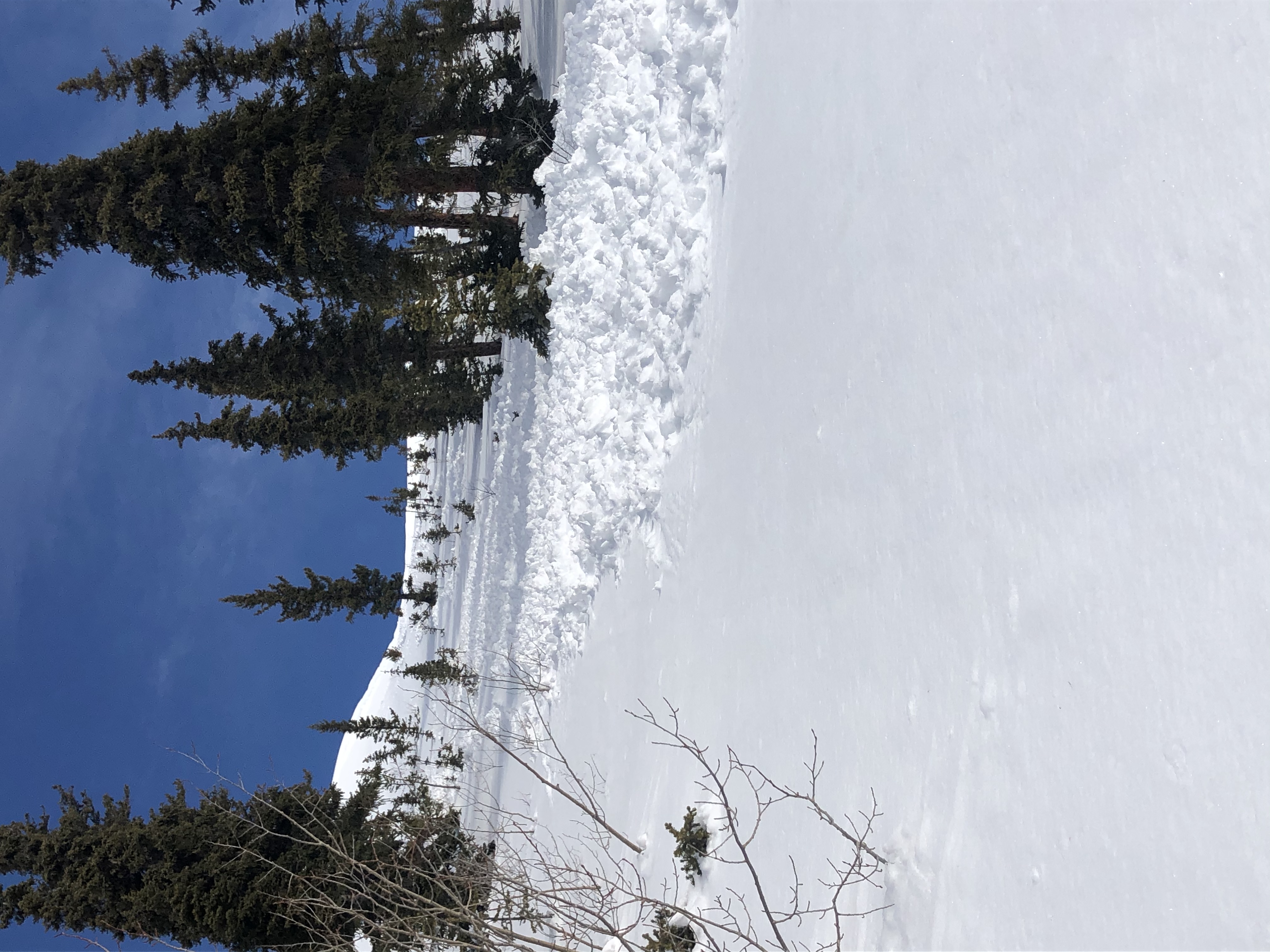
Say hello to dry westerly flow. Friday sure is looking like a nice day. Temperatures plummeted overnight with the arrival of cold air. Valley elevations may be the only areas to get above freezing today, so expect slightly colder temperatures than the last several days, but we also have the strong April Sun. We can still see some periods of stronger winds today, but otherwise, those winds have been on a decrease overnight and that trend will continue into today.

Moisture starts to move in late on Friday and there is a chance for a couple of flakes to fall on Saturday morning. Looks like we’ll have a few more clouds on Saturday as we wait for the moisture to get pushed out, and high temperatures will rise another 5 to 8 degrees.

Nothing too exciting in the weather until maybe mid next week.

  • Today

    High Temperature: 29 to 33
    Winds/Direction: 10 to 20/WSW
    Sky Cover: Mostly Clear
    Irwin Snow: 0
    Elkton Snow: 0
    Friend’s Hut Snow: 0

  • Tonight

    Low Temperature: 18 to 22
    Winds/Direction: 5 to 15/SW
    Sky Cover: Mostly Cloudy
    Irwin Snow: 0 to 1
    Elkton Snow: 0 to 1
    Friend’s Hut Snow: 0 to 1

  • Tomorrow

    High Temperature: 36 to 40
    Winds/Direction: 7 to 17/WSW
    Sky Cover: Partly Cloudy
    Irwin Snow: 0
    Elkton Snow: 0
    Friend’s Hut Snow: 0

S Carbon Spoon Natural Wet Slide

CB Avalanche Center2019-20 Observations

Location: Kebler Pass Area
Date of Observation: 04/01/2020
Name: Turner Petersen
Subject: S Carbon Spoon Natural Wet Slide
Aspect: South East
Elevation: 11,000

Avalanches: Natural wet slides from previous day. Ran aprox. 300ft from cornice down through trees.

Snowpack: Full freeze thaw crust on E—SW. upper northerlies still dry and cold.

East side shaded snowpack obs

CB Avalanche Center2019-20 Observations

Location: Cement Creek Area
Date of Observation: 04/01/2020
Name: Eric Murrow & Zach Kinler
Subject: East side shaded snowpack obs
Aspect: North, North East, East, South East, South, South West, West, North West
Elevation: 8,900′ – 12,250′

Avalanches: Observed a handful of recent (past couple days) Wet Loose avalanches on southerly and east aspects near treeline. Most came from rocky areas or locations immediately below cornices. The largest one came from a south aspect on flanks of WSC Peak, D1.5-D2ish in size. Most other Wet Loose avalanches were very small. Far less Wet Loose activity in Cement and Brush Creek drainages than Kebler Pass and Paradise Divide areas.

Lots of small to moderate recent cornice falls on east through south aspects without result.

Very little evidence of significant avalanche activity from the past week. Visibility was ok, but light was flat so possibly could have missed evidence viewing much of the terrain at a significant distance. The natural avalanche reported from the east bowl of Cement Mountain on 3/29 was the most significant avalanche observed.

Weather: Partly cloudy skies to start the day with increasing cloud cover. Winds from the southwest were constant near and above treeline. Speeds never pushed much above 20mph.  Some snow continues to be transported to easterly alpine features.

Snowpack: Made targeted obs on shaded slopes near treeline looking at Persistent Slab structure. The upper 35cm of the snowpack had two interfaces of interest that presumably formed during the past few weeks. In the shallower, minimally drifted, sites we dug at produced ECTN results. The lower of these two interfaces is a soft melt/freeze crust with a thin layer of facets above the crust much like other parts of the range. The faceted grains were about 1 – 1.5mm in size and showed signs of rounding. The middle and lower snowpack has gained a substantial amount of strength over the past month. The oldest Depth Hoar near the ground was 1finger hard with substantial rounding. The one interface of interest in the lower snowpack did not produce any results in CT or ECT even when hammering until my hand hurt, but would pop when the column was pried with a shovel. See photo

Photos:

Ruby Range

CB Avalanche Center2019-20 Observations

Location: Kebler Pass Area
Date of Observation: 04/01/2020
Name: Evan Ross
Subject: Ruby Range
Aspect: North East, East, West, North West
Elevation: 9,500-13,000

Avalanches: Unintentionally skier triggered one small Wind Slab. NW, 12,000ft. Mostly noticed small loose wet avalanche activity from yesterday on East-South-West. Another large cornice fall off East Beckwith. That cornice didn’t appear to trigger a slab below, but the debris were still large in size. Hard to tell how fresh it was.

Weather: Moderate winds, with some stronger gusts. Snow available for transport is running low. Partly cloudy sky in the morning became mostly cloudy in the afternoon.

Snowpack: Same same for conditions. Managing a couple small avalanche problems. Those small avalanche problems are enough to push you into more hazards terrain given the types of terrain we ski this time of year. Mostly loose wet and old wind slabs. The largest avalanche problems were dealing with cornice hazards from above or below.

Mountain Weather For 11,000FT. Wednesday 4/1.

CB Avalanche CenterWeather

Date: 04/01/2020

Wednesday will be a transitional day ahead of an approaching low-pressure system out of the Northwest. Cloud cover will increase some today ahead of the approaching system with warm temperatures and moderate, yet gusty winds, from the southwest. Cloud cover continues to increase on Wednesday night providing a blanket to insulate against radiational cooling. A stray shower is possible overnight.

The incoming storm system looks to impact the area around midday on Thursday as an associated cold front reaches the Crested Butte area. Moderate snowfall will likely accompany the cold front, but this pulse of snowfall will likely be short-lived. Light snow will linger through Thursday night and taper off through Friday morning. Expect air temperatures on Thursday night and Friday morning to be well below seasonal norms as the area will be under a cold northwest flow. Snowfall totals are looking rather meager by the time the system moves eastward.

  • Today

    High Temperature: 42 to 46
    Winds/Direction: 10 to 20/WSW
    Sky Cover: Partly Cloudy
    Irwin Snow: 0″
    Elkton Snow: 0″
    Friend’s Hut Snow: 0″

  • Tonight

    Low Temperature: 26 to 30
    Winds/Direction: 12 to 22/SW
    Sky Cover: Mostly Cloudy
    Irwin Snow: 0 to trace
    Elkton Snow: 0 to trace
    Friend’s Hut Snow: 0 to trace

  • Tomorrow

    High Temperature: 37 to 41
    Winds/Direction: 16 to 26/WSW
    Sky Cover: Mostly Cloudy
    Irwin Snow: 2 to 4″
    Elkton Snow: 2 to 4″
    Friend’s Hut Snow: 2 to 4″

Paradise Divide Look Around

CB Avalanche Center2019-20 Observations

Location: Paradise Divide Area
Date of Observation: 03/31/2020
Name: Evan Ross
Subject: Paradise Divide Look Around
Elevation: 9,500-13,000

Avalanches: Passed through a bunch of terrain, so you’re going to see a bit of everything. Multiple cornices released today. The ones I saw entrained some surface snow or shallow slabs, but I didn’t see anything reach D2 in size. Natural Loose Wet Avalanches at all elevations. In the Alpine, easterly seemed to have the most wet activity as they were the most protected from the wind. At least one loose wet reached D2, but most of everything I saw was in the D1 to D1.5 range. Several small surface slabs out there. Old slab  avalanches that had released deeply into the snowpack were either, non existent, out of sight, or I didn’t see them. I did see a D2 on a SE cross-loaded feature of Mineral Point. That one looked like a shallow Wind Slab.

Snowpack: Lots of snow surfaces were becoming moist or wet out there. Definitely a big transition day for many slopes. Mostly found myself managing cornice hazards or wet issues. Otherwise no other signs to instability.

Wet snow, cornice falls, and stability tests

CB Avalanche Center2019-20 Observations

Location: Paradise Divide Area
Date of Observation: 03/31/2020
Name: Eric Murrow
Subject: Wet snow, cornice falls, and stability tests
Aspect: North East, East, South East, South, South West, West
Elevation: 9600′ – 12000′

Avalanches: Lots of loose snow avalanches on east through south slopes at most elevation bands often from rocky areas. Loose snow avalanches observed remained D1.5 or less. One cross-loaded southerly feature on Mineral Point produced a D2 slab. Viewed several recent cornice-falls that failed to trigger large slab avalanches, looked to just entrain surface snow.

Weather: Mostly clear skies with warm air temperatures. Westerly winds near and above treeline were brisk and continuous. Observed modest amounts of snow transport onto northeast, east, and southeast slopes but loading was fairly light as lots of snow was being blown into the atmosphere or lower on to slopes.

Snowpack: Dug a test profile on a north-northeast facing slope at 11,600′ checking on the mid-March interface. No result in ECT at the mid-March interface (hammering until my hand hurt got it to propagate). Careful grain ID showed rounding of the thin facet layer (no crust was present at 3/18 interface at this location).

On south-facing slopes below treeline in the afternoon I found an HS 130 cm at 10,600 feet. This site had a few inches of wet surface snow with a soft crust below and dense moist snow below that resting on a very thick melt form layer. Wet concerns on this terrain remained near the surface with little chance of gouging. Closer to the trailhead at 9,600′ I found a shallow, wet snowpack that appeared capable of producing wet loose avalanches that could entrain much of the shallow snowpack. See photos.

West aspects near treeline became moist even with the wind, but did not produce loose avalanches.

Photos:

Mountain Weather For 11,000FT. Tuesday 3/31.

CB Avalanche CenterWeather

Date: 03/31/2020

The low-pressure trough that brought the latest round of snowfall has moved eastward and the area currently sits under a zonal, westerly, flow with mostly dry conditions. Cloud cover decreased overnight and should last through Tuesday night. Winds are forecasted to remain elevated on Tuesday and continue to drift snow at upper elevations. Air temperatures will rise a few degrees above seasonal norms on Tuesday and Wednesday. No precipitation is expected during the next two days, but some thin, high-level cloud cover could sag down from the north bringing a slight increase in cloud cover on Wednesday.

A low-pressure system in the Pacific Northwest will slowly slide to the southeast over the next couple of days. The next chance for accumulating snowfall will come on Thursday and Friday as the system from the northwest, along with it’s accompanying cold front, reach Colorado. It is a little early for snowfall numbers, but this system does not look impressive but should provide a refresh to surface conditions.

  • Today

    High Temperature: 38 to 42
    Winds/Direction: 10 to 20/W
    Sky Cover: Mostly Clear
    Irwin Snow: 0″
    Elkton Snow: 0″
    Friend’s Hut Snow: 0″

  • Tonight

    Low Temperature: 23 to 27
    Winds/Direction: 7 to 17/WSW
    Sky Cover: Mostly Clear
    Irwin Snow: 0″
    Elkton Snow: 0″
    Friend’s Hut Snow: 0″

  • Tomorrow

    High Temperature: 40 to 44
    Winds/Direction: 10 to 20/WSW
    Sky Cover: Partly Cloudy
    Irwin Snow: 0″
    Elkton Snow: 0″
    Friend’s Hut Snow: 0″

Baxter Basin

CB Avalanche Center2019-20 Observations

Location: Paradise Divide Area
Date of Observation: 03/30/2020
Name: Zach Kinler
Subject: Baxter Basin
Aspect: North, North East, East, South East, South
Elevation: 9,600-11,100
Avalanches:

2 x Wet Loose D1 East 10,000′
1 x Wet Loose D1.5 Skier-triggered SSE 11,000′

Weather: B-A-N-A-N-A-S, this weather is bananas!. Saw it all today with nothing consistent for more than half an hour at a time. Light to moderate snow showers, graupel showers, intense sunshine, a bit of green-housing after periods of sun when the wind wasn’t present, wind drifting small amounts of snow and an occasional winter-like feel when clouds snow and wind combined forces.

Snowpack: 5″ HST which settled quickly and became moist on all aspects below ~9800′. Due north stayed dry above that elevation. A few small wet loose avalanches including one skier-triggered were able to run on the previous day’s crust, which was smooth and slick.