Below Tree line Wet Stuff

CB Avalanche Center2019-20 Observations

Location: Crested Butte Area
Date of Observation: 04/06/2020
Name: Zach Kinler
Aspect: North, North East, East, South, South West, West
Elevation: 9,800-11,000′
Avalanches:

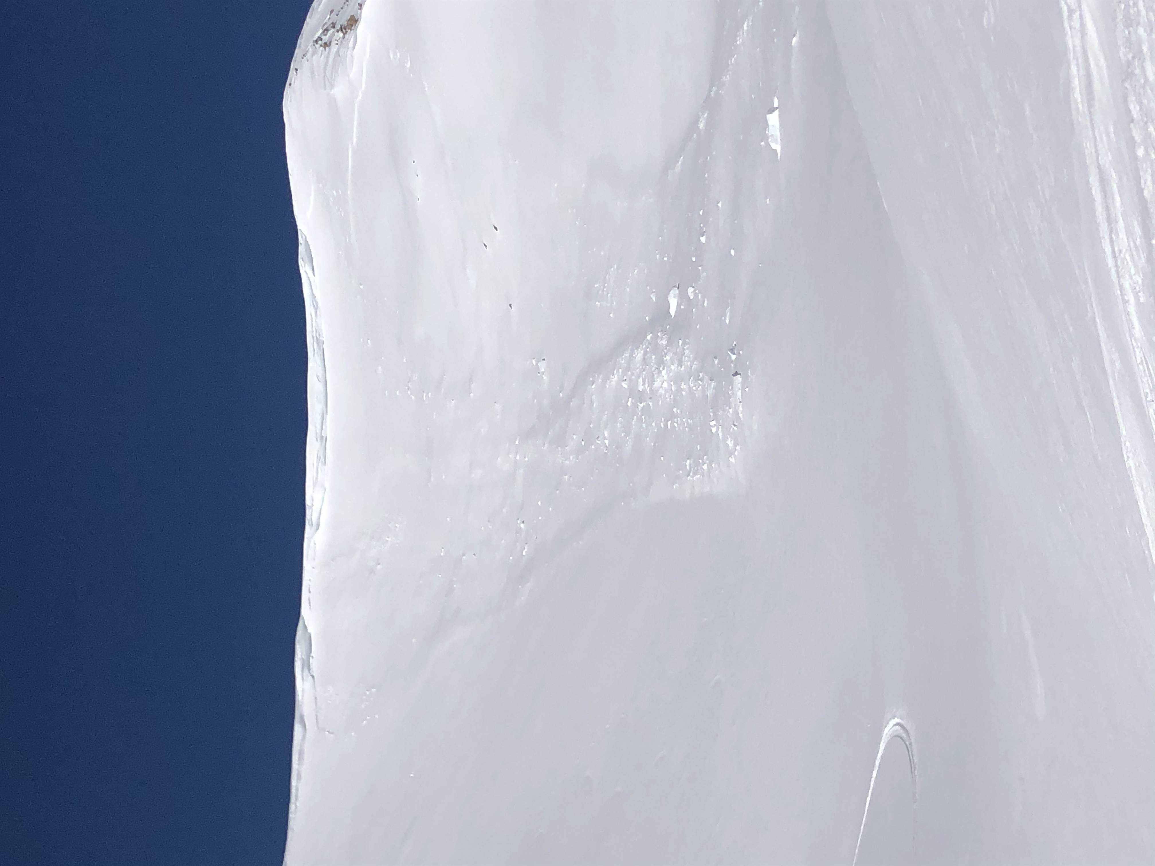
Several Wet Loose on steep southerlies near treeline on Red Rock Ridge.
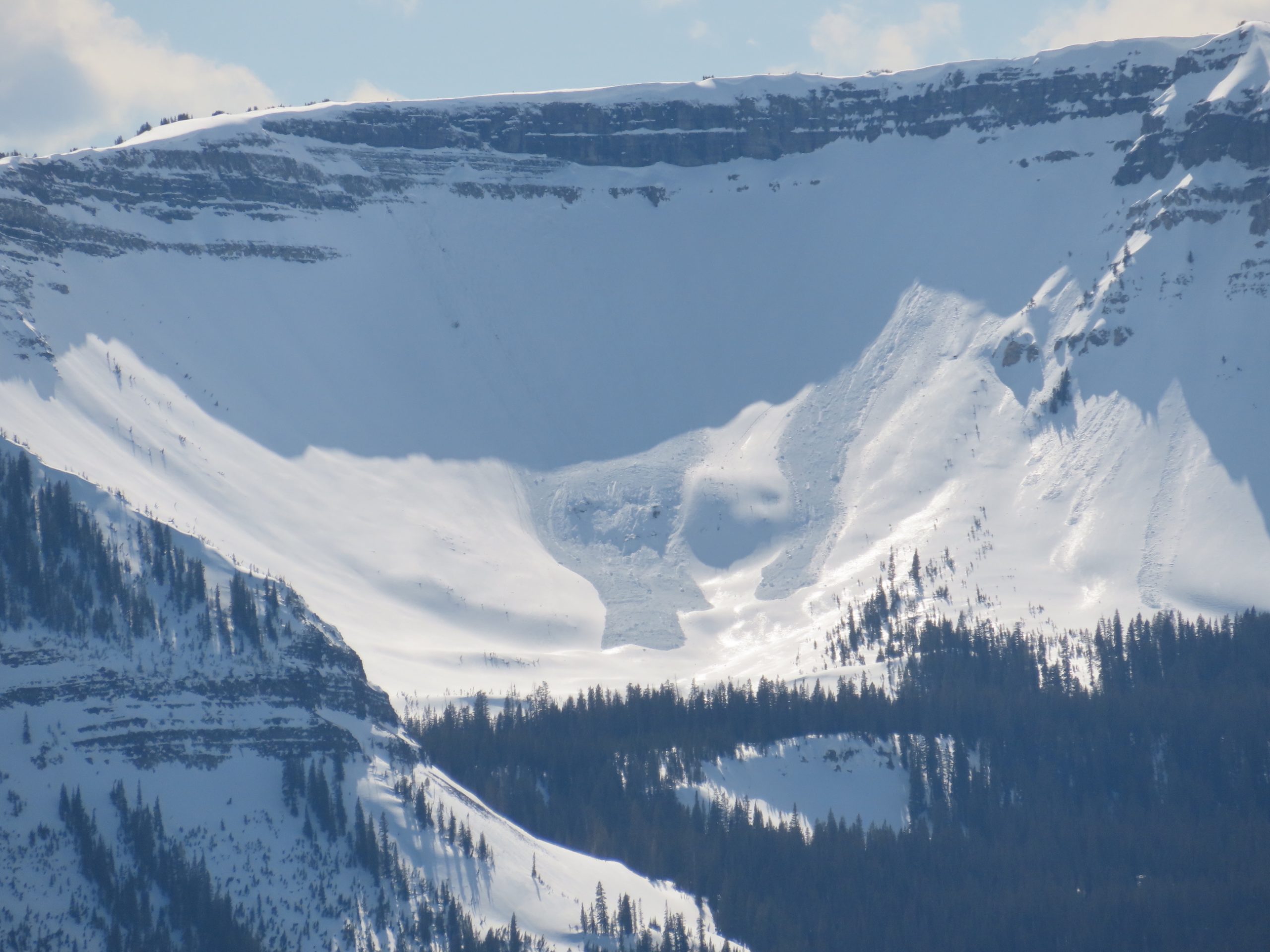
D2 Cornice triggered slab avalanche off Scarp Ridge above Peeler Basin
D1.5 Cornice triggered slab avalanche immediately adjacent to above avalanche.

Weather: Beautiful day with lots of sun. Temps were well above freezing. SW winds felt nice in open areas while sheltered slopes felt the warmest of the year.

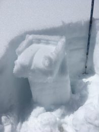
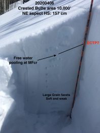
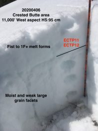
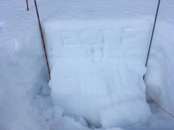
Snowpack: Began the tour on E aspects around 12:00 with lots of collapsing and cracking around skis. Quick upper snowpack pit at 9,800′ revealed CT13 SC results beneath a moist crust around 25 cm deep. Moving to a NE aspect at 10,000, free water had made it to a crust/facet combo around 30cm deep with ECTP7 results. On a N aspect at 10,000′ no free water was present but easy hand shears revealed 1 mm facets around 35 cm deep. Lower elevations may be seeing water at this interface if not soon. Moving around S towards W aspects in the afternoon and a similar structure as the E aspect was encountered with moist yet somewhat supportive melt forms forming a slab-like structure over very weak and moist facets below. Cracking and collapsing of up to 30′ was observed on slopes up to 30 degrees as well as ECTP11 and ECTP12 results on W aspect at 11K. Several inches of wet surface snow was present E-S-W aspects with Wet Loose avalanches possible on slopes greater than 35 degrees. Overall structure in this zone at these elevations was poor with slabs over very large and weak grains.

Mountain Weather for 11,000ft. Monday 4/6

CB Avalanche CenterWeather

Date: 04/06/2020

A broad mid-level low-pressure system continues to slowly work its way south off the coast of California. This will keep our area in warm but dry SW flow. Breezy conditions with ample sunshine will prevail for the next few days as this cut-off system shows little eastward progression until getting picked up by the sub-tropical jet midday Wednesday. High temperatures today will top out a few degrees warmer than yesterday with very similar conditions for tomorrow.

Uncertainties remain regarding timing and track of this low as it moves across the Great Basin and towards Colorado by late Wednesday however a return to unsettled weather looks likely heading towards the end of the week.

  • Today

    High Temperature: 42 to 46
    Winds/Direction: 10 to 20/SW G30
    Sky Cover: Mostly Clear
    Irwin Snow: 0
    Elkton Snow: 0
    Friend’s Hut Snow: 0

  • Tonight

    Low Temperature: 23 to 27
    Winds/Direction: 8 to 18/SW
    Sky Cover: Mostly Clear
    Irwin Snow: 0
    Elkton Snow: 0
    Friend’s Hut Snow: 0

  • Tomorrow

    High Temperature: 42 to 46
    Winds/Direction: 10 to 20/SW
    Sky Cover: Clear
    Irwin Snow: 0
    Elkton Snow: 0
    Friend’s Hut Snow: 0

Springtime Weather Roller-Coaster

CB Avalanche Center2019-20 Observations

Location: Kebler Pass Area
Date of Observation: 04/05/2020
Name: Eric Murrow and Zach Kinler
Aspect: North, North East, East, South East, South
Elevation: 9,000′-12,000′

Avalanches:
Gibson Ridge ENE 9,700 D1.5 Wet Loose gouging to ground in shallow snowpack
Ohio Peak ENE 12,000′ D2 Cornice fall triggered smaller slab below the ridgeline pulling out another small but deeper slab around cliffs.
Axtel ENE 11,800 D1 Wet Loose
Ruby Peak SE 12,400 Cornice fall entrained surface snow, no slab triggered
Elk Basin SE 11,700 D1 Numerous Wet Loose running from rocky features today or yesterday

Weather: Mostly cloudy skies through midday gave way to Partly Cloudy skies in the afternoon. Warming trend continued although clouds and continued SW winds maintained a cool feel near and above tree line. Freezing level rose above 11K.

Snowpack: Spent the morning on the southern half of the compass near and above tree line monitoring snow surfaces for warming. Moderate SW winds and cloud cover combined to keep surfaces cool where small amounts of dry snow was observed drifting at 12,000′. Similar elevations in more wind-protected areas showed signs of warming with a few small loose wet avalanches observed.

The warmth was felt while moving lower in elevation and into sheltered areas in the afternoon with moist snow on all wind-sheltered aspects. Steep southerlies near and below treeline had a couple inches of wet recent snow on a weak and moist crust from last week which had all but broken down. Triggering a Wet Loose avalanche on these slopes was possible. Northerly aspects had a few inches of moist snow leading to lots of rollerballs and pinwheels.  Roller balls were observed on northeast aspect of Axtel up to 11,900′. Additional warming of these slopes will make triggering Wet Loose avalanches possible.


Mountain Weather For 11,000FT. Sunday 4/5.

CB Avalanche CenterWeather

Date: 04/05/2020

Southwest flow continues to dominate that weather pattern. Small amounts of moisture are being ushered into the area much like yesterday which will maintain some cloud cover and produce a few isolated snow showers. No accumulations are expected today. Air temperatures will increase slightly as compared to Saturday. Weather stations this morning already show temperatures around 5 degrees warmer than Saturday morning. Winds from the southwest are on a slight increase as well. Significant mixing will occur with gusty conditions reaching the valley floors

A large, cut-off low-pressure system continues to slowly slide down the Pacific Coast towards northern California. This system will dictate the weather for the next 5 or so days. Models suggest that this low-pressure system will slowly head towards the Four Corners region and began impacting western Colorado sometime late on Wednesday or Thursday. Look for this system to bring unsettled weather at the end of the workweek.

  • Today

    High Temperature: 39 to 43
    Winds/Direction: 12 to 22/SW
    Sky Cover: Partly Cloudy
    Irwin Snow: 0″ – few flurries
    Elkton Snow: 0″- few flurries
    Friend’s Hut Snow: 0″- few flurries

  • Tonight

    Low Temperature: 21 to 25
    Winds/Direction: 10 to 20/SW
    Sky Cover: Mostly Clear
    Irwin Snow: 0″
    Elkton Snow: 0″
    Friend’s Hut Snow: 0″

  • Tomorrow

    High Temperature: 41 to 45
    Winds/Direction: 10 to 20/SW
    Sky Cover: Mostly Clear
    Irwin Snow: 0″
    Elkton Snow: 0″
    Friend’s Hut Snow: 0″

Cloudy, windy, and warm

CB Avalanche Center2019-20 Observations

Location: Crested Butte Area
Date of Observation: 04/04/2020
Name: Eric Murrow
Subject: Cloudy, windy, and warm
Aspect: East, South East, South, South West
Elevation: 9,200′ – 12,000′

Avalanches: Observed a couple of older Wet Loose avalanches from several days ago on E and SW aspects, very small in size.

Weather: Mostly cloudy skies with a few snowflakes. Moderate west-southwest winds near treeline. Very short and sporadic periods of sunshine through around 2pm.

Snowpack: Traveled mostly through southerly aspects below and near treeline. East through southwest aspects near treeline remained frozen or became slightly moist through 2pm. Locations exposed to the wind did not soften at all while protected locations became slightly moist. Crusts on SE, S, SW near treeline were quite thick around 4 to 6 inches. This area received relatively little snow with the last storm so there was not much snow to transition. It wasn’t until about 10,500 that surfaces became wet. Crusts barely remained intact below treeline with boot penetration occasionally to ground in shallow places. Wet Loose activity did not develop through 2pm but with a bit more sunshine it certainly would have.

Little bit of dry, mostly wet

CB Avalanche Center2019-20 Observations

Location: Crested Butte Area
Date of Observation: 04/04/2020
Name: Zach Kinler
Aspect: North, North East, East, South East, South, West, North West
Elevation: 9,000′-11,400′
Avalanches:

1x Wet Loose D1 E 10,000′
3x Wet Loose D1.5 ENE 10,400′

Weather: Clouds remained prominent with the sun breaking through for short periods until about 16:00 when widespread clearing occurred. Those short periods of sun before clearing did not pass unnoticed however and quickly changed the surface snow. At 14:15, elevation 11,400′ air temp rose to 3.5C(38F). Winds were light and variable, increasing mid-afternoon and blowing down valley with a northerly component near and below tree line.

Snowpack: Slopes on the southerly half of the compass near and below treeline became moist to wet with previous crusts breaking down below tree line. Near tree line, recent 1-3″ of snow was wet with underlying crusts moist but staying supportive leaving Wet Loose avalanche concerns small in size. NW-N-NE slopes became moist on all elevations traveled. Above 11K this moist snow was limited to the upper 5 cm with no Wet Loose avalanche concerns. Below 11K, snow was moist to previous crust which remained dry with no Wet Loose avalanche concerns. Targeted the 3/18 crust/facet combo on a NE aspect at 11,200′ where hard propagating results were observed as this interface remains unlikely to trigger but not totally forgotten.

Mountain Weather For 11,000FT. Saturday 4/4.

CB Avalanche CenterWeather

Date: 04/04/2020

For today, the Crested Butte area sits under a southwest flow. A small piece of moisture is working its way into the forecast area this morning, but accumulations as of 5 AM look to only be a trace for the highest terrain. Southwest flow will bring a return to more spring-like air temperatures with highs reaching close to 10 degrees warmer than yesterday. Skies are expected to be mostly cloudy, but sporadic periods of sunshine will help to warm surface temperatures. Snowfall will remain showery and light with accumulations of just an inch or two for the highest terrain on Saturday.

Conditions will largely remain dry from Sunday through about Wednesday. Expect warmer, seasonal, temperatures with somewhat gusty southwest winds. The next significant change in weather will occur around mid-week as a low-pressure system makes its way towards the Four Corners region. The end of the workweek will bring the next best chance for accumulating snowfall.

  • Today

    High Temperature: 37 to 41
    Winds/Direction: 8 to 18/SW
    Sky Cover: Mostly Cloudy
    Irwin Snow: 0 to 2″
    Elkton Snow: 0 to 2″
    Friend’s Hut Snow: 0 to 2″

  • Tonight

    Low Temperature: 21 to 25
    Winds/Direction: 5 to 15/SW
    Sky Cover: Partly Cloudy
    Irwin Snow: 0″
    Elkton Snow: 0″
    Friend’s Hut Snow: 0″

  • Tomorrow

    High Temperature: 40 to 44
    Winds/Direction: 10 to 20/SW
    Sky Cover: Partly Cloudy
    Irwin Snow: 0″
    Elkton Snow: 0″
    Friend’s Hut Snow: 0″

Dust on crust, and maybe some dust?

CB Avalanche Center2019-20 Observations

Location: Crested Butte Area
Date of Observation: 04/03/2020
Subject: Dust on crust, and maybe some dust?
Aspect: South East, West
]Elevation: ATL

Avalanches: Newer sluffy ones on an east face. A small windslab on skiers right side of a west facing gully. Did kick off a small piece of cornice with a foot down into a SE aspect and it got new snow moving, 20′ wide, at a pretty good rate that ran through choke and out into apron below. Did not dig deeper into snowpack but enough to knock you off your feet and wreck your day.

Weather: 5-10 mph breeze up top

Snowpack: West had 2-4 inches of dust on firm crust

Old wind slab summit bowl Whetstone.

CB Avalanche Center2019-20 Observations

Location: Crested Butte Area
Date of Observation: 04/03/2020
Name: Turner Petersen
Subject: Old wind slab summit bowl Whetstone.
Aspect: East
Elevation: 12,500

Avalanches:(Happened last week naturally) Location: Due East summit bowl of Whetstone, 12,500ft. Ran 500 feet. Lots of old Wind slabs breaking from cornice. from last weeks brutal wind event. Although yesterday’s storm accumulation of 1” wasn’t much, strong winds had already fully loaded in the old crown.

Weather: Cold! Windy! Full winter. Winds in the upper 20’s, 1 inch of fresh snow, bluebird.

Snowpack: Upper northerlies still skiing cold and dry. We skied down the summit ridge to avoid cornices and wind loading to jump on the unaffected cold snow. East faces were extremely wind loaded.

Photos:

[/gravityforms]

Paradise Divide

CB Avalanche Center2019-20 Observations

Location: Kebler Pass Area
Date of Observation: 04/03/2020
Name: Evan Ross
Subject: Paradise Divide
Aspect: North, East, South, West
Elevation: 9,500-12,500

Avalanches: Good views covering miles of terrain. Other then some small dry sluffs I only found one slab avalanche. That was in Baxter Basin, on a northerly aspect at about 11,800ft. A shallow windslab ran into the bowl below, triggering another small shallow soft slab in the new snow. D1.5 in size

Weather: Beautiful clear day. High clouds developed in the late afternoon. Surprisingly light winds even with much of the day spent around 12,000ft. Drifting snow was also far less than anticipated. As gusts would move through, they would drift the snow off the high peaks and ridgelines. Winds seemed to pick up a bit in the afternoon. Cold Temps.

4″ of snow measured at Elkton in the morning, and 6″ of snow measured at Schofield Pass at noon.

Snowpack: Other than considering some cornice hazards, no avalanche problems were encountered. Tested many terrain features that looked wind-loaded and found nice soft snow with no issues. I would imagine that some other ridge-lines or other high peaks had more of a problem. No wet avalanche concerns at all elevations. Below treeline is mostly dust on crust. Unless that crust breaks down, there are few slopes that looked like they could produce much of a loose wet avalanche.

A shallow windslab in the shadows near the ridgeline, ran into the bowl triggering another shallow soft slab in the new snow. D1.5 in size.