Patchy on Cement Mountain

CBAC2020-21 Observations

Zone: Southeast Mountains

Location: Cement Mountain

Date of Observation: 11/05/2020

Name: Zach Guy


Subject: Patchy on Cement Mountain

Aspect: North, North East, North West

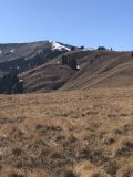
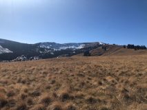
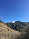
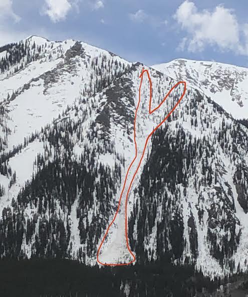
Snowpack: See attached photos. Thin snow coverage prevails on high, shady aspects of Cement Mountain. Expect similar coverage to exist higher up Cement Creek

Photos:

Early season snow coverage

CBAC2020-21 Observations

Zone: Northwest Mountains

Location: Slate River to Paradise Divide to Schofield Pass

Date of Observation: 11/06/2020

Name: Zach Guy and Eric Murrow


Subject: Early season snow coverage

Weather: Mild temps, mostly cloudy skies, light winds.

Snowpack: Shallow coverage (a few inches or less) of late October snow remains on northerly aspects (NE, N, NW) near and above treeline. Snow coverage is mostly melted off on E – S – W aspects. On high, shady aspects, the thin snowpack is weak: 2mm, fist hard facets.  On warmer slopes, the snow is capped by a melt-freeze crust of varying thickness. Because of the thin snow coverage, the weak layer is discontinuous on a majority of northerly terrain, interrupted by clumps of grass, talus, etc. However, some of the smoother alpine bowls or heavily shaded pockets near treeline have relatively continuous coverage. Start zones such as Redwell Basin on Emmons, Halloween Bowl and Emerald Bowl on Baldy, and the slopes above Purple Bench are examples of the latter. See photos for various examples through the terrain.

Photos:

New forecast platform

CBACAnnouncements, Avi Blog, Backcountry Notes

We have a few exciting changes to announce as we gear up for winter, including a new forecast platform and new forecast zones!

Forecast Platform

We are adopting the National Avalanche Center’s new forecast platform.  The new platform has some great upgrades for our users to help us better communicate our safety messages to you.

  • It’s mobile-friendly.  More and more of our users are now accessing the forecast from their phones. The new forecast pages will now adjust to fit your phone or tablet, making it easier to read our forecasts on the go.
  • Better media.  We now have the ability to add photos, videos, and captions within portions of the forecast to help illustrate avalanche problems or travel advice more clearly to you.
  • Bottom line and problem descriptions. While the basic layout of the forecast page will look similar to years past, this platform allows us to add a bottom line and problem descriptions.  The bottom line will highlight the key points of the forecast, and the problem descriptions allow us to provide dynamic travel advice for each avalanche problem as conditions evolve.
  • Conditions blog.  We’re experimenting with a “Conditions Blog” tab that can accompany the forecasts.  This is where we will provide weekly summaries and bonus material that supplements the forecast. More info for you at your fingertips!
  • Consistency.  There are about 8 or 9 other avalanche centers around the country that are adopting the same platform.  If you go skiing or riding in the Sawtooths, or Cascades, or Sierras, or any number of other mountain regions around the West, you can expect to see avalanche information presented in the same format as ours.  That makes it easier for you to digest the info and communicate with your partners.

New Forecast Zones

This map, which lives on our homepage, will show the daily avalanche danger rating for each of the two forecast zones. Clicking on a forecast zone will lead you straight to the forecast.

As most of our regular users know, the Crested Butte backcountry often develops into distinct snow climates: one with a deeper snowpack to the west and north of town, and one with a shallower snowpack near, east, and south of town.  In the past, we often use the text to describe nuances between the snow-favored parts of the forecast area and the drier parts of the forecast area.  Now, with our new forecast platform, we are integrating two forecast zones: the Northwest Mountains and Southeast Mountains.   This change allows our forecasters to better highlight spatial differences in the avalanche danger, travel advice, or size and distribution of avalanche problems.   We divided the zones based on our historical understanding of where the deeper and shallower snowpacks commonly develop.  Our homepage has a map of the forecast zones to reference these boundaries.   The Northwest Mountains include the snow belts of the Anthracite Range, Kebler Pass, Ruby Range, and Paradise Divide.  The Southeast Mountains include the drier parts of our forecast area such as Cement Creek, Brush Creek, the Gothic area, and some terrain close to town such as Red Lady Bowl, Climax Chutes, Coneys, and Snodgrass.  Our forecast team expects that there will be plenty of days where the forecasts for each zone will be exactly the same.  However, there will also be days where we highlight important differences.  For you, it’s simple. Click on the forecast map or select the forecast zone for the region that you plan to travel in for the day. That will lead you to the most current and relevant information.  Our detailed forecast discussion will be the same across both forecast zones to simplify the material for those folks who enjoy following the progression of the snowpack on a daily basis.  And as a reminder, these are regional forecasts that generalize conditions across a large area.  Although they should serve as a starting point for planning your day, you are responsible for assessing conditions on a slope by slope basis to minimize your avalanche risk.

Feel free to shoot us a message if you have questions about any of these changes!  cbavalanche@gmail.com


Zach Guy

CBAC Lead Forecaster

Schuylkill Ridge Wet Slabs

CB Avalanche Center2019-20 Observations

Location: Crested Butte Area
Date of Observation: 05/05/2020
Subject: Schuylkill Ridge Wet Slabs
Aspect: North East
Elevation: 11,200-9,200

Avalanches: Cornice triggered wet slabs running to the ground and to the valley floor. Yogi’s and the path just north of Easter Island.

Mt Emmons Wet Activity

CBAC2019-20 Observations

Location: Crested Butte Area
Date of Observation: 04/30/2020
Aspect: North East
Elevation: 11,400′
Avalanches:

Large cornice fall triggered a full-depth Wet Slab avalanche below.

Reported by Ben Pritchett-CAIC


Repeat offender day after day: Wet Slide on Whetstone Bear Claw

CB Avalanche Center2019-20 Observations

Location: Crested Butte Area
Date of Observation: 04/30/2020
Name: Turner Petersen
Subject: Repeat offender day after day: Wet Slide on Whetstone Bear Claw
Aspect: North East
Elevation: 10,600
Avalanches:

Over the last few days I have watched the lowest bear claw on Whetstone shed snow. Wet slides started as small point releases a few days ago but while at work today I heard a loud “whoosh” noise while working in Skyland. I looked up to see muddy wet snow racing down the bottom of the path snapping small trees. The sound of this slide across a busy highway was impressive to me Along with the fact of three days of constant activity.

Weather: HOT. Rain event a few days ago with hardly any sort of freeze in the last few days.
Snowpack: N/A observed from road

Preliminary Accident Report Climax Chutes Wet Slab Fatality

CB Avalanche Center2019-20 Observations

Location: Crested Butte Area
Date of Observation: 04/29/2020
Subject: Preliminary Accident Report Climax Chutes Wet Slab Fatality
Aspect: North East
Elevation: 10,000

PRELIMINARY ACCIDENT SUMMARY: A group of four backcountry skiers ascended Mount Emmons. Descending the northeast side through an area known as the Climax Chutes, the group triggered a shallow long-running wet-loose avalanche. The group descended a ridgeline one-at-a-time, with Skier 1 leading. Skier 1 triggered several more wet-loose avalanches, then descended out of sight down the steepening ridge. The group continued down the ridge after losing contact with Skier 1. One of the wet-loose avalanches carried Skier 1 over a cliff and triggered a deeper, and larger, wet-slab avalanche. The avalanche carried Skier 1 down a very steep, timbered slope. The group found Skier 1 unconscious and injured on the treed slope. They attempted to revive him, but his injuries were too severe. They made contact with local first responders, who assisted the group back to the trailhead. Skier 1’s body was recovered the following day.

You can read the Preliminary Report here.

Photos:

[/gravityforms]

Below Treeline Snodgrass Observations

CB Avalanche Center2019-20 Observations

Location: Crested Butte Area
Date of Observation: 04/28/2020
Name: Ian Havlick
Subject: Below Treeline Snodgrass Observations
Aspect: North East, East, South East, South
Elevation: 9800-10,400
Avalanches: No wet slabs observed in terrain travelled or surrounding terrain on Belleview, White, Avery, etc. Some larger wet loose avalanche gouging down to ground on west facing terrain visible from, ski out in late afternoon on White Mtn.

Weather: Overcast and extremely warm with car thermometer at TH at 0830 showing 46º and field measurements in the +8C (48F) range. High overcast clouds persisted until about 1130. Light NW winds were persistent in the afternoon.

Snowpack: Average height of snow in areas throughly dug (21 profiles last 2 days) and extensive transects show average HS 85-110cm with dark timber holding most snow currently. Freeze on April 26th was most pronounced in open areas, with darker timber not seeing full freeze with longwave radiation retention. Although fully isothermal in all profiles, large batch of free water and pronounced “wetting fronts” visible to naked eye being held up by various old melt freeze crusts 30-50cm deep in snowpack. Weak, smaller grained 4F and Fist hard snow below those crusts and pooling free water. Concerning.


Photos:

[/gravityforms]

Wet slides in Washington Gulch at similar aspect/elevation to accident

CB Avalanche Center2019-20 Observations

Location: Crested Butte Area
Date of Observation: 04/28/2020
Subject: Wet slides in Washington Gulch at similar aspect/elevation to accident
Aspect: North East
Elevation: 10400
Avalanches:

In light of the accident today I wanted to reach out with some info about the conditions today. I was in Washington Gulch and skinned 4/5th up Coney’s. At 9am at roughly the same aspect and elevation as the accident, I was able to trigger small slides on a 30-35o test rollover. There was poor refreeze overnight and in many places I could easily punch a pole 2.5-3ft (probably to the bottom of the snowpack). I topped out at about 10.8k ft and conditions did not improve with further elevation gain.

Don’t know if this is helpful or not. Condolences to everyone involved.


Weather:

Snowpack: