Dry north, swampy south on Baldy

CBAC2020-21 Observations

Date of Observation: 03/06/2021
Name: Eric Murrow Jared Berman


Zone: Northwest Mountains
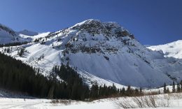
Location: Baldy south side and northwest side
Aspect: East, South East, South, South West, West, North West
Elevation: 9,400′ – 12,400′


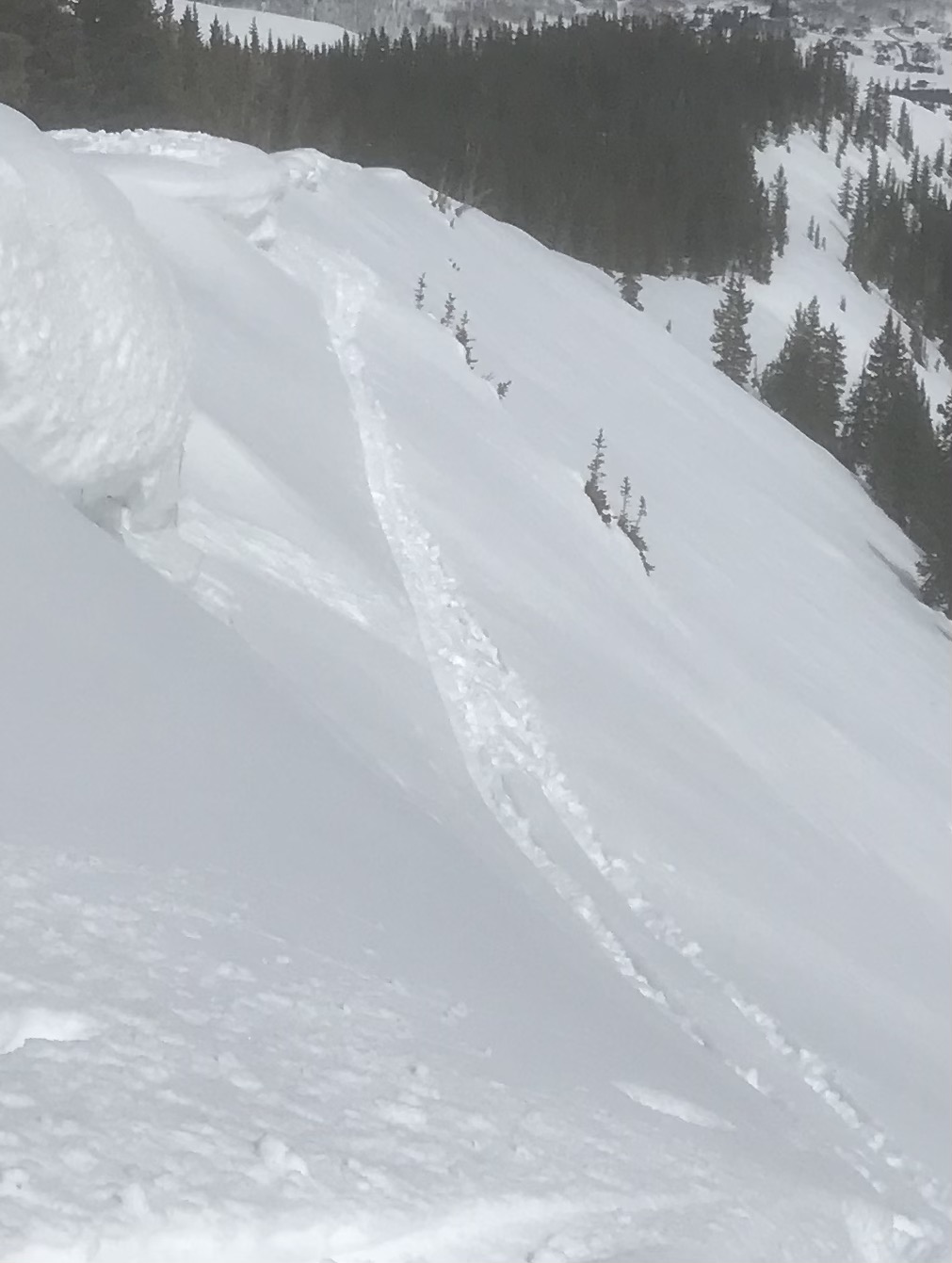
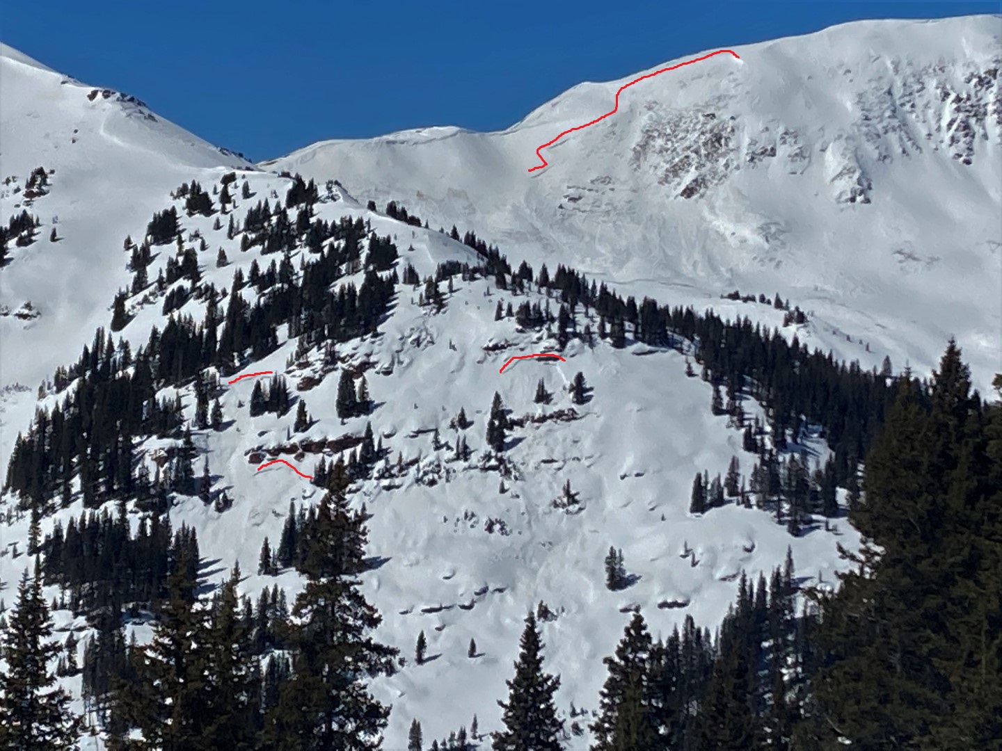
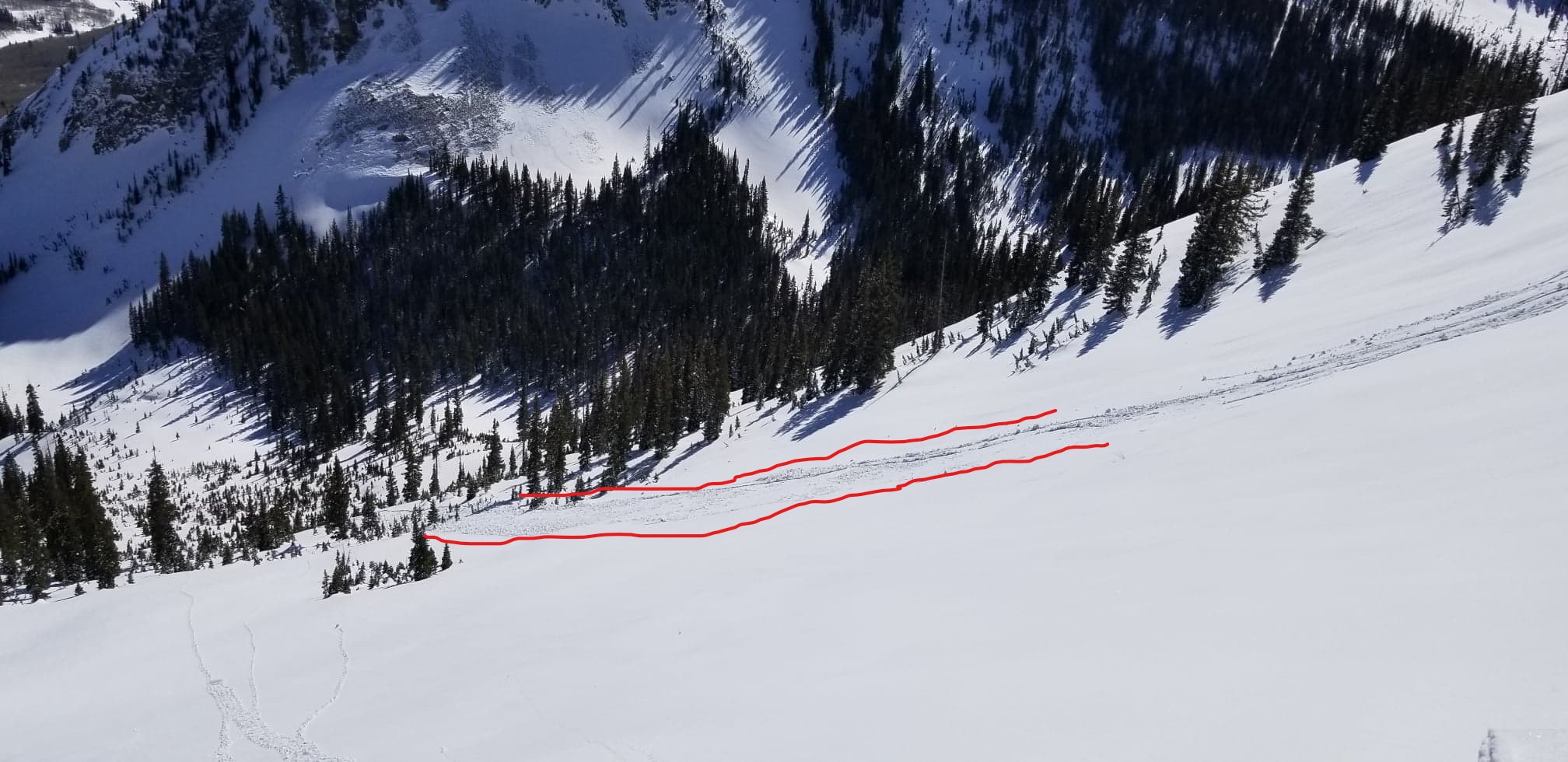
Avalanches: Observed a healthy number of small D1 loose avalanches from Friday throughout Ruby Range (most originated from steep rocky areas with some degree of southerly tilt), but did not notice any fresh avalanches today. Returned to town at dark, so was unable to look around the range from the pavement with binos.
Weather: Thin high cloud cover, very warm temperatures, and generally light winds 5 -15mph above treeline.
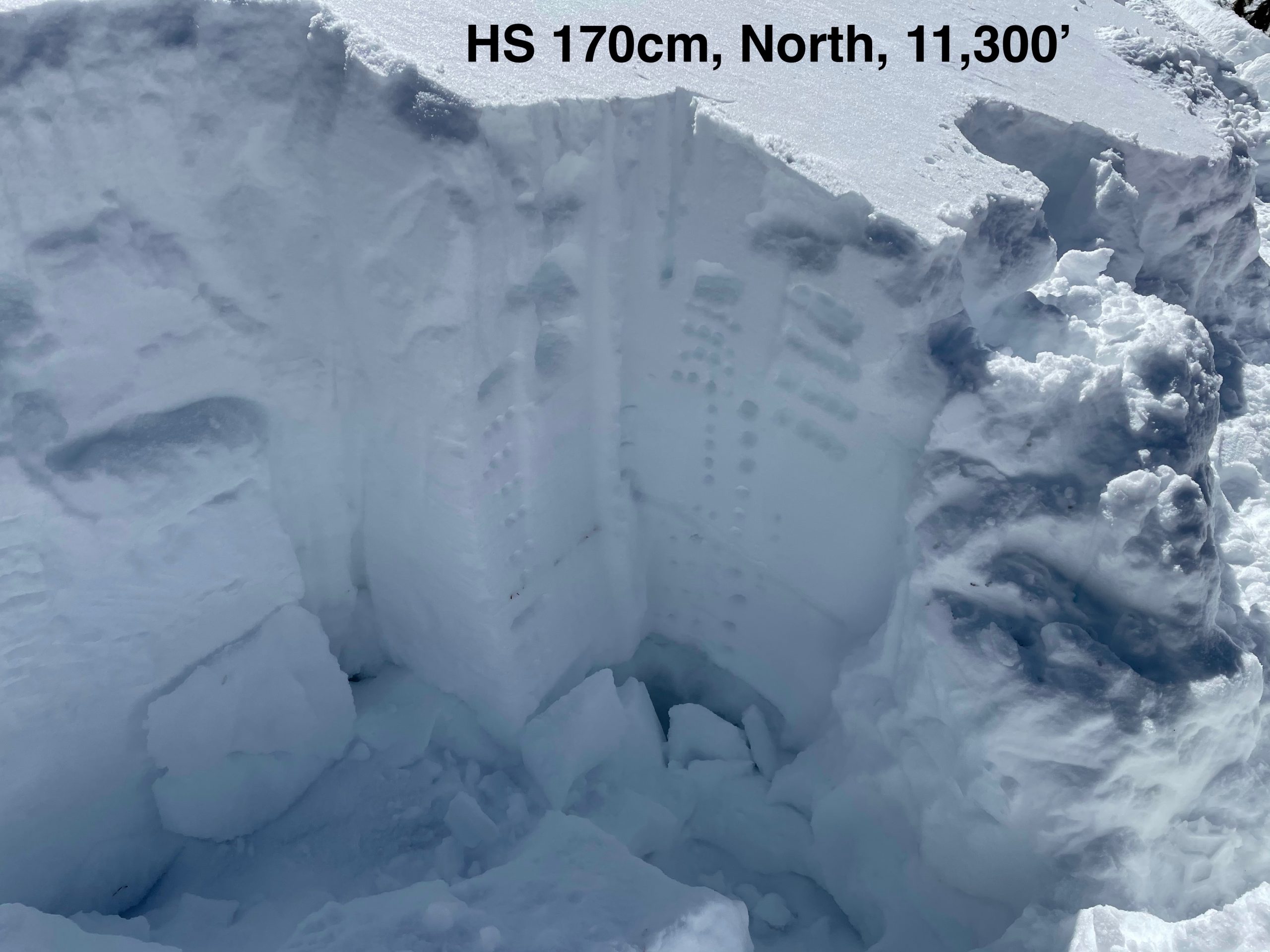
Snowpack: Ascended southerly-facing terrain that had soft, slightly moist surfaces up through 12k by noon. Descended down through northwesterly terrain near treeline and found surprisingly soft surface conditions. Ascended back up through said NW near treeline terrain and probing revealed HS between 120cm and 220cm. We dug a test profile at a site with HS of 150cm and found around 115cm slab resting over weak Depth Hoar at ground (4finger- hardness) – ECTX and PST 52/110 END. Here there are two layers of concern, basal depth hoar and weak near-surface facets buried by 20cm of recent snow.

Late in the day we traveled over E, SE, S, and SW slopes near treeline and found wet snow conditions. On a SE slope at 11,600′, with HS of 135cm, meltwater has percolated about 75cm down.  A weak facet/crust layer just above ground has yet to see water infiltration. I would anticipate liquid water to reach the ground at this site within the next two days if forecasted temperatures verify Sunday and Monday. One SW feature at 10,800′ had trenchy, wet conditions as we skied over with a dramatic increase in ski pen around 10-12 inches.


Coon Basin wet slab

CB Avalanche Center2020-21 Observations

Date of Observation: 03/06/2021
Name: geo bullock


Zone: Southeast Mountains
Location: North side of coon Basin
Aspect: South East
Elevation: 11,500


Avalanches: I triggered an avalanch 8-18″ deep and 70′ wide, ran 500′ vertical to the bottom of coon basin.I traversed under the cornice intending to take an easier route and quickly went from dense snow to shallow wet snow and rocks (see picture).went for a ride maby 200′.managed to stand up on my skis (see dirt spot) and let it pass. the intention was to ski down the ridge not coon basin. I was too late in the day to be on that pitch. the slope angle at the trigger point was at least 40
Weather: high overcast light breeze 40 degrees
Snowpack: 65cm wet snow


Photos:

GMT-Reboot

CB Avalanche Center2020-21 Observations

Date of Observation: 03/06/2021
Name: Andrew Breibart


Zone: Northwest Mountains
Location: GMT Reduction (East River-Paradise Divide-Washington Gulch)
Aspect:
Elevation: BTL, NTL


Avalanches: didn’t take pictures of the wet loose avalanches on south aspects of Baldy and east aspects of Gothic.

1. Mt Belleview-NTL on W/SW aspect: slab avalanche (D1 to D2) CBAC NOTE – reported 2/22 ob here
2. Mt. Baldy-NTL on SW aspect wet slab
3. Coneys-BTL on E/NE aspect: slab (D0.5-D1) CBAC NOTE – reported 3/2 ob here
Weather: Temperatures remained lower than yesterday’s sauna due to thin cloud cloud cover. Calm.
Snowpack: snow is transitioning rapidly on southern aspects BTL as a melt freeze crust develops.


Photos:

Coon Basin skier-triggered Wet slab

CBAC2020-21 Observations

Date of Observation: 03/06/2021
Name: Zach Kinler
Zone: Southeast Mountains
Location: Coon Basin
Aspect: South East
Elevation: NTL


Avalanches: Wet slab avalanche that ran sometime before 1:30 pm. A later report from the party involved revealed this was a skier-triggered avalanche. An observation will be submitted by the reporting party.


[/gravityforms]

Cement Creek

CB Avalanche Center2020-21 Observations

Date of Observation: 03/05/2021
Name: Ben Pritchett and Bo Torey


Zone: Southeast Mountains
Location: Upper Cement Creek and Upper Taylor River
Aspect:
Elevation: up to 9,000-12,400′


Avalanches: 3 small wet loose avalanches ran above treeline on steep rocky south-facing slopes in the Upper Taylor River headwaters. Surprisingly no other wet loose avalanches observed. Numerous roller balls seen, but none that gouged or spread into a pushy wet avalanche.
Weather: Ridgeline Wind Speed: Calm
Temperature: 43 F
Sky Cover: Clear
Depth of Total Snow: 150 cm
Weather Description: Warm, calm day. No blowing snow observed.
Snowpack: The upper snowpack is gaining strength and making it more difficult to influence weak snow below. Average snowpack in the upper Cement Creek and upper Taylor River headwaters area ranged from 130-160cm. Multiple ECT’s failed to produce propagating results in the normal loading steps. Removing part of the slab, and slamming on the remaining thin slab did produce a propagating result in one profile. East to south to west-facing slopes with a lot of sun have grown crusty, with rills developing in the snow surface near and below treeline. We experienced a pair of collapses, with long-running shooting cracks, over 50′ long, in the valley bottom. Alpine surfaces are highly variable, with a few inches of fresh snow obscuring highly textured and dense old wind textures. Near treeline shady surfaces were soft, but dense enough for reliable sled and boot support.


Photos:

Kebler Pass corridor

CBAC2020-21 Observations

Date of Observation: 03/05/2021
Name: Eric Murrow


Zone: Northwest Mountains
Location: Snowmobile journey to Beckwith Pass and up into Evan’s Basin on Mount Emmons.
Aspect: East, South East, South, South West, West
Elevation: 8,900′ – 11,200′


Avalanches: Observed loose snow avalanches on sunny slopes near and above treeline, generally coming from warm, rocky terrain features. Up to D1.5 in size. Overall significantly less activity than I expected to find. See photos for examples. Observed one natural run on alpine SE slope at 1:30 pm.
Weather: Clear skies, light winds, and warm temperatures above freezing.
Snowpack: Around 7″ storm snow on top of Kebler Pass and Beckwith Pass.  5″ on lower flanks of Mount Emmons.

I targeted a shaded slope in a shallower snowpack area on the far west end of the forecast area near Horse Ranch Park. I found HS 120cm with dense slab around 75cm thick sitting on old snow from early in season – ECTP 28 x2 result failing in oldest weak snow near ground. 1/19 interface shows clear sign of rounding and no result here. Oldest snow at ground was 3-4mm Depth Hoar – it is starting to round and sinter with around 4finger hardness. Late February weak layer is down 20cm, .5 -1mm facets with ECTN 11 and easy Shovel Tilt Test results.

In the afternoon traveled on southerly-facing slopes checking in on where liquid water was in the snowpack. On several slopes found moist snow from the surface to the ground. Ice columns from percolating meltwater was found nearly all the way to the ground – with around 20cm of moist, 4finger hard snow at the ground without ice columns. Tests produced no result on these slopes even while hammering on the column until my hand hurt. See photo of ice columns.


Photos:

So Good While It Lasted

CBAC2020-21 Observations

Date of Observation: 03/05/2021
Name: Evan Ross

Zone: Northwest Mountains
Location: P-Divide
Elevation: 9,000-11,800ft

Avalanches: Wet loose avalanches happened, but no widespread and all on the small size. Some east, some south, some west, they all had a little action.

Weather: Calm winds, warm temps, clear sky, beautiful.

Snowpack: Well, that snow sure was good while it lasted! Lots of now crusty snow surfaces heading into tomorrow, until they warm back up again… The recent snow seemed to just bake in, more than release as wet loose avalanches. Hard saying just how reactive it will be on the next warm-up after today. We slammed a whole lot of terrain features, many in the upper 30 degrees, and didn’t find any signs of instability regarding PSa. Still considering regrouping areas for the low likelihood avalanche problem. If anything, upper elevations looked like the best chance to find a thick snowpack transitioning to a thin snowpack due to previous winds.

We descended a SW aspect between 11,000-10,00ft at 3:30pm with slope angles in the upper 30 degrees. The new snow on that slope felt more baked in and we didn’t see any movement.

Elk Crest obs

CBAC2020-21 Observations

Date of Observation: 03/01/2021 to 3/05/2021
Name: Zach Guy


Zone: Southeast Mountains
Location: Elk Crest near Friends, Lindley, and Opa Huts.
Aspect: Various
Elevation: 10,000 – 13,200


Avalanches:

-2 small wind slabs ran naturally on Thursday near Taylor Pass
-2 large wet slabs ran naturally, likely on Wednesday, on a SE bowl of Leahy Peak (on the Aspen side of the divide). They failed near the ground, probably triggered by water draining into basal weak layers near rock outcrops. The debris looked fairly wet, I suspect the slabs were a mix of dry midpack, wet on the surface.
-1 recent persistent slab on Carbonate Hill, triggered by a cornice fall, likely during the warmup on Tuesday or Wednesday
-1 small loose wet ran near Star Peak on Tuesday.
-Dozens of previously undocumented large persistent slabs (up to D2.5) that ran mid-February or from subsequent wind events at all elevations and aspects.
Weather: Warm and sunny most of the week. Thursday brought 3″ of snow and gusty northwest winds. Back to warm and sunny on Friday.
Snowpack: Spent the last five days on a hut traverse in the upper Brush, Cement, Castle, and Tayler drainages. No signs of persistent slab instabilities underfoot, such as collapsing. Winds during the later half of February have heavily redistributed the snowpack above treeline; quite a bit of scouring, even on some leeward aspects, while some areas have a hard, thick snowpack with basal weak layers down 150 to 200 cm. In shallow areas at higher elevations and on most below treeline slopes, slabs have generally faceted away.
Snow surfaces are mix of sastrugi/windboard ATL, facets on shady BTL aspects, and melt-freeze crusts up to a few inches thick on the southern 2/3 of the compass. All of this was buried by about 3″ of snow on Thursday. We also noted small-grained surface hoar that formed last night at all elevations.


Photos:

Hot as Tomales

CB Avalanche Center2020-21 Observations

Date of Observation: 03/05/2021
Name: Jared Berman, Zach Kinler
Zone: Northwest Mountains
Location: Anthracites
Aspect: North, North East, South East, South
Elevation: 10,000′- 11,500′


Avalanches: From a distance, we could see several small loose wet avalanches initiating below rock bands on steep east and southeast facing terrain in Elk Basin and Evans Basin near treeline.

In the Anthracites, one D1.5 natural loose wet was observed below treeline on a southeast slope while another was intentionally triggered on a south facing slope. Both ran into the basin locally known as the Playground (see photos below).
Weather: Clear skies, calm winds, and above freezing temperatures.
Snowpack: Drastically variable snowpack depending on aspect below treeline and near today.

On north and northeast facing slopes, probing revealed the average snowpack depth being 150cm deep with some areas as deep as 200cm. We measured 8″ of new snow on these slopes with 0.75″ of snow water equivalent. We did observe faceted grains at the old/new interfaced as well as small faceted grains at the snow surface.

On south and southeast facing slopes below treeline, the snowpack averaged 90cm deep. A hasty pit revealed moist snow all the way down to the ground with obvious signs of free water(vertical and horizontal ice columns)  through the upper half of the snowpack.


Photos: