Student led tours – Coney’s & Snodgrass

CB Avalanche Center2019-20 Observations

Location: Crested Butte Area
Date of Observation: 02/09/2020
Name: AIARE 2 – Irwin Guides
Subject: Student led tours – Coney’s & Snodgrass
Aspect: North East, East
Elevation: 9,400 – 10,900

Avalanches: None Observed

Weather: Temp: Upper 20’s
Wind: Calm
Precip: Light snow with periods of S-2
Sky: Overcast

Snowpack: Coneys:
No signs of instability observed
Rode terrain in low 30’s
Pit:
Incline 26
Elevation 10’600
Aspect: N/NE
Temp -3
HS: 140
New snow old snow intercase 35cm down (Fist Hardness)
CT12 SP 25cm down (Within New snow old snow interface)
CT17 Brk 35cm Down (new snow old snow interface) ECTN 16
CT 26 Brk 60cm down
Snowpack below New Snow was 4F, 50cm to ground was 1F (all faceted grains but seemed to be gaining strength)

Snodgrass:
No signs of instability observed
Rode terrain in low 30’s
Pit:
Incline 26
Elevation 10’370
Aspect: E
HS: 140
New snow old snow intercase 30-40cm down (Fist Hardness)
ECTN 23 30cm Down (new snow old snow interface)
Rest of the snowpack below New Snow was 4F (they where still faceted grains but seemed to be gaining strength)
Base of snow pack 10cm 1F hardness
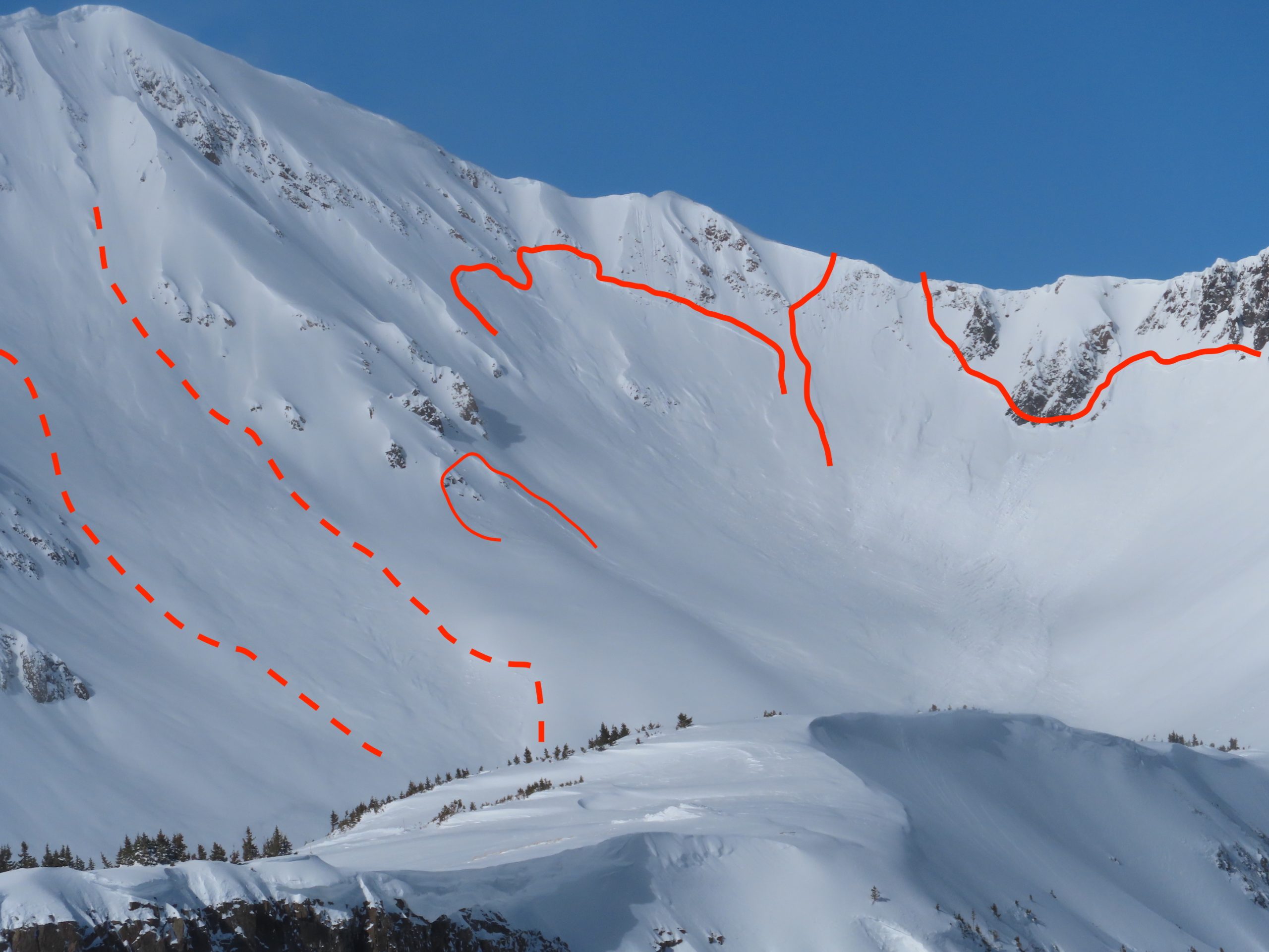
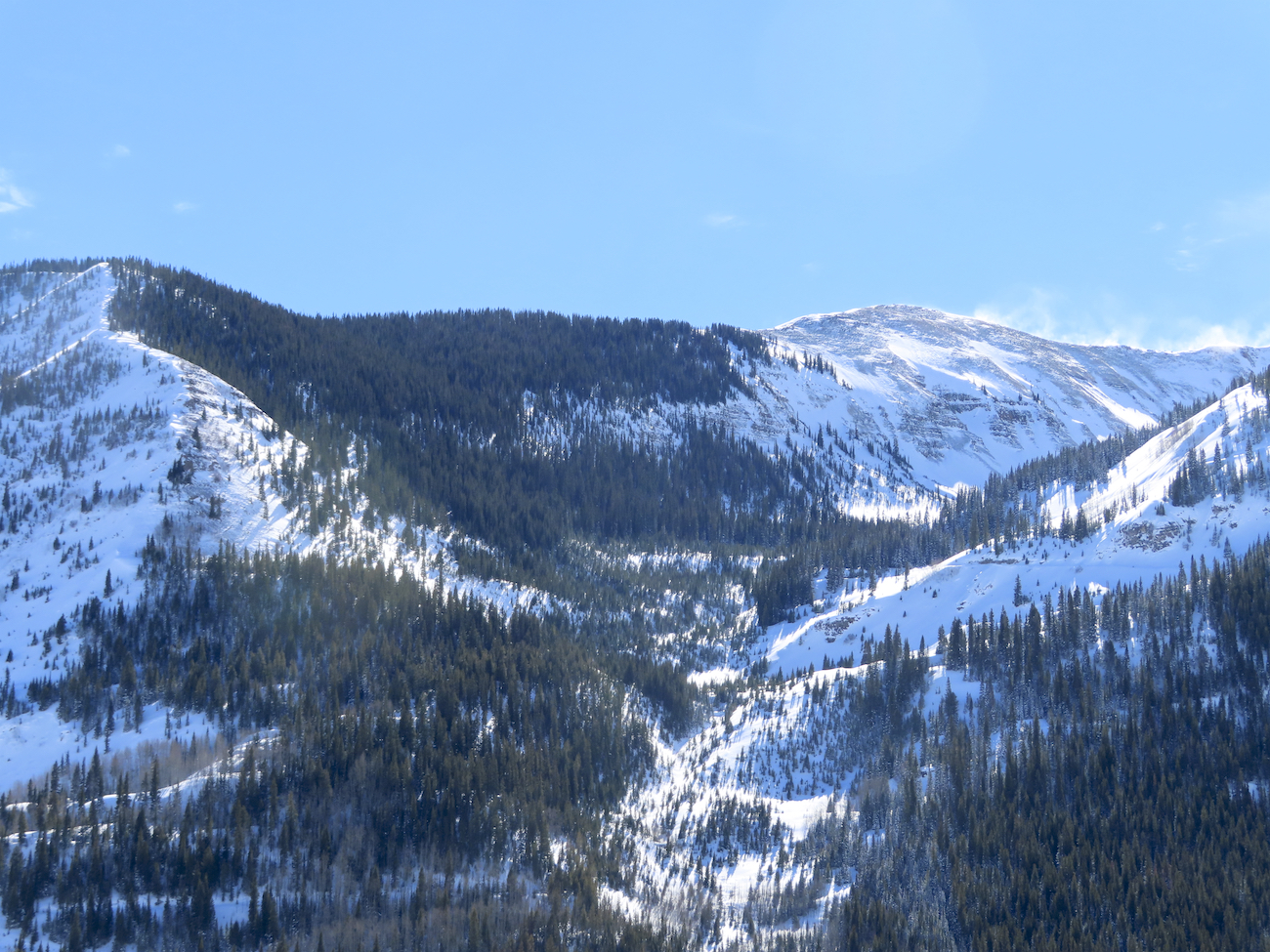
Photos:

[/gravityforms]

A few more avalanche pics

CB Avalanche Center2019-20 Observations

Location: Kebler Pass Area
Date of Observation: 02/08/2020
Name: Zach Kinler

Aspect: North East, East, South East, South

Avalanches:

Several large above tree line avalanches from the Kebler Pass area on east-south facing terrain features which took the brunt of loading and winds from our recent storm. Several of these broke into old weak layers in the upper snowpack.

Photos:

Large avalanche on East aspect in Anthracite Range

Large avalanche ENE aspect on Beckwith

South flanks of Purple Pk.

South flank of Ruby, ESE aspect

East aspect Ruby Pk

4 slab avalanches on Mt Owen, NE-SE. Looker’s left 3 avalanches previously reported.

Cement Creek

CB Avalanche Center2019-20 Observations

Location: Cement Creek Area
Date of Observation: 02/08/2020
Name: Cosmo
Subject: Cement Creek

Avalanches: Big slide on north facing terrain NTL off of Cement around 11k’. Can’t tell how far the debris ran. Another very small natural slide on east facing terrain BTL around 9400′ that I didnt get a picture of.

Snowpack: Storm total at 9400′ was roughly 13″. Got very warm on 2/8 and there is a thin sun crust in places on morning of 2/9.

Photos:


Mountain Weather for 11,000ft

CB Avalanche CenterWeather

Date: 02/09/2020

A weak system and associated cold front are oozing south through Colorado today. This will bring cooling temperatures and light snowfall for the Crested Butte area. Snowfall today is expected to produce up to 4 or so inches of accumulations on the high end. Winds are forecasted to remain out of the southwest today at much more reasonable speeds than yesterday, but they will likely still be strong enough at ridgetops to transport some snow.

A more substantial low-pressure system further to out west will begin impacting the area on Sunday night. This system is expected to close off and separate from the jetstream and wobble from southern California towards Arizona and New Mexico. You can expect modest snowfall from Sunday night through about Tuesday morning. This system has a decent amount of moisture but is forecasted to track in a less-favorable direction for snow production in Crested Butte, but trajectories for closed low-pressure systems can be tricky.

  • Today

    High Temperature: 23 to 27
    Winds/Direction: 5-15/SW
    Sky Cover: Mostly Cloudy
    Irwin Snow: 2-4″
    Elkton Snow: 2-4″
    Friend’s Hut Snow: 2-4″

  • Tonight

    Low Temperature: 8 to 12
    Winds/Direction: 5-15/SW
    Sky Cover: Overcast
    Irwin Snow: 2-4″
    Elkton Snow: 2-4″
    Friend’s Hut Snow: 2-4″

  • Tomorrow

    High Temperature: 26 to 30
    Winds/Direction: 10-20/WSW
    Sky Cover: Overcast
    Irwin Snow: 2-4″
    Elkton Snow: 2-4″
    Friend’s Hut Snow: 2-4″

Slate River And Lower Brush Creek

CB Avalanche Center2019-20 Observations

Location: Crested Butte Area
Date of Observation: 02/08/2020
Name: Evan Ross
Subject: Slate River And Lower Brush Creek

Avalanches: At the moment, avalanches are currently documented in photos.

Weather: Hot and heavy. Calm winds in the Slate River Valley. Light to Moderate winds in lower Brush Creek in the Afternoon. Blowing snow could be seen off many peaks and ridgelines throughout the day.

Snowpack: Started a late morning off in the Slate River Valley near Pittsburgh on primary SW facing slopes but a little south and west in there too. Low elevation between 9,500ft to 9,800ft. #tired, didn’t make it very far. No significant signs of instability while traveling on those slopes. The 2/4 crust was down about 30cm. The snow on the crust was thick from both quick settlement and the warm temps. There will be a new surface crust on some of those slopes. The 2/4 crust was unreactive underfoot and with some extra effort. In low 30-degree terrain that crust was around 3cm thick. I searched for areas that the crust was thinner and still couldn’t get a collapse. Boot Pen was just to, or just below, the crust depending on the slope angle. Hand Pits were difficult to pull off the Storm Slab and didn’t produce results on the 2/4 crust. Got one very small result on a wind-loaded steep thing where the new snow released as a very small slab on the 2/4 crust.

Got a quick look out Lower Brush Creek in the afternoon. Measured about 7″ of newly settled snow on a protected and shaded slope. Sunny slopes were zapped back to just a couple inches new. Plenty of bushes about.

Winds in southeast zone

CB Avalanche Center2019-20 Observations

Location: Cement Creek Area
Date of Observation: 02/08/2020
Subject: Winds in southeast zone
Aspect: North
Elevation: 12,000

Avalanches: Impressive wind loading in all of Taylor zone. Small storm slab avy located on lower Matchless Mtn.. Fallen cornice debris on upper Matchless.

=Weather: Sunny, windy, warming

Snowpack: 11” of fresh storm snow in protected areas. 18-20” in wind loaded zones.

Photos:

[/gravityforms]

Anthracite Mesa-Coneys

CB Avalanche Center2019-20 Observations

Location: Crested Butte Area
Date of Observation: 02/08/2020
Subject: Anthracite Mesa-Coneys
Aspect: North East, East
Elevation: BTL

Avalanches: CBAC will likely have a better picture for storm slab on SW bowl on Baldy from cross loading. Untrained eye would call it around R2 size.
A few loose snow slides with minimal snow entrainment low on southerly open slopes by Mosquito cabin at Elkton.

Weather: AM blowing snow on Baldy peak.
PM blowing snow on Mt CB and Mt Whetstone. Blowing snow BTL on Gibbs Ridge and BTL on Mt CB on Brush Creek side.

Anthracite Mesa: calm to light winds on ridge. scattered to broken skies. warming throughout the day to above freezing in town.

Snowpack: no collapsing, cracking or whumping on new skin track. boot pen with 118 lb person: 35 cm (14 inches).
due to wind packed and dense snow could not determine new snow/48hours.
snow stuck to ski bases at end of tour.

Gothic Townsite Obs 0600

CB Avalanche Center2019-20 Observations

Location: Crested Butte Area
Date of Observation: 02/08/2020
Name: billy barr

Subject: Gothic Townsite Obs 0600

Weather: Snowfall was off and on Friday and once again wind driven so very dense, then none overnight so 24 hour total (unless it snows in the next hour) is 3" new and 0.35" of water. Cloudy and warm overnight as wind continued though for an hour or two it let up. Then started back but not as strong as the past few days and seems to be residing now. Snow has been drifted everywhere. Current the sky looks cloudy with the overnight high temp 27F, low 24 and current 26F. Snowpack at 36" and wind is light to moderate with occasional gusting. No measurable snow since late day yesterday. billy

Mountain Weather for 11,000ft

CB Avalanche CenterWeather

Date: 02/08/2020

Yesterday’s storm has shifted to the eastern plains this morning, leaving cold northwest flow in its wake. The highest peaks of the Ruby Range and Elk Mountains may see some lingering light snow showers but should generally be a quieter, sunnier day before the next round of snowfall develops tonight as another cold front drops into Colorado from the north, bringing 2-6” snow overnight. West winds today will start in the 10-20mph range at treeline, but increase midday through this evening into 30-40mph territory. Sunday and into next week looks unsettled, mostly cloudy, with spotty snow showers and light accumulations until about Wednesday.

  • Today

    High Temperature: 20 to 25
    Winds/Direction: 15-25 G40/WNW
    Sky Cover: Partly Cloudy
    Irwin Snow: 0-2″
    Elkton Snow: 0-2″
    Friend’s Hut Snow: 0-1″

  • Tonight

    Low Temperature: 10 to 25
    Winds/Direction: 5-15/WNW
    Sky Cover: Mostly Cloudy
    Irwin Snow: 2-4″
    Elkton Snow: 1-3″
    Friend’s Hut Snow: 1-3″

  • Tomorrow

    High Temperature: 15 to 20
    Winds/Direction: 5-15/WNW
    Sky Cover: Mostly Cloudy
    Irwin Snow: 0-2″
    Elkton Snow: 0-2″
    Friend’s Hut Snow: 0-2″

Irwin Cat Tenure

CB Avalanche Center2019-20 Observations

Location: Kebler Pass Area
Date of Observation: 02/07/2020
Name: Snow Safety Teams

Subject: Irwin Cat Tenure

Weather: Hola,

An initial decision to delay guest departure while assessing conditions evolved into a cancellation decision before we were half way up Kebler to Irwin. Significant avalanche hazard and road conditions impassable for the Tucker got us part way there. Combining that with a forecast of increasing hazard through the day made the decision obvious.

Snow safety teams continued up and ran control routes to prep terrain. Travel on skis was extremely difficult due to a profound density inversion in the new snow. Normal egress routes that should take 2-3 minutes were 20-30 minute slogs. Ski cutting was almost impossible due to the inability to maintain forward progress. Rescue would have been very time consuming and difficult. Guests would not have had fun with us today.

Our unsettled storm total at noon was 34" with 2.4" of water. It was snowing S2 when we left at 13:00. Fresh slab was notably stubborn to explosive testing, but accompanied by widespread collapsing. Spooky.

Time to make soup. We'll try again tomorrow. cheers…dk

Snowpack: