East to South East NTL Purple Palace Zone

CB Avalanche Center2018-19 Observations

Location: Paradise Divide Area
Date of Observation: 12/26/2018
Name: CBAC

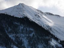
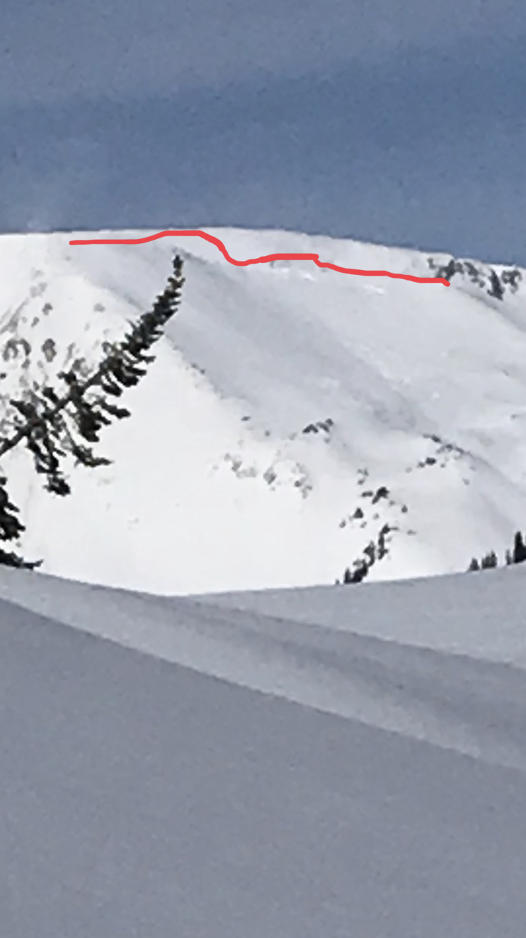
Subject: East-South East NTL Purple Palace Zone
Aspect: East, South East
Elevation: 10,300′

Avalanches:

Observed a few small remains of some size .5-1 storm slabs that ran mid storm.

Weather: Nice sunny day with some clouds lingering to the NW. Temperatures remained in the 20’s today, but the solar radiation was intense throughout the mid part of the day. Winds remained calm down low and light at ridge tops until around 3PM then winds increased slightly with light snowfall increasing until last observed at 4 PM.
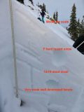
Snowpack: Snow depths NTL we found the avg. depth to be around 100cm . Solar radiation was intense the top 10 cm of the pack was WET! gloppy wet on E-SE aspects mid-day. On Specific wind loaded features east to southeast, we found a 1F slab over weak rounded facets below a crust on the December 19th layer around 2′ down. This is a layer of concern to keep an eye on as more possible snow or wind transport puts more weight on this interface. Three different ECT tests all resulted with propagation ECT 14-17. The crust was not as well developed on E but as we wrapped around more SE there was a distinct crust sandwich coated and filled with facets. Observed a small portion of N aspect NTL the slab was not as present there, the N aspect snow stayed cold throughout the day and lacked a reactive slab structure in the upper snowpack.

Photos:

Mountain Weather for 11,000ft

CB Avalanche CenterWeather

Date: 12/26/2018

The closed low is currently in Southern Arizona. This system has been streaming good moisture into Western Colorado overnight and that moisture stream is currently just west of our area. Snow is stacking up on the Grand Masa overnight, with light snow in Irwin at 5am. Of course, the snow is stacking up in the San Juans too. What about us you ask? Well, the band of snow is sooo close. Yet models don’t show it pushing east this morning before it dissipates. If that band of snow does push a little east than we should see some snow stack up on the west to northwest border of our forecast area. As the closed low moves east today, wind direction will flip a 180 and increase out of the north this afternoon. We have another small shot of snow later this afternoon. Then we’ll see a brief drying trend late Wednesday night or early Thursday ahead of the next low-pressure trough that will continue unsettled weather into the weekend.

With the current closed low. Our forecast area is kind of getting the donut hole treatment. If that makes you unhappy, go eat a donut.

  • Today

    High Temperature: 25
    Winds/Direction: 10 to 20. South AM, North Pm
    Sky Cover: Mostly Cloudy
    Irwin Snow: 2 to 4
    Elkton Snow: 2 to 4
    Friend’s Hut Snow: 1 to 3

  • Tonight

    Low Temperature: 10
    Winds/Direction: 5 to 15 NW
    Sky Cover: Mostly Cloudy
    Irwin Snow: 0 to 2
    Elkton Snow: 0 to 2
    Friend’s Hut Snow: 0 to 2

  • Tomorrow

    High Temperature: 20
    Winds/Direction: 5 to 15 W
    Sky Cover: Mostly Cloudy
    Irwin Snow: 0 to 2
    Elkton Snow: 0 to 2
    Friend’s Hut Snow: 0 to 2

North Below Treeline

CB Avalanche Center2018-19 Observations

Location: Kebler Pass Area
Date of Observation: 12/25/2018
Name: Steve Banks

Subject: North Below Treeline
Aspect: North, South
Elevation: 10,200-11,200

Avalanches:

Red Lady Bowl and south face of Ruby showed similar fresh avalanches from the end of the storm or overnight. Both were mid slope, storm slabs and looked to be small D2’s confined to the upper snowpack.

Weather: Mostly sunny with passing clouds. Cold in the morning with temps on the teens and warming through the day. Southerly winds at ridgetop blowing 20 mph and moving snow.
Snowpack: New snow averaged 10” and beginning to settle and consolidate some. Below teeeline N was still soft and good skiing, but on South it was becoming wet on the surface.
1 quick pit North faceing at 10,600’ showed 30 cms of new Christmas snow. A well consolidated 1F to Pencil slab below with 15-20 cms of large faceted grain near the ground. This layer was 4F to 1F and capped with stronger snow. HS of 130 cms.
Shovel tilt test revealed a clear shear about an inch or so below the new snow. Likely one of our buried surface hoar layers though it was difficult to see the SH. ECT showed a moderate failure in the midpack with no propagation.
Near treeline South winds were creating thick windslabs in the top of the starting zones. Some localized cracking noted.

Photos:

New Crusts and Quiet NE

CB Avalanche Center2018-19 Observations

Location: Paradise Divide Area
Date of Observation: 12/25/2018
Name: Evan Ross

Subject:
Aspect: North East, East, South East
Elevation: 9,000-11,200

Avalanches:

Observed previous avalanche activity in the last 24:
Natural D2 slab in RLB, SE Mt Emmons ATL.
Couple of Natural D1.5 loose snow avalanches in N facing Red well Basin.
Several natural loose snow avalanches in steep terrain BTL.

Weather: Broken cloud cover with enough sun and green housing to crust up those southerly facing slopes. Saw a few snow plumes off the higher points but on this tour the winds were calm.
Snowpack: For Jesus’ birthday in 2018 he said, Evan, I give you an avalanche problem free tour. Well, thats kind of what happened. The universe told me I wasn’t allowed to skin until late afternoon. So in the afternoon we crushed up some crusty south from 9,000ish feet to 11,000ft. Here the snowpack structure sucks for the future when we get bigger load, but for now it was a non issue in this terrain that didn’t have previous wind-loading. Couple notes in pics below for more information on that. For the same elevation change on the northeast side of the compass, we got a quick decent before the sun said it was the end of Jesus’ birthday. Played it real safe on the more NTL type terrain. Some hard ski cuts just off the ridge didn’t produce jack. Those cuts would have been in the thickest part of the slab for what it’s worth. Transitioning into the more BTL type terrain, the HS decreased as did the snowpack structure. Basically soft snow over weak snow. Some sluffing in steep terrain, but didn’t see any shooting cracks as I would have expected. I guess Jesus just had our back.

Photos:

Mountain Weather for 11,000ft

CB Avalanche CenterWeather

Date: 12/25/2018

Well, support for the Santa Makes Winter Great Campaign turned out to be a little low over the last couple of days. So now, Santa’s closed low is dropping down the California coast for some beach time early this morning. Drier air on southwest flow is being pushed into the area which could bring some breaks in the clouds today. Otherwise, we are still looking at a partly to mostly cloudy kind of day. Eventually, Santa’s Closed Low is going to make a stop on the Baja Border for a taco, then eventually move south and east of Colorado on Wednesday. Later in the week, a large low-pressure trough will continue to bring us unsettled weather.

What does this all mean for snow? Well, the storm’s energy is mostly staying south of Colorado. So we’ll be looking more at winds and orographics to turn the available moisture into snowflakes. Unfortunately, we don’t check that box as the wind directions are not the best for our local area. So, not a big hit of snow over the next 24hr, but we’ll still get some snow showers helping keep it fresh.

  • Today

    High Temperature: 27
    Winds/Direction: 5 to 15 South
    Sky Cover: Mostly Cloudy
    Irwin Snow: 1 to 2
    Elkton Snow: 1 to 2
    Friend’s Hut Snow: 1 to 2

  • Tonight

    Low Temperature: 15
    Winds/Direction: 10 to 20 SSE
    Sky Cover:
    Irwin Snow: 1 to 3
    Elkton Snow: 1 to 3
    Friend’s Hut Snow: 2 to 4

  • Tomorrow

    High Temperature: 27
    Winds/Direction: 5 to 15 WSW
    Sky Cover: Mostly Cloudy
    Irwin Snow: 2 to 4
    Elkton Snow: 2 to 4
    Friend’s Hut Snow: 1 to 3

Snodgrass obs

CB Avalanche Center2018-19 Observations

Location: Crested Butte Area
Date of Observation: 12/24/2018
Name: Alex Tiberio

Subject: Snodgrass obs
Aspect: North East, East
Elevation: 10,000

Avalanches:

Ski cut and triggered a couple small storm slabs on slopes over 35 degrees.

Weather: Snowing all day. 8” new snow
Snowpack:

Photos:

Christmas eve Keebler Pass powder day

CB Avalanche Center2018-19 Observations

Location: Kebler Pass Area
Date of Observation: 12/24/2018
Name: Eric Murrow

Subject: Christmas eve Keebler Pass powder day
Aspect: North, North East, East
Elevation: 10,000′ – 11,500′

Avalanches:

Observed on skier triggered slab in steep protected terrain, D1 in size. Part of this side only released storm snow and in a few places a second interface was visible which I assume to be 12/19.
Intentionally triggered a D1 loose avalanche on a steep south facing slope, ran around 300 vertical feet.

Weather: Overcast skies with S1 to S2 snow for much of the day. Winds were light with moderate gusting at ridge top, some transport was observed.
Snowpack: New snow accumulation at 11,250 at 315 pm was 11 inches. Drifting through terrain travelled was limited and isolated to ridge top only. Storm instability was present towards bottom 1/3 of storm snow but produced little more than slight cracking. 12/19 interface was down just over 30cm in most locations.

Photos:

Mountain Weather for 11,000ft

CB Avalanche CenterWeather

Date: 12/24/2018

The next low-pressure trough began to impact the area last night just after midnight. Irwin is showing almost 4 inches and CBMR shows nearly 2 inches as of 6 am. Expect 3 to 7 inches across the forecast area today. Areas to the west and north from Irwin to Schofield Pass will do best with the potential for these areas to exceed forecasted snowfall amounts. Winds will remain out of the west at moderate speeds blowing the new snow around. Snowfall will taper off this evening with only light snow expected overnight and Tuesday will be an in-between day as a strong low-pressure system spins towards the 4-corners area on Wednesday.

  • Today

    High Temperature: 20 to 25
    Winds/Direction: 10 to 20, W
    Sky Cover: Overcast
    Irwin Snow: 5 to 7
    Elkton Snow: 5 to 7
    Friend’s Hut Snow: 4 to 6

  • Tonight

    Low Temperature: 7 to 12
    Winds/Direction: 5 to 15, SW
    Sky Cover: Mostly Cloudy
    Irwin Snow: 0 to 2
    Elkton Snow: 0 to 2
    Friend’s Hut Snow: 0 to 1

  • Tomorrow

    High Temperature: 23 to 28
    Winds/Direction: 7 to 17
    Sky Cover: Mostly Cloudy
    Irwin Snow: 0 to 1
    Elkton Snow: 0 to 1
    Friend’s Hut Snow: 0 to 1

Upper slate pre-storm look around

CB Avalanche Center2018-19 Observations

Location: Paradise Divide Area
Date of Observation: 12/23/2018
Name: Eric Murrow

Subject: Upper Slate pre-storm look around
Aspect: North, North East, East, South East
Elevation: 9,700′ to 11,400′

Avalanches:

One fresh natural avalanche below treeline immediately above valley bottom. NW winds blowing down valley were able to crossload a small terrain feature. D1 in size but put a bit of debris in the creek bottom.

Weather: Partly cloudy skies filtering the sun, increasing throughout the day. Air temps were on the cooler side of things. Winds were light with moderate gusts out of the NW in the BTL and NTL terrain we travelled through. Snow was being transported in the alpine on to E and S aspects during the day.

Snowpack: In general, the snowpack was becoming weaker and more faceted in most locations. Winds have done a number on open terrain even well below treeline close to valley bottoms.
While ascending very open easterly terrain around 30 degrees, average HS around 70cm, there was a thin 1.5 cm breaker crust below the most recent snow of a few inches. Facets below this crust were obvious and the snowpack structure beneath still possessed some hardness around 4f but was faceting. Only isolated deeper drifted spots held onto 1 finger hardness.
At around 11,300′ poked into a few NE and N aspects and found HS closer to 110cm. The Thanksgiving and post-Thanksgiving storms still had 1finger hardness resting upon basal rounding basal facets. Nothing really surprising about this structure. Beneath the 5 or 6 inches of new snow were near surface facets that in one drifted spot produced cracking up to 10ft on a steep roll.

Photos:

Anthracite Mesa

CB Avalanche Center2018-19 Observations

Location: Paradise Divide Area
Date of Observation: 12/23/2018
Name: Joey Carpenter

Subject: Anthracite Mesa
Aspect: North East, East, South East
Elevation: 10200-11200

Avalanches:

East face of Cinnamon R3D2. Natural. ~700 feet wide, ran ~400 vert . ATL.

Weather: Temps around 1 degree before sunshine hit valley bottoms but quickly warmed up to cool but pleasant temps. FEW, low clouds to the west, CLR to the east. Light winds where we were but moderate snow transport observed along ridgelines and high peaks in the morning (Scarps, Richmond, Cinnamon, Baldy).
Snowpack: HS 11k E aspect, 70cm. 2-3mm facets bottom 10cm of spx. 4F hardness for next ~40cm then F until the surface.

Photos: