


Location: Kebler Pass Area
Date of Observation: 12/27/2018
Name: Zach Kinler
Subject: Weekly Summary Dec 21-27, 2018
Location: Kebler Pass Area
Date of Observation: 12/27/2018
Name: Zach Kinler
Subject: Weekly Summary Dec 21-27, 2018
Location: Crested Butte Area
Date of Observation: 12/28/2018
Name: tb
Subject: Shallow and weak snow below treeline
Aspect: North, North East
Elevation: 9,000′ – 9,600′
Avalanches:
Weather: cold temps, scattered clouds and no precipitation or blowing snow observed
Snowpack: Shallow snowpack (30-60cm) with old wind slabs sandwiched between very weak facets. Despite the concerning structure, the slab was too weak to remain intact and transmit fractures beyond ~5m. Several ski cuts on steep test slopes failed to produce avalanches. No other cracking, collapsing or avalanches observed.
Photos:
Date: 12/29/2018
Low clouds and a few snowflakes are lingering around the area, but there are stars visible this morning in the valley. Expect these low-level clouds to dissipate during the first half of the day leaving the area cold and mostly clear. Sunday will warm up a bit from today with increasing clouds. The next snow maker will start to impact the area on Sunday afternoon with accumulating snow through Monday. This system could produce modest accumulations with around 6 inches but nothing exceptional is expected.
High Temperature: 13 to 18
Winds/Direction: 7 to 17, WNW
Sky Cover: Mostly Clear
Irwin Snow: 0
Elkton Snow: 0
Friend’s Hut Snow: 0
Low Temperature: -3 to 3
Winds/Direction: 5 to 15, NW
Sky Cover: Mostly Clear
Irwin Snow: 0
Elkton Snow: 0
Friend’s Hut Snow: 0
High Temperature: 20 to 25
Winds/Direction: 5 to 15, WNW
Sky Cover: Mostly Cloudy
Irwin Snow: 0 to 1
Elkton Snow: 0 to 1
Friend’s Hut Snow: 0 to 1
Location: Kebler Pass Area
Date of Observation: 12/28/2018
Name: Eric Murrow
Subject: Deep and less deeper structure on alpinesque slopes
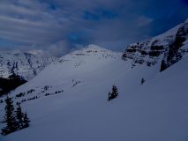
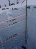
Aspect: West, North West
Elevation: 11,700′ to 12,100′
Avalanches:One small D1 on NE near treeline feature on Robinson bench terrain.
Weather: Cold day up high with calm to light winds. Air temp at 11:40 @ 11,800 -11. Around noon skies became overcast with a low ceiling and light snow but no real accumulation.
Snowpack: We headed for a NW slope off of Scarp Ridge to take a look at shaded alpine terrain features. We probe across a rolling NW facing terrain feature and found depths ranging from 100 to 215 cm with the average being somewhere around 160 or so cm. One profile in 190cm snowpack showed very rounded basal depth hoar (2 to 3mm) that was 1F hard bordering on 1F+. Midpack was generally 1f+ and pencil hard without out any concerning interfaces. Top 30cm was a bit more interesting with multiple 1f wind slabs with thin weak layers sandwiched between. ECTN results for these upper interfaces with failures present beneath shovel width only (no real slab present from the last week or two of wind and snowfall).
A second profile in a shallower area was likely more representative of snowpack structure on a slope scale outside of drifted areas. This site had an HS of 140 cm. Basal weak layers were also rounded but only at 4F hardness. Notable test results were CT23SC on basal weak layers at the Thanksgiving interface but ECTX. Upper snowpack again had several thin wind slabs with weaker snow between but not enough strong snow to produce propagating ECT results.
In this piece of NW terrain, basal weak layers look to be gaining strength verified with temp profile but the upper snowpack remained very cold with strong gradients helping to preserve sandwiched weak snow near the surface. It seemed like locations with significant drifting from the last round of snow could produce triggered avalanches if a more substantial slab was present over buried mid-December weak layers.
Photos:
Date: 12/28/2018
A low-pressure system is currently spinning across the four corners region this morning pushing moisture up from the south. Most of this moisture will not make it past the San Juan Mountains but you can expect a few inches of accumulations today in the Crested Butte area. Snowfall will likely be finished by tonight as the system pushes off to the east of Colorado. Saturday will be a dry day with cold temperatures. The next chance at precipitation will come on Sunday evening as a trough moves through the forecast area offering modest snowfall potential.
High Temperature: 10 to 15
Winds/Direction: 5 to 15, SE
Sky Cover: Mostly Cloudy
Irwin Snow: 0 to 2
Elkton Snow: 0 to 2
Friend’s Hut Snow: 0 to 2
Low Temperature: -3 to -8
Winds/Direction: 0 to 10, SW
Sky Cover: Mostly Cloudy
Irwin Snow: 0 to 2
Elkton Snow: 0 to 2
Friend’s Hut Snow: 0 to 2
High Temperature: 14 to 19
Winds/Direction: 3 to 13, WNW
Sky Cover: Partly Cloudy
Irwin Snow: 0
Elkton Snow: 0
Friend’s Hut Snow: 0
Location: Paradise Divide Area
Date of Observation: 12/27/2018
Name: Eric Murrow
Subject: P-Divide shaded treeline structure
Aspect: North East
Elevation: 11,500′
Avalanches: While driving to town in the morning noticed a fresh slab on Whetstone in Lucky Boy Basin area, released in apron below steeper bowl feature. ESE @ 11,900′.
Weather: Mostly clear with a few high clouds filtering through. Air temps were reasonable at -7c @ 1115am, winds were calm.
Snowpack: Dug a full profile on a near treeline shaded slope to take a look at basal weak layer and more recent developing “Santa Slab” in upper snowpack. Most notably test site produced moderate CT and ECTP results around the 12/19 interface (Santa Slab). This location had a thin, stiff wind deposited slab below the Christmas storm snow that was resting on buried near surface facets that developed from the dry period during the middle of December. Basal depth hoar continues to show signs of rounding but is still 2 to 3mm in size and 4F hardness. See image below.
Photos:


Location: Paradise Divide Area
Date of Observation: 12/27/2018
Name: Lawson Yow
Subject: SF Alpine Treasury, Cinnamon
Aspect: East, South East, South
Elevation: 12,500
Avalanches:
About a dozen recent, smallish slides from the ridgeline connecting Treasury and Galena. Since Monday storm.
Langer older slide one Cinnamon EF, prior to Monday storm.
Weather: Clear, not windy
Snowpack:
Photos:
Date: 12/27/2018
A closed low is to our south, unfortunately it looks like the San Juans will block a large majority of the precipitation from reaching this zone. Today will remain mostly clear with clouds increasing this evening. Our best shot at any new snow will be tonight through tomorrow morning with accumulations in the 1-2″ range. Day time temperatures will remain in the teens on average for the next two days with lows in the single digits at night. Winds should remain light with a slight shift tomorrow morning when winds will be out of the south east gusting into the teens. For the start of the weekend a small ridge develops while we wait for the next low off the pacific coast to arrive Sunday.
High Temperature: 20
Winds/Direction: 3-5,WSW
Sky Cover: Partly Cloudy
Irwin Snow: 0
Elkton Snow: 0
Friend’s Hut Snow: 0
Low Temperature: -1
Winds/Direction: 3-5, SE
Sky Cover: Overcast
Irwin Snow: 0-1
Elkton Snow: 0-1
Friend’s Hut Snow: 0-1
High Temperature: 18
Winds/Direction: 3-5, SE
Sky Cover: Mostly Cloudy
Irwin Snow: 0-1
Elkton Snow: 0-1
Friend’s Hut Snow: 0-1
Location: Kebler Pass Area
Date of Observation: 12/26/2018
Subject: Breaker breaker 1-9
Aspect: South East
Elevation: 9,600-11,000’
Avalanches:
Weather: Warm with intermittent high thin clouds and significant green-housing
Snowpack: PS structure present on sun-exposed slopes below treeline, but significantly more pronounced near treeline. Only direct sign of instability we saw was localized (~10m) full-depth collapse on SE aspect near our high point ~11,000’. Daytime warming produced breakable crust on sun-exposed slopes TL/BTL when the snow surface cooled ~3pm.
Photos:
Location: Crested Butte Area
Date of Observation: 12/26/2018
Name: Chris Martin
Subject: Coneys Island
Aspect: North, North East
Elevation: 9600′-10800′
Avalanches:
N/O
Weather: Partly Cloudy with a High of about 29F. Calm winds.
Snowpack: 8-10″ of new snow fell across the anthracite Mesa, snow remains a very soft slab(if at all) BTL and well below the ridge lines. Near coneys ridge above first bowl and trending into second bowl, Soft Snow lays over harder windslab. Slabs Present near ridge on lee aspects. Weak layers were observed within the new storm and blown snow near ridgleines on lee aspects between first bowl and second bowl zone of coneys’.
Persistent Slab Observed in the coneys zone, convex corner entrance, 70-80 cm from surface, about 20-25 cm of 2-3mm Depth Hoar.
Photos: