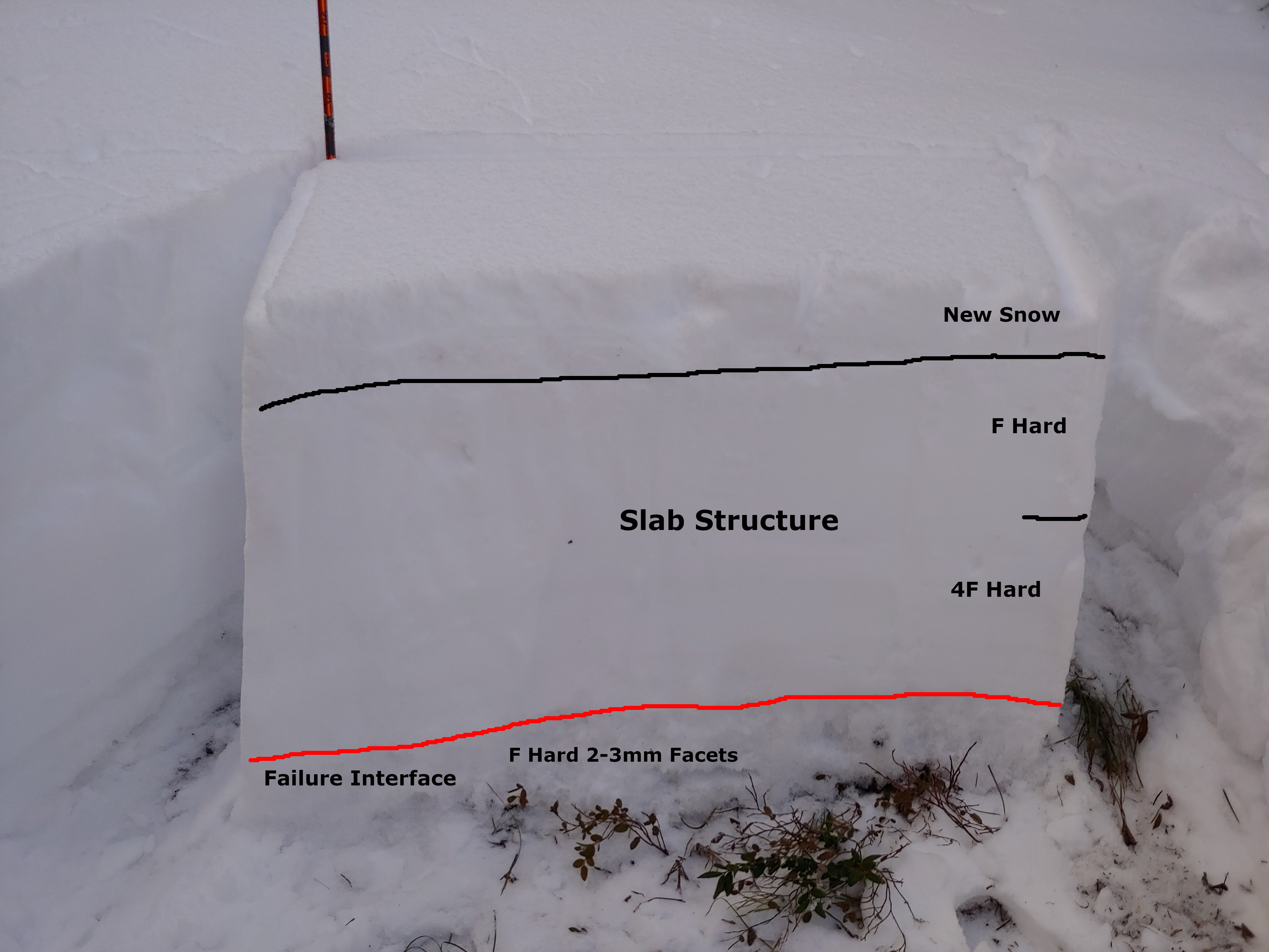
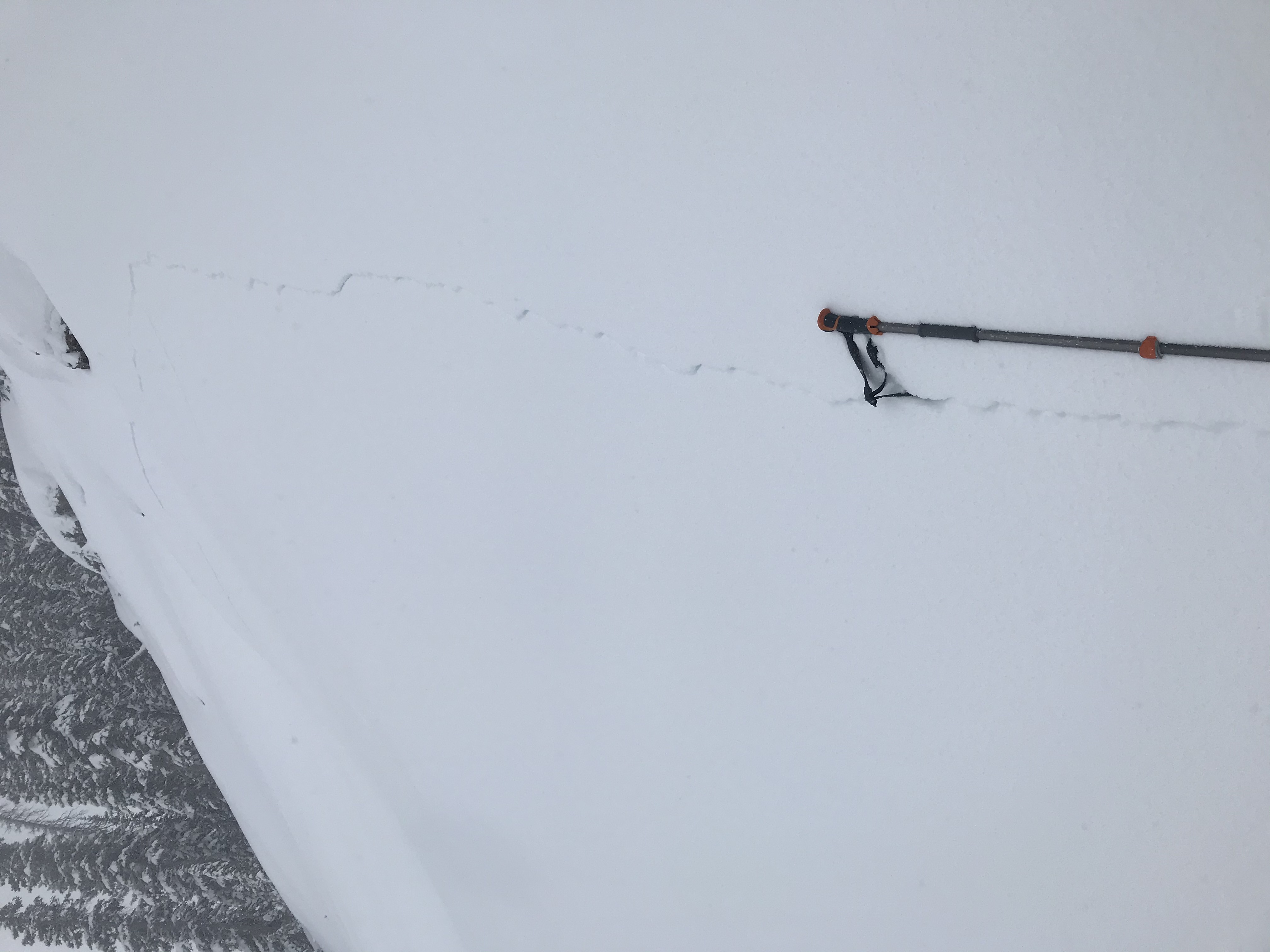
Mountain Weather for 11,000ft. Wednesday 12/11.

CB Avalanche CenterWeather

Date: 12/11/2019

Ok, I want to talk quickly about today so we can move on to the snow baby! This morning valley low temperatures are again below zero while 11,000ft temperatures are in the high teens. Wind-speeds have decreased overnight and look to stay down for today. Upper-level moisture starts increasing this afternoon and we’ll see that with increasing clouds. Enough of that? Let’s move onto the snow part.

Thursday afternoon into the Friday AM hours is looking good for the snow bits. Westerly flow will bring a moisture tap stretching out to Hawaii. That moisture is looking good at both 500mb and 700mb during the above timeframe. In my perfect world, it could drop a bit further south and stay more consistent, but never the less we’ll have the stuff snowflakes are made of. The atmosphere will further be unstable and we’ll have strong winds aloft. So we are shaping up good. To call a foot of snow for this time period may be a bit dreamy at the moment, but it should stack up never the less. Dryer air moves in later on Friday, then more snow looks to be in the forecast for Saturday!

  • Today

    High Temperature: 20 to 24
    Winds/Direction: 5 to 15, W
    Sky Cover: Increasing clouds
    Irwin Snow: 0
    Elkton Snow: 0
    Friend’s Hut Snow: 0

  • Tonight

    Low Temperature: 14 to 18
    Winds/Direction: 5 to 15, W
    Sky Cover: Mostly Cloudy
    Irwin Snow: 0 to 1
    Elkton Snow: 0 to 1
    Friend’s Hut Snow: 0 to 1

  • Tomorrow

    High Temperature: 24 to 28
    Winds/Direction: 10 to 20, W
    Sky Cover: Mostly Cloudy
    Irwin Snow: 0 to 2
    Elkton Snow: 0 to 2
    Friend’s Hut Snow: 0 to 2

West Brush Creek

CB Avalanche Center2019-20 Observations

Location: Brush Creek Area
Date of Observation: 12/10/2019
Name: Eric Murrow

Subject: West Brush Creek

Aspect: East, South, South West

Elevation: 9000′ to 11450′
Avalanches: Gothic: 2xSS-R1-D2 large avalanche on “spork” and east face
Baldy: 1xSS-R2-D2 large avalanche on an alpine east face

WSC: 2xSS-R2-D2 SE alpine terrain features

Weather: Clear skies, mild temperatures, and light winds in terrain traveled. No significant loading but occasional drifting at highest terrains near peaks,.

Snowpack: Traveled up onto Teo ridge from West Brush Creek looking at slab structure to the east of Crested Butte. Profile dug in an east-facing meadow at 11,200′ found HS 78cm with cohesive slab resting above old, weak facets at the ground. Test results CTV and ECTP16. This structure produced numerous rumbling collapses in nearby areas.  HS on south and southwest facing near and below treeline was around 40cm.  Southerly terrain produced collapses as well but not nearly as large as east-facing terrain.  Southerlies had a double crust with facets beneath.  South-facing slopes below treeline had become moist by the afternoon.  Poor looking structure in most terrain traveled.  HS at 9900′ in valley bottom below Teocalli was around 5ocm.

Coneys

CB Avalanche Center2019-20 Observations

Location: Paradise Divide Area
Date of Observation: 12/10/2019
Name: Sam Roberts

Subject: Coneys

Aspect: North, North East, East

Elevation: 9600′-10380′
Avalanches:

Saw a small point release slide in Coon Basin on Mount Emmons N aspect R1D1
On the way to Coneys we saw R1.5 D2 on the South side of Mount Baldy around 12000′

Weather: Sunny all day with little to no wind in the valley bottom. The morning started at around -18 degrees C and warmed up to -8 degrees C by the end of the tour. There was abundant westerly winds on the mountain tops with a lot snow transport. Snowpack: There is more snow out there but its still pretty scary. On the way out to Coneys there was widespread woompfing and cracking on the flats away from the skin track. Once we did the uphill into Cat’s Hat glades we dug a pit on a 29 degree slope facing NE-E at 10380′. We found a solid spot and found 66cm of snow where three layers were present, the new snow (10cm of F hard stellars), a large slab structure (top 20cm F hard rounded grains and the lower 20cm 4F hard rounded grains), and finally that lovely basal facet layer (16cm F hard 2-3mm facets). As we were setting up for an ECT, the column failed on isolation in a very sudden planar Q1 fracture on the basal facet/slab interface that propagated across the entire column (so ECTP 0?). Frightening results, so we stuck to lower angle terrain and ended up getting some pretty nice turns and no one got any core shots.

Photos:

Recent Natural Avalanches

CB Avalanche Center2019-20 Observations

Location: Kebler Pass Area
Date of Observation: 12/10/2019
Name: Evan Ross & Zach Kinler

Subject: Recent Natural Avalanches

Several fresh natural avalanches were observed on 12/10 thanks to the mostly clear sky and good light. Some of these avalanches looked very fresh and may have released during the AM hours of 12/10. Most avalanches in this natural cycle probably failed during the PM hours of 12/9 or the AM hours of 12/10.

Northeast:
4th Bowl on Axtell. A fresh large avalanche that failed at the ground and initiated on the cross-loaded portion of the bowl. The rest of the avalanche was obscured by the terrain in between.

East:
East Bowl in the Anthracites. A small Wind Slab looked to have released above the cliffs, it then fell onto the slope below and triggered a Persistent Slab failing on SH in the upper snowpack, which then collapsed the well-developed facets at the bottom of the snowpack releasing a larger Persistent Slab. All that also remotely triggered a Persistent Slab failing on the ground next to this avalanche. The avalanche debris had 3 to 5mm SH that had grown on them since the avalanche released.

Ruby/Owen Saddle. A large slab avalanche that appeared to have stepped down into old snow. Released in the last 24hr. SS-N-R1-D2-O

Red Coon Bowl. A Small Wind Slab released off the ridge and stepped slightly deeper into the snowpack releasing a small persistent Slab. SS-N-R1-D2-O

South East:
Afley Peak, ATL. A large slab 1-2ft deep and estimated to have broken into old snow. SS-N-R2-D2-O

3rd hand report: Skier triggered avalanche on Tree Chute in the Anthracites on 12/9. No specific information.

Mountain Weather for 11,000ft

CB Avalanche CenterWeather

Date: 12/10/2019

The clouds and lingering flurries have exited the area overnight with mostly clear skies expected today with light winds. A light inversion has set up overnight, under clearer skies, with valley bottoms pushing just below 0. The weather will be uneventful today and tomorrow. Late Wednesday a very weak disturbance will quickly pass over the area but will bring very little moisture and is not expected to produce much snowfall if any at all.
The next significant snow producers will begin to impact the area on late Thursday night. This system looks like it will establish a zonal flow for several days with the possibility of significant snow accumulations through the weekend. Stay tuned over the next couple of days as this system gets closer. It is looking like we will have a snowy weekend coming up.

  • Today

    High Temperature: 25 to 29
    Winds/Direction: 7 to 17, WNW
    Sky Cover: Clear
    Irwin Snow: 0
    Elkton Snow: 0
    Friend’s Hut Snow: 0

  • Tonight

    Low Temperature: 6 to 10
    Winds/Direction: 7 to 17, W
    Sky Cover: Mostly Clear
    Irwin Snow: 0
    Elkton Snow: 0
    Friend’s Hut Snow: 0

  • Tomorrow

    High Temperature: 24 to 28
    Winds/Direction: 5 to 15, WSW
    Sky Cover: Increasing clouds
    Irwin Snow: 0
    Elkton Snow: 0
    Friend’s Hut Snow: 0

Paradise Divide Storm check and Sunnies

CB Avalanche Center2019-20 Observations

Location: Paradise Divide Area
Date of Observation: 12/10/2019
Name: Eric Murrow

Subject: Paradise Divide Storm check and Sunnies
Aspect: East, South East, South, South West
Elevation: 9400′ – 11850′


Weather: Mostly cloudy skies with intermittent snowfall, accumulations during day up to 1 inch.  Light to moderate NW winds, some transport observed in alpine terrain.

Avalanches: Visibility was poor most of the day making avi obs difficult. Just one recent D1 slab failed on an east aspect of Baldy right at treeline, crown completely refilled with only debris visible. Maybe crust/facet combo was involved but it really looked more just like a Wind Slab.
Baldy: 1xSS-R1-D1, SE

Snowpack: Storm total at 10,900′, right near Elkton, was around 24cm with 1.1″SWE. Traveled on mostly southerly facing slopes investigating the development and spread of the Persistent Slab avalanche problem. HS across this terrain was around 50cm to 70cm. Below treeline south and southeast aspects are not of much concern, two crusts were present but the lowest was on the ground and the upper one was buried 12/5 with little faceting beneath at this point (just a thin soft slab resting above from latest round of snow). Near treeline, the lowest crust was 6 to 8 inches above the ground with 1.5-2mm facets beneath. But very little snow volume above, no real slab except maybe for the most drifted locations at upper elevations. Near and above treeline locations do have a weak crust/facet structure near ground and could develop a Persistent Slab problem once a slab forms above. See photos for view of BTL and NTL SE structure.

Photos:

Great skiing on SW

CB Avalanche Center2019-20 Observations

Location: Paradise Divide Area
Date of Observation: 12/09/2019
Name: Evan Ross

Subject: Great skiing on SW
Aspect: South, South West, West
Elevation: 9,700-11,900

Avalanches: Couple little Loose Snow Avalanches about. Most notable recent avalanche is covered in Eric’s observation. At mid to low elevations, along Climax area to Schuylkill, to Purple Palace, I didn’t observe any new or recent avalanches. You can still see old crowns from the 11/30 natural cycle and the Pittsburgh skier triggered avalanche on 12/5.

Weather: Partly Cloudy. Several snow showers adding up to maybe an inch for the day. Light to Moderate west to northwest winds, with moderate snow transport above treeline.

Snowpack: Total new snow accumulations were sitting around 8″. Skiing conditions were great. Steep south facing slopes had a crust just under the new snow, while SW to W facing slopes made for the best turns and didn’t have this same crust. Only one collapse and shooting crack observed on this tour. This occurred when crossing a tight and shaded gully that held old weak snow. Otherwise quiet for obvious signs to instability.

Cement Creek storm total

CB Avalanche Center2019-20 Observations

Location: Cement Creek Area
Date of Observation: 12/08/2019
Name: Cosmo

Subject: Cement Creek storm total
Aspect:
Elevation: 9400

Avalanches:
Weather: 9” new snow from Sunday storm, Cement Creek @ 9400’
Snowpack:

Photos:

Mountain Weather for 11,000ft

CB Avalanche CenterWeather

Date: 12/09/2019

Yesterday’s storm has shifted eastward leaving the area under a WNW flow. This flow will keep some cloud cover and a few flakes falling to the north and west of Crested Butte, but areas close to town and to the east will have clearer skies. Temperatures will remain comfortable even under northwest flow. As the day progresses, skies will continue to clear and a ridge of high pressure will build into Tuesday leaving us with drier weather through Thursday. The next snowmaker looks to arrive close to the weekend.

  • Today

    High Temperature: 21 to 25
    Winds/Direction: 10 to 20, NW
    Sky Cover: Mostly Cloudy
    Irwin Snow: 0 to 1
    Elkton Snow: 0 to 1
    Friend’s Hut Snow: 0 to 1

  • Tonight

    Low Temperature: 1 to 5
    Winds/Direction: 10 to 20, NW
    Sky Cover: Mostly Clear
    Irwin Snow: 0
    Elkton Snow: 0
    Friend’s Hut Snow: 0

  • Tomorrow

    High Temperature: 25 to 30
    Winds/Direction: 7 to 17, WNW
    Sky Cover: Clear
    Irwin Snow: 0
    Elkton Snow: 0
    Friend’s Hut Snow: 0

AMR Buried Surface Hoar

CB Avalanche Center2019-20 Observations

Location: Kebler Pass Area
Date of Observation: 12/08/2019
Name: Joey Carpenter

Subject: AMR Buried Surface Hoar
Aspect: North, North East
Elevation: 10200-11400

Avalanches:

None observed.

Weather: 9a-230p at the Anthracites. Snowfall rates varied from NO snow to S5 rates for brief periods. Overnight plus daytime accumulation totaled at ~13cm. It was still snowing hard when we left. Snow type and quality shifted from stellars, to graupel, to fat “wet” flakes, back to graupel, back to fatties through the day. OVC skies broke at times for periods of 6/8 cloud coverage making for beautiful light. Mostly no wind with brief periods of light but shifty in direction, predominantly NW. These periods of wind came with light snow transport at the NTL elevations we traveled in.
Snowpack: We experienced a very talkative snowpack today with too many small to medium collapses to count. Most notably was when venturing off the skin track at 10.7k on a sheltered but open NE slope. We experienced a medium sized collapse and watched cracks propagate in steeper adjacent terrain 100+ feet away. Cracks propagated ~150 feet across the steeper 33 degree slope but the slab did not run. We approached the most prominent crack (see photo, ski pole for reference) and dug down to find the failure point (second photo, crack left of probe). The denser snow from the last two storms has formed an approximately 30cm slab resting atop fragile surface hoar. I was able to pull several grains out (see photos). Overall depth in this area averaged ~100cm. The snowpack consisted of 40cm of fist hard facets near the ground from October, 27 cm of 4f slab from around thanksgiving, ~2cm of buried surface hoar and 30 cm of new snow from the last week.

We also saw multiple shooting cracks propagating shorter distances in BTL terrain from ski tips on slopes barely reaching 30 degrees. This sensitive weak layer, where it can be found is very reactive under minimal load.

Photos: