Observations

03/30/21

Don’t forget the sunscreen

Date of Observation: 03/30/2021
Name: Jack Caprio, Eric Murrow

Zone: Northwest Mountains
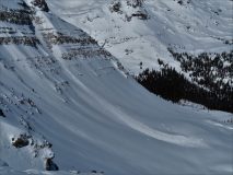
Location: Kebler Corridor
Aspect: North, North East, East, South East, South
Elevation: 9,500′-12,000′

Avalanches: No new avalanches observed

Weather:  Sky cover became partly cloudy in the morning with lots of sunshine by noon. Light northerly winds with moderate gusts. Warm temperatures near and below treeline out of the wind.

Snowpack:

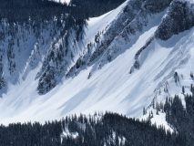
We targeted wind-loaded slopes up to 12k in search of wind slab and persistent slab problems.  Recent wind-drifting in this area did not create much Wind Slab formation. We did step into steep N-facing, slightly wind-loaded alpine terrain. Near ridgeline, N/ NW wind events throughout the season had made the snowpack very shallow. The first 50 vertical feet down consisted of a very shallow mix of facets and thin windboard layers. After about 50 vertical feet the snowpack became deep and uniform again and we saw no signs of instability.

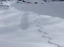
We briefly ascended a southeast-facing slope near treeline without much previous drifting and found HS between 70 and 100cm with a moist surface crust just supportive enough to carry skis, but not boots.  The snowpack below was weak isothermal snow to the ground without any slab.

Read Full Observation
03/28/21

Ripe Cornice

Date of Observation: 03/27/2021

Zone: Northwest Mountains
Location: West Elks
Aspect: South East, South
Elevation: 12,000′

Avalanches: Other than some smaller sheds of recent snow attributed to solar warming below rock bands and such, no recent notable avalanches observed. While traversing the ridge to access our ski line, my partner put a left ski just a little to far out on a big cornice and punched through far enough to trigger a school bus-sized cornice fall. The ridge is very sharp (knife ridge) in this particular spot and his right ski didn’t leave bare rock on the windward side of the cornice when it failed. Fortunately, my buddy was in a safe enough location to not take a ride, but it was certainly a sobering reminder to give every cornice it’s due respect and always ensure you are in a safe place when negotiating the beast. It was a big cornice failure and entrained localized snow on it’s descent, however, it didn’t propogate much beyond the immediate path. Probably ran around 1000′. This cornice, as I assume most are currently, was primed and ready to go. The pictures come from my flip phone, so I apologize for the poor quality.
Weather: Ridge winds were moderate from the North. Pretty pleasant on the climb to the ridge. Lots of sun.


Photos:

Read Full Observation
03/28/21

Sprang break

Date of Observation: 03/28/2021
Name: Zach Guy

Zone: Northwest Mountains
Location: Ruby Range
Aspect: North, North East
Elevation: 9,000 – 12,100′

Avalanches: 2 recent cornice falls. One on Garfield Peak plowed to the ground in a steep, rocky feature (D1.5), one on Owen triggered several layers of slab avalanches and ran impressively far (D2).
Dozens of small wet loose avalanches from yesterday, generally D1. Wet activity continued today.
Weather: Light winds this morning, some moderate gusts midday. Clear skies and warm temperatures.
Snowpack: Wet loose activity: below treeline east and a few northeast aspects were active today, south aspects are transitioning to stable corn snow. Near and above treeline, activity continued on east, southeast, and south aspects. We finished the tour before westerly aspects warmed up.
We rode steep north and northeast facing terrain with no signs of instability, these slopes were either scoured or protected from yesterday’s northerly winds. There was a northwest facing slope that we avoided after probing revealed a poor structure (~2′ -3′ slab over weak facets). Based on debris evidence, it looked like this slope had avalanched earlier in the year.


Photos:

Read Full Observation
03/27/21

Here comes the sun

Date of Observation: 03/27/2021
Name: Jack Caprio Zach Guy

Zone: Northwest Mountains
Location: Kebler Pass
Aspect: North, North East, East, West, North West
Elevation: 9,400-12,500

Avalanches: 1 intentionally ski-triggered wind slab avalanche on heavily loaded east-facing test slope above treeline. The crown ranged from 6-24 inches. The larger part of the crown (2 ft) was the trigger point. This was the most windloaded area on the slope. The crown pulled back about a foot above the skier but the skier was able to easily ski out of it because the slope was small.  A couple of other small slabs in the area that released in the past 12 hours or so from wind effect.

15-20 small loose wet avalanches on sunny near and above treeline terrain. The near treeline elevation band had a more widespread avalanche cycle due to continued winds and cloud cover above treeline helping keep surfaces cooler and denser.
Weather: Few to scattered skies throughout the morning. Clouds cleared around 3pm as the solar intensity increased. Moderate northwest winds with strong gusts.
Snowpack: Recent storm snow consisted of about 10-12 inches earlier in the day. This new storm snow rapidly settled to about 8 inches on E and W aspects as the snow moistened.  Numerous rollerballs and pinwheels observed.  The snow stayed dry on steep north aspects.

Above treeline, NW and W winds continued to deposit snow onto leeward ridgelines. In the alpine, we chose to stick to terrain that had not previously avalanched during the February cycles. Very small wind slab pockets were our only signs of instability on alpine N-facing terrain.


Photos:


Read Full Observation
03/27/21

Avalanches in Ruby Range

Date of Observation: 03/27/2021
Name: Evan Ross and Zach Guy

Zone: Northwest Mountains
Location: Ruby Range

Avalanches: See photos and captions. A handful of slab avalanches, D1 to D2 that ran in the last day or two. These appeared to generally involve just the new and windblown snow from the past few days, or wet sluffs today. One on the NE face of OBJ was thick enough it might have broken into older layers, although it was too far away to say anything with confidence.

Photos:

Read Full Observation
03/26/21

Weekly Snowpack, Weather, and Avalanche Summary 3/26/21

Date: 03/26/2021

Name: Jack Caprio

Zone: Crested Butte Backcountry


Consistent moisture throughout the week rewarded us with many pow days in the snow-favored areas of the zone. Check out the weekly summary to see how these storms impacted avalanche conditions.

Read Full Observation
03/24/21

Washington Gulch obs

Date of Observation: 03/24/2021
Name: Eric Murrow


Zone: Northwest Mountains
Location: Washington Gulch – obs from near TH to treeline on Baldy
Aspect: North, North East, East, South East, South, South West, West, North West
Elevation: 9,400 – 11,900′


Avalanches: Good views midday showed no recent avalanche activity.
Weather: Partly cloudy skies, with a good amount of sunshine in this area. Snow showers developed in areas east and west of Elkton, but no snowfall from 1130 – 430. Some thunder was heard from nearby convective cells. Maybe an inch or so of new overnight in this area. Winds were variable and light – very little blowing snow observed at upper elevations.
Snowpack: Covered a lot of ground on the snowmachine looking at sunny slopes. Most sunny terrain SE-S-SW had moist to wet surface snow sitting on older, well-developed melt/freeze crusts. On these sunny slopes, I anticipate the incoming storm system to fall on supportive crusts without much concern for developing a Persistent Slab problem. Shoulder aspects, east and west, had a few inches of dry snow resting on soft/melf freeze crust with additional soft crusts in the upper snowpack.

Shaded slopes facing very close to due north remain dry without crusts present, but as soon as you tilt eastward crusts show up below the snowfall since Saturday night. There are two layers of interest in the upper snowpack on shaded slopes, the upper being a melt/freeze crust with 1mm facets below and the other the mid-march weak layer with 1-1.5mm facets. At one near treeline site facing northeast, HS 155, I got moderate propagating results on the mid-march weak layer. Test results grabbed my attention – triggered avalanches are possible in the upper snowpack with a similar structure.

Closer to Washington Gulch TH I checkout a north slope with a much shallower snowpack, closer to 90cm, and found a fairly weak snowpack. Just an inch or two of recent snow sits on a soft melt/freeze crust with very weak 1-2mm facets below. A poor-looking structure for future loading events.


Photos:

Read Full Observation
03/24/21

Trickle of new snow

Date of Observation: 03/24/2021
Name: Eric Murrow


Zone: Northwest Mountains
Location: Kebler Pass Corridor
Aspect: North, North East, East
Elevation: Below treeline


Avalanches: no, recent avalanches observed. Spotted one old crown on SE aspect below treeline in Elk Basin.
Weather: Mostly cloudy skies with light snowfall throughout the day. Around 1 – 2 inches by morning with an additional inch during the day. Light winds below treeline.
Snowpack: Traveled across a number of east and northeast slopes below treeline that previously avalanched in early February. Around 90cm of settled snow has accumulated on bed surfaces with HS around 125cm in top of the start zone. No concerning test results found (ECTN 12 on mid-March facet/crust interface down 40cm). On an east aspect found ice columns have formed from previously meltwater draining through much of the snowpack, but still short of reaching the ground. Below 10,500 feet only the shadiest, north aspects remained dry below recent snow. Sunnier shoulder aspects have a variety of soft crusts near the surface from multiple small snows over the past week.  Dust layer observed down around 6 – 8 inches in this area.


Read Full Observation
03/22/21

Poverty Gulch

Date of Observation: 03/22/2021
Name: Evan Ross

Zone: Northwest Mountains
Location:
Aspect: North East, East, South East
Elevation: 9,500-11,500

Avalanches: No slab avalanches observed. Small debris piles from loose snow avalanches.

Weather: Clear sky in the morning, became mostly cloudy in the afternoon with periods of sun or poor vis and convective snow showers. The average calm or light winds would get a bit more gusty during the stormy periods and I’d assume they were stronger at ridgeline. Our skin track did refill between laps.

Snowpack: Last weekend’s interface was around 30cm’s deep. Given the amount of recent and now well settled snow, we found ourselves initially managing for wider spread storm slabs and more specific wind slabs. That recent snow was resting on crusts on the easterly slopes and softer or lightly fasted snow on the more shaded aspects. In the end neither avalanche problem appeared to be reactive and the past sluffs around the area also were not pulling out slabs. While confidence in the snowpack improved throughout the day, we were not about to let our guard down for the potential of an avalanche in the upper snowpack. Todays colder temps helped keep the ski quality high.

Read Full Observation
03/22/21

Bedsurface obs

Date of Observation: 03/22/2021
Name: Zach Guy

Zone: Northwest Mountains
Location: Lower Slate
Aspect: North East, East
Elevation: 9,000 to 11,400′

Avalanches: A few small loose avalanches ran today on higher elevation terrain in the Ruby Range from solar warming (dry and wet loose).
Weather: Mostly sunny mid-morning with clouds building midday. A few very light snow showers without any accumulating snow. Light northwest winds.
Snowpack: Tested the flanks of a few bed surfaces near and below treeline to see how they were holding up after the last round of snowfall (About 3″ to 6″ of settled storm snow here). A few ski cuts and column tests on paths that ran in mid-February did not produce any unstable results. In general, the structure is poor (1.5 mm, fist hard facets are buried about 40 cm), but it seems there’s not quite enough slab here to be reactive yet. The same structure would be quite a bit scarier if the slab was denser or thicker from wind effects. There are a few thin crusts near the surface on more easterly tilts adding some integrity to the equation as well.
Snow surfaces got slightly moist today on easterly and even some northeast tilts.


Photos:

Read Full Observation
The blog.