Scarp Ridge, Elk Basin, Redwell, Red Lady Bowl

CB Avalanche Center2020-21 Observations

Date of Observation: 03/22/2021
Name: Ian Havlick


Zone: Southeast Mountains
Location: Scarp ridge/Indy Basin/Elk Basin/Mount Emmons
Aspect: North, North East, East, South East, South, South West, West
Elevation: 9000-12,400


Avalanches: No avalanches observed except for an older crown line in NW facing ATL Peeler Basin off Scarp Ridge
Weather: Mostly clear skies gave way to mostly cloudy and poor visibility due to convective S1-S2 snow showers. heavily rimed snowfall, 1/2″ accumulation during these showers.
Snowpack: Snowpack was mostly quiet, mix of 2-6″ new snow over the last 48hrs resting on mix of crusts, windbuff and small grained facets. Some minimal windloading on south facing ridgelines from early morning northerly winds. No signs of instability across variety of aspects. No significant windslab development.


Bedsurface obs

CBAC2020-21 Observations

Date of Observation: 03/22/2021
Name: Zach Guy

Zone: Northwest Mountains
Location: Lower Slate
Aspect: North East, East
Elevation: 9,000 to 11,400′

Avalanches: A few small loose avalanches ran today on higher elevation terrain in the Ruby Range from solar warming (dry and wet loose).
Weather: Mostly sunny mid-morning with clouds building midday. A few very light snow showers without any accumulating snow. Light northwest winds.
Snowpack: Tested the flanks of a few bed surfaces near and below treeline to see how they were holding up after the last round of snowfall (About 3″ to 6″ of settled storm snow here). A few ski cuts and column tests on paths that ran in mid-February did not produce any unstable results. In general, the structure is poor (1.5 mm, fist hard facets are buried about 40 cm), but it seems there’s not quite enough slab here to be reactive yet. The same structure would be quite a bit scarier if the slab was denser or thicker from wind effects. There are a few thin crusts near the surface on more easterly tilts adding some integrity to the equation as well.
Snow surfaces got slightly moist today on easterly and even some northeast tilts.


Photos:

Fresh Cream

CBAC2020-21 Observations

Date of Observation: 03/21/2021
Name: Evan Ross

Zone: Northwest Mountains
Location: Upper Slate River
Aspect: North East, East, South East
Elevation: 9,000-12,000

Avalanches: Good visibility in the afternoon lead to only one slab avalanche observation. Fresh small wind slab on Augusta’s SE face at 12,500ft. Below treeline near 10,200ft, we hung out near a very steep NE slope that had a quick shed cycle from the warm temps and a period of sun. These were small in size. Several other small loose snow avalanches were noted from the sun or warm temps.

Weather: Snowfall ramped up after sunrise through the mid-day. Several pulses of heavy snow, interspersed with breaks in the clouds and strong solar. The greatest 24hr snow total measured was on a protected northerly slope at 10,400 feet, HN 25cm. Down in the valley, it was closer to 15cm, but the warm low elevation temps and/or the bursts of sunshine were rapidly settling the new snow at other locations. Hung out at rideline for about an hour and the winds were mostly light. Snow plumes could be seen at times on the high peaks.

Snowpack: The snow really started to add up this morning while the Ruby Range was producing. The low elevation shed cycle in the morning kept us from choosing to travel up a huge terrain trap, but otherwise, those were small loose snow avalanches. We later traveled up a steep below treeline NE slope that had previously avalanched in February and didn’t find any obvious signs of instability. HS above the crown was 195cm, and HS below the crown was 150cm. Gaining a ridgeline around 11,700ft, we found fresh wind drifts about 30 to 40cm’s thick, but they appeared to taper off quickly going into the easterly slope. We couldn’t get any results pushing snow down and the resulting sluffs showed that drifts tapered quickly. We were a little selective where we chose to ski into the above treeline terrain.

Skier Triggered Wind Slab

CB Avalanche Center2020-21 Observations

Date of Observation: 03/21/2021

Zone: Northwest Mountains
Location: Peeler Basin
Aspect: North, North East
Elevation: 12,100’

Avalanches: Skier triggered (D2?) wind slab off ridgeline ATL on northeast aspect. Obvious convex rollover and poor terrain selection. Crown approx 2’ and stepped down mid-slope to 3/10 layer. Skier was not caught and able to ski out but pretty spicy!
Weather: Mixed snow and sun. Maybe accumulated 1-2” during the day. Very calm wind.
Snowpack: 6-8” new above 11k. Seemed generally non-wind affected until obvious loading on ridgeline. Solar aspects became very moist with each sun pop throughout the day.


Photos:

Dirty Huckin

CBAC2020-21 Observations

Date of Observation: 03/21/2021
Name: Zach Guy

Zone: Northwest Mountains
Location: Peeler Basin
Aspect: North
Elevation: 9500’ to 12,000’

Avalanches: On above treeline, northerly aspects: Ski cut a small wind slab (12” thick) in a steep gulley below a cornice. Unintentionally triggered a small persistent slab (~18” soft slab broke on facets) after hucking a cliff band. The crown broke along the base of the cliff. This was in steep, rocky terrain where the total snowdepth was about 2 feet deep due to previous slides. Also several small natural loose dry avalanches ran today.
Weather: Mostly cloudy with pulses of light snowfall mixed with brief windows of sunshine. Light ridgetop winds with light transport out of the southwest.
Snowpack: 3” to 4” new snow, appeared to bond better to meltfreeze crusts (on E, S aspects) as opposed to dry snow on northerly aspects. Isolated drifts below alpine ridgelines up to 12”, with mixed results from ski cuts. No signs of instability near and below treeline.


Photos:

Anthracite Mesa-Coneys

CB Avalanche Center2020-21 Observations

Date of Observation: 03/21/2021
Name: Andrew Breibart

Zone: Southeast Mountains
Location: Coneys
Aspect: North East, East
Elevation: BTL

Avalanches: NA-poor visbility.
Weather: Mostly calm winds on the tour with light winds on the ridge line. Skies were obscured and snowfall rate was S1/S2.
On the skin out skies were obstructed with scattered S-1 snowfall. Winds picked up and were light with moderate gusts in the valley bottom.
Snowpack: Less than 3 inches of new snow in the skin track in the morning. On the leeward side of Convex Corner, snow depth was 5 inches. In the valley bottom, snow was not supportive on upper melt freeze crust. Snow in First Bowl was supportive. Triggered a shallow slough in the new snow that traveled on top of the upper melt freeze crust at the entrance to the bowl. The slough had little energy and may have traveled 25 feet.
The skin track on the exit had a trace of new snow.


Large natural, repeat offender on Cement

CB Avalanche Center2020-21 Observations

Date of Observation: 03/20/2021
Name: Zach Guy

Zone: Southeast Mountains
Location: North bowl of Cement
Aspect: North
Elevation: 12,000

Avalanches: Large natural persistent slab avalanche ran sometime after Friday at 2 pm. First observed on Saturday from a distance on Star Pass. This path ran back in February. Given the aspect and elevation, this was likely a dry slab that was triggered by surface warming.
 

Photos:

Wash Gulch

CB Avalanche Center2020-21 Observations

Date of Observation: 03/20/2021
Name: Cam Smith

Zone: Southeast Mountains
Location:
Aspect: South, West
Elevation:

Avalanches: 1x Wet slab on a W facing BTL slope that seemed to gouge to the ground and ran a surprising distance down a gulley. Maybe 100 ft. wide and ran ~1,000 ft. I like to think it was animal triggered based on the tracks going in then tracks coming out in a lower spot. But that might just be me believing what I want to believe for the sake of drama. (CBAC Note: Comparing some old observations this looks like the crown of an old avalanche reported in February that has a more melted out and wet appearance now. Guess it needs to snow more…)

Weather: Wasn’t the scorcher we expected in the morning

Snowpack: Crusts weren’t quite frozen solid on some lower angle slopes and places with any hint of shade. Loose wet activity on S and W faces of Gothic above treeline. If you dig skiing bulletproof crusts let me know I have all kinds of secrets for finding the least pleasant conditions.

Photos:

Gothic Highest Temperature Of The Year

CBAC2020-21 Observations

Date of Observation: 03/19/2021
Name: billy barr

Zone: Southeast Mountains
Location: Gothic

Weather: Not much up but today was the warmest so far this year st 48F and the first day the snow really started to melt on flat ground. Attached is a shot of wet, loose slides between Mt Bellview and the beginning of Rustler’s Gulch. And today is the first day the Robins are here.

Refilled Bed Surface

CBAC2020-21 Observations

Date of Observation: 03/19/2021
Name: Evan Ross

Zone: Southeast Mountains
Location: Carbon
Aspect: North, North East
Elevation: 9,000-12,000ft

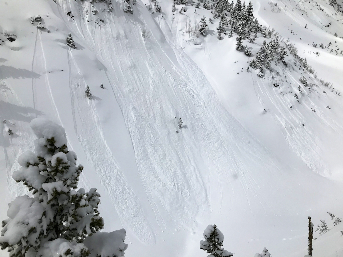
Avalanches: More small loose wet avalanches were noted. All small in size. Still lots of terrain that hasn’t shed, if it is going to shed…

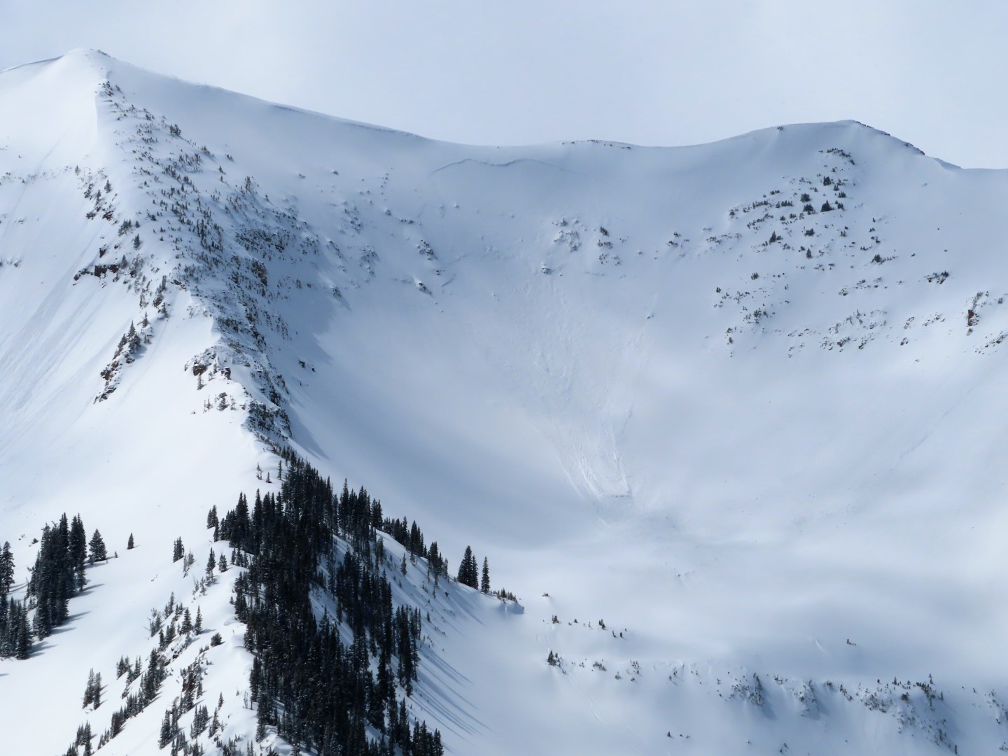
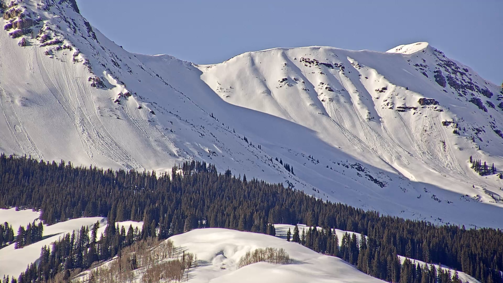
Observed 2 other new and notable slab avalanches. They both released since the last round of snow and look reasonably sharp or fresh. These were both viewed from far away so more specific details would just make for a poor estimate. Both failed on NE facing slopes between 11,700ft and 12,000ft. The avalanche on Ohio Peak looked more like a D1.5 while the avalanche out int he West Elks was a D2.

Weather: Some high clouds moved in for part of the mid day, otherwise mostly clear sky. Light winds at ridgeline. HOT. Elkton 11,100ft 49 degrees, CBMR 11,300 39 degrees.

Snowpack: Headed over to some north-facing terrain on Carbon that had previously avalanched back on February 6th. At 10,500ft the average HS was 155cm’s in undisturbed areas. I chose to target a small section of slope in the area where you could still see one of the old crowns running through the slope. North at 10,900ft. Here the HS dropped to right around 100cm. About 40cm’s down there was an obvious interface of fist hard weak facets. On top of those facets was a F to 1F slab. The most recent storm made up the upper 20cm of that slab. As I continued to dig the slope collapsed on those facets and I got the privilege of watching that collapse run through the pit. Stability text complete. Packed up and didn’t overstay my welcome any longer.

The 3/10 interface was under about 20cm of snow at this location. Currently, there didn’t appear to be a notable issue at that interface. So the layer of concern would be on slopes that previously avalanched and have now refilled with enough snow to form a new slab. The warm temps are of course further settling the upper snowpack and low angled northerly facing slopes had a moist snow surface.