Who’s got the wax?

CBAC2020-21 Observations

Date of Observation: 03/12/2021
Name: Zach Kinler, Zach Guy, Jared Berman, Jack Caprio
Zone: Southeast Mountains
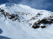
Aspect: North East, East, South East, South
Elevation: 8,800-12,200

Avalanches: 1 small windslab on a northeasterly alpine feature.

Weather: Mostly sunny, calm winds in sheltered terrain below treeline with moderate to strong winds on ridgleline. Generally warm temps with freezing level near 11K.

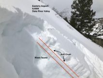
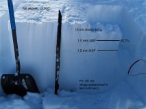
Snowpack: Thin and weak below treeline with dry snow on the northern half of the compass with moist snow and softening crusts on the southerlies. Due south at lower elevations was a thick fully supportable crust. This crust became soft and thin as you moved towards East and on a NE aspect just below 11k there was no crust present. This location had previously avalanched and was only harboring 60 cm of all weak and faceted snow. The 3/10 interface(1-1.5 mm NSF) is buried about 20cm below the surface and quite weak.

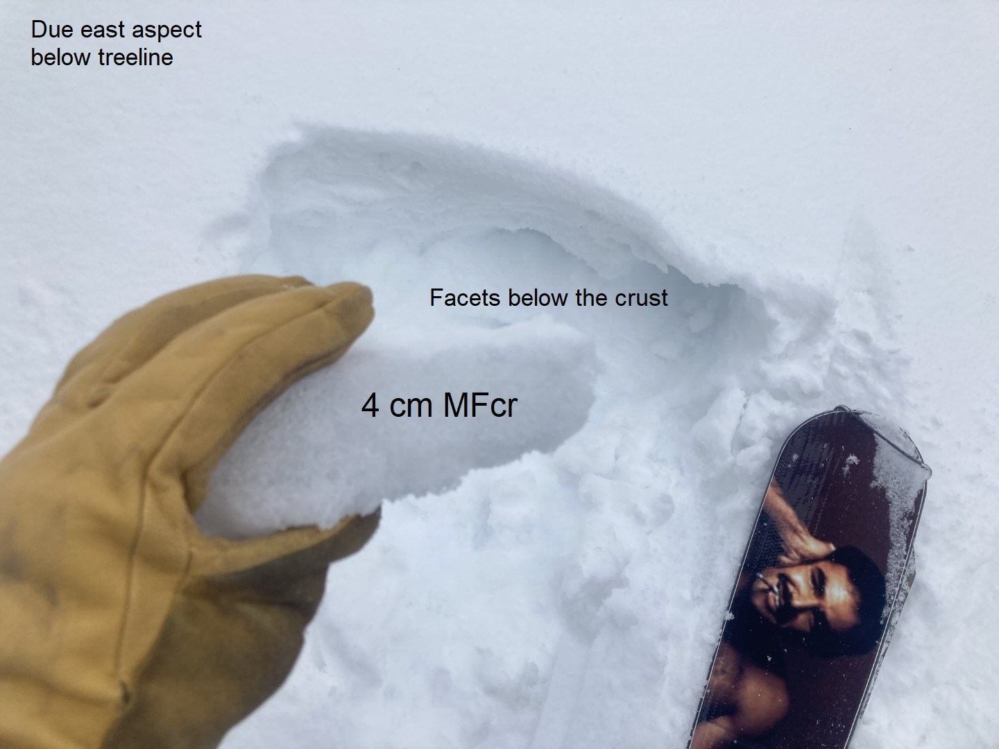
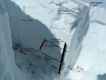
Moving up in elevation to just below 12,000 we targeted an easterly aspect focusing on the deeper weak layers from December and January. The December weak layer was Fist hard, 4 mm dry Depth Hoar with little to no rounding occurring. Long column results on this layer were ECTX with a PST 40/100 END down 100 cm indicating this layer is currently unreactive but still holding the potential to propagate a failure. Identical results were observed on the 1/19 layer(down 75 cm) at this location.

Winds were blasting and swirling snow more than building slabs, other than isolated and small pockets.


[/gravityforms]

March weak layer

CB Avalanche Center2020-21 Observations

Date of Observation: 03/11/2021
Name: Jack Caprio, Evan Ross, Zach Kinler
Zone: Northwest Mountains

Location: Skooks
Aspect: North, North East, East
Elevation: 9,000-11,400

Avalanches: No new avalanches observed.
Near ridge line, we initiated collapses along with radiating cracks on recently loaded NE to E facing start zones.

Weather: Broken skies for most of the day. Periods of S-1 snowfall. Light winds.

Snowpack: We went hunting for information on our recently buried March weak layer ahead of this weekends storm. Below tree line, the weak layer is buried by 4” of recent snow. On easterly facing slopes around 9.5k, the interface consisted of a soft 2” thick MF crust resting on top of 1-2 mm facets. Quick shovel shear tests at this site produced easy failure results just below the crust. As the compass tilted north-east the crust became softer and weaker. On due north slopes the interface consisted of 1-2 mm near-surface facets. As we gained elevation we continued trying shovel shear tests that produced failure both above and below the crust. We saw some cracking and got a couple collapses on leeward slopes just below ridgeline where 12″ or more of new snow had drifted over the weak new/old interface.

We also tested the 12/10 interface at a deeper, near tree line site. At this site, the 12/10 interface was buried 110 cms below the surface and consisted of 4F 2-4 mm DH. A pencil hard 110 cm slab is resting on top of this interface at this location.  A PST test resulted in unlikely propagating results (80/110 END down 110 cm). The 12/10 depth hoar was moist and seemed to be showing signs of rounding and sintering.

Shallow pockets

CBAC2020-21 Observations

Date of Observation: 03/11/2021
Name: Zach Guy

Zone: Southeast Mountains
Aspect: North East, East
Elevation: BTL

Avalanches: On a NE aspect BTL, I skier triggered a couple of shallow soft slabs breaking on the recently buried near-surface facets, that then plowed deeper into the weak snowpack. 6″ thick, D1 in size, ran a few hundred feet.
Snowpack: Quick tour to hone in on the distribution of persistent weak layers below treeline near town before the upcoming storm. Generally, anywhere that the current conditions are soft (northeast aspects), there are .5mm to 1.0 mm facets below recent snow and in some cases, thin soft crusts. The crusts become thicker and should handle more of a load on due east or anything south of that. The transition from good to bad happens around ENE.


Photos:

Small Soft Slab Avalanche

CBAC2020-21 Observations

Date of Observation: 03/10/2021
Name: Kinler, Caprio, Ross

Zone: Northwest Mountains
Location: Kebler Pass
Aspect: North East, East
Elevation: 9,500ft to 11,900ft

Avalanches: Remotely triggered one small soft slab from about 10 feet away. Crown estimated to have averaged about 8″ thick, failing in faceted snow between a pair of soft crusts. Steep East aspect 11,600ft. While small in size, this avalanche ran about 1,200 feet through steep terrain. Skier triggered a couple small loose snow avalanches that were mostly stubborn to trigger on steep northerly facing slopes below treeline.

Weather: Snowfall tapered off for most of the day, before starting to pick back up again around 5pm. Mostly light to moderate winds were we traveled. Clearly stronger winds at higher elevations and plumes of some of the high peaks.

Snowpack: We mostly traveled on northerly facing slopes below treeline. At valley bottom,HST at 4:30 was 5″ settled with .45″ SWE(9% density) Here, the new snow was a bit thick. Loose snow avalanches where the main concern, though they were a bit stubborn to trigger on steep 40 degree slopes. A couple interfaces of small facets were observable in the upper 20cm’s of the snowpack. Something to keep an eye on down the road.

Coney’s lap

CBAC2020-21 Observations

Date of Observation: 03/10/2021
Name: Eric Murrow


Zone: Southeast Mountains
Location: Coney’s
Aspect: North East, East
Elevation: 9,500 – 10,900′


Avalanches: While on tour visibility obscured nearby terrain. Took a pavement tour later in the afternoon during a clear period and was able to gaze at many drifted features around the area and was not able to spot any fresh activity.
Weather: Mostly cloudy skies from 930 to 1230. Very light snow without any real accumulation during this period. Moderate westerly winds at ridgetop with some transport observed.
Snowpack: Measured 6″ new w/ .45″ SWE at 10,700 feet (noon). East slope at snow measurement site had 3-4cm melt/freeze crust (not quite supportive to skis) underneath new snow with ice columns present around 30cm down from crust. While walking ridgeline I produced two moderate collapses on wind drift/lip that produced shooting cracks up to 50 feet – cracks only ran through drift and not into steeper, less drifted terrain below. Drifts were on sub 30 degree terrain so did not run after failure. These isolated drifts were up to 40cm thick with ski penetration at approximately 15cm. Other nearby leeward features had drifted up to 30cm immediately below ridgetop but were much softer and did not produce any cracking.


Gothic 7am Weather Update

CB Avalanche Center2020-21 Observations

Date of Observation: 03/10/2021
Name: billy barr

Zone: Southeast Mountains

Weather: Obscured and with off and on snow starting towards midnight. Strong wind has made for drifting snow and blizzard conditions. There was 4″ new snow and water 0.39″ with 44″ on the ground. Wind has been generally moderate with strong gusts up to around 40 mph. Currently obscured with light snow but wind continues, though gusts down to 25 now. Yesterday high was 44F and the current is 16F which is the morning low. It is generally blizzard conditions.

Angry inch

CBAC2020-21 Observations

Date of Observation: 03/08/2021
Name: Zach Guy and Jack Caprio

Zone: Northwest Mountains
Location: Mt. Emmons
Aspect: North East, South East
Elevation: 9500-12200′

Avalanches: Nothing new
Weather: Light snowfall, about 1″ of accumulation, moderate westerly winds with light transport at ridgetop, and overcast skies until about 3:30 p.m. Skies started clearing after that.
Snowpack: Snow surfaces remained dry at all elevations on northerly aspects, with some minor facet sluffing at lower elevations.
On solar slopes, surface crusts remained frozen and supportive on wind-exposed slopes near and above treeline. Below treeline, the crust was punchy (a couple inches thick) midday and thawed by this evening. Boot pen was about shin-deep into wet grains. We dug one pit on a southeast aspect at 10,400′ (see photo). The snowpack was wet throughout; we got moderate, propagating results on wet facets in the lower snowpack. No obvious signs of instability such as collapses, rollerballs, etc.


Photos:

Concerning Wet Slab Evidence

CB Avalanche Center2020-21 Observations

Date of Observation: 03/07/2021
Name: Ian Havlick


Zone: Southeast Mountains
Location: Red Coon Glades
Aspect: East, South East, South, South West
Elevation: 9000-11,200


Avalanches: Only fresh avalanche observed today was the D1.5 wet loose in Red Lady Bowl.
Weather: Solid inversion this morning with valley temps in teens and 12,000 not dipping below 25F. Very light westerly winds, rapidly warming temperatures between 8:30 and 10:30am. Overcast skies for most of the day aided the greenhouse effect and snow surface warming.
Snowpack: Snowpack started with a decent freeze below 10,500ft, but quickly softened on southerly facing BTL and NTL terrain by 10am, especially above the inversion (~10,500ft). Persistent slab structure in all south facing elevations today, but not until the more open “Red Coon Glades” that we found alarming, punchy, wet snow. After pole probing tipped us off to the poor, unconsolidated structure, I jumped to demonstrate to the level 1 students how punchy the snow had become and initiated a large “whumph” across the whole 24º steep meadow. We pulled the plug on the rest of our ascent after I dug a subsequent test pit and got an ECTP14 SC on moist large grained depth hoar 80-100cm deep (near ground, Dec 10th DH). On a small south facing test slope near the parking lot, initiated a 10’x10′ wet slab to fail and slide 4-6″ in a relatively shallow snowpack area, ~38º in steepness.

Factors that lead to turning around:
1. recent wet slab avalanche in nearby Coon Basin, similar aspect and elevation
2. Signs of instability, whumph
3. Propagating extended column test with moderate loading step on moist depth hoar near ground
4. Poor re-freeze above valley inversion
5. rapid temperature rise, and 3-4th day of above average temperatures.