Anthracite Range

CBAC2014-15 Observations

Date: 3/1/15

I was out this weekend at a good buddy’s cabin in the anthracite Range this weekend. Friday afternoon about 10″ of light density snow .. wind picked up in late afternoon. Snowing and and winds from the west early morning Saturday. One of our party remotely triggered an avalanche on NE facing slope whilst skiing low angle terrain. By 10 pm Saturday eve over a foot no wind.

Sunday over 18″. Saturday morning widespread natural avalanche activity..all new snow going big and scary.

Skier triggered avalanche in the Anthracite Range on

Skier triggered avalanche in the Anthracite Range on 2/28/15

Gothic

CBAC2014-15 Observations

7:30am on 3/1/15

Only 1½” snow Saturday but 12″ last night so 24 hour total is 13½” with water 0.85″ and snow pack the winters deepest at 57″.  No wind and currently overcast and not snowing.  Temp. between 19 and 20ºF all night.  No sign of slides but light is flat.  billy

Cement Creek

CB Avalanche Center2014-15 Observations

LOCATION: Cement Creek Area
DATE OF OBSERVATION: 03/01/2015
NAME: ADB
ELEVATION: BTL
WEATHER: 100% cloud cover. Calm. 10 minute period of S-1
SNOWPACK: 7.5 to 10cm of new snow.

Mountain Weather March 1, 2015

CB Avalanche CenterWeather

Date: 03/01/2015

The simple part of the forecast is to say we’ll see accumulating snow each day through Wednesday. So we can all cheers to that. The harder part of the forecast is nailing down the specifies for each day. Today we’re expecting a slight decrease in precipitation rates before snowfall ramps back up this afternoon and tonight. The low pressure south of Colorado that is currently spinning moisture into our area is getting kicked to the east by an upstream shortwave trough dropping down on northwest flow. This trough looks to ramp up snowfall in our area again on Monday through Tuesday.

Skooks Slide in Yogi’s

CB Avalanche Center2014-15 Observations

LOCATION: Crested Butte Area
DATE OF OBSERVATION: 02/28/2015
ASPECT: North East
ELEVATION: 11200′

AVALANCHES: Location: skiers left, near wood edge of Yogi’s. Skier triggered soft slab pocket at approx. 11200′ elev. in a minor gully which ran downhill to a point where the slope opened up and rolled slightly. At this point the debris from the SS pocket triggered another SS, approx. 1 – 1.5 ft deep at crown, which propagated ~80 – 100′ across and ran approx. 1000′ to the bench at ~10200′ elev. No skiers were caught due to safe stopping zones. The slide did not step down. The surface on which the SS broke was a smooth, clean shear on facets. From what I’ve seen the skiers left of Yogi’s is rarely skied and it appears that the lack of skier compaction during the previous months of the winter was a factor in the quality to shear in this slide. A pit dug on a slope nearby that is more often skied revealed a stronger bond between this week’s new snow and the old surface’s facets and a lower quality of shear upon failure

WEATHER: Overcast, lightly snowing, little to no wind.

SNOWPACK: Approx. 1 to 1.5 feet of new snow in the last week resting on old facets from the long dry period.

UPLOADS:

Skooks Slide in Yogi’s

Upper Slate River

CB Avalanche Center2014-15 Observations

LOCATION: Paradise Divide Area
DATE OF OBSERVATION: 02/28/2015
NAME: Huck
SUBJECT: Upper Slate River
ASPECT: North, North East, East
ELEVATION: 11,200

AVALANCHES: No avalanche activity, but a few other items of note. The snow up the slate has been going strong. we were breaking a new skin track with ski pen at least a foot, up to 15+. On one small NE pocket, 32is degrees, we got one collapse, no cracking Or moving. The pocket was windloaded from this prior weeks winds. off the ridge, at least 3 cornices (relatively small portions of big cornices) had broken off presumably from this week’s winds and new snow, causing some major sloughing in all cases but no slab releases. Sloughs ran up to 400ft downslope. we also skied by cascade in the beaver slide area, where we got a other collapse near the top of the typical ski slope. Again no cracks or movement. It’s deep out there and snow was going strong from about 2pm onward.

WEATHER: Overcast at 11am and by 1pm, snowing hard (1″/hr). No to light winds.

SNOWPACK: About 8″ fresh since tuesday, on top of more than a foot from last weekends storm.

Coney’s

CBAC2014-15 Observations

NAME: Evan Ross
LOCATION: Coney’s
ELEVATION: NTL/BTL
ASPECT: N NE


WEATHER: Overcast sky. Pluses of snowfall throughout the day and becoming continues snowfall in the afternoon. About 2″ total today. Light winds at ridgeline and now drifting snow.

SNOWPACK: The snowpack is becoming interesting again. Storm snow accumulations where around 15″ near ridgeline or at the top of Coney’s bowl. Didn’t find thicker windslab deposits and the fist hard storm snow was behaving more like a well distributed, soft, persistent slab. At the top of the bowl a quick test pit produced a CT13 SC result on the old snow interface of weak facets and ski tests where only producing cracks about 5 feet in length. No collapses or any further cracking while traveling on slope angles under 35 degrees.

On a north facing slope below treeline the snowpack structure was extremely poor. About 60cm of large fist hard facets with about 50cm of recent fist hard storm snow. Storm snow was to soft to produce propagating results in an ECT but I still wouldn’t trust that slope.

AVALANCHE OBS: At ridgeline, a good ski cut on a slope around 37 degrees produced no result. Then skied a 33 degree slope a few hundred feet away that remote triggered that same slope with the ski cut. The storm snow of the last weak failed on the old snow surface of weak facets as described above. Crown was around 1.5 feet deep and 60 feet wide. Ran a couple hundred feet down slope into lower angled terrain. This avalanche was harmless to a human but only because of the relatively small size/exposer of the slope. AS-SS-R1-D1.5-I

Take home point, no obvious sings to instability such as whomping and only a couple forced 5 foot cracks, but still a remote triggered avalanche on a slope greater then 35 degrees.

IMG_0232

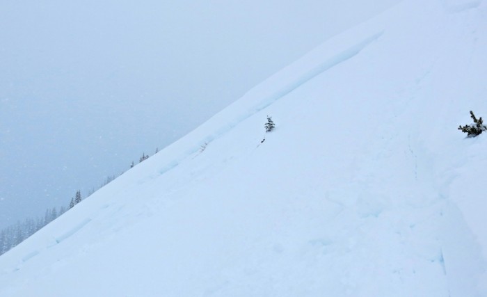
AS-SS-R1-D1.5-I Remote triggered soft slab.

Kebler Pass Area

CBAC2014-15 Observations

DATE: 2/27/15
LOCATION: Kebler
ELEV: 9,000-12,000
ASPECT: N-NE
WEATHER: OVC & BKN,  winds calm BTL & Mod gusting to strong @ TL & Alpine but chaotic directions S0-S2 pulses, PP, GP, 0.5 -3mm  2-3″ over the day

AVALANCHE/SNOWPACK OBS: Many sluffs spindrift off steep terrain & cliffs, slashed a couple 35-40* small roll overs & only got one tiny slab to pop off, the rest sluff’d

SNOWPACK: Numerous (>12) collapses & shooting cracks on flats & N-NE slopes up to 30* 9,500ft to 12K failing ~30-40cm into the old NSF with the underside of the slab (can hold it in your hand) from last week embedded with facets. Ski pen 30-40cm

Mt Emmons

CBAC2014-15 Observations

DATE: 20150227
LOCATION: Emmons
ELEV: 9,000-12,400′
ASPECT: SSE
WEATHER: OVC & BKN, snowing S1, light NW winds at ridge top in alpine as of 1200

AVALANCHE/SNOWPACK OBS: About 25-30cms of dense, thick storm / wind deposited snow in the alpine as of 1200. Small cracking at ridge top but no propagation. Small and thin eggshell rime crust observed above TL on low angle SSW slopes. 2 small D1 slides ran in steep E terrain below ridge top and from exposed rocks and cliff bands in past few days.

Untitled_5

CB Avalanche Center2014-15 Observations

LOCATION: Cement Creek Area
DATE OF OBSERVATION: 02/28/2015
NAME: ADB
SUBJECT:
ASPECT:
ELEVATION: BTL


AVALANCHES:

WEATHER: Mostly cloudy with periods of S-1 and S1. Calm

SNOWPACK: Hand test: top layer had 5cm of recent snow (last 48 hours), overlying a sun crust. Below the sun crust were 5 cm of faceted grains, overlying a melt/freeze crust. Hand and pole couldn’t penetrate this melt/freeze crust.

UPLOADS: