Large natural on west side of Ruby Range

CB Avalanche Center2015-16 Observations

Location: Kebler Pass Area
Date of Observation: 01/14/2016
Name: Zach Guy
Subject: Large natural on west side of Ruby Range
Aspect: East, South West, West
Elevation: 10,000-11,800 ft

Avalanches: We came across a surprisingly fresh D2.5 debris pile on west side of Ruby Range. Start zone obscured by clouds. Appears to have failed in the past week because the 10″ that fell on 1/7 was not on top of the debris. Could see some flanks mid track that looked about 2 feet deep and gouged to ground. Start zone was either SW or W aspect above treeline. Speculating that it was a persistent slab triggered by either a small wind slab a few days ago or a small wet loose avalanche yesterday? Noteworthy because it is the only persistent slab we’ve seen fail in the past few weeks, and one of the only large naturals from that aspect observed during Xmess Cycle. We observed 4 fresh wet loose avalanches on S/SW aspects below treeline.
Weather: Light to moderate snow (S1-S2). Moderate WSW winds with moderate snow transport at ridgeline. Overcast. Cold temps.
Snowpack: 2″ of new snow by 2 p.m.
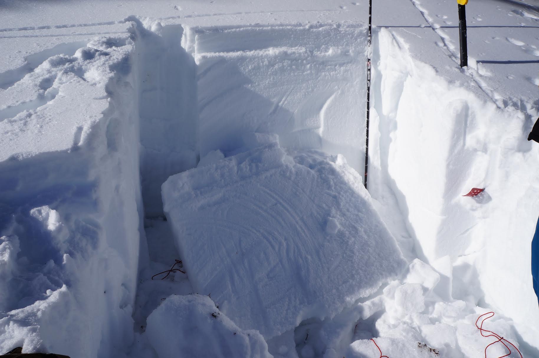
N/ATL East aspects: Snow depths ranged from 180 to 250 cm. No wind effect in recent snow (ski pen was shin deep), except some slightly stiffer snow at ridgeline. No signs of instability on steep terrain.
N/ATL West aspects: Variable snow depth and structure; difficult to generalize. Upper start zones were mostly shallow and faceted (<50cm), with some pockets up to 180 cm deep with variable hardness structures. No signs of instability.

Small wet loose below treeline
Debris looking up towards obscured start zone
Looking down at debris.  Broken tree limbs and several meters deep.

Mountain Weather 1/14/2015

CB Avalanche CenterWeather

Date: 01/14/2016

Our recent clear sky weather and calm winds are no more as three disturbances will move through our area heading into the weekend. The first disturbance moves in today, but there isn’t anything to impressive about it. Bet we’ll see a trace of snow in CB and maybe a couple inches in the favored areas west of town by Friday morning. The next in the series moves in on Friday, this storm has a more available moisture and better dynamics, but it will be passing through the area quickly. So the bursts of snowfall will be short lived. The next storm then comes in around Saturday night and we don’t have the details for this one yet. In general, we’ll see unsettled weather through the weekend with stronger winds and periods of increased snowfall.

Crested Butte Area

CB Avalanche Center2015-16 Observations

Location: Crested Butte Area
Date of Observation: 01/13/2016
Name: Donny
Subject: Crested Butte Area
Aspect: West, North West
Elevation: 9000’ to 11,800′

Avalanches:
Weather: High thin clouds, light north wind above 11,500’ and Africa Hot – 34ºF at 11,000’ at 1:00.
Snowpack: No signs of instabilities. No slab present on any part of tour – full depth facets with HS between 50cm and 80cm.

Emmons Structure

CB Avalanche Center2015-16 Observations

Location: Crested Butte Area
Date of Observation: 01/13/2016
Name: Evan Ross
Subject: Emmons Structure
Aspect: North, North East, South East
Elevation: 9,000 to 12,000

Avalanches:
Weather: Mostly clear with high thin clouds building by 11am. Calm wind. Very cold inversion already set up again while crossing the slate river at 3:30pm.
Snowpack: Near surface facets or weak surface snow is all over the place. Recent winds have buffed or stripped snow from north to west facing slopes near the summit ridge lines of Mt. Emmons.

Snowpack structure on a protected SE aspect, 32 degree slope at 11,200 was just crusts and facets for about 80cm without any slab or avalanche problem.

Snowpack structure in Redwell just after dropping into the bowl and where the slope becomes uniform below cliffs, NE aspect 35 degree slope at about 12,100, was a perfect and scary feeling persistent slab set up. HS 130, with an estimated 1f to 4F+ slab about 60cm thick over about 60cm of very weak feeling structure below. Still, many tracks on slope with no result. If that same structure exists on the steeper slopes in the area where there are no tracks, then they seem like they could still produce a persistent slab avalanche. Only had a chance to sample this one small area in this large terrain feature.

Snowpack structure in the north facing runout of redwell below 10,600ft was a simple weak, faceted snowpack with little layering remaining.

Mountain Weather 1/13/2016

CB Avalanche CenterWeather

Date: 01/13/2016

Cold valley inversions will once again warm throughout the day with one last sunny day this week. A series of three short waves will then move through our area over the remainder of the week. The first will start arriving tonight with increased clouds and a couple inches of snow tomorrow. We should see better snow accumulation out of the next shortwave passing Thursday night into Friday. This system has better moisture but will move through the area quickly, so snow showers will be shorter lived. Then we’ll see another shortwave moving through around Saturday night. These are just small storms, but combined together they should keep conditions fresh this weekend.

Crested Butte Area

CB Avalanche Center2015-16 Observations

Location: Crested Butte Area
Date of Observation: 01/11/2016
Name: Donny
Subject: Crested Butte Area
Aspect: North East, East
Elevation: 11,200

Avalanches:
Weather:
Snowpack: 32º slope, ENE Aspect @ 11,200’ near Gothic. SkiPen: 15cm; BootPen: 50cm; HS 115; 0-10cm sintered DH; 10-30cm F+ Facets; 30-100cm SLAB, 1F at bottom, 4F at top; 1cm of sun crust; top 15cm recent storm snow, fist hard. ECTP (15) (x3) failing within facets about 25cm from ground. The slab popped right out.

We skied the slope and didn’t observe any signs of instabilities.

unnamed

Crested Butte Area

CB Avalanche Center2015-16 Observations

Location: Crested Butte Area
Date of Observation: 01/10/2016
Name: Dave
Subject: Crested Butte Area
Aspect: North, North East
Elevation: 9,500- 10,800

Avalanches:
Weather: Mostly clear. Very beautiful day. Light N/NW wind; temps in low teens, felt warmer.
Snowpack: Travelled on terrain up to 34 with no signs of instability. We toured to up the west side of coney’s, students put in a great skin track. 1st lap up students dug tests pits, HS ranged from 95cm to 120cm on North aspect. Students got hard to no results on CT tests on DH layer.. There is still a soft slab resting DH/facets (no surprise)!!

Crested Butte Area

CB Avalanche Center2015-16 Observations

Location: Crested Butte Area
Date of Observation: 01/10/2016
Name: Krista
Subject: Crested Butte Area
Aspect: South East, South, South West
Elevation: 9,200’ to 11,600

Avalanches:
Weather: Mostly clear. Very beautiful day. Light N/NW wind; temps in low teens.
Snowpack: Travelled on terrain up to 35* with no signs of instability. We traveled up and then down mostly in the trees and found an average HS of 70-110cm, with a 25-40 cm slab resting above 15cms of facets. Stability tests revealed CTN in 2 separate locations on S/SE aspects at 10,200/11,000 ft. Top 20-35cm of new snow made for good skiing above the supportive midpack/slab.

Paradise Divide Area

CB Avalanche Center2015-16 Observations

Location: Paradise Divide Area
Date of Observation: 01/12/2016
Name: Ryan Hoynacki
Subject: Share the Slate
Aspect: South West
Elevation: 11500

Avalanches: Skier triggered wind slab during ski cut, 35 degree slope, 40 ft wide, ran 50 ft, 1 ft crown. Bed surface was a firm crust layer.
Weather: Clear, light wind, 10 degrees
Snowpack:

Whetstone

CB Avalanche Center2015-16 Observations

Location: Crested Butte Area
Date of Observation: 01/12/2016
Name: Zach Guy
Subject: Whetstone
Aspect: North East, East, South East, South, South West, West
Elevation: 9,000- 12,500

Avalanches: One fresh looking D1.5 or D2 debris pile below a south facing slope above treeline, near Pearl Pass, viewed from a distance. Start zone was obscured by cliffs, but assuming it was a natural wind slab from the past few days. More small skier triggered facet sluffs below treeline.
Weather: Thin clouds increased through the day from few to broken. Light winds with no transport. Cold temps at valley bottom, mild temps above treeline.
Snowpack: See video. Surface hoar below treeline and near surface facets on all aspects/elevations, beat up by winds above treeline. The surface became moist on southerly aspects near treeline today, with small grained facets above.

Isolated pockets of recent windloading produced cracking up to 6″ deep on S/SE rollovers above treeline

Near and below treeline, the snowpack was shallow (<70cm) and entirely faceted (F to 4F) Persistent slab was unreactive ( ECTX and ECTN failures) in tests, even on leeward, deeper aspects (NE, E), We could find isolated pockets of discontinuous persistent slab structure within the first 20 feet of windloaded ridgelines, but the slab did not extend down slope. Above treeline on E aspects, we found 1F to Pencil hard slabs (70cm thick) over 3-4mm F+ hard depth hoar in our pit with propagating results (ECTP21, SC). We found similar structures identified by probing on other slopes facing E and NE above treeline. Difficult to tell how continuous the PS structure is on ATL start zones…obvious variability due to winds but I didn’t want to venture onto anything steep. S, SW, and W aspects N/ATL were visually shallow and you’d be hard pressed to find a slab anywhere; lots of rocks or bushes showing. We skied a steep south aspect ATL with no signs of instability.

Faceted slab. NE aspect NTL. ECTN failure.

Faceted slab. NE aspect NTL. ECTN failure.

ATL, E aspect. 1F to P hard slab over 3-4mm depth hoar. ECTP21, SC

ATL, E aspect. 1F to P hard slab over 3-4mm depth hoar. ECTP21, SC

Cracking on isolated wind drifts, 6" deep

Cracking on isolated wind drifts, 6″ deep

Surface hoar below treeline

Surface hoar below treeline

Thin coverage on W, SW, S aspects N/ATL. West aspect NTL shown here

Thin coverage on W, SW, S aspects N/ATL. West aspect NTL shown here