


Mountain Weather 1/12/2016
Date: 01/12/2016
It may be cold but at least we’ll have the sun the next couple days. Our weather will continue with inversions and cold valley temperatures today and tomorrow and highs rebounding into the 20’s. The first change in weather will be some high thin clouds building on Wednesday afternoon ahead of a small pacific disturbance arriving Wednesday night. We’ll pick up a little snow by Thursday morning before better moisture/dynamics arrives on Thursday night. We’ll look closer at these forecasted snowfall numbers with the updated model runs tomorrow.
Today
High Temperature: 25 to 30
Wind Speed: 5 to 15
Wind Direction: NW
Sky Cover: Mostly Clear
Snow: 0
Tonight
Low Temperature: 8 to 12
Wind Speed: 5 to `5
Wind Direction: W, NW
Sky Cover: Mostly Clear
Snow: 0
Tomorrow
High Temperature: 27 to 32
Wind Speed: 5 to 15
Wind Direction:
Sky Cover: Mostly Clear
Snow: 0
Crested Butte Area
Location: Crested Butte Area
Date of Observation: 01/11/2016
Name: JSJ
Date of Observation: 01/11/2016
Name: JSJ
Subject: Crested Butte Area
Aspect: North East
Elevation: 9,300’ to 11,000
Aspect: North East
Elevation: 9,300’ to 11,000
Avalanches:
Weather: Clear & Cold. -7F @ 9:00 / 8F @ 1430 at TH. Light down valley N winds in afternoon, ridge top blowing from NNW all day, calm in valleys. .
Snowpack: Lots of needled surface hoar growth observed on all aspects of the compass, and throughout all elevation bands throughout our tour today. Predictably skier triggered 2 separate Loose Dry Snow slides (R1/D.5) on 35* terrain; full-depth facet sluffing to the ground where the slope previously avalanched during Xmas cycle. Slow moving and small entrainment. No other instabilities noted while traveling on slopes
Observation
Location: Kebler Pass Area
Date of Observation: 01/11/2016
Date of Observation: 01/11/2016
Subject: Observation
Aspect: South East, South
Elevation: 1150
Aspect: South East, South
Elevation: 1150
Avalanches: Observed evidence of 4-5 small (D-1) wind slab avalanches in south facing slopes, above treeline around 11k feet. In our group, a skier triggered a small wind slab while bootpacking on a SE slope about treeline on a 38 degree slope. It was about 20′ wide and up to 6″ deep.
Weather: Clear, Cold, Gusty.
Snowpack: Although it was cold, snowpack was moist.
Windslab problem
Location: Kebler Pass Area
Date of Observation: 01/11/2016
Name: Eliot Rosenberg
Date of Observation: 01/11/2016
Name: Eliot Rosenberg
Subject: Windslab problem
Aspect: South East, South
Elevation: Approx. 12,000 feet
Aspect: South East, South
Elevation: Approx. 12,000 feet
Avalanches: Small skier triggered windslab avalanche on Ruby at approx. 12,000 ft. on a 35+ degree, SSE slope. Slide broke near rocks during our initial bootpack approach and propagated approx. 25 ft. with an eventual path approx. 60 ft. wide and 90 ft. long. Fast moving bed interface, some slabs were 6-8″ thick. Skier was caught but not carried or buried.
Weather: Cold, sunny, mostly blue skies, windy on the ridgelines and summits
Snowpack: Snow was variable, breaking trail it felt supportive until higher elevation, that’s when we got our warning
 image3
 image2
 image1
Variable PS reactivity
Location: Crested Butte Area
Date of Observation: 01/11/2016
Name: Zach Guy
Date of Observation: 01/11/2016
Name: Zach Guy
Subject: Variable PS reactivity
Aspect: North East, East, North West
Elevation: Near treeline (11,200-11,400ft)
Aspect: North East, East, North West
Elevation: Near treeline (11,200-11,400ft)
Avalanches: Spotted about 3 or 4 recent natural wind slab avalanches (D1 in size, estimated last 24 hours) on S and SE aspects above treeline in the northern portion of our zone. Skier triggered 2 sluffs on steep, shady terrain N/BTL on slopes that had previously avalanched. D1.5 in size, gouging to the ground. See photo.
Weather: Thin, few clouds. Cold temps. Light to Moderate north winds. Plumes off of northern portion of our zone this morning; then a lull mid day, then pluming again late this afternoon across whole zone.
Snowpack: About 3-4″ of recent new snow. No signs of wind effect except below south/southeast facing ridgelines ATL, where we saw top-heavy windloading with minor cracking a few inches deep. Dug 5 pits on NW to NE to E aspects near treeline across 3 different basins to check out reactivity of PS problem.
1.) NW aspect. HS 165, 105 cm slab (1F to 1F+) over basal facet layer (4F+ hard, 1.5mm rounding facets) ECTX and no signs of failure with additional loading steps.
2.) NW aspect. HS ~50 cm. Faceted snow throughout (4F to F). ECTX, slab crumbled.
3.) NW aspect. HS 150. 1F slab over basal facets (4F-, 2mm facets). ECTX, but SC failure with additional loading
4.) E aspect. HS 125. 1F slab over basal facets (F+, 2 mm facets). ECTX, but SC failure with additional loading
5.) NE aspect HS 115. 1F slab over basal facets (F, 2-3 mm facets) ECTP24, Q1 SC.

Skier triggered sluffs on steep, shaded terrain that has avalanched previously, leaving shallow faceted snowpack.
Mountain Weather 1/11/2016
Date: 01/11/2016
High pressure will dominate our weather pattern through the most of the work week, bringing mostly clear skies and strong inversions. Crested Butte is a frigid -25F this morning, while mountain temps are above zero. We’ll see temperatures rise into the 20’s today. This pattern won’t change until Thursday, when a fast-moving shortwave brings a quick bout of unsettled weather.
Today
High Temperature: 25
Wind Speed: 5-15
Wind Direction: NW
Sky Cover: Mostly Clear
Snow: 0
Tonight
Low Temperature: 5
Wind Speed: 5-15
Wind Direction: W
Sky Cover: Mostly Clear
Snow: 0
Tomorrow
High Temperature: 30
Wind Speed: 5-15
Wind Direction: NW
Sky Cover: Mostly Clear
Snow: 0
Observation 1/10/16
Location: Kebler Pass Area
Date of Observation: 01/10/2016
Date of Observation: 01/10/2016
Subject: Observation 1/10/16
Aspect: North, North East, South East, South
Elevation: 11,200
Aspect: North, North East, South East, South
Elevation: 11,200
Avalanches: Nothing since Christmas storm. No cracking, no collapsing.
Weather: The sun was warming, but most of the day was frigid. Light winds in the morning increased from the NW. Partly cloudy skies and maybe it snowed a little? Or maybe it blew outta the trees.
Snowpack: Skied south/south east around 11 am. Denser snow with a crust layer about 6-8″ under the surface and a solid base below that up to 140 cm. Skied north/northeast (45 degrees on compass), around 1:00. Cold smoke top 12″ with a persistent slab below. Basel facets found in probing in most areas even where previous avalanching had occurred.
SSE slope at 2pm became moist despite cold temps. New snow consolidated to about 4″ over a previous crust. Solid below this with no other crusts found with probing.
West Brush Creek/Teocalli
Location: Kebler Pass Area
Date of Observation: 01/10/2016
Name: Ian Havlick
Date of Observation: 01/10/2016
Name: Ian Havlick
Subject: West Brush Creek/Teocalli
Aspect: South, South West, West
Elevation: 9-11500
Aspect: South, South West, West
Elevation: 9-11500
Avalanches: Did see 6-10 D1-1.5 dry loose avalanches off steep terrain on east, south and west terrain ATL, looking like some initiated off warming rock bands.
Evidence of many wide slides on steep east facing terrain and did observe evidence of a few west facing crowns in steep aspens that ran around xmas. Some of the crowns observed looked a little more recent…possibly wildlife triggered…
photos highlight slopes that may hang in the balance still or may re-activate with future loads in a more destructive avalanche…steep convexities slid, but more planar slopes did not…
Weather: Clear, cold with light northerly breeze with visible transport off high peaks (teo, whiterock) at times. High around 20ºF. Morning temp at TH at 10am was 2ºF.
Snowpack: Generally shallow, weak, and faceted. with average HS 50-80cm.
One pit today, 70cm, 33* slope, SW facing NTL. Ct14 SC on basal depth hoar 4-6mm, but skinned 38*+ terrain with no signs of instability. I think persistent grains definitely exist on all aspects and elevations but slab has eroded. Sledding was challenging with track augering badly in shallow snowpack, don’t take your thumb off the throttle!

fresh D1.5 loose avalanche initiated off warming rock bands on SE facing steep slope on Teocalli

more recently triggered slide possibly from wildlife, East facing, BTL, West Brush Creek
 Screen-Shot-2016-01-10-at-9.14.25-PM
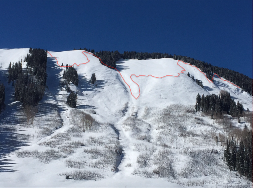
East facing West Brush Creek