Coney’s Obs 1/20/16

CBAC2015-16 Observations

Location: Crested Butte Area
Date of Observation: 01/20/2016
Name: JSJ / Jeff Banks / Geoff Unger
Subject: Coney’s
Aspect: North, Northeast
Elevation:9,300- 11,000

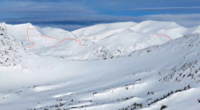
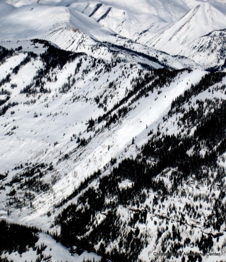
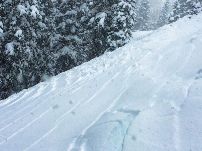
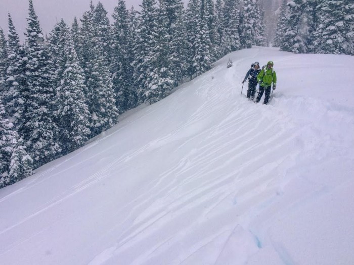
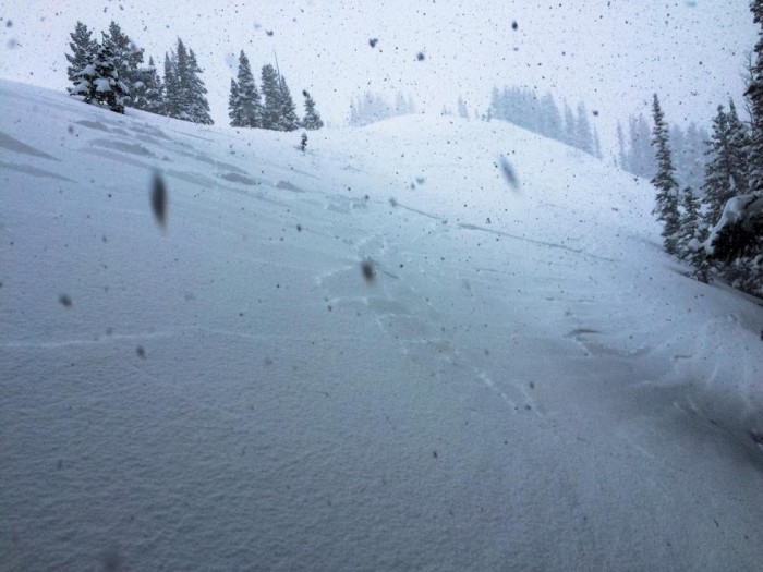
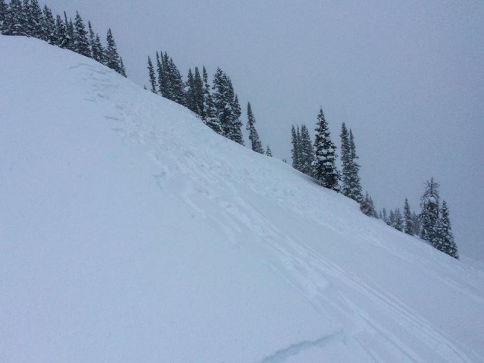
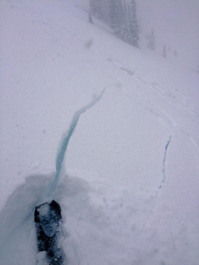
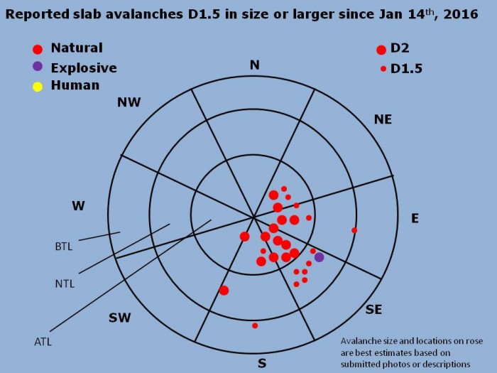
Avalanches: Widespread instabilities with shooting cracks and F hard soft slab avalanches easily initiating, but not getting past the ‘cracking & gliding’ phase on all terrain >35*. Some propagating up to 75M across.
Weather: Overcast to Obscured skies; Steady S1 snowfall with intense bursts of up to S5; Calm morning, with NW / N / NE winds Moderate to Strong at ridge top picking up around 1400. 45cms HST observed, with a window of 15cms in 3.5 hours today.
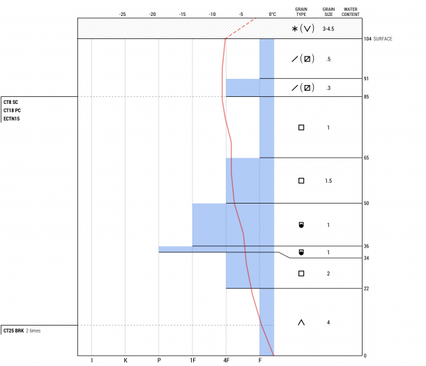
Snowpack: Failure layer observed was a well preserved layer of stellar dendrites beneath slightly denser storm snow, found 20cms below the surface. Snowpack tests revealed CTMSC and ECTNM failures on the 1/14 buried surface facet layer, but no activity seen stepping down to this layer while traveling through terrain today. Surface slabs were F to F- in hardness, but Mod to Strong winds made an appearance around 1400 and began slabbing up the low density storm snow into a more cohesive slab.
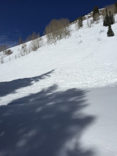
unnamed unnamed (1) unnamed (2) unnamed (3) unnamed (4)

Pittsburgh (aka Japan) natural storm activity

CB Avalanche Center2015-16 Observations

Location: Paradise Divide Area
Date of Observation: 01/20/2016
Name: MR
Subject: Pittsburgh (aka Japan) natural storm activity
Aspect: North East, East, South East
Elevation: 9300-10500

Avalanches: widespread natural and triggered storm instabilities, all just in the top storm layer. Widespread cracking on the skin track, and natural rippled cracking on all slopes at 35 degrees or so. On our last lap track around 1:30 pm as the rimed snow started to collect we encountered several natural events – am 8 inch storm slab, possibly triggered by a tree bomb, covered the skin track, running 100 feet or so. Pretty much any slope steep enough on this last lap had either slid or ripple cracked, all within the last 45 minutes. All just the top 6-8 inches, no stepping down. At the top of the skin track either we remote triggered or a natural released off the flank of schuykill above us, ENE aspect, maybe releasing from 11200 and running to the shelf at 10,500. Obvious crown ran more or less the full width of the face, but it was broken up , not sure if it all ran at the same time or not. Again just the top 8 inches or so, and ran as loose dry snow, deposition zone looked like sluff. R2D1 but ran with plenty of energy and would have taken you for a ride over cliffs into trees.
No other instabilities observed while skiing.
Widespread cracking on several slopes above the road on the sled ride back out, SW aspect.
Weather: s3 to s5 snow throughout the day, gaining in intensity and becoming more rimed in the afternoon. Gusty winds. Warm, maybe mid 20’s?
Snowpack: At 10,300 NE aspect at 2 pm measured 35cm new snow, but not sure how accurate that is, hard to differentiate between the past 24 hours and the previous 24. 48 hour snow total maybe 50cm? Ski pen 45cm boot pen crotch deep.

P1000592

Gothic obs 7am

CB Avalanche Center2015-16 Observations

Location: Crested Butte Area
Date of Observation: 01/20/2016
Name: billy barr
Subject: Gothic obs 7am
Aspect:
Elevation:

Avalanches:
Weather: Moderate, steady snow starting after midnight with 6″ new so far but a very light 0.22″ of water. Snowpack at 44″. Currently moderate snowfall conrinues. Snowpack water content as of 2 days ago at 8.28″. Very light density snow so far will have little effect on overall snowpack other than some very light surface sloughing, if that, but will be susceptible to wind. As are we all. billy
Snowpack:

Mountain Weather

CB Avalanche CenterWeather

Date: 01/20/2016

We are waking up to steady snow from our latest disturbance affecting the area today. Lower elevations may see snow taper off midday, before good orographics and cold air advection from -30ºC cold air aloft, and a fast moving jet stream redevelop snow this evening in northwest flow, wringing out every possible flake over the higher peaks. The fast moving jet stream will increase WNW winds into sunset, with some 50mph gusts at higher elevations. A strong northerly flow shifts over the state and cold temperatures return for Thursday and Friday.

CBAC Snodgrass Study Plot Snowpit

CB Avalanche Center2015-16 Observations, Snow Profiles

Location: Crested Butte Area
Date of Observation: 01/19/2016
Name: Jimmy Buchanan
Subject: CBAC Snodgrass Study Plot Snowpit
Aspect: North East
Elevation: 9,800′

Avalanches: None.
Weather: See profile.
Snowpack: See profile.

Snodgrass-Jan.-19

Pittsburg area

CB Avalanche Center2015-16 Observations

Location: Paradise Divide Area
Date of Observation: 01/18/2016
Name: Daniela Runge
Subject: Pittsburg area
Aspect: South
Elevation: 9000

Avalanches: Between Pittsburg before camo glades. Occurred between 11-1:30. Soft slab. Class 2. South facing. Maybe 40 ish feet across? Ran maybe 80 feet?
Weather: Mostly sunny, 25 degrees.
Snowpack: Fresh snow.

20160119SlateRIveravalancheIMG_1359

Mountain Weather

CB Avalanche CenterWeather

Date: 01/19/2016

Our system that moved in quickly yesterday around sunset will exit the region today, with only a few hours of clearing before yet another weaker disturbance rolls into the Elk Mountains this afternoon and evening, along with increases in westerly winds. If you like snow, the model confidence is high that the active pattern continues with yet another system through mid week, and another series of storms looking to line up again toward the weekend and early next week.

Kebler Pass Area avalanches

CB Avalanche Center2015-16 Observations

Location: Kebler Pass Area
Date of Observation: 01/18/2016
Name: Evan Ross
Subject: Kebler Pass Area avalanches
Aspect:
Elevation:

Avalanches: 1 natural slab avalanche released around 2pm on a cross loaded southwest terrain feature, WS-N-R2-D2-U. Observed another wind slab avalanche on a SE terrain feature near tree line at about 11,300ft. R1-D1.5 that may have released naturally in the afternoon for been remote triggered around the same time, by a snowmobile track a few hundred feet away.

Observed nummeres other slab avalanches in the Ruby Range and north the to the Maroon Bells Wilderness, mostly on southeast to east to northeast facing wind loaded slopes. These were generally in the R2-D2 range and would have failed during the tail in of our recent storm or today. Some of these avalanches were repeat offenders, avalanching on the same slopes that avalanche during the Christmas cycle.
Weather: Partly Cloudy Sky and strong enough sun to moisten snow surfaces on southerly slopes protected from wind. West to southwest winds direction in our area was drifting snow throughout the day onto lee terrain features. Snow plumes could also be seen in the Anthracite Range, Ruby Rang, Crested Butte Area and bordering Maroon Bells Wilderness throughout the day.
Snowpack:

IMG_1257

One very large slab, estimated as R3-D2.5 and another smaller slab on the right of the photo. Both in the Ruby Range above the upper OB Joyful drainage.

Blowing snow throughout the day, all the way north to the bordering Maroon Bells Wilderness

Several D1.5-D2 slabs below Scarps Ridge on wind loaded northeast terrain

Several repeat offender slabs that failed during our recent storm on slopes that also avalanched during the Christmas cycle

IMG_1269

R1-D1 wind slab that released naturally on 1/18 or was remote triggered by a snowmobile track a few hundred feet away.

1/18 Large Natural off S aspect of Schuylkill Ridge

1/18 around 2 pm, Large Natural in cross loaded SW terrain of Schuylkill Ridge.