20″ wind slab at Irwin

CB Avalanche Center2016-17 Observations

Location: Kebler Pass Area
Date of Observation: 02/20/2017
Name: Irwin Guides
Subject: 20″ wind slab at Irwin
Aspect: East
Elevation: 11800 ft

Avalanches: 1 decent windslab triggered in Bender (East, 11,800′, 38 degrees) under foot. SS-ASc-R1-D1.5-I Triggered while walking across the edge of the ridge. 50cm deep, 50′ wide ran 400′ on the February 19 smooth crust. Several small dry loose and wet loose.
Weather:
Snowpack: 10″ with .9 SWE.

unnamed-3
unnamed-2

Wind Slab Avalanche

CB Avalanche Center2016-17 Observations

Location: Kebler Pass Area
Date of Observation: 02/20/2017
Name:
Subject: Wind Slab Avalanche
Aspect: North
Elevation: 11,800

Avalanches: SS-ASr-R2-D2-I. A Group of four skiers to our left, remotely triggered a slide from about ~100′ away. Slide was triggered from ridge top. Slide propagated within a large wind roll, proceeded to run ~1,500′.
Weather: Sunny, light winds out of the west.
Snowpack: No obvious signs of instabilities on the hike up. Noticed some point releases that had run yesterday, all start zones were from under cliff bands.

The slide was triggered from where the 2 skiers are standing in this photo.

Blue Bird

CB Avalanche Center2016-17 Observations

Location: Cement Creek Area
Date of Observation: 02/20/2017
Name: ADB
Subject: Blue Bird
Aspect: North, North East, East
Elevation: BTL

Avalanches: Nada.
Weather: Few clouds within the area and calm.
Snowpack: Between 2 to 5 inches of snow/24 hours. Lower 900 feet had 2 inches on top of rain crust from Friday.

Less than 2cm surface hoar already forming.

Emmons

CB Avalanche Center2016-17 Observations

Location: Kebler Pass Area
Date of Observation: 02/19/2017
Name: Will Nunez
Subject: Emmons
Aspect: North, South, West
Elevation: 9,300-12,300

Avalanches:
Weather: Brocken to increasing clouds with light to moderate winds out of the W-SW. Southerly slopes received strong solar with temps in the mid 30F. Light snowfall started around 1300 and increased to S1 to S2 with 2-3” new snow through out the afternoon by 1530.
Snowpack: No signs of instability of any instability where observed. The new snow that started at 1300 produced some fast moving sluffs on steeper NW slopes. A quick pit on a NW aspect shows F 4F 1F P HS 270cm Compression test had no results. The buried SH was found at 184cm the buried SH was unreactive and starting to round; it was also hard to separate the interface. Small to large sluffs were observed on S-SW- E slopes. Evidence cornice falls on E aspects were also observed.

Mountain Weather 2/20/2017

CB Avalanche CenterWeather

Date: 02/20/2017

A temporary ridge will bring decreasing sky, warming temperatures and continued gusty winds today. This afternoons clear sky will be short lived as we head into more unsettled weather for the week. Colorado will be just south of moist southwest flow ramming into Utah and Wyoming. Being on the edge of this weather, Colorado will see clouds increase on Tuesday with a small chances of light snow showers at times lasting through Wednesday. Around the Wednesday night into Thursday time frame, a short wave trough will push that weather further south and bring more active weather to our area.

West Brush Obs

CB Avalanche Center2016-17 Observations

Location: Brush Creek Area
Date of Observation: 02/19/2017
Name: Zach Guy
Subject: West Brush Obs
Aspect: North East, East, South East, South, South West
Elevation: 9,000-13,000 ft.

Avalanches: No new avalanches. Some cracking/storm slabs 2″ thick on the 2/17 near surface facet layer on NE aspects NTL; completely harmless but an indicator of how fragile that layer is right now.
See photos of older avalanches that ran during last storm or during the warm-up. Glide avalanches, persistent slabs, wet loose, and wet slabs.
Weather: Scattered clouds increased to overcast by late morning; S1 to S3 began around 12:30 p.m, about 2″ accumulation by late afternoon. Light SW winds with light snow transport at ridgeline. Mild temps.
Snowpack: Thick, supportive, frozen crusts on southerly slopes and no avalanche concerns on these aspects. Dry snow still on northerly aspects. The freshly buried 2/17 near surface facet layer was more pronounced/widespread on northerly near and below treeline slopes. Wind battered ATL here.  Didn’t see obvious signs of facets around the crusts on southerly slopes, except where the crusts were thin on low angle slopes. 3 pits on northeast aspects were as follows:
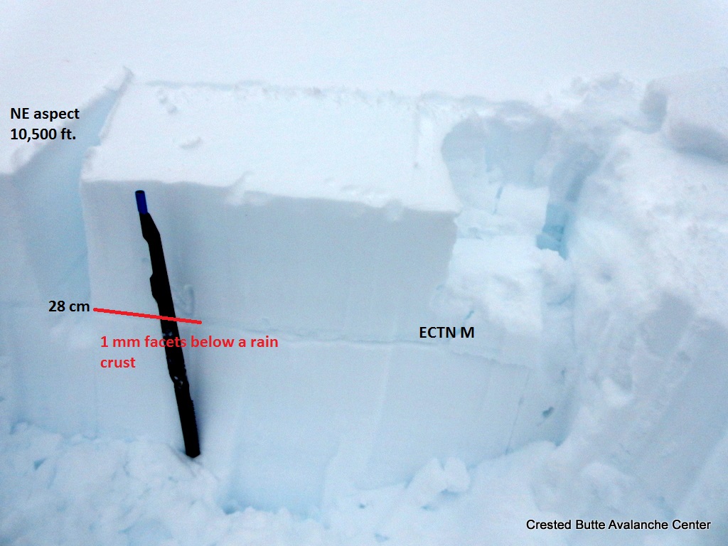
1) 10,500 ft. Thin melt-freeze crust about a foot deep, with 1mm facets below. Not reactive under current load (ECTN M) but something to keep an eye on.  Near surface facets 1″ deep.
2). 10,700 ft. 1/19 Surface hoar layer was 90 cm deep under a 1F slab. Propagating results in ECT with 4 additional shoulder hits beyond normal loading steps (ECTP 34, SC).  Near surface facets 2″ deep.
3.) 12,900 ft. A layer of small grained, well bonded facets was buried 45 cm deep. No fractures in a CT on any layers

Some recent and older glide avalanches. Easterly aspects BTL.

Some recent and older glide avalanches. Easterly aspects BTL.

D2. NE aspect N/BTL (10,700 ft). Looks like a natural from last storm, likely the buried SH layer but could have been a shallower weak layer.

Lots of wet loose activity on E, S, W aspects, averaging D1.5. This was a D2 Wet slab on S ATL, ran sometime during the warmup.

Several D1.5 and D2s on NE aspect NTL (10,700 ft and above). Looks like they ran last storm on the 1/19 SH layer, but could have been a shallower weak layer.

D2 on NE aspect N/BTL (10,700 ft). Looks like it ran last storm on the 1/19 SH layer, but could have been a shallower weak layer.

Buried rain crust/facet layer. NE aspect 10,500 ft.

Cracking and very shallow storm slabs on 2/17 NSF layer. NE aspect NTL

3 foot dense slab over propagating SH layer. NE aspect 10700 ft.

No obvious signs of instability

CB Avalanche Center2016-17 Observations

Location: Crested Butte Area
Date of Observation: 02/18/2017
Name: Chris Pruden
Subject: No obvious signs of instability
Aspect: North East
Elevation: 9,500

Avalanches:
Weather: Warm, Calm, Mostly Sunny
Snowpack: Large glide cracks observed on a SSE aspect below the Gothic Road. Otherwise, no obvious signs of instability were observed. Our group dug to 130 cm down but was unable to identify any buried SH and nothing was reacting in a small column test. Moist Pow skiing down to the river if you stayed away from any hint of solar aspect.

Mountain Weather 2/19/2017

CB Avalanche CenterWeather

Date: 02/19/2017

A low-pressure trough will lift into Colorado this afternoon. This will bring in a warm, moist airmass on southern flow, allowing snow showers to develop late this afternoon into tonight. Some of these snow showers may have a short and intense nature to them, like an afternoon thunderstorm in the summer, thanks to convective day time heating. Winds will also be on the increase this afternoon as this next weather event arrives. A upper level ridge will bring a dry start to next week before we see a return to unsettled weather by the mid-week.

Cement

CB Avalanche Center2016-17 Observations

Location: Cement Creek Area
Date of Observation: 02/18/2017
Name: ADB
Subject: Cement
Aspect: North, West, North West
Elevation: ATL, NTL, BTL

Avalanches: None. A few rollers on descent on W/NW aspect. Lot of debris in bottom of drainage from loose snow avalanches over the past week.
Weather: Scattered skies with light winds BTL ; and moderate winds ATL with snow being transported (swirling).
Snowpack: Up to 2 inches of new snow/24 hours with rain lower 900 feet of BTL . Aside from due north aspects, crusts below new snow surface.

SH unreactive

CB Avalanche Center2016-17 Observations

Location: Kebler Pass Area
Date of Observation: 02/18/2017
Name: Tim Brown
Subject: SH unreactive
Aspect: North, North East
Elevation: 9,500-11,000

Avalanches: Saw several small dry loose avalanches that ran in the last week, but ski-cuts produced minimal sluffing on steep, shady slopes today.
Weather:
Snowpack: Except for 40cm of dry F to 4F hard facets at the surface, this is one of the deepest and stoutest mid-season snowpacks I’ve seen on Axtell. The mid-pack in this shady, wind-protected area is mostly 1F hard rounds, but there are two layers of buried surface hoar still preserved below hard snow.

Neither of these layers were reactive to snowpack tests where we looked today: ECTX x 2 and PST 90/100 (SF) on 40 degree NE-facing slope at 11,000′ with HS 280cm, PF 45cm and PS 20cm. Similar to Evan’s ob from yesterday, an informal deep tap ECT produced no results on either of these layers. It was difficult to keep the saw in the lower weak layer during PSTs as the SH seems to be lying down flat. The upper (Feb 10th) layer is composed of 3mm SH down 75cm and the lower one (Jan 19th) is composed of 7mm SH down 95cm. We easily detected the upper one in the pit wall and pried on blocks to find the lower one.

These layers may become more reactive when we get a significant load or a wetting front reaches them, but they’re getting pretty deep to human-trigger in areas where they’re buried this deep and protected by such a stiff slab. Except for 40cm of dry F to 4F hard facets at the surface, this is one of the deepest and stoutest mid-season snowpacks I’ve seen on Axtell. The mid-pack in this shady, wind-protected area is mostly 1F hard rounds, but there are two layers of buried surface hoar still preserved below hard snow.

Neither of these layers were reactive to snowpack tests where we looked today: ECTX x 2 and PST 90/100 (SF) on 40 degree NE-facing slope at 11,000′ with HS 280cm, PF 45cm and PS 20cm. Similar to Evan’s ob from yesterday, an informal deep tap ECT produced no results on either of these layers. It was difficult to keep the saw in the lower weak layer during PSTs as the SH seems to be lying down flat. The upper (Feb 10th) layer is composed of 3mm SH down 75cm and the lower one (Jan 19th) is composed of 7mm SH down 95cm. We easily detected the upper one in the pit wall and pried on blocks to find the lower one.

These layers may become more reactive when we get a significant load or a wetting front reaches them, but they’re getting pretty deep to human-trigger in areas where they’re buried this deep and protected by such a stiff slab.