Red Coon Glades

CB Avalanche Center2018-19 Observations

Location: Kebler Pass Area
Date of Observation: 02/03/2019
Name: Will Nunez

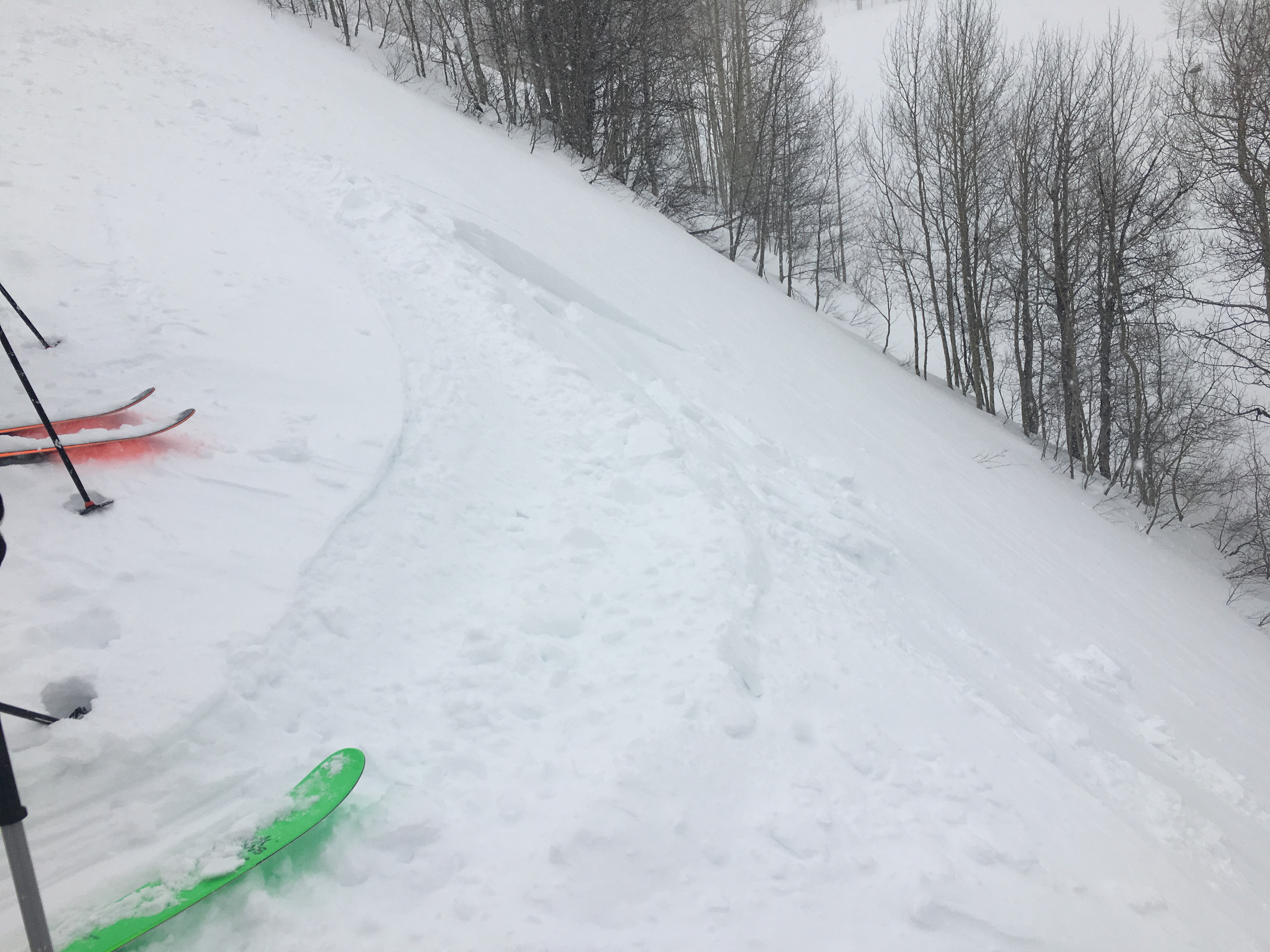
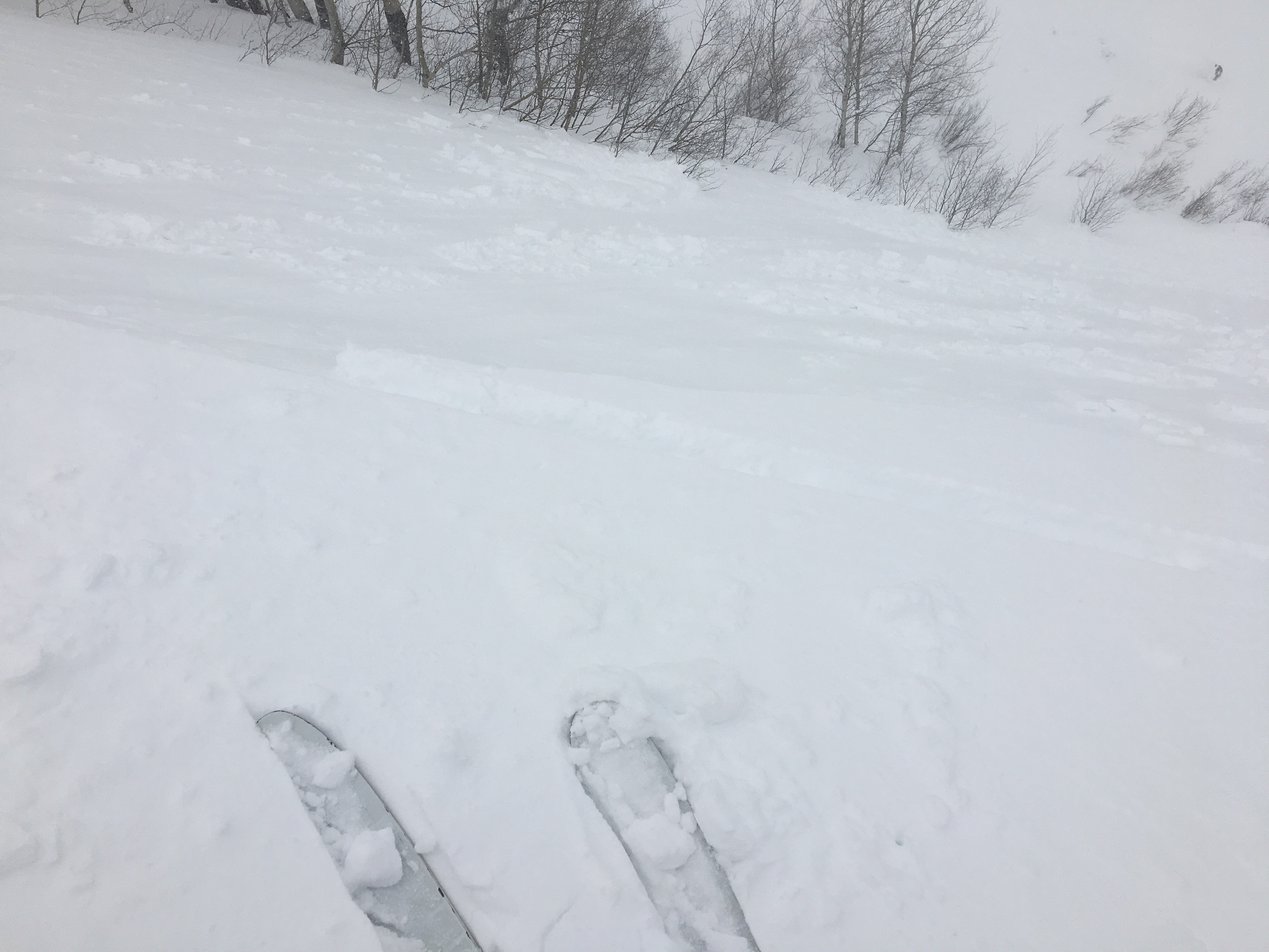
Subject: Red Coon Glades
Aspect: South East, South
Elevation: 9,600-11,000

Avalanches:

5-2” Wind slabs formed in leaward areas SE And where touchy to skier travel, releasing and intraining gully gullie features close to the Kebler TH

No other instabilities where observed

Weather: Sky’s Overcast (OVC) to Obscure (X) at times, Precipitation went from snow (SN) and mixed graupel (GR) S1-S2, Winds out of the S-SW Mod to heavy gusts, with snow plums and transport.

Snowpack: New snow accumulations ranged from 3-6” landing on a 2cm sun crust on S-SE aspects. Surface forms consisted of graupel and new snow, most old ski track where fully covered back up.
Photos:

Irwin Cat Ski Obs

CB Avalanche Center2018-19 Observations

Location: Kebler Pass Area
Date of Observation: 02/03/2019
Name: IG

Subject: Irwin Cat Ski Obs
Aspect:
Elevation:

Avalanches:

No natural avalanches observed. Ski cut triggered D1 slides in everclear, lower moonrise left, round 2 below moonrise, ray, booth, & oswald

Weather: Snowing and blowing all day. Snowing S1 with periods of S2 throughout day but underperformed forecast. Extreme winds throughout day, max gust at ridge 90mph at 2pm! Winds swirling in west wall, upslope and cross slope winds noted on pass through moonrise and thorton’s glade

Snowpack: Wind slab stiffening throughout the day in terrain we travelled. Wind slab not uniformily distributed in travelled areas. Some spots scoured down to firm surface with some noted old tracks. Felt crust below new snow on south aspects. Wind slab developed 1-2ft thick in spots. Sensitivity of wind slab characterized as reactive as we easily triggered small D1 slides with ski cuts.
Photos:

Storm Check out at Pittsburg

CB Avalanche Center2018-19 Observations

Location: Paradise Divide Area
Date of Observation: 02/03/2019
Name: Eric Murrow

Subject: Storm Check out at Pittsburg
Aspect: North East, East
Elevation: 9,200 – 10,600′

Avalanches:

Weather: Lots of wind even at valley bottoms, a low roaring was audible at all times from heavy winds up high. Light graupel from 11am to 2pm while out.

Snowpack: Checking on storm snow at 10,600′ at 130pm – about 5 inches with .6 SWE. Most of the new precip came in the form of graupel.
Open terrain features below treeline were starting to drift and crack – less than a ski length. Storm snow was very cohesive and slab-like. HS through this BTL NE facing terrain was around 150 to 160cm.

Photos:

Anthracite Mesa-Coneys; WINDY

CB Avalanche Center2018-19 Observations

Location: Crested Butte Area
Date of Observation: 02/03/2019
Name: ADB

Subject: Anthracite Mesa-Coneys; WINDY
Aspect: North East, East
Elevation: BTL

Avalanches:

NA due to poor visibility.

Weather: Moderate wind gusts in the trees and sustained strong winds from the west on the ridge line with considerable snow loading into the bowls. Really wasn’t snowing but had a few 5 minute bursts of S-1 and S1 snow. Graupel was produced mostly. Temperatures were around freezing.

Snowpack: Less than 3 inches of new snow. Cornices between 1 and 2 feet guard 60% of the bowls. 3 inch wind slabs had already formed on the ridge and winds filled in skin track on the ridge between our 2 laps. 5-15 feet shooting cracks on the 1-foot cornice on top of convex corner.
Photos:

Gothic Townsite 7am Obs

CB Avalanche Center2018-19 Observations

Location: Crested Butte Area
Date of Observation: 02/03/2019
Name: billy barr

Subject: Gothic Townsite 7am Obs
Aspect:
Elevation:

Avalanches:

Weather: Snow started just before 5 a.m. and was moderate with a dense, small snowflake with 3″ new and water of 0.29″. No wind and the overnight low of 18F, current 22F. Snowpack at 45″ deep. Snow stopped at 7 but has started up again. Overcast and calm. billy

Snowpack:
Photos:

Mountain Weather for 11,000ft

CB Avalanche CenterWeather

Date: 02/03/2019

Heavy, wet snow and strong southwest winds will develop and expand early this morning and bring solid precipitation rates throughout the day. A reinforcing wave embedded in the storm system may spike snowfall rates, drop visibilities, and potentially produce thundersnow midday. Even though models have backed off precipitation slightly from yesterday, they continue to paint accumulations across our area mountains as a quick 1-1.5” of snow water equivalent by this evening, translating to 8-14” snow in snow favored areas like Kebler and Schofield Passes, with closer to 4-8” elsewhere. We get a quick reprieve Monday before yet another, colder system with its origins in Gulf of Alaska on Tuesday and beyond.

  • Today

    High Temperature: 25-30
    Winds/Direction: 20-30/SW G50
    Sky Cover: Mostly Cloudy
    Irwin Snow: 6-10″
    Elkton Snow: 4-8″
    Friend’s Hut Snow: 3-6″

  • Tonight

    Low Temperature: 10-15
    Winds/Direction: 10-20/WSW
    Sky Cover: Mostly Cloudy
    Irwin Snow: 1-3″
    Elkton Snow: 1-3″
    Friend’s Hut Snow: 0-2″

  • Tomorrow

    High Temperature: 25-30
    Winds/Direction: 5-15/WSW
    Sky Cover: Overcast
    Irwin Snow: 0-1″
    Elkton Snow: 0
    Friend’s Hut Snow: 0

Coneys Glades Below Tree Line

CB Avalanche Center2018-19 Observations

Location: Crested Butte Area
Date of Observation: 02/02/2019
Name: Will Nunez

Subject: Coneys Glades Below Tree Line
Aspect: North East, East
Elevation: 9,600-10,300

Avalanches:

No signs of any instability, shooting cracks or collapsing

Weather: Cold, increasing clouds, LIGHT wind out of the SW, some flurries

Snowpack: Snow depth varied from 50-90cm on easterly-northerly aspects in terrain below treeline. A few hand pits revealed that the snowpack becoming faceted out throughout E-NE aspects. Fist to 4 finger minus to mid-pack and fist to the ground 2-3 mm facets, with a buried surface hoar layer ~30cm down.

Mountain Weather for 11,000ft

CB Avalanche CenterWeather

Date: 02/02/2019

After a string of mild days and nearly calm winds in the mountains, the next storm system making landfall along the California coast today will spread thickening high clouds across our area and increasing southwesterly winds will throughout the day. Valley inversions will break down slightly faster today with the extra cloud cover. Precipitation does not reach the Elk Mountains until around midnight tonight, and when it does will fall unusually warm and wet. Areas above 7,000ft will avoid raindrops. Although carrying abundant moisture, this storm system moves quickly and should depart late Sunday, however, moist westerly flow remains and could produce lingering orographic snow into Monday. Accumulations at 11,000ft will favor Kebler and Schofield Passes, where 10-20” look possible. Elsewhere, 3-6” looks realistic.

  • Today

    High Temperature: 28-33
    Winds/Direction: 10-20/WSW
    Sky Cover: Increasing clouds
    Irwin Snow: 0
    Elkton Snow: 0
    Friend’s Hut Snow: 0

  • Tonight

    Low Temperature: 15-20
    Winds/Direction: 15-25 G40s
    Sky Cover: Mostly Cloudy
    Irwin Snow: 3-6″
    Elkton Snow: 1-3″
    Friend’s Hut Snow: 1-3″

  • Tomorrow

    High Temperature: 25-30
    Winds/Direction: 20-30 SW G 60s
    Sky Cover: Mostly Cloudy
    Irwin Snow: 5-10″
    Elkton Snow: 4-8″
    Friend’s Hut Snow: 3-6″

Below Treeline Obs Snodgrass-Gothic Zone

CB Avalanche Center2018-19 Observations

Location: Crested Butte Area
Date of Observation: 02/01/2019
Name: Tim Brown

Subject: Below Treeline Obs Snodgrass-Gothic Zone
Aspect: East, South West, West, North West
Elevation: 9,400-11,000′

Avalanches:

no new avalanches, cracking or collapsing

Weather: Bluebird day with intense solar radiation, clear skies all day, warm (>0C at 11,000′ at noon), CALM in am, LIGHT winds from NW in afternoon, no blowing snow.

Snowpack: Snow depth varied from ~100cm on Westerly aspects to ~160cm on East aspects in open terrain below treeline. The entire snowpack is mostly faceted throughout this elevation band, but the mid-pack was more supportive on the deeper, East-facing slopes. East aspects harbored three distinct layers of buried surface hoar (5cm, 45cm and 70cm below the surface) under fist hard, 4 finger hard and 1 finger hard slabs, respectively. Despite these concerning layers, snowpack tests (CTN, ECTX) failed to produce positive results on an East-facing 32 degree open slope at 10,900′ with foot penetration of 45cm and ski penetration of 30cm. Continuous crust-facet combinations were present in the top 30-60cm on 30 degree Southwest-facing slopes without much recent loading, but absent on lower-angle West-facing slopes ~10,600′. The top 10-20cm became moist on steeper sun-exposed slopes below treeline today.
Photos: