Slate river Valley Climax chutes NE ridge line

CB Avalanche Center2018-19 Observations

Location: Crested Butte Area
Date of Observation: 02/12/2019
Name: Chris Martin

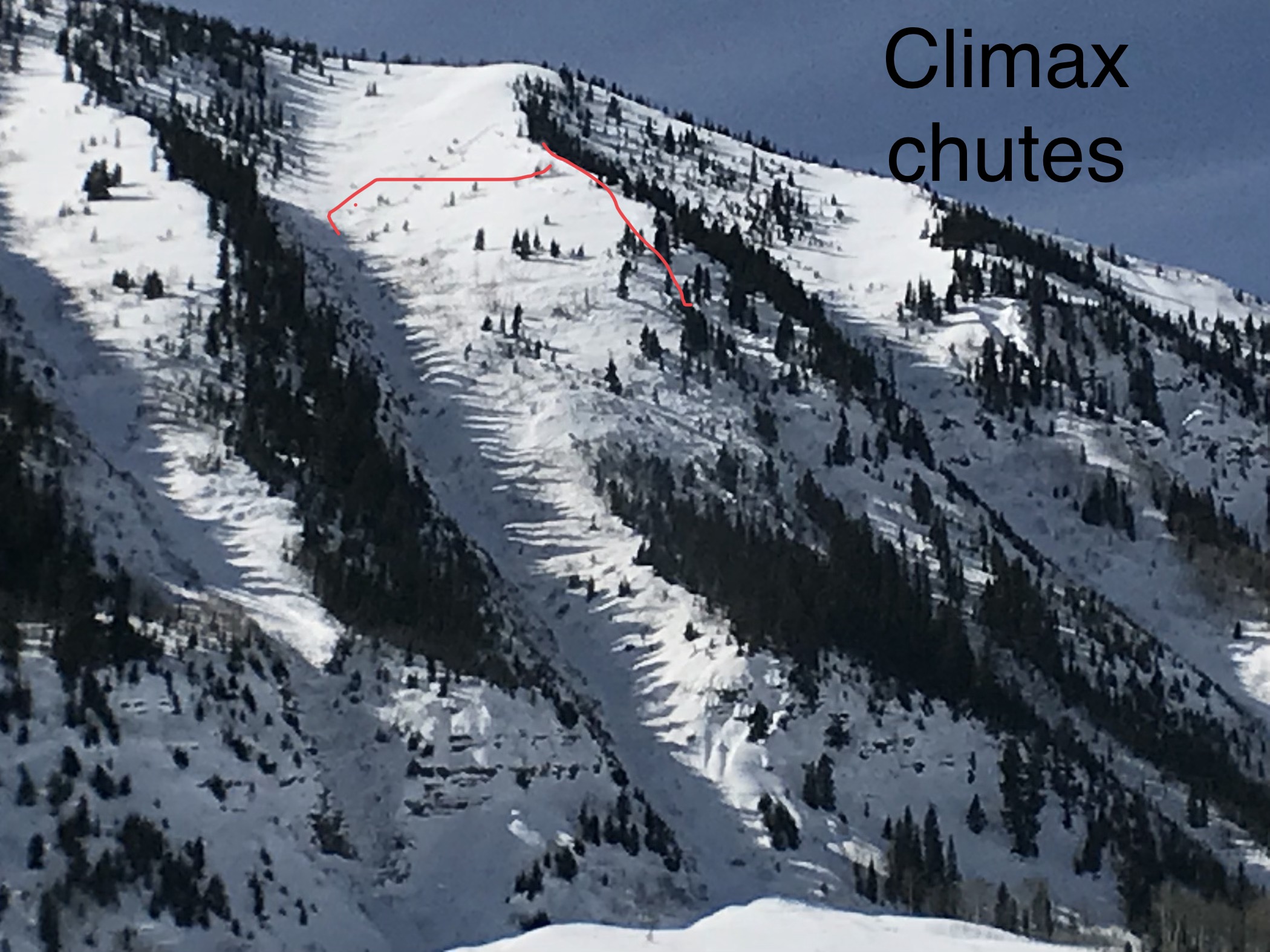
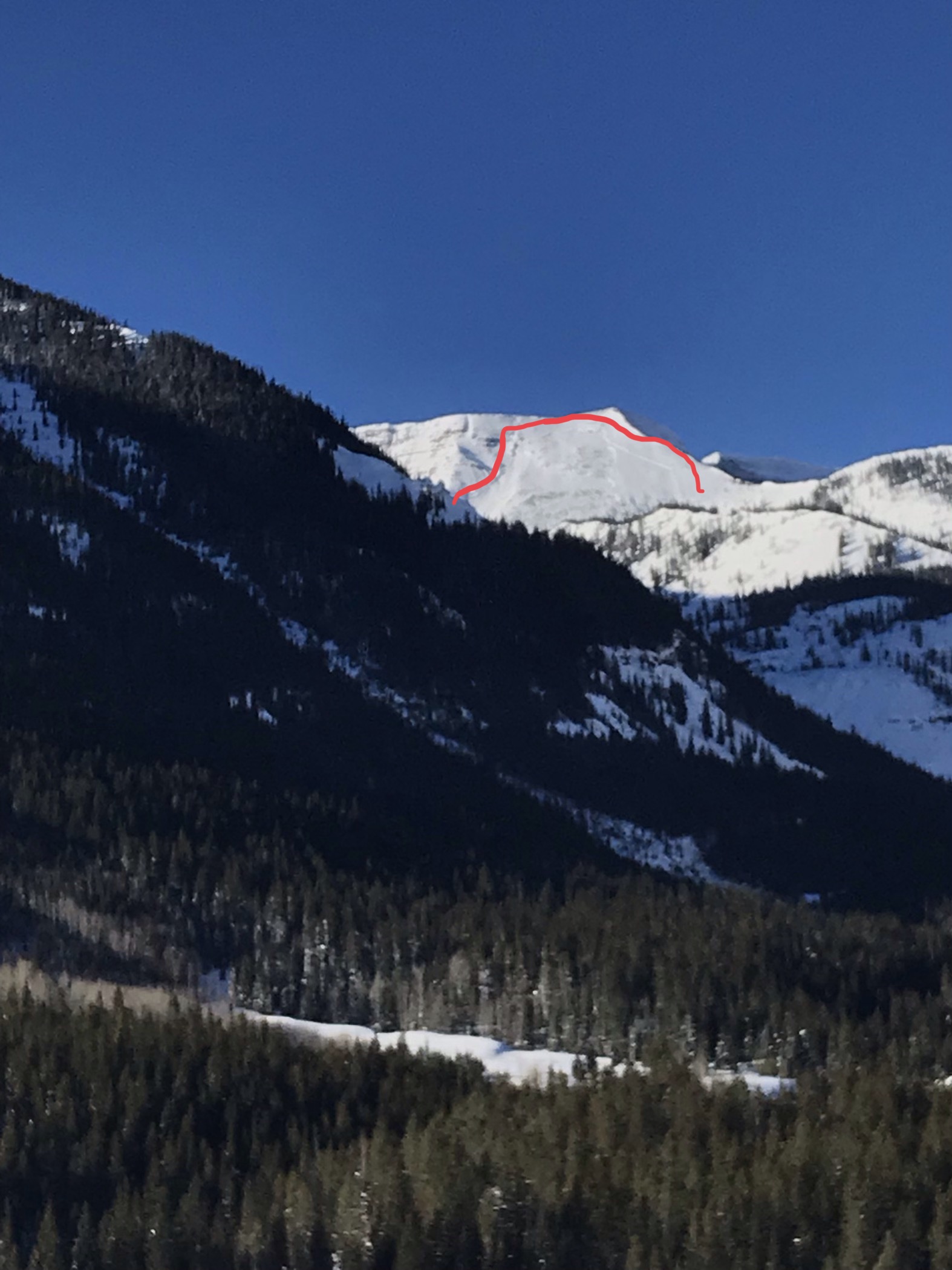
Subject: Slate river Valley Climax chutes NE ridge line
Aspect: North, North East
Elevation: 9800′

Avalanches:

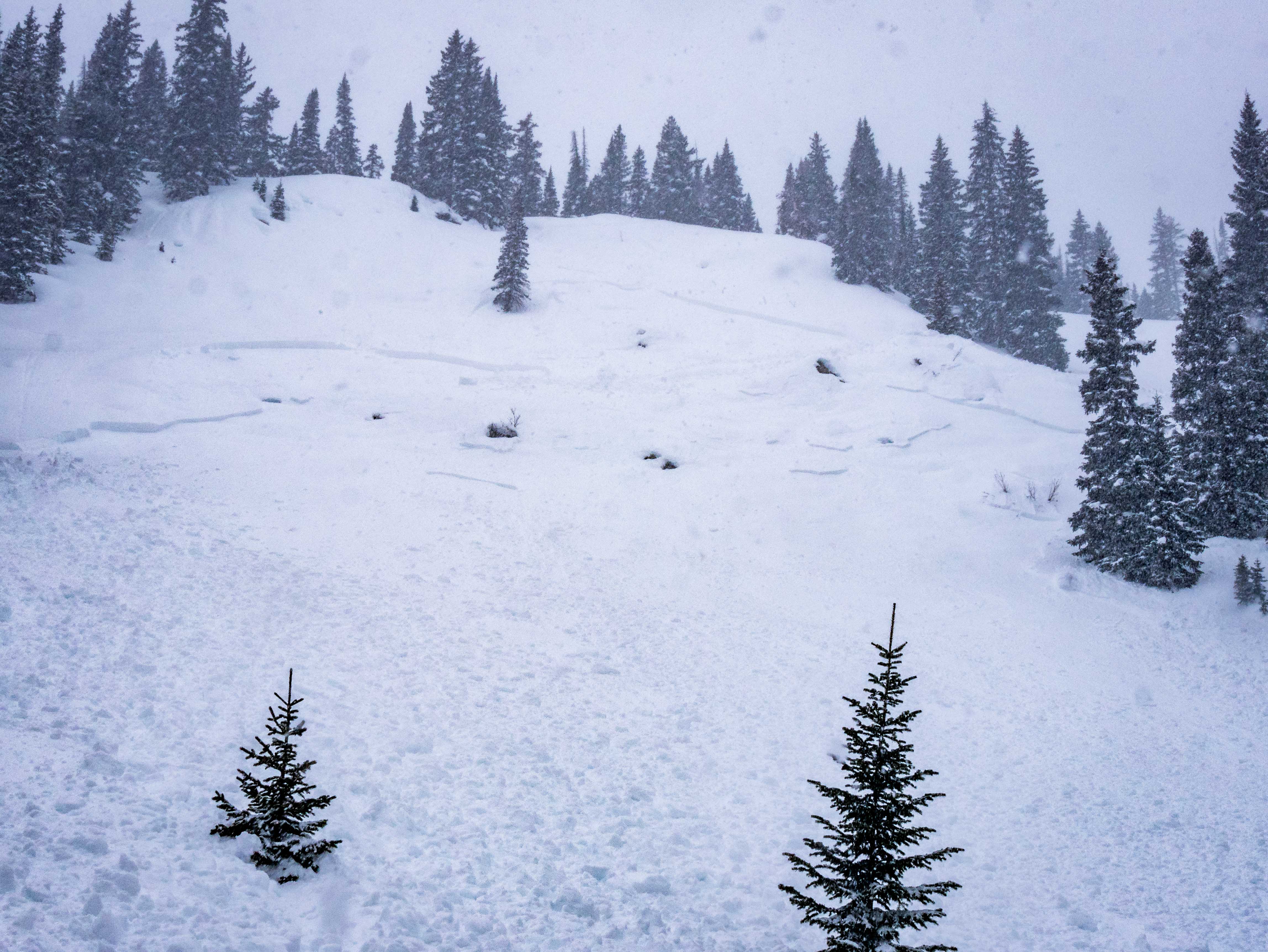
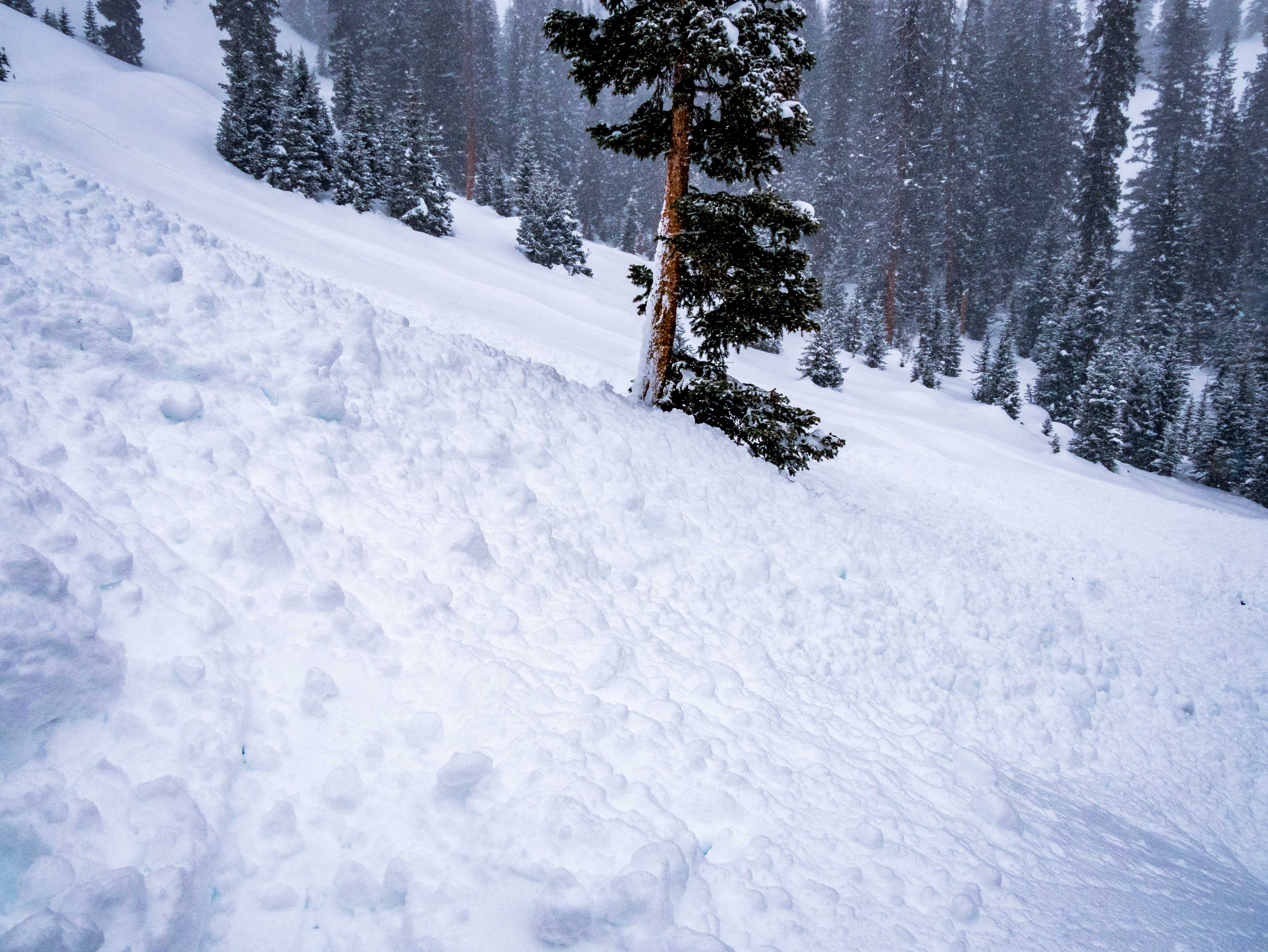
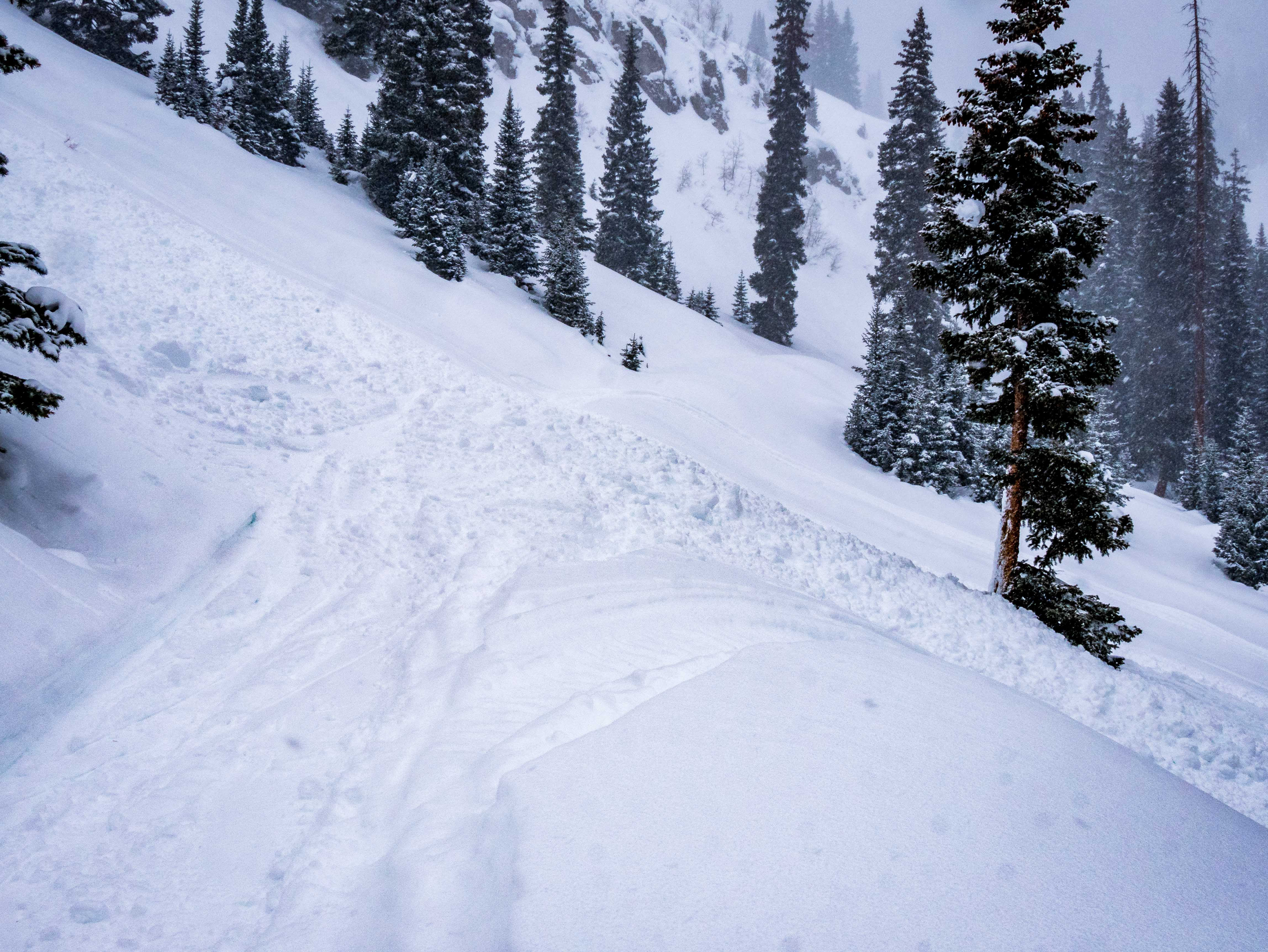
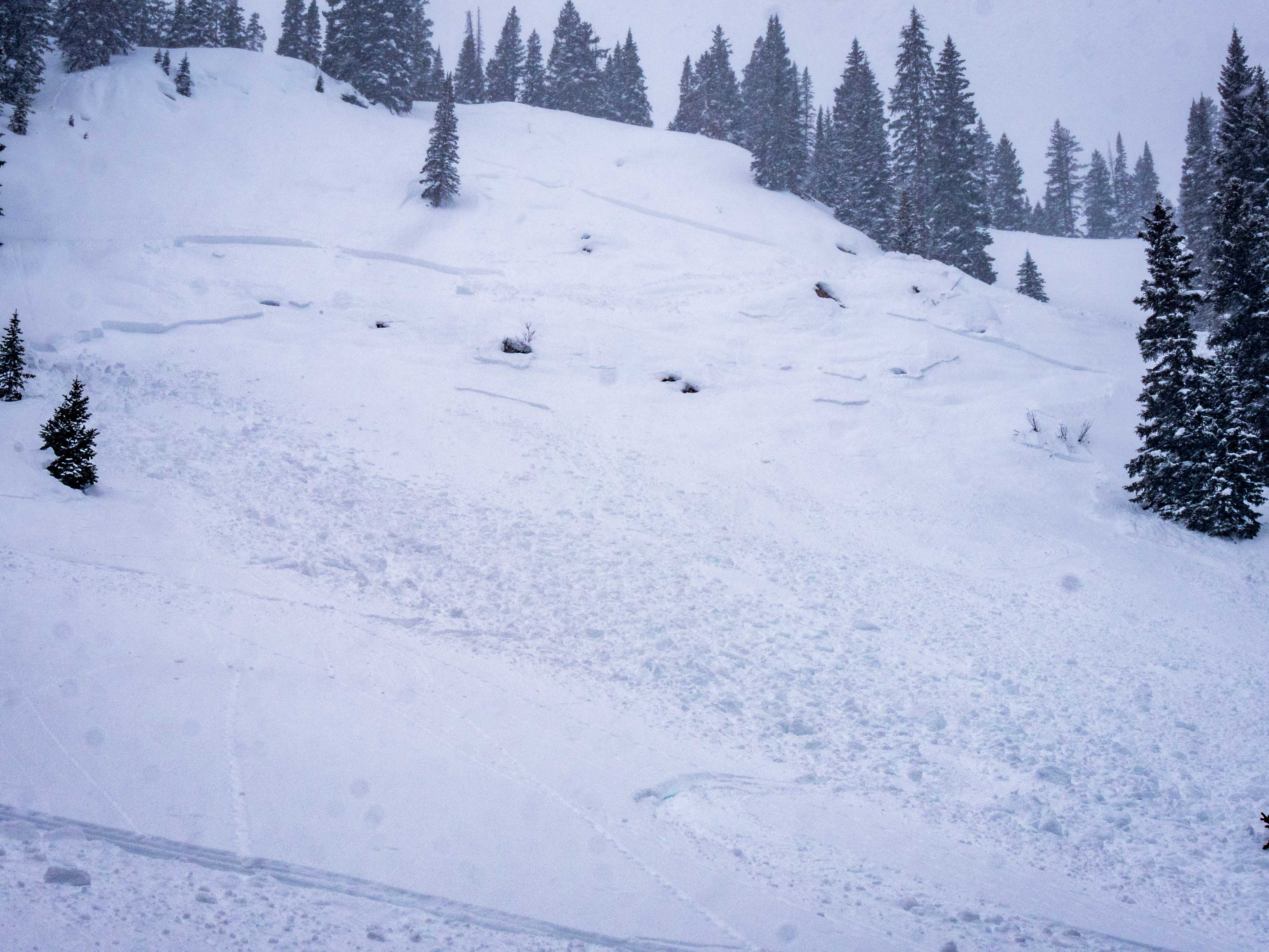
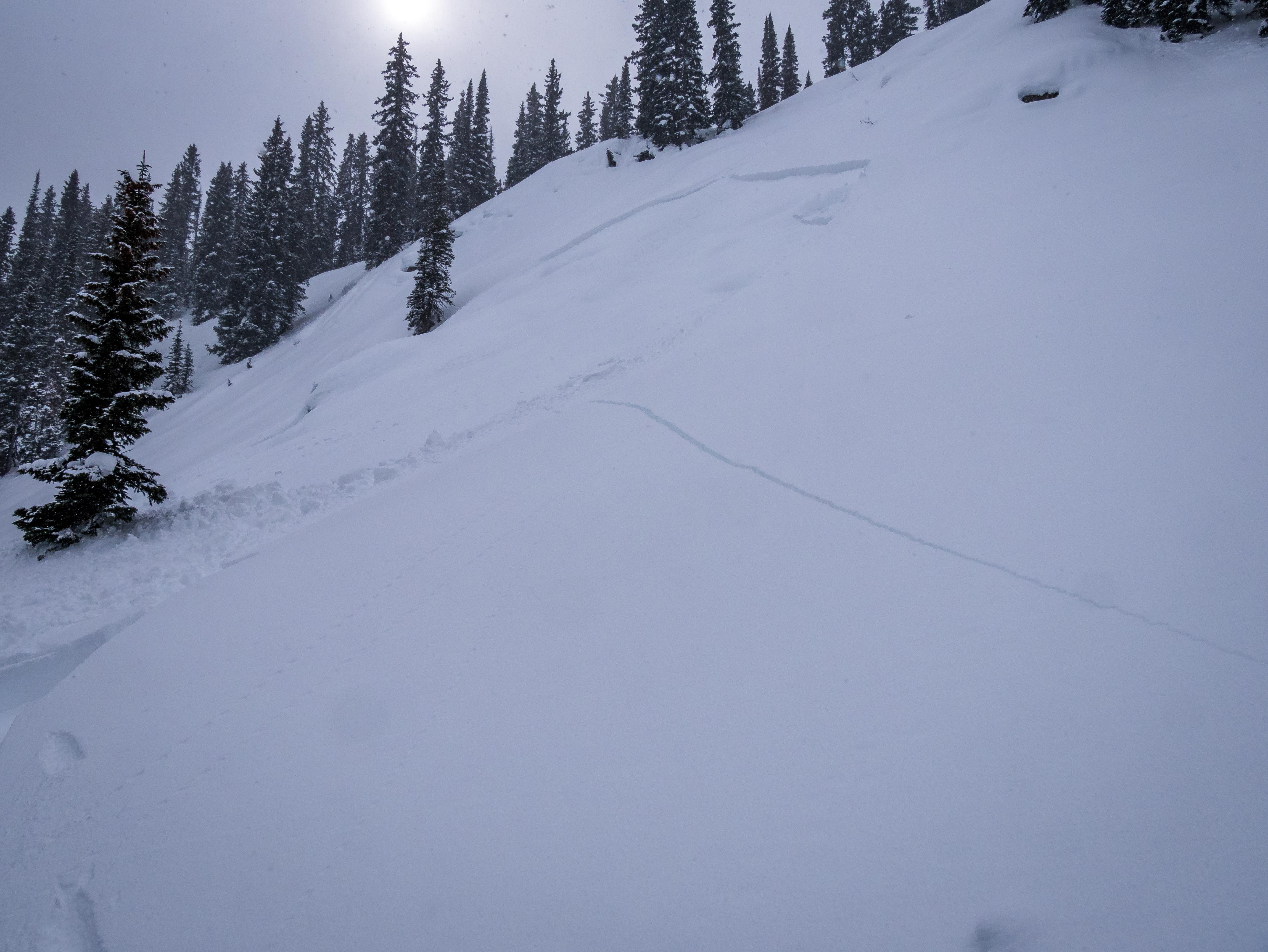
D2 – R4 observed from afar in classic climax chute repeat offender. Seems to be a natural.
Seems to have run on New snow with significant propagation across path, breaking mid slope.

Weather: Light to moderate winds as ascended out of valley flowing from W-N. Warm day, Lower 20s with light cloud coverage.

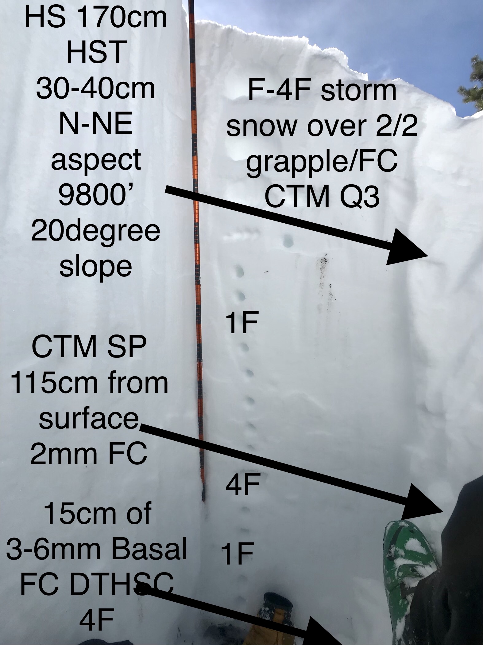
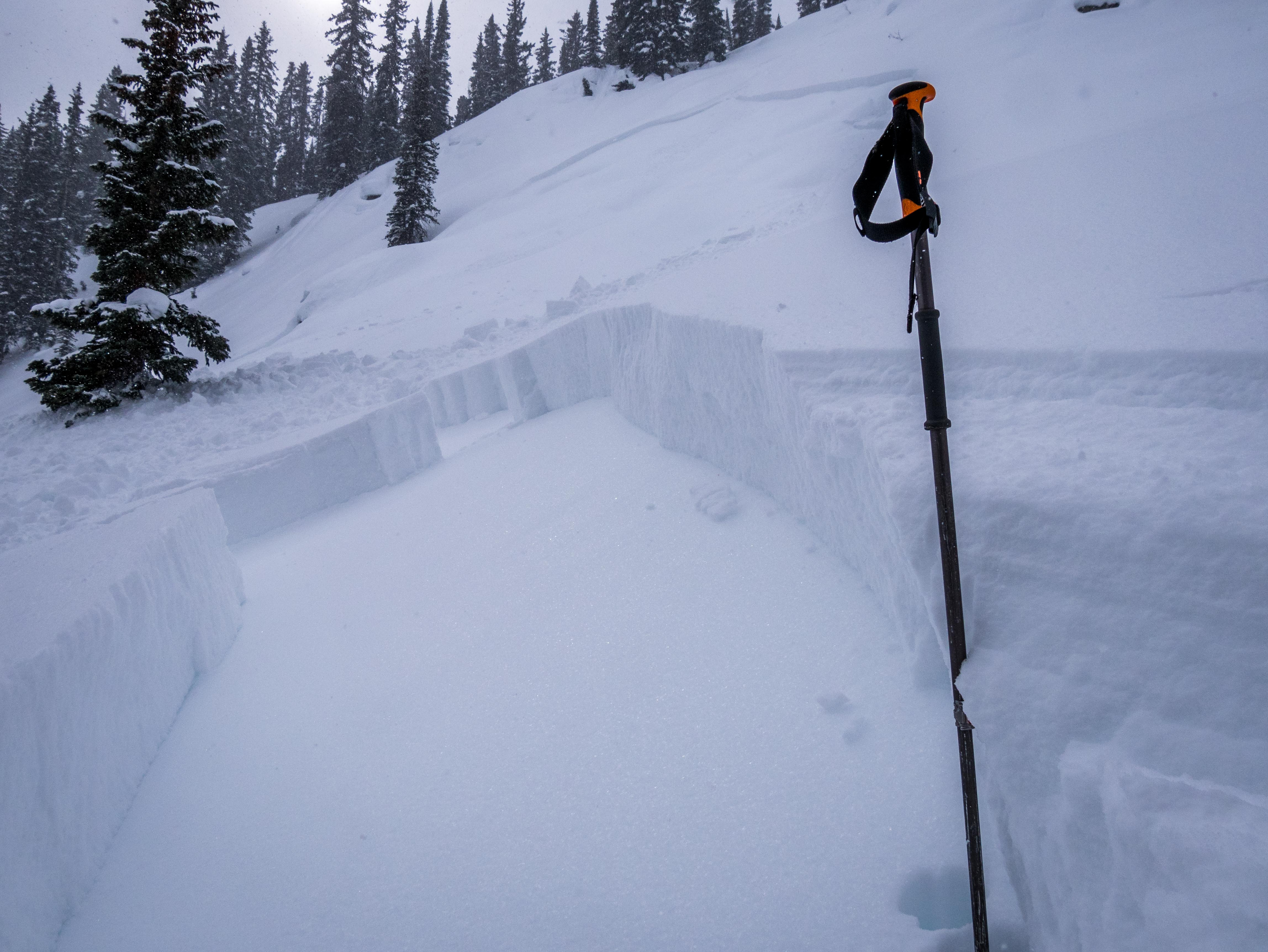
Snowpack: HS 150-170cm
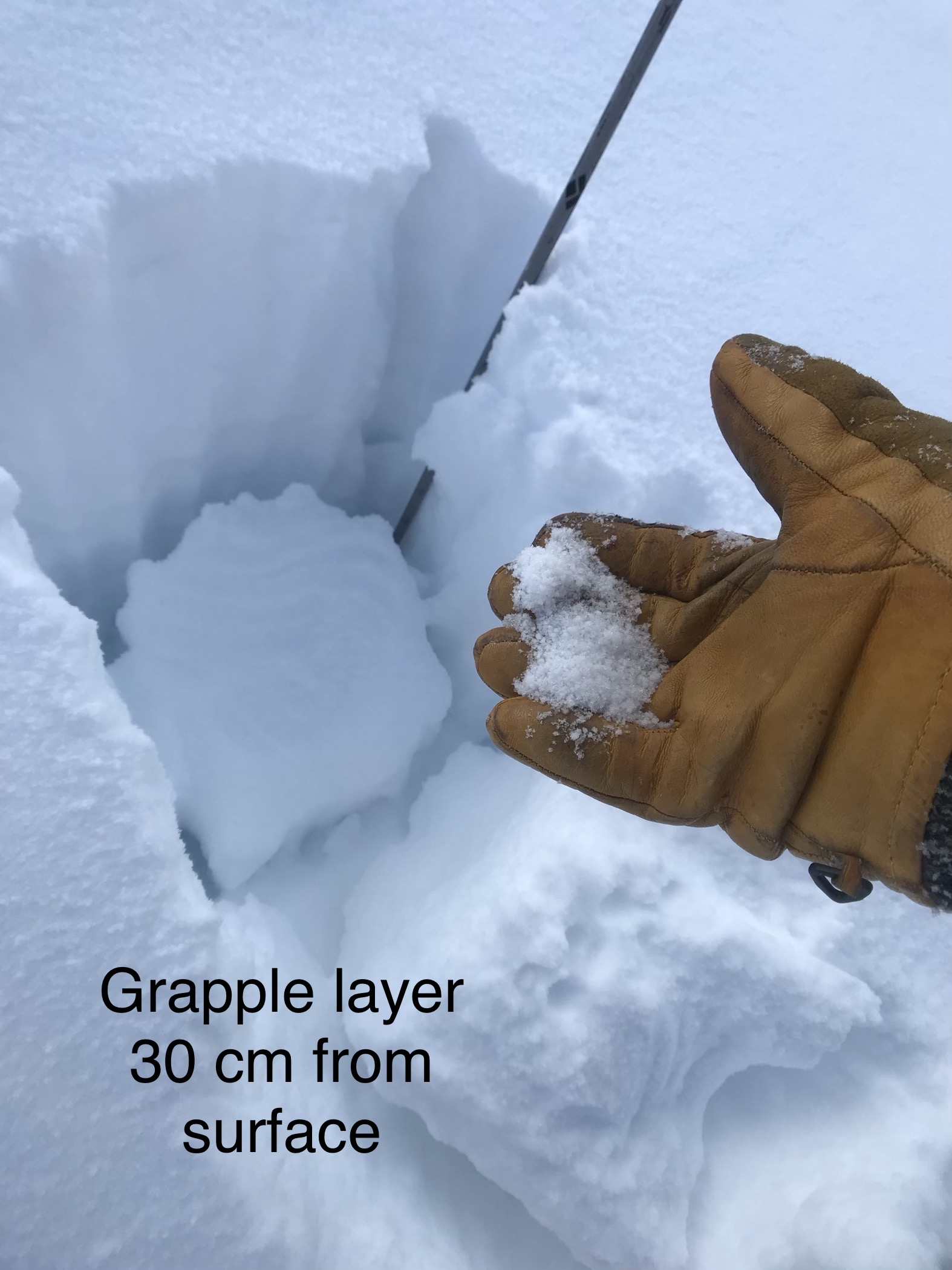
HST 30-40cm
Graupel layer 30-40 cm from surface consistent from lower elevations on up to pit site at 9800′. CTM PC. Seems to be settling out. This layer is present all around the zone form 2/3 grapple event?
Reactive layer 110 from surface to small column tests CTH SP
Basal Facets Very large in size with consolidation level at 4F reacting to small column tests DTH SC.
ECTX.

Spooky layers in depths of snowpack. With these present it’ll be a while till we’re stepping on steeper north slopes. These layers

See photo.
Photos:

Mountain Weather for 11,000ft

CB Avalanche CenterWeather

Date: 02/12/2019

The snowfall from yesterday was a bit disappointing with only 1 to 3″ across the range. Skies are currently clear and will be for the first half of the day, but high clouds will build throughout the day in front of an approaching snow maker. Beginning Wednesday evening expect wet and unsettled weather to impact the area through the weekend. It is too early to start throwing out snow totals for this period, but things are looking pretty good. A significant low-pressure system is sitting out in the Pacific Ocean with a big fetch of moisture and will a bit of luck the ‘fire hose’ will point at the central mountains of Colorado. By tomorrow morning we will be able to start attaching some numbers to this impressive, moisture-rich storm.

  • Today

    High Temperature: 19 to 24
    Winds/Direction: 8 to 18, WSW
    Sky Cover: Mostly Clear
    Irwin Snow: 0
    Elkton Snow: 0
    Friend’s Hut Snow: 0

  • Tonight

    Low Temperature: 4 to 9
    Winds/Direction: 4 to 14, W
    Sky Cover: Partly Cloudy
    Irwin Snow: 0
    Elkton Snow: 0
    Friend’s Hut Snow: 0

  • Tomorrow

    High Temperature: 25 to 30
    Winds/Direction: 12 to 22, SW
    Sky Cover: Mostly Cloudy
    Irwin Snow: 0 to 2″, evening
    Elkton Snow: 0 to 2″, evening
    Friend’s Hut Snow: 0 to 2,” evening

Long Lake activity

CB Avalanche Center2018-19 Observations

Location: Crested Butte Area
Date of Observation: 02/11/2019
Name: Zach Kinler and Eric Murrow

Subject: Long Lake activity
Aspect: North East, East
Elevation: 9,000-10,200

Avalanches:

No new avalanches observed.

Weather: Blustery and cold @ 11:00 with light to moderate winds at valley floor,16F, Broken skies. After frontal passage, skies cleared and temps warmed a bit with pleasant conditions in the trees.

Snowpack: Visited a D2 avalanche that failed around the 1/16-1/18 loading event. Bed surface was filled in with ~40 cm of F hard snow. HS near crown 130cm. This avalanche failed in an open East facing slope below tree line and propagated into sparse aspens and pines. The crown was ~ 60cm deep across the slope and bed surface was a 1.5cm crust 33 cm above the ground that likely formed after a warm dry spell in mid December left a crust on top of weak snow from Nov and early Dec . Below the crust was 3 mm F-4F- Depth Hoar/Faceted Crystals.

In the shallower zones with HS below 150 cm such as this area, the snowpack has old, well developed faceted snow, 4f hard, at the ground from Thanksgiving storms and a cohesive 1f slab resting above.  Mid-January (1/15) weak layer and 2/2 interface will be players during upcoming loading event as well as basal layers if loading comes slow and steady.  Test results were ECTN on 2/2 and ECTX.

Old bed surfaces from January avalanche cycles will come to life relatively early in the next loading event.  Snow from MLK week snow and 2/2-2/7 snow that filled in this bed surface is losing cohesion and faceting – will not accept much of a load before failing again.

Photos:

skier triggered avalanches

CB Avalanche Center2018-19 Observations

Location: Kebler Pass Area
Date of Observation: 02/11/2019
Name: MR

Subject: skier triggered avalanches
Aspect: North East, East
Elevation: 10,000-10,500

Avalanches:

I skier triggered R2.5D1.5 slide, would guess 150 feet wide, ENE aspect at around 10,400 feet Kebler/Town zone, trigger point probably right around 35 degrees, ran full track through sub 30 degree terrain, maybe 400 feet, running across a road cut and stopping at drainage bottom. We had witnessed one other skier triggered slide earlier in the day, R1.5D1, from another party, and thought we were moving to mellower terrain.
We discussed the reality that we were still skiing through an obvious start zone, but felt that the terrain was mellow enough that any instabilities would be localized in nature. The terrain did have a convexity on top that pushed just over 35 degrees but the rest of the terrain looked to be sub 30 degree. I was the first skier to drop. Just after skiing through the convexity in question, and noteworthy to say right when I felt like I had gotten past the potential trigger point, I saw the snow fracture in all directions under my feet. I immediately started traversing to my left toward my known safe zone. The snow was moving slowly and I didn’t feel all that endangered but I was surprised that as I traversed left the snow continued to fracture all around me and it took longer to get to my safe zone than I anticipated. Everything was still moving slowly when I got onto non-moving snow.
The slide continued over a second convexity, gaining momentum, and ended up running full track with speed and propagating to the left and right and developing a powder cloud. The avalanche ran through small trees but did not damage them, and we estimated the deposition pile to be around 3 feet deep as estimated on the road cut. Unfortunately I didn’t take the time to measure crown heights but from photos and memory would estimate to be between 6-18″. We do not believe it would have been deep enough to fully bury someone, but it ran fast enough to potentially cause serious injury in the handful of small trees it ran through at the bottom.
While we recognized and discussed the red flags we had already seen, we thought we were moving into manageable terrain. We obviously underestimated the potential for propagation and energy. See photos.

Weather:

Snowpack:
Photos:

Mountain Weather for 11,000ft

CB Avalanche CenterWeather

Date: 02/11/2019

The current system showed up a bit late this morning with snowfall just starting to the west of Crested Butte around 4 am. This storm still looks to drop a few inches across the forecast area but snow totals are looking meager with 2 to 5 inches expected. Snowfall looks to taper off by noon today. Tuesday into Wednesday morning is looking dry with the next approaching system arriving on Wednesday night. Expect several days of wet and unsettled weather lasting through the weekend. Meteorologists have been using the “atmospheric river” term for the upcoming stormy period, but they have low confidence as the model runs are not consistent. Keep your fingers crossed that things will line up for the Crested Butte area to get hammered by snow later this week.

  • Today

    High Temperature: 11 to 16
    Winds/Direction: 12 to 22, W
    Sky Cover: Mostly Cloudy
    Irwin Snow: 3 to 5″
    Elkton Snow: 3 to 5″
    Friend’s Hut Snow: 2 to 4″

  • Tonight

    Low Temperature: -5 to 0
    Winds/Direction: 10 to 20, W
    Sky Cover: Mostly Clear
    Irwin Snow: 0
    Elkton Snow: 0
    Friend’s Hut Snow: 0

  • Tomorrow

    High Temperature: 19 to 24
    Winds/Direction: 13 to 23, SW
    Sky Cover: Mostly Clear
    Irwin Snow: 0
    Elkton Snow: 0
    Friend’s Hut Snow: 0

Near and above treeline west faces

CB Avalanche Center2018-19 Observations

Location: Kebler Pass Area
Date of Observation: 02/10/2019
Name: Eric Murrow

Subject: Near and above treeline west faces
Aspect: North, North East, East, South East, South, South West, West, North West
Elevation:

Avalanches:

Two unobserved avalanches. one small slab in Axtel 2nd bowl apron, and another on drifted east facing ridge below treeline near Bracken Creek on north side of Anthracite Range.

Weather: Clear skies with moderate to strong gusts near and above treeline. Plumes and light loading from southerly winds periodically from highest terrain.

Snowpack: Took a tour out the Kebler Pass area looking at snow volumes on west-facing terrain to identify how much snow from the last storm stuck around from the prolonged SW winds earlier in the week. Found the most west facing upper elevation slopes were blown out and hammered by the wind. Very little evidence of avalanche activity on westerly slopes – may have been a few small slides but crowns were buffed over and debris was covered over. Suspected crowns were likely from the loading period in the second half of January, not the recent February storm.

Photos:

Pittsburg

CB Avalanche Center2018-19 Observations

Location: Paradise Divide Area
Date of Observation: 02/10/2019
Name: Joey Carpenter

Subject: Pittsburg
Aspect: North East, East, South East
Elevation: 9200-10600

Avalanches:

Large natural R3D2.5 in east facing alpine terrain of redwell. Estimates, observed from road. Likely ran during storm cycle.

3x R1D2 naturals on the E face of schuylkill mountains eastern ridge line. Viewed from basin, likely ran during storm cycle.

Weather: Bluebird and beautiful. Single digit temps at trailhead quickly rose into the twenties with strong sun. Light breeze kept surfaces cool.

Snowpack: Yesterday evenings strong wind event packed available snow into stiff but stubborn windslabs even in lower elevation bands. We were not able to trigger any on steep, small test slopes. Their presence was obvious though.
Photos:

Snodrass tour

CB Avalanche Center2018-19 Observations

Location: Crested Butte Area
Date of Observation: 02/10/2019
Name: Avy 2 – Dave Bum

Subject: Snodrass tour
Aspect: North East, East
Elevation: 10,301

Avalanches:

Did not see any Avalanches or signs of instability throughout our tour.

Weather: Temp: -6c
Wind: Calm
Sky: Clear
Precip: None

Snowpack: Pit 1:
Aspect: E
Elevation: 10:300
Incline: 30
HS: 135cm
ECTX
Snowpack was right side up till the (Fist) DH/facets 115cm down 20cm of facets to the ground. None reactive on that interface.

Pit 2:
Aspect: E
Elevation: 10:280
Incline: 30
HS: 150cm
ECTX
CT23 Brk 40cm down, Interface of the last storm snow.
Snowpack was right side up till the (Fist) DH/facets 120cm down 30cm of facets to the ground. Got a CT31+ on this layer
Photos:

Mountain Weather for 11,000ft

CB Avalanche CenterWeather

Date: 02/10/2019

Last night a quick moving short-wave passed through the area dropping little more than a few flakes but brought some gusty winds. Today will start out mostly clear with moderate to strong SW winds ahead of the next approaching system. Clouds will be on the increase throughout the day with snow beginning in earnest after midnight as a cold front passes through. There could be up to 5 inches for the snow favored areas to the west and north of town. The snow should finish by the middle of the day on Monday. Starting on Wednesday it looks like an active pattern will set up for the area with the possibility of significant accumulations through the weekend.

  • Today

    High Temperature: 20 to 25
    Winds/Direction: 10 to 20, SW
    Sky Cover: Partly Cloudy
    Irwin Snow: 0
    Elkton Snow: 0
    Friend’s Hut Snow: 0

  • Tonight

    Low Temperature: 3 to 8
    Winds/Direction: 13 to 20, SW
    Sky Cover: Overcast
    Irwin Snow: 2 to 4″
    Elkton Snow: 2 to 4″
    Friend’s Hut Snow: 2 to 4″

  • Tomorrow

    High Temperature: 10 to 15
    Winds/Direction: 10 to 20, W
    Sky Cover: Mostly Cloudy
    Irwin Snow: 1 to 3″
    Elkton Snow: 1 to 3″
    Friend’s Hut Snow: 1 to 3″

Maroon Gothic Avery – up to 401 riders trail

CB Avalanche Center2018-19 Observations

Location: Kebler Pass Area
Date of Observation: 02/10/2019
Name: Chris Martin

Subject: Maroon Gothic Avery – up to 401 riders trail
Aspect: South West, West
Elevation: 9800′

Avalanches:

N/O

Weather: OVC All day
winds out of SW-W
Low winds throughout the day becoming intense from 4-6pm
Beautiful alpen glow on Mt Cb observed at 1835
TAir around -5C midday
Tsurf -8

Snowpack: No direct signs of instability.
Strong mid pack, supportive.
Shallower snowpack observed in this eastern part of the zone.
Strong snow observed over a weak structure at the base of the snowpack. The depth hoar at the base showed no signs of instability where we were and was on its trend towards healing and consolidation.
P Slab structure identified but unreactive to large column tests. A significant layer of instability was observed 75 cm down consisting of 1mm FC/Cr combo. Sudden results on Cts and no results upon Ects. One PST test executed on FC layer 75cm down PST 40/11 arr.
Photos: