Coneys

CB Avalanche Center2018-19 Observations

Location: Crested Butte Area
Date of Observation: 02/09/2019
Name: Avy 2 – Dave Bum

Subject: Coneys
Aspect: North East, East
Elevation: 10,445

Avalanches:

Viewed multiple old avalanches (4+ days?) on NE/E aspects below tree line

Weather: Temp: -4.5C
Wind: Calm
Sky: Overcast
Precip: None

Viewed wind loading in the Alpine througout our tour

Snowpack: HS: 185cm-195cm
Multiple Hard results on CTH tests Brk 35cm down from the surface
ECTN on same layer at CT Test
Old interface of Facets to midpack 140cm down still posed concern. Facets seemed to be gaining strength (4F) but still seem to be a concern .

Was a bit surprised of how un-reactive the snow was
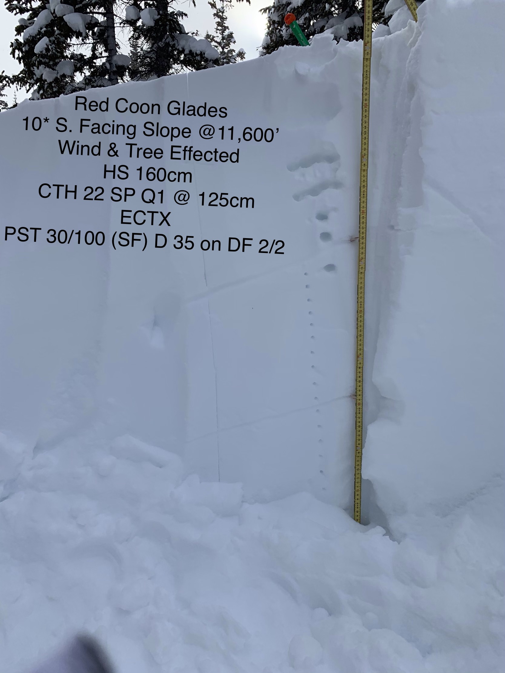
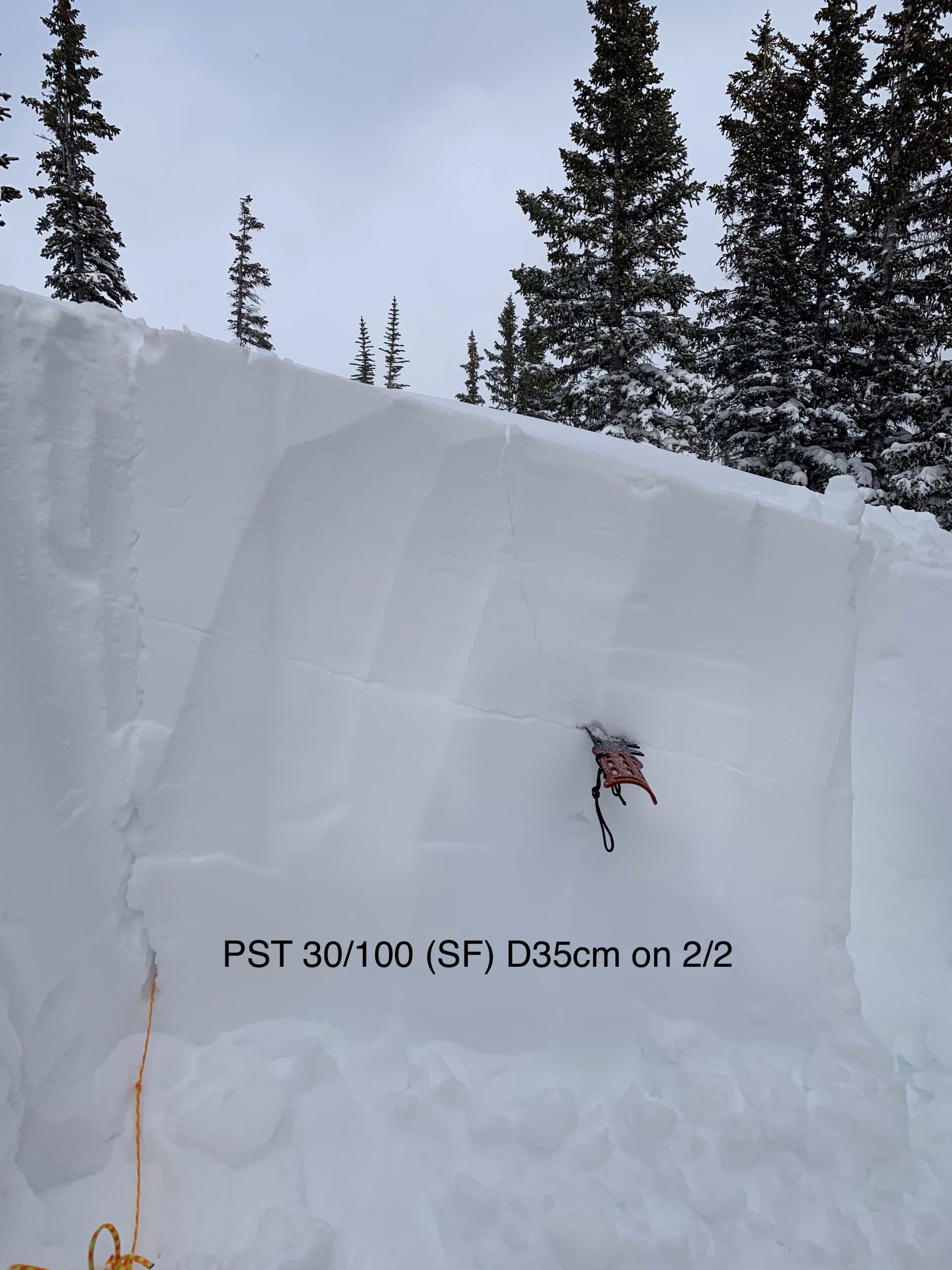
Photos:

Red Coon Glades Observation

CB Avalanche Center2018-19 Observations

Location: Crested Butte Area
Date of Observation: 02/10/2019
Name: Chris Benson

Subject: Red Coon Glades Observation
Aspect: South East
Elevation: 11,300′

Avalanches:

No cracking. Our party observed one small collapse however we followed a pre-existing skin track for the majority of the climb.

Weather: Overcast. Moderate SW winds. No significant ridge-top wind transport.

Snowpack: Top of Red Coon Glades. SSE aspect 11,300′ 25slope
Hs 165 cm, Hst 30cm, PF 40 cm, PS 20cm
Small and large column tests did not show results. CTN (x2), ECTX. While the upper snowpack did not produce results, a crust-facet-crust comb down 75 cm produced DTH SC (x2). This same interface also produced PST 45/100 End down 75cm.
Photos:

Snodgrass-quiet

CB Avalanche Center2018-19 Observations

Location: Crested Butte Area
Date of Observation: 02/09/2019
Name: ADB

Subject: Snodgrass-quiet
Aspect: North East, East
Elevation: BTL

Avalanches:

Weather: Obstructed skies and calm.

Snowpack: No cracking or collapsing on skin track out of Gothic. Snow felt very supportive and stable. Top 8 inches of snow is dense like Sierra but not deep like that snowpack. Poked ski pole down and couldn’t poke past the 8 inches of new snow from this week’s storm cycle.
Photos:

Mountain Weather for 11,000ft

CB Avalanche CenterWeather

Date: 02/09/2019

Another brisk start to the morning will gradually give way to increasing clouds and ridgetop winds as our next round of snowfall moves across the Great Basin today and should impact our area with light snow around sunset and into the overnight hours across the higher, westerly terrain. 1-4” snow expected with this moisture starved disturbance, however, this system will be quickly followed by a clipping cold front dropping out of the northwest, giving another shot of snow late Sunday, into Monday and an additional 2-4″ look possible.

  • Today

    High Temperature: 20-25
    Winds/Direction: 10-20/SW G40s
    Sky Cover: Increasing clouds
    Irwin Snow: 0″ PM
    Elkton Snow: 0″ PM
    Friend’s Hut Snow: 0″ PM

  • Tonight

    Low Temperature: -5 to 0
    Winds/Direction: 10-20/WSW G40s
    Sky Cover: Mostly Cloudy
    Irwin Snow: 1-3″
    Elkton Snow: 1-3″
    Friend’s Hut Snow: 1-3″

  • Tomorrow

    High Temperature: 22-27
    Winds/Direction: 10-20/WSW
    Sky Cover: Mostly Cloudy
    Irwin Snow: 0″
    Elkton Snow: 0″
    Friend’s Hut Snow: 0″

Natural activity from early Feb. storm

CB Avalanche Center2018-19 Observations

Location: Crested Butte Area
Date of Observation: 02/08/2019
Name: Eric Murrow

Subject: Natural activity from early Feb. storm
Aspect: North, North East, East, South East
Elevation:

Avalanches:

Avalanche activity was centered around near and above treeline slopes ( wind was key to this cycle) on north through southeast facing slopes. See photos below for a sampling of activity.

Weather: Clear day for a windshield and snowmobile tour of the greater area.

Snowpack: Only obs are from Cement Creek. Took drive around CB for pics and then ran snowmo out Cement Creek for a quick look around. Valley bottom near Hunter Creek had about 8 to 10inches of new snow, surprisingly little graupel mixed in. Near valley bottom structure was classic Persistent Slab with 1/16&1/18 snow creating a slab over weak garbage from early in the year.

Photos:

Elkton Study Plot visit

CB Avalanche Center2018-19 Observations

Location: Paradise Divide Area
Date of Observation: 02/07/2019
Name: Zach Kinler

Subject: Elkton Study Plot visit
Aspect: North East, East
Elevation: 9,000-10,400

Avalanches:

On drive from CB south observed 4 x D1 on E/NE aspects BTL. One on lower Red Mountain and 3 on Gibson Ridge.

Above Long Lake, 3 x D2 E aspect BTL. These ran in previous paths from early/mid January.

Blowing snow creating near whiteout conditions limited views of most avalanche paths.

Weather: Broken skies near town, Overcast skies up valley. Cold and windy with temps in the single digits. Moderate wind at valley floor with strong winds on ridges and peaks with off and on whiteout conditions.

Snowpack: 50 cm since 2/3 at Elkton Study plot, 10,400′. HS now 180 cm at this location. Ski pen 20 cm, Boot pen 53 cm. Recent snow is right side up with stiffer 4F slab from the beginning of the cycle underneath F hard snow from second colder wave.
Photos:

Mountain Weather for 11,000ft

CB Avalanche CenterWeather

Date: 02/08/2019

A transient, fast-moving ridge of high pressure worked drier air into the Elk Mountains overnight and established some frigid inversions once again. Currently, lower elevations are sitting at -10 to -25 and ridgetops are holding tough in the single digits above zero. High pressure will be pushed eastward throughout the day before another round of snow develops late Saturday. Westerly orographics, cold temperatures, and a 100kt jet aloft will increase winds and kick to life more snow, especially across westerly snow favored areas. The unsettled pattern continues into next week, with all models showing more Pacific moisture, but disagreeing on timing and intensity at the moment…

  • Today

    High Temperature: 10-15
    Winds/Direction: 10-20/WNW
    Sky Cover: Increasing clouds
    Irwin Snow: 0
    Elkton Snow: 0
    Friend’s Hut Snow: 0

  • Tonight

    Low Temperature: 5-10
    Winds/Direction: 5-15/SW
    Sky Cover: Overcast
    Irwin Snow: 0
    Elkton Snow: 0
    Friend’s Hut Snow: 0

  • Tomorrow

    High Temperature: 20-25
    Winds/Direction: 10-20/SW G40s
    Sky Cover: Mostly Cloudy
    Irwin Snow: 1-3″ PM
    Elkton Snow: 1-3″ PM
    Friend’s Hut Snow: 0-2″ PM

BRRRR Red Coon Glades Tour

CB Avalanche Center2018-19 Observations

Location: Kebler Pass Area
Date of Observation: 02/07/2019
Name: Travis Tucker

Subject: Red Coon Glades Tour
Aspect: South East, South
Elevation: 11,600’

Avalanches:

None observed
Weather: COLD . OVC. S-1 snow, and low visibility. Moderate to Strong winds with larger gusts all day. Moderate + wind transport.

Snowpack: Wind packed snow & stubborn storm slab.
PF 30. Heavy POW.
See images for structure and stability test.

Photos:

Irwin Cat Obs

CB Avalanche Center2018-19 Observations

Location: Kebler Pass Area
Date of Observation: 02/07/2019
Name: Eleven Cat Ski Guides

Subject: Irwin Cat Obs
Aspect: East, South East, South, South West, West
Elevation: 10-12,000ft

Avalanches:

Only a few minor results from ski cuts pulling out storm slabs in Way Long & R2 below
Sunset. Overall Storm slab/wind slab was stubborn to ski cuts, but reactive to Size 1s with explosives. No
visibility to observe surrounding terrain.

Weather: Unable to gain access to ridge cat drops; extreme winds, low visibility and wind chill
values shut us down! Cold day with strong to extreme gusts and temps intensifying around 11:00 throughout
the remainder of day. Skies went to BRK at 1630.

Snowpack: Morning started out similar to yesterday, but as winds increased the storm slab
stiffened dramatically through the day. Ski quality was stiff cream cheese with wind slabs lower on slope
that would stuff the relaxed, laid back skiers. Protected terrain held the most quality. We are now riding
the slab and skier penetration is decreasing dramatically.
Avalanche observations:

Photos: