variable conditions

CB Avalanche Center2020-21 Observations

Zone: Southeast Mountains

Location: RLG

Date of Observation: 12/15/2020

Name: Kye, Marko, Owen, Finn, Ross graduating class of 2020


Subject: variable conditions

Aspect: South, South West

Elevation: 11,000 to the valley floor

Avalanches:

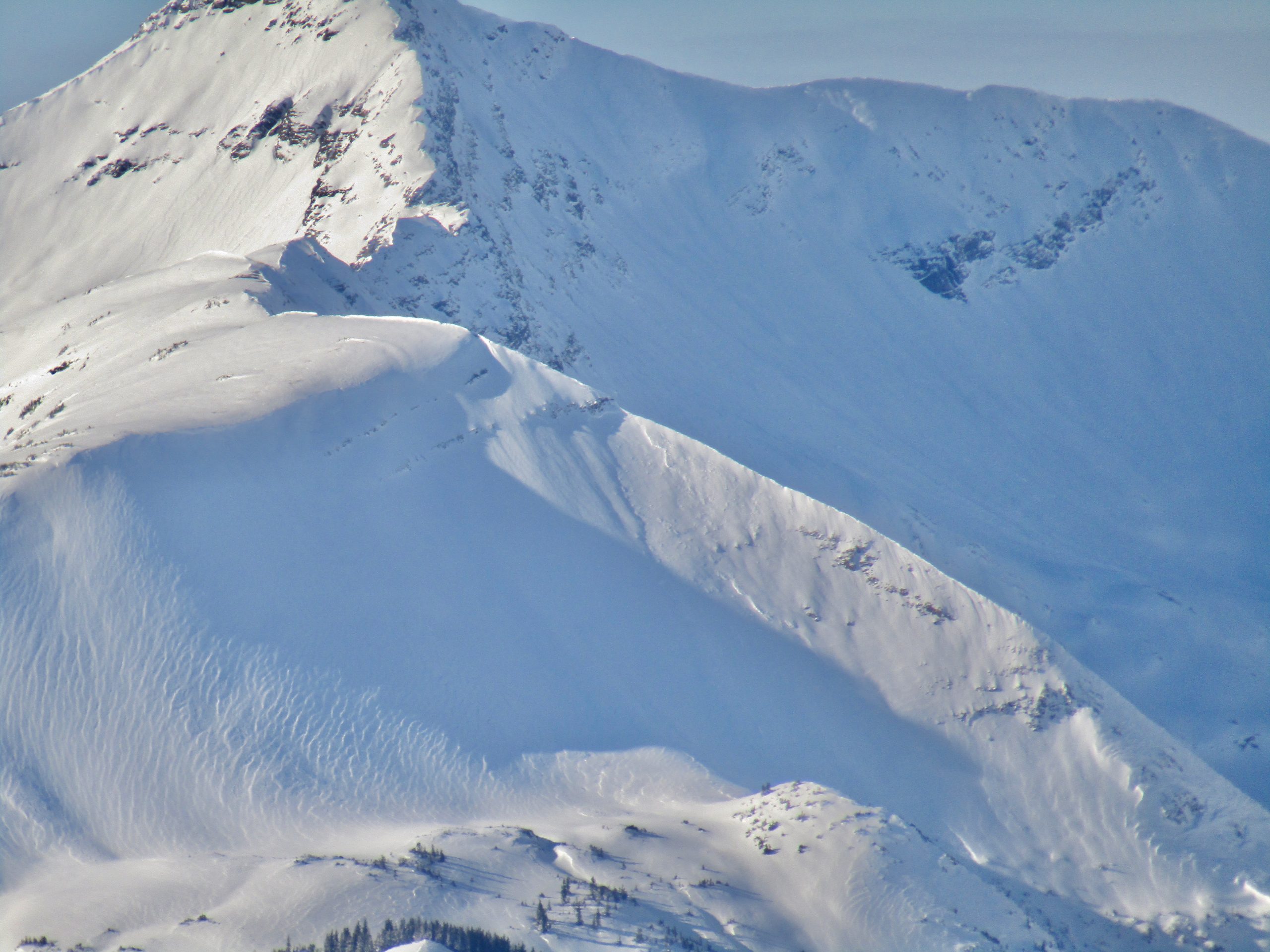
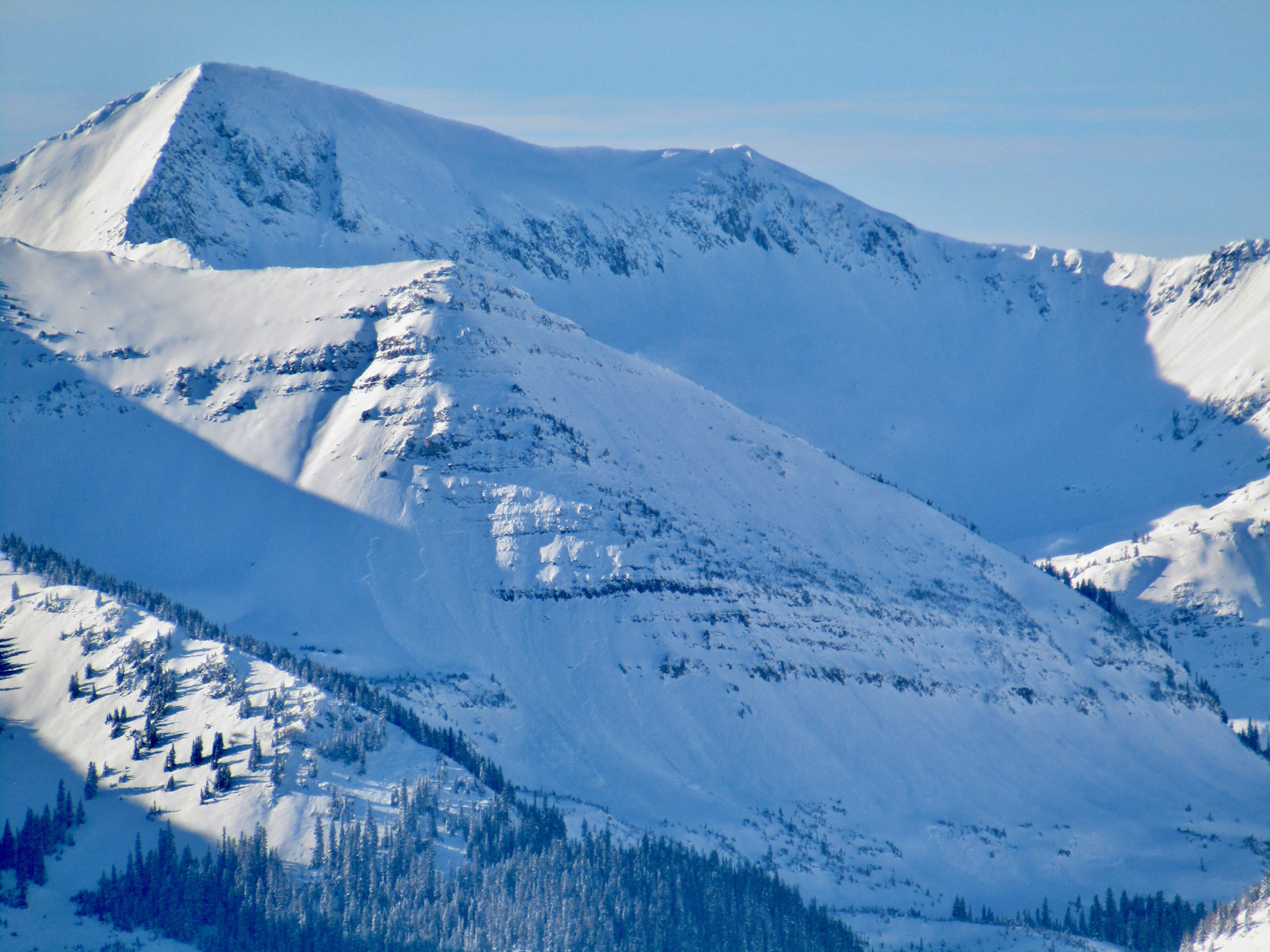
Hard to see the surrounding mountains at times due to weather but some activity was seen in the form of old crowns on steeper terrain in wind blown areas. Looks like some of these released during the last snow. No activity was observed in the RLG zone.


Weather: Cold and windy in the valley bottom. Looked like it was ripping down the valley, 20mph because winds were light at the goal posts.
Overcast and lightly snowing. The solar didn’t seem to be affecting the snow that much. Wind higher on the ridge tops looked to be transporting snow.

Snowpack: Super variable in the glades. A mixed bag of crusts, facets and new snow on top of ground. Depths ranged from 6-8 inches to 2 feet depending on elevation, aspect and wind loaded zones. Some areas had a supportable crust, while other shaded areas had facets at the ground. Lower in the fields large collapses were felt with shooting cracks observed, no movement seen due to the lack of slope angle. No avalanche activity was observed. The most dangerous part of the day was hitting obstacles. Its a mixed bag in RLG and it will be interesting to see how this pans out as we get more snow load

Crazy remote triggering

CBAC2020-21 Observations

Zone: Southeast Mountains

Location: East River

Date of Observation: 12/15/2020

Name: Zach Guy


Subject: Crazy remote triggering

Aspect: East

Elevation: 9100 – 9500′

Avalanches: Remotely triggered two small slab avalanches (about a foot thick, 20 feet wide, ran 30 to 50 feet).  One of the slides we triggered from 1200′ away! I watched the cracks connect and the feature slide in pure disbelief.  We also got a number of similar slopes to shatter with cracks and slump, but not move, mostly remotely triggered again.

Weather: Light to moderate northerly wind channeling down valley. Partly cloudy skies

Snowpack: About 10″ or so of settled storm snow over the 12/10 interface, which was decaying surface hoar on facets here. Recent and ongoing northerly winds had redistributed the snow into a patchy network of stiffer slabs (4F). We produced collapses in most areas where there was wind stiffening or loading. They seemed localized, but then we got a few collapses that produced cracking and avalanches from surprisingly long distances away. Surface hoar does some crazy things.  The slabs were small and easy to recognize, but we avoided riding above terrain traps where a small avalanche could push you into trees.

Photos:

Cement Creek snow

CB Avalanche Center2020-21 Observations

Zone: Southeast Mountains

Location: Cement creek

Date of Observation: 12/15/2020

Name: Cosmo Langsfeld

Subject: Cement Creek snow

Elevation: 9250

Weather: 3” on the ground from yesterday’s storm.

Gothic

CBAC2020-21 Observations

Zone: Southeast Mountains

Location: Gothic

Date of Observation: 12/15/2020

Name: billy barr

Subject: Gothic

Weather: Light snow much of Monday but ending at sunset and staying dry overnight with 3″ new and water 0.18″. Snowpack is at 23″. Currently mostly cloudy, calm and cool with the temp. range a high of 24F. low of 5F and the current is 11.

Remote triggered slide at Irwin

CBAC2020-21 Observations

Zone: Northwest Mountains

Location: Irwin Tenure

Date of Observation: 12/14/2020

Name: Irwin Guides

Subject: Remote triggered slide at Irwin

Avalanches: Skied the far skiers right side of lodge gully W aspect <TL and remotely triggered from 50′ away a .5 to the ground 50′ wide. SS-AS/u-D.5-G

Weather: Cold morning low of -14. Started snowing at 0700 after a clear night. Sky remained Obscure all day snowing S1/ S-1 off and on all day. Winds were Calm <TL and light out of the S >TL.

Snowpack: Snowpack has settled and become supportive. Ski pen averaged 30cm. The average HS up to 70 ridge was 50-60cm. Toured up the road system to the top of 70 down 70 gully to skin track and Lodge Gully to finish. Observed numerous collapses but nothing not to be expected or too large. Several Obs on Steeper terrain around Irwin village road cuts, etc. had cracked to the ground slumped but did not run. These occurred two days ago near the end of the storm.

Continued Obvious Signs To Instability

CBAC2020-21 Observations

Zone: Northwest Mountains
Date of Observation: 12/14/2020
Name: Evan Ross
Aspect: North, North East, West
Elevation: 11,000

Weather: Poor visibility until the weather started to clear in the late afternoon. Calm winds. Measured about 6″ of very light new snow at 11,000ft, from todays storm.

Snowpack: Spent a few hours in the afternoon traveling around 11,000ft on West, North and Northeast aspects. More of the same, shooting cracks on many of the slopes traveled. The avalanche problem was fairly obvious without having to look to hard. Conservative decision making. If you chose to travel on a steep slope, that hadn’t already avalanched, it seemed like a high likelihood it would avalanche… Got close to some bigger steep slopes wondering if they would remote trigger and didn’t see any results.

Measured about 6″ of very light new snow at 11,000ft, from todays storm. HS at 11,000ft in a well sheltered meadow was right about 100cm.

Due to traveling on lower angled slopes. The only time I saw blocks move was when they were cut up. This particular slab was about 70cm’s thick.


More Persistent Slabs

CBAC2020-21 Observations

Zone: Northwest Mountains

Location: Elk Creek Drainage off Kebler pass

Date of Observation: 12/14/2020

Name: Jack Caprio and Zach Guy


Subject: More Persistent Slabs

Aspect: North, North East, East

Elevation: 9,800′-10,500′

Avalanches:

We observed numerous persistent slab avalanches on NE and E aspects BTL, ranging from D1-D2 in size, most that ran this weekend and some that we triggered today. While skinning up a ridgeline, we crossed above 7 NE facing avalanche paths. Of those 7, 5 had already run naturally during our recent storm cycle. The remaining two were easily triggered by ski cutting convexities near the top of the start zones. The slab depths varied from 12-16 inches, encasing all the recent storm snow. As the slides picked up speed, they entrained some of the rotten snow at the bottom of the snowpack.  All of the slides propagated across their entire start zones and ran about 3/4 of the distance to the bottom of the avalanche path.  They were all soft slabs failing on the 12/10 interface.

Weather: Little to no wind. Overcast skies. The snowfall rate varied from S-1 to S2 from 12 pm – 2 pm, with a few inches of new snow throughout the day.

Snowpack: Traveled below treeline hoping to find improving stability but continue to get widespread collapses and triggered slides.  The top 12-16 inches of the snowpack consisted of F hard precipitation particles from our recent storm accumulations. Sitting below the storm snow is the 12/10 weak layer/ interface. On Northerly aspects, this interface consists of F hard buried near-surface facets. On Northeast through East facing aspects, this interface consists of a thin melt-freeze crust with near-surface facets sitting on top.


Photos:

[/gravityforms]

Just a couple more from the Ruby Range

CB Avalanche Center2020-21 Observations

Zone: Crested Butte Backcountry
Date of Observation: 12/13/2020
Name: Zach Kinler

Avalanches:

Got decent views towards the East side of the Ruby Range into alpine terrain. Numerous D1.5-D2.5 slab avalanches on slopes facing primarily E-NE with a few wrapping around onto SE aspects. Some failed early in the cycle with crowns and paths faint, while other failed later in the storm with increasing northerly winds.


[/gravityforms]

A few avalanche observations

CB Avalanche Center2020-21 Observations

Zone: Northwest Mountains

Location: Ruby Range

Date of Observation: 12/13/2020

Name: Ben Pritchett


Subject: A few avalanche observations

Aspect: North East, East

Elevation: Near and above treeline

Avalanches:

Avalanches
Date Location/Path # Elev Asp Type Trig SizeR SizeD
View 2020/12/13 † Mount Emmons 1 TL NE SS N R1 D2
View 2020/12/13 † Ruby Range 1 >TL NE SS N R2 D2
View 2020/12/13 † Ruby Range 2 TL NE SS N R2 D2
View 2020/12/13 † Ruby Range 1 TL NE SS N R1 D2
View 2020/12/13 † Ruby Range 1 >TL E SS N R1 D2

Weather:

Snowpack:

Photos: