


By Arden Feldman CBAC Intern
With a broad ridge of high pressure shifting east over the continental US, March 3rd and 4th were quite pleasant with sunny skies, light winds, and daytime high temperatures just above freezing. The next Pacific trough of low pressure began coming ashore on the 5th, briefly bringing back stormy weather. An associated cold front on the morning of the 6th brought 4 to 7 inches of new snow and cold temperatures, but the big story was the extreme westerly winds mixing down to all elevations caused by a relatively low elevation jet and a strong pressure gradient. On the morning of the 6th, winds were blowing at 60 mph and gusting to 100 mph on Scarp Ridge. On the 7th the storm track shifted northward as a high pressure began to build over the West. The high pressure lasted through the rest of the work week and brought a warming trend, calm winds and sunny skies. On the 10th, Elkton reached a high temperature of 43 degrees Fahrenheit. A pair of fast moving disturbances brought back unsettled weather on the 11th and 12th. These shortwave troughs resulted in some snow further north, but only brought increased clouds and gusty winds around the Crested Butte Area. High pressure took hold over the West again on the 13th allowing for calm and dry weather and temperatures approaching near record highs through the 15th.

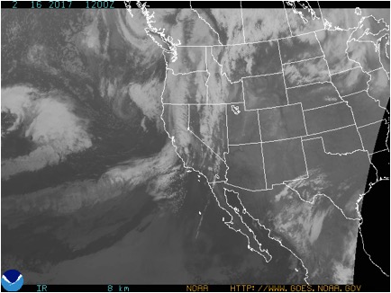
3/9/17 – Satellite image showing the first disturbance heading for Colorado.

3/13/17 – Satellite image showing the second disturbance fleeing to the east.
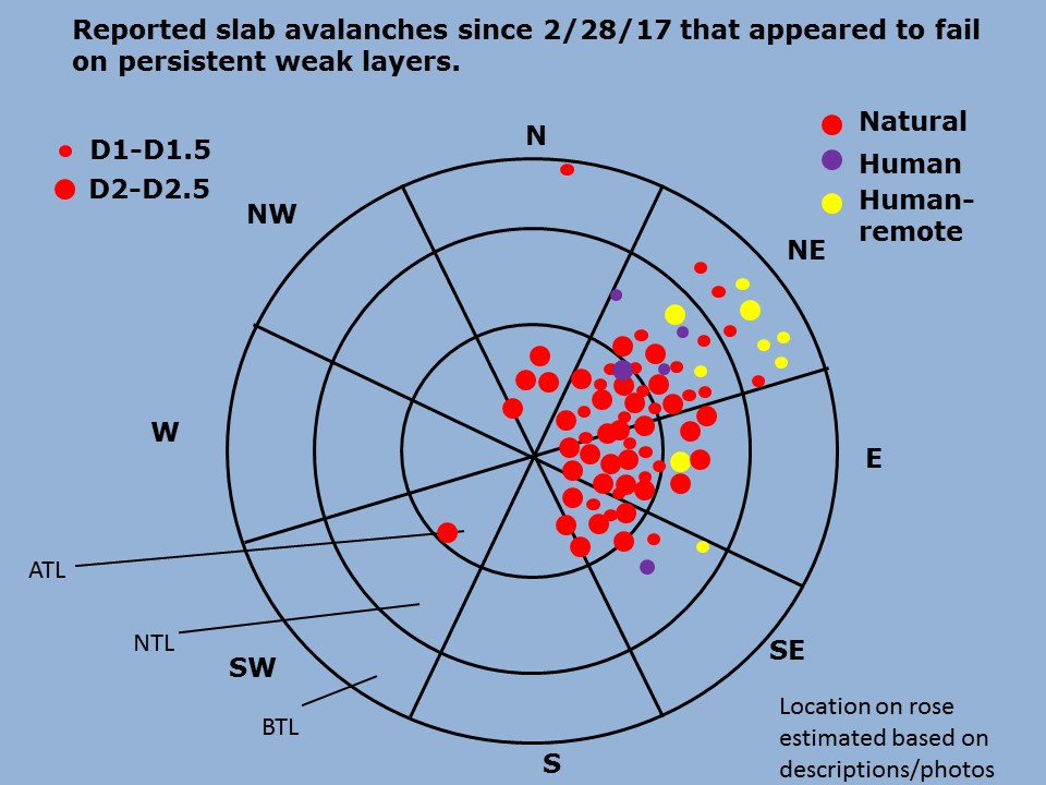
Persistent slabs 1 to 3 feet thick over facets and facet crust combos buried mid February remained an avalanche problem through the first half of March on north through southeast aspects. These slabs remained sensitive to triggers through the first week of March. The problem slowly stabilized, and the danger dropped from Considerable on March 3rd to Moderate on the 4th and 5th. The extreme wind event on the 6th added weight to the slabs and raised the danger back to Considerable for the day. Eventually, after more time to stabilize and a lull in avalanche activity, the danger dropped down to Low at all elevation bands on the 13th.

3/2/17 – Skier triggered persistent slab avalanche on a NE aspect NTL on a very thin, faceted crust.

3/2/17 – Persistent slab avalanches in Evan’s Basin.

3/2/17 – Natural D2 slab avalanche on an ENE aspect ATL.
March 3rd and 4th brought the first above freezing temperatures since the new snow on February 28th, adding loose wet avalanches to the problem list. These avalanches were small but concerning due to the potential for them to subsequently trigger larger persistent slab avalanches. Loose wet avalanches came back to the problem list on the 14th and 15th due to the near record high temperatures. They remained relatively small, but still potentially consequential.

3/14/17 – Wet slab/mud slide near Kebler Pass Road.
The extreme westerly wind event on the 6th added wind slabs to the problem list through the 8th. The wind event seemed to do more wind scouring than loading, but some spots still harbored small but dense wind slabs that would make for unpleasant surprises, especially in consequential terrain.


