Snodgrass Obs

CB Avalanche Center2019-20 Observations

Location: Crested Butte Area
Date of Observation: 12/31/2019
Subject: Snodgrass Obs
Aspect: North East
Elevation: 10,900

Avalanches: Skier Triggered a dry loose avalanche in a steep gully terrain trap on 1st bowl. Ran about 300ft downhill piling a lot of snow on the trees below

[/gravityforms]

Mountain Weather for 11,000ft. Tuesday 12/31

CB Avalanche CenterWeather

Date: 12/31/2019

It’s so cold out there that dogs are sticking to fire hydrants. Be careful out there folks. -20’s down in the valleys, oo fun. The sun will come out, and we’ll have another beautiful day. High clouds will start moving in this afternoon as we get ready for the start of the New Years Storm. We’ll be in NW flow on Wednesday and Thursday as a deep low-pressure trough builds over the western US. The snow looks to ramp up quickly, late on Wednesday afternoon. By Thursday morning we could be looking at 6 to 8” West and North of Crested Butte, and 3 to 5 in Crested Butte. Snowfall looks to continue on Thursday, mostly for the orographically favored areas again west and north of CB. Dry weather arrives to start the weekend.

  • Today

    High Temperature: 18 to 22
    Winds/Direction: 5 to 15, WNW
    Sky Cover: Mostly Clear
    Irwin Snow: 0
    Elkton Snow: 0
    Friend’s Hut Snow: 0

  • Tonight

    Low Temperature: 1 to 5
    Winds/Direction: 5 to 15, NW
    Sky Cover: Partly Cloudy
    Irwin Snow: 0
    Elkton Snow: 0
    Friend’s Hut Snow: 0

  • Tomorrow

    High Temperature: 22 to 26
    Winds/Direction: 10 to 20, WNW
    Sky Cover:
    Irwin Snow: 2 to 4 PM
    Elkton Snow: 2 to 4PM
    Friend’s Hut Snow: 1 to 2PM

Couple Of Small Skier Triggered Wind Slabs

CB Avalanche Center2019-20 Observations

Location: Crested Butte Area, Mt Emmons
Date of Observation: 12/30/2019
Name: Evan Ross
Subject: Couple Of Small Skier Triggered Wind Slabs
Aspect: North East, East, South East
Elevation: 9,200-12,000

Avalanches: Coupe of small skier triggered Wind Slabs to D1.5 with crown depth 30-40cm. SE aspect, above treeline.
Several skier triggered loose snow avalanches on NE to E to SE at NTL and BTL elevations. All small and moving slow.

Weather: Clear sky, calm wind, cold temps.

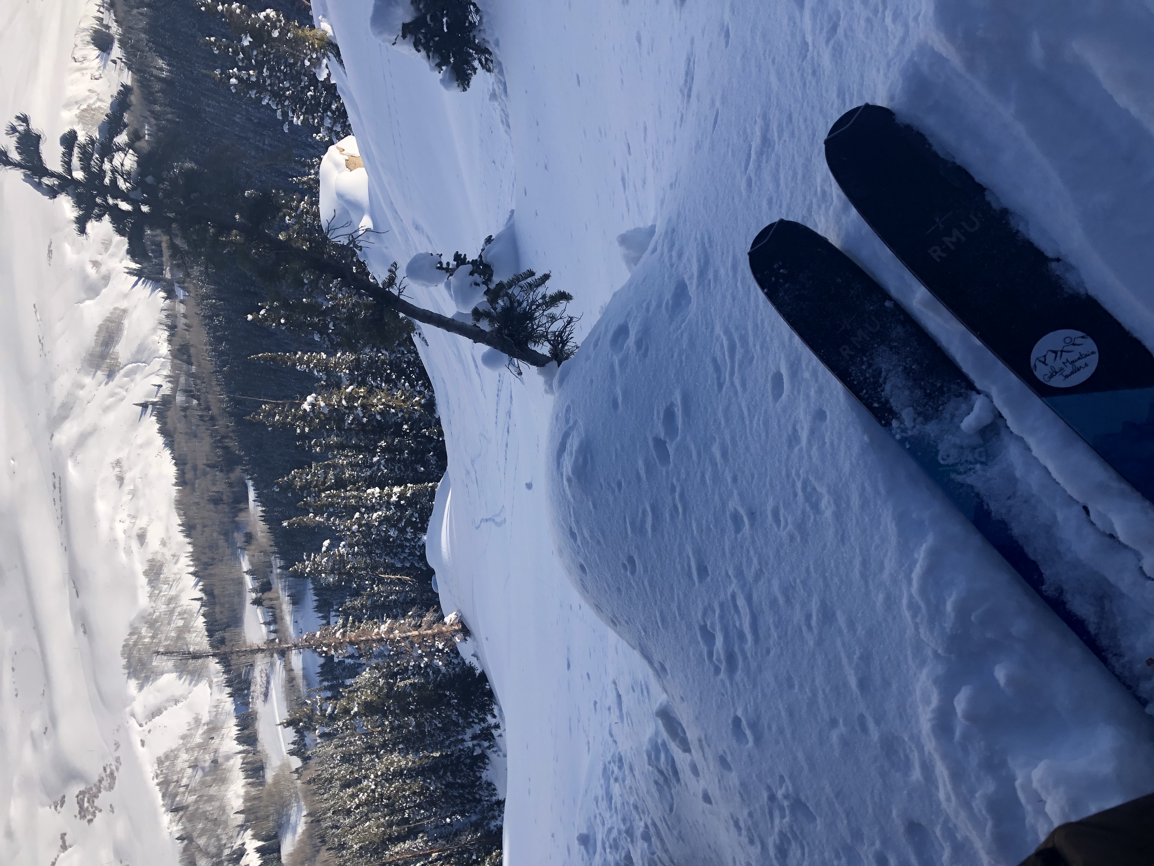
Snowpack: Wonderful ski conditions. The specific terrain that we found ourselves managing was previously wind-loaded terrain. This was were you could find the best distribution of Persistent Slab Structure and/or today’s forecasted Wind Slab Problem.

NTL SE facing slopes only had the potential for concern where they were wind-loaded. Otherwise the snowpack is generally weak and mixed with crusts. In this terrain, the 12/26 thin crust may be the first to collapse into the 12/24. Though there are several layers of concern in the snowpack. A decent load and a new slab will need to happen to see the PSa problem expand and become widespread on this aspect. 1.5 SWE, or closer to 1.2 SWE in a quick loading event.

NE NTL/BTL elevations were weak and not concerning for a slab avalanche problem in this terrain. HS was about 90cm. A few skier triggered sluffs, but they were stubborn, slow, and easy to manage.

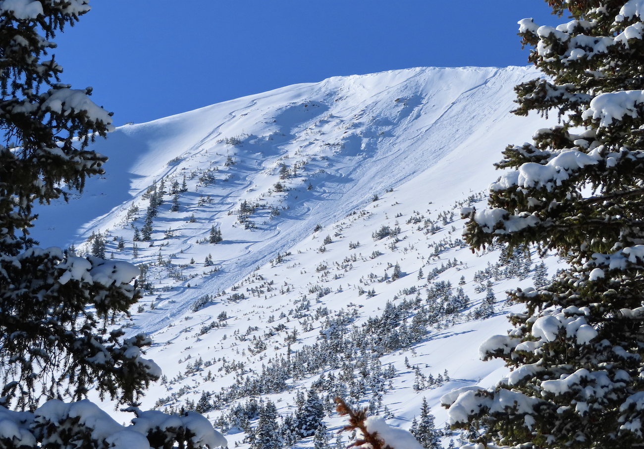
Couple of small Wind Slab Avalanches on an East to Southeast facing slope above treeline.

Mountain Weather for 11,000ft Monday, December 30th

CB Avalanche CenterWeather

Date: 12/30/2019

Yikes…..-30 in Crested Butte this morning. Temperatures hit the coldest of the year last night ranging from -30 to -single digits. Today will be sunny which should help to make it feel warmer than the nasty air temperatures suggest. Winds look to remain light which unfortunately will not help displace any of the cold air pooling in valley bottoms. If you are able to get out of valley bottoms today, the high temperatures will feel reasonable, but the lowest terrain will struggle to reach much above 0. Be sure to manage your finger, toes, and noses to prevent cold injury.

Now for the good news…a series of disturbances will begin impacting the area on Wednesday afternoon and produce snowfall through Friday. It still a bit early to get too excited but moisture looks ample coupled with a strong jet stream to support good snow production. Time will tell but it looks like 2020 is going to get rolling with a snowy start.

  • Today

    High Temperature: 12 to 16
    Winds/Direction: 3 to 13, NW
    Sky Cover: Mostly Clear
    Irwin Snow: 0
    Elkton Snow: 0
    Friend’s Hut Snow: 0

  • Tonight

    Low Temperature: -3 to -7
    Winds/Direction: 3 to 13, N
    Sky Cover: Clear
    Irwin Snow: 0
    Elkton Snow: 0
    Friend’s Hut Snow: 0

  • Tomorrow

    High Temperature: 19 to 23
    Winds/Direction: 4 to 14, WNW
    Sky Cover: Clear
    Irwin Snow: 0
    Elkton Snow: 0
    Friend’s Hut Snow: 0

Snow favored area – slab check

CB Avalanche Center2019-20 Observations

Location: Paradise Divide Area
Date of Observation: 12/29/2019
Name: Eric Murrow

Subject: Snow favored area – slab check

Aspect: North East, East, South East

Elevation: 9400′ – 11000′

Avalanches:  Lots of old sluffs that ran several days ago with a few inches of new on top of debris. A handful of windslabs on drifted terrain features E,S,SW. Did not observe any deep or basal weak layer avalanches.

Weather: yup, it was cold! Partly cloudy skies. Light north winds were stacking low cloud cover onto the Ruby Range. Visibility into this terrain was reasonable but often obscured. Observed light transport at upper elevations onto southerly aspects.

Snowpack: Below treeline, in this snow favored area, I was checking on the recent Santa storm to see if it had settled or slabbed up much….it has not. Storm snow since 12/24 was in the 30 to 40cm range throughout Washington Gulch. Immediately beneath the Santa storm is a thin layer of 1mm near surface facets that formed from the dry spell in the middle of December. This layer is obvious in pit walls and produced results in hand sheer and CT’s but because it remains so soft – no propagating test results from profile site. Cold temperatures will likely prevent the Santa storm from becoming cohesive in the short term at sheltered locations; if you could find a location that saw a bit of drifting maybe there could be more cohesion and increased slab avalanche hazard. See photo of profile.

Photos:

Moving Through Terrain

CB Avalanche Center2019-20 Observations

Location: Paradise Divide Area
Date of Observation: 12/29/2019
Name: Evan Ross
Subject: Moving Through Terrain
Aspect: North, East, South, West
Elevation: 9,500-12,000

Avalanches: Triggered one 30cm slab with a cut on a 40’ish degree slope above a creek. This was a southerly facing slope, but given its low elevation in the valley bottom it was more sheltered from the sun. The weak layer was the 12/24 NSF. The same concerning weak layer also found higher in the terrain on northerly and easterly facing slopes.

Lots of potentially fresh looking avalanches. With more time looking at those, they still appear to be the old slabs from the last major natural cycle a couple weeks ago. A foot of new snow doesn’t necessarily cover up 3 foot deep crowns that well. So at times they look fresh from a distance, but then you cant find the fresh avalanche debris too. The fresh avalanches were recent windslabs to D2, and many loose dry avalanches that are now a day or a couple days old. As far as recent Persistent Slab Avalanches, it’s really hard to say. At the moment I can’t say that I saw anything substantial on that front.

Weather: Cold, check. Observed snow blowing at NTL elevations from westerly winds. Few clouds through most of the day with a thicker low cloud bank moving over the ruby range in the late afternoon.

Snowpack: Moved through a lot of terrain. Mostly in the mid-30-degree range and lower. Got on some steeper slopes but they were more “test slope” size. Touched almost all the aspects. To sum it all up briefly. Slope cuts on wind-loaded terrain NTL and BTL southerly slopes produced no results. Traveling on all the other slopes didn’t show any obvious signs of instability. The most concerning snowpack observation, was the recent snow sitting on the 12/24 NSF. The 30 to 40cm slab above was maybe to soft to produce results in the terrain I traveled? Or I couldn’t test it enough on slopes that where steep enough. Other then the one small triggered slab.

Mountain Weather for 11,000ft Sunday, December 29th

CB Avalanche CenterWeather

Date: 12/29/2019

The snow producing system from the past few days has pushed eastward into the Great Plains, which has left the Crested Butte area under a very cold north flow. A tiny bit of residual moisture is leftover and may create a few flurries for the highest terrain to the north and west of Crested Butte but should dissipate by midday. The big story for the next few days will be the very cold temperatures. Daytime highs will struggle to reach double digits and, at many locations, may only reach just above 0. Temperatures will warm each day through Wednesday which is when the next significant storm should arrive. Models already are suggesting that the second half of this week will be snowy so hooray for that.

Temperatures will be cold enough to cause injury today so plan accordingly.

  • Today

    High Temperature: 5 to 10
    Winds/Direction: 8 to 18, NW
    Sky Cover: Decreasing clouds
    Irwin Snow: 0 to trace
    Elkton Snow: 0 to trace
    Friend’s Hut Snow: 0 to trace

  • Tonight

    Low Temperature: -7 to -12
    Winds/Direction: 6 to 16, NW
    Sky Cover: Mostly Clear
    Irwin Snow: 0
    Elkton Snow: 0
    Friend’s Hut Snow: 0

  • Tomorrow

    High Temperature: 13 to 18
    Winds/Direction: 2 to 12, NW
    Sky Cover: Clear
    Irwin Snow: 0
    Elkton Snow: 0
    Friend’s Hut Snow: 0

Surfing On A Soft Crust, South

CB Avalanche Center2019-20 Observations

Location: Mt Emmons
Date of Observation: 12/28/2019
Name: Evan Ross
Subject: Surfing On A Soft Crust, South
Aspect: South East, South
Elevation: 9,200-11,400

Snowpack: Short afternoon family ski. Easy skiing with 7″ new snow on a soft crust caping the Santa Storm. This was below treeline terrain with no wind effected snow. Easy nice skiing with no particular concerns.

West Brush/Deer Creek

CB Avalanche Center2019-20 Observations

Location: Brush Creek Area
Date of Observation: 12/28/2019
Name: Ian Havlick
Subject: West Brush/Deer Creek
Aspect: East, South East, South, South West, West
Elevation: 8600-11,600

Avalanches: No fresh avalanches aside from fairly widespread, generally harmless dry loose sluffing on E-SE facing terrain steeper than 40º. Still noticable were large persistent slab avalanches that failed on NE-E facing terrain from our Dec 14-15th avalanche cycle. These slides have re-loaded with 12-18″ new snow since that last major avalanche cycle.

Weather: Generally unsettled, mostly cloudy with peeks of filtered sunshine. No radiational effect on snow surface, but likely did aid in settlement. Light NW breeze kept it chilly and lightly moving new snow. 6-10″ storm snow accumulations in this drier portion of the range.

Snowpack: Height of snow ranged from 60-110cm with elevation. Boot pen to the ground, with ski pen generally 10-20cm but in shallower or bushy areas easily punched to ground with skis. Still quite weak structure in this portion of forecast area traveled, mostly facets but some 4F hardness in the midpack remains. On steeper southerly facing terrain, a stack of crusts and facets are widespread- no slab yet, but could become quite problematic with large storm or steady incremental loading.

**Did have shooting 30′ repeatable shooting cracks while traversing a 35º east facing slope** . Suspect this was 12/24 MF crust collapsing?

Photos:

BTL Carbon Peak – Westerlies

CB Avalanche Center2019-20 Observations

Location: Crested Butte Area
Date of Observation: 12/28/2019
Name: Eric Murrow & Zach Kinler

Subject: BTL Carbon West

Aspect: South, South West, West

Elevation: 8700′ – 11000′

Weather: Very light snowfall, light winds, and occasional sunshine through cloud cover

Snowpack: Toured mainly on south through west-facing terrain below treeline. HS ranged from around 50cm below 9000′ and increased to around 75cm at 11000′. Snowpack was just barely supportive to skis making for shallow but nice riding conditions. Slabs were only up to 4f hardness with boot penetration always to ground in this area. Due west-facing terrain lacked any significant melt/freeze crusts, but due south had a supportive melt/freeze crust beneath the past few days snowfall (~9″ HST since 12/24 @ 11k) even SW at 11000′ had a supportive to skis crust beneath new snow. Minimal avalanche hazard through this terrain, but surely is a weak foundation if we get a significant storm in the coming weeks.