Location: Crested Butte area/Kebler Pass area
Date of Observation: 04/13/2020
Name: Zach Kinler
Subject: Evan’s Basin to Scarp Ridge
Aspect: North East, East, South East, South
Elevation: 9,600′-12,200′
Avalanches:
Observed a few old Wet Loose, one that triggered a D1.5 wet slab avalanche in Elk Basin on an east aspect around 11,200′. Likely ran during last week’s heatwave.
Weather: Mostly Cloudy skies with low-level clouds and flurries moving in around 13:00. Temps remained well below freezing with strong westerly winds making it feel like mid-winter again. Sun was surprisingly warm in the brief breaks in clouds.
Snowpack: 4-5″ of settled snow from the recent storm. Thin surface crusts from yesterday’s heating were present on aspects from E-S to just below 12,000′. Crusts below the recent cycle were 6-10″ thick and fully supportable to ski and boot. Near treeline drifts of 1-2 feet were observed on and just below ridgeline. Little to no cracking or instabilities were observed as these drifts tapered quickly downslope. Only minor drifting was still occurring with stronger gusts.
Moving just above tree line and the drifting was more consistent throughout the snow-favored areas around the Ruby Range with larger, open fetches still providing some snow. With consistent winds blowing for more than 24 hours, small Cornices of new snow have began to build at upper elevations as well as stiffer wind slabs. Minor cracking was seen in the upper few inches of stiffest snow with slightly softer drifted snow beneath.
-
-
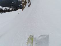
No cracking in 1-2 ft drift East near tree line
-
-
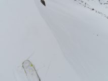
Minor cracking while moving above 12,000′ in top few inches of stiff snow
-

-
New cornice growth, east aspect 12,000′
-
-
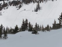
Wet activity from last week’s warmth.
-

-
Wind continuing to transport snow above 12,000′


