Date of Observation: 01/09/2021
Name: Evan Ross
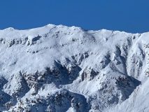
Zone: Southeast Mountains
Location:
Aspect: North East
Elevation: 9,700 to 10,800
Weather: Partly Cloudy, light winds. Funny seeing overcast skys and maybe a couple flakes over Mt CB and clear sky over the Ruby Range. How often does that happen?
Snowpack: The early December weak layer is widespread in the terrain. While slabs above that weak-layer are specific to cross-loaded terrain at lower elevations, or the lee sides of ridge-lines at NTL elevations. Not all terrain features with those common characteristics hold a slab, so you could argue that the slab is isolated in the terrain. Isolated and Stubborn…
We observed one collapse in a flat area. Otherwise no obvious signs of instability. Lots of tracks through all sorts of terrain features in Coneys and previous high traffic area. More ski tracks are also showing up in areas slightly further up valley that get a little less traffic. Still a few features of potential concern, otherwise all those tracks didn’t produce any results.
A few pits on a ENE aspect at ~10,600ft and on a 33-degree slope. Produced: SC fracture results on small column CT tests, and ECTN results on larger column tests, failing on 12/10. This location was sheltered from the wind and held a faceting 4F- slab over the early December facets.