Anthracite Mesa-Coneys

CB Avalanche Center2020-21 Observations

Date of Observation: 01/30/2021
Name: Andrew Breibart


Zone: Southeast Mountains
Location: Coneys
Aspect: North East, East, South East
Elevation: BTL


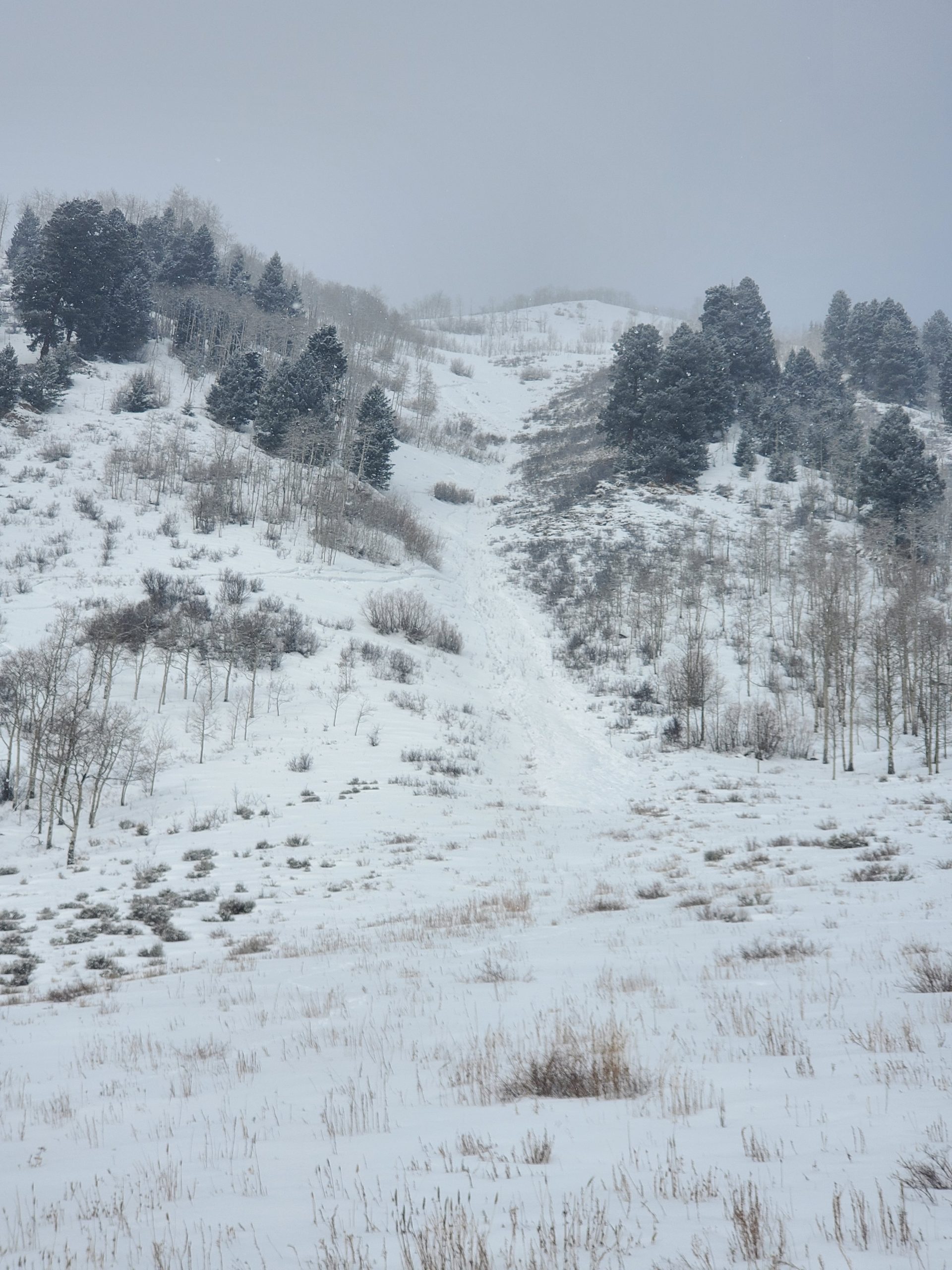
Avalanches: Observed three wet loose slides on the west facing gullies of Gothic. Not much snow was entrained and starting zones were partially exposed cliff bands. I assume these ran between Thursday or Friday (1/28/21-1/29/21).
Weather: Paradise Divide and mountains in the NW zone west of the Anthracites were under obscured skies. In area of observations, mostly cloudy skies with periodic afternoon S-1 and S1 snow. lLight winds in the valley bottom with no snow transport and moderate winds at the ridge lines. Snow and wind didn’t result in additional loading of the bowls. Exception is summit ridge line had minimal snow loading just below ridge.
Snowpack: Traveled off skin track in open areas as much as one can in this area. No cracking or collapsing off the skin tracks. Hand and ski pole probing of the skin track cuts revealed a 1F sun crust on the SE aspect (1/19 interface?). It was about one inch thick about 6 to 8 inches below the surface Ski pen off skin track ranged between 6 and 12 inches. Stomped a wind lip on the ridgeline and stomped around the summit rollover. Nothing cracked, collapsed, or moved. Trace of new snow today from S1 snowfall.


AMR

CB Avalanche Center2020-21 Observations

Date of Observation: 01/30/2021
Name: Sasha Legere

Zone: Northwest Mountains
Location: Anthracites

Avalanches: See photo


Photos:

[/gravityforms]

Walrod

CB Avalanche Center2020-21 Observations

Date of Observation: 01/30/2021
Name: Daniel K

Zone: Southeast Mountains
Location: Walrod gulch
Aspect: East
Elevation: 9400

Avalanches: Noticed a small skier triggered slide in the path just past the walrod connector that looks like it went yesterday. Couldnt really distinguish a crown with the ski tracks and low vis and could’ve been a point release entraining snow in the gully. Not enough snow to go all the way to the road.


Photos:

Anthracite Mesa

CB Avalanche Center2020-21 Observations

Date of Observation: 01/29/2021
Name: Ben Pritchett

Zone: Southeast Mountains
Location: Long Lake area
Aspect: North, North East, North West
Elevation: 9500-10000

Avalanches: No new slab avalanches seen. Dry loose sluffing in steep northerly facing terrain that has grown completely faceted.
Weather: Ridgeline Wind Speed: 20-30 mph
Ridgeline Wind Direction: SW
Wind Loading: Light
Temperature: 35 F
Depth of New Snow: 1 cm
Depth of Total Snow: 85 cm
Weather Description: Cloudy, warm. Pre-frontal winds picked up and began to transport snow early afternoon.
Snowpack: Went hunting for weak snow. Dug numerous holes in this transitional zone on the periphery of the deep snow belt. This area is often representative of weaker parts of the zone, but not as shallow as Spring Creek or Taylor. Height of snow varied from 40-120cm. No collapsing or cracking observed today while traveling in areas of weak snow. Add another 20-30 cm of slab (in the deeper snowpack areas or at higher elevations) and I would expect isolated / stubborn collapsing and the potential for human-triggered avalanches if you find just the right spot. South and west facing slopes have durable, supportive crusts below the most recent storm snow. No current avalanche problem, and not likely to become dangerous with this incoming storm. Northwest and North are thin, and thoroughly faceted. Very little slab structure. Easy to push loose dry avalanches that gouged to near the ground. Sluffing in the deeper parts of the zone can be expected with more than 6-8″ of new snow. Northeast and east have the thickest slabs. Southeast is the touchiest with the stiffest layers (thin crusts) above recently buried and basal facet layers. Northeast through east to southeast remain the bullseye for Persistent Slab avalanches. With Saturday’s loading these slopes will remain the areas of greatest concern.


Photos:

January snow 2017-2021

CB Avalanche Center2020-21 Observations

Date of Observation: 01/29/2021
Name: Andrew Breibart


Zone: Southeast Mountains
Elevation: BTL

Weather: calm, near and above freezing. partly cloudy
Snowpack: sticky snow with snow clumping on skins.
See attached for snow depth and SWE comparison (2017-2021).


Photos:

Large Remotely Triggered Avalanche

CB Avalanche Center2020-21 Observations

Date of Observation: 01/29/2021

Zone: Northwest Mountains
Location: Purple Ridge
Aspect: East
Elevation: 11,600ft

Avalanches: Remotely triggered a large avalanche from a lower angled slope, connected to a steeper slope. After no signs to instability all day, finally found just the right spot to punch through the slab, into the weak layer, and get a collapse. No shooting cracks in the terrain where the collapse occurred, but within a few seconds the larger bowl started to avalanche. The avalanche ran on the slower side, no powder cloud. It was large in size and propagated widely. This slope has avalanche previously this season. The crown is estimated to have averaged about 40 to 45 cm, while the deepest part of the crown where it broke into a cornice was closer to 110 cm.

Weather: Mostly cloudy to overcast sky. Warm temps. Alpine winds picking up in the afternoon and transporting snow.

Snowpack: No other signs to instability. A few roller balls on steep S and SW aspects at lower elevations.

Watching for the persistent slab to wake up below treeline

CB Avalanche Center2020-21 Observations

Date of Observation: 01/29/2021
Name: Jared Berman and Zach Guy

Zone: Southeast Mountains
Location: Coon Basin / Climax chutes
Aspect: North East, South East
Elevation: 9200′ – 11300′

Avalanches: Nothing new
Weather: Warm temps all day. Snow showers early in the morning before skies opened up and the sun popped out for a while. The afternoon brought cloudy skies again and strong winds above treeline from the southwest with visible plumes off of the high peaks.
Snowpack: Traveling through wind-sheltered terrain near and below the treeline, we found slab structures ranging from 30-40cm on southeast and northeast aspects.

On southeast aspects, slabs from new snow were not as deep averaging about 30-35cm resting on top of a melt-freeze crust that varied in thickness depending on aspect and slope angle. One snowpit dug at 11,000′ on a southeast aspect and 28-degree slope revealed a Fist-4 Finger hard slab resting on top of a thick 4.5cm pencil hard crust. The crust is resting on top of weak facets 1mm in size. This was the only pit we dug that showed propagating results (ECTP21). We also got one collapse on a SE slope where the crust was thinner

On northeast aspects near treeline, the slab was slightly larger ranging from 35-40cm which is resting on top of 60cm of completely faceted snow. Slabs on these colder aspects are also Fist-4 Finger minus in hand hardness. Two test pits did not show propagating results. However, once we added additional load to the slab, extended column tests showed full propagation (see video below). We skied steeper terrain on northeast aspects with no signs of instability, but steered clear of possible crossloaded terrain.

As we moved lower in elevation below treeline on northeast aspects, the slab steadily became softer and softer until we reached 9500′ where snowpack structure is essentially all facets to the ground, with only 15cm of recent snow on top.


Photos: