Snodgrass

CB Avalanche Center2014-15 Observations

LOCATION: Crested Butte Area
DATE OF OBSERVATION: 01/19/2015
NAME: ADB
SUBJECT: Snodgrass
ASPECT:
ELEVATION: BTL/NTL

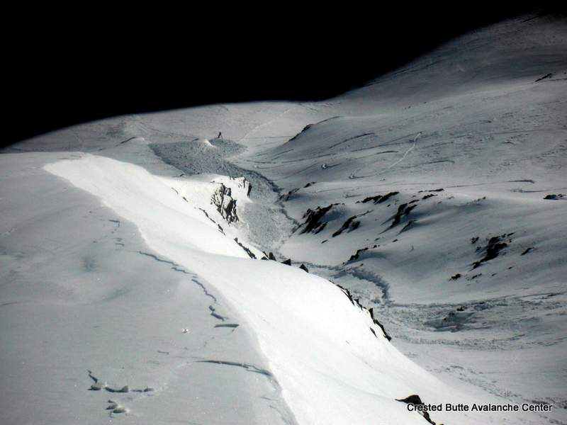
AVALANCHES: On east side of Snodgrass, observed older avalanche debris in a terrain trap and a recent N-LS-R1 on SE aspect (slide may have occurred within last 72 hours).

WEATHER: mostly sunny skies with slight breeze with a gradual transition to mostly cloudy skies to breeze. Breeze didn’t have velocity to transport snow.

SNOWPACK: Southeast aspest along skin track had “crunchy sun crust.

East side of Snodgrass: Hand test below ridge revealed sun crust underlain by facets. This cycle repeated itself for a depth of 16 to 20 cm.
At same elevation band as aspens, snow transitioned to stiff wind slabs to Gothic road.

Slide on Schuylkill Ridge

CB Avalanche Center2014-15 Observations

LOCATION: Paradise Divide Area
DATE OF OBSERVATION: 01/18/2015
SUBJECT: Slide on Schuylkill Ridge
ASPECT: North, South East
ELEVATION: 11,000

AVALANCHES: New snow ran on a SE facing slope. Skier triggered. Began at about 11,000 feet and ended about 10,000 feet.

WEATHER: Clear

Small Slide in Red Lady Bowl

CB Avalanche Center2014-15 Observations

LOCATION: Crested Butte Area
DATE OF OBSERVATION: 01/13/2015
NAME: Kyle Smith
SUBJECT: Small Slide in Red Lady Bowl
ASPECT: South
ELEVATION: 11,000

AVALANCHES: This is probably common knowledge already since I noticed it a few days ago. Skinning up red lady bowl/glades ridge, I observed a small slide on the other side of the bowl (S,SW) around 11,000ft. It looks like there was some skier activity over there, so I imagine it was triggered from a ski cut. Judging from a distance, the slide had about a 60 yard run. Since then, I have not observed any other action on the same aspect. Cheers. Be safe out there.

WEATHER: Blue Bird

UPLOADS:

Red-Lady-Slide

Mountain Weather January 19, 2015

CB Avalanche CenterWeather

Date: 01/19/2015

Colorado seems to be getting the stiff arm in this week’s weather pattern. The jet stream is helping to keep the storm track north of Colorado and is favoring the Northwest, ID and WY. So we’re currently looking to have a mostly dry week ahead. Us forecasters will be working hard to think of witty comments to keep everyone entertained this week. This afternoon and evening could be the exception to the outlook. A weather system will clip Northern Colorado during this time and we may see some light snowfall.

Snodgrass

CB Avalanche Center2014-15 Observations

NAME: JSJ
DATE: 15-01-18
LOCATION: Snodgrass
ELEVATION: 9400′ to 10,600′
ASPECT: NE
WEATHER: Clear and warm with steady light to moderate NNW winds.

SNOWPACK/AVALANCHE OBS: Surface faceting continuing on shaded aspects and some thin wind crusts found below treeline on open slopes crossloading terrain features North to South. Persistent slab seems to be losing cohesion. Travel on open slopes into the high 30’s slope angle produced one small collapse on a steep roll, but nothing moved and no other signs of instability. Ski pen deepening throughout the week it seems. Poor structure in this zone but low hazard it seems due to any slab cohesion.