CBPSP Control Results (CBMR)

CB Avalanche Center2015-16 Observations

Location: Crested Butte Area
Date of Observation: 12/27/2015
Name: Chad Berardo
Subject:
Aspect: North East
Elevation: 11,300′ – 11,550′

Avalanches: SS-AE-R2-D2-O/G – Peach Pit (right, NE)
SS-AE-R2-D2-O/G – Wolf’s Lair (left, NE)
SS-AE-R1-D1-O – Jack in the Box Glades.
SS-AE-R1-D1-O/G – Wolf’s Lair (south exit, SE)
Weather: Cold, light winds, mostly clear.
Snowpack: 11,600′-11,900′ – 10-15 cm cracking in upper, new snow layers w/ thrown 2# hand charges through Main Street, Coffey Grounds, and Fran’s Blend.

11,550′ – Peach Pit, 4# air-blast triggered SS-AE-R2-D2-O/G with propagation through potential ‘safe zone.’ Ski-cutting of this path before recent storm cycle had produced R1-D1 failures. (IMG_7182)

Jack in the Box Glades – observed storm cycle, natural activity (full track) in area flanked by on both sides by previous explosive testing. 2# hand charges resulted in SS-AE-R1-D1-O. Generally soft and un-cohesive new snow on weak, faceted grains in this zone.

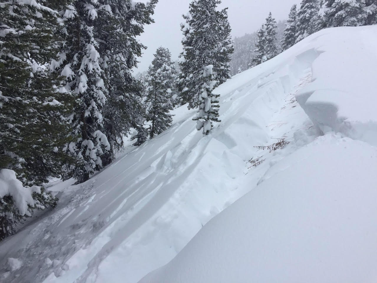
11,300′ – Wolf’s Lair (left, NE) Last 2# shot of 1st pass produced SS-AE-R2-D2-O/G (IMG_7189). Chose different egress. Subsequent shots on 2nd pass resulted in similar R1/R2-D1/D2 failures on NE – SE aspects. (IMG_7197-(SE), IMG_7198-(NE). “Tender” Extensive collapsing and cracking with travel throughout this zone.

IMG_7198
20151227CBSPAvalanche
IMG_7189
IMG_7182

Red Coon

CB Avalanche Center2015-16 Observations

Location: Crested Butte Area
Date of Observation: 12/27/2015
Name: Evan Ross
Subject: Red Coon
Aspect: South East
Elevation: 9,200-12,000

Weather: Wind was generally calm with a light breeze at times. Clear sky. Temps felt like they where in the upper 20’s but didn’t measure.
Snowpack: Last weeks storm snow continues to settle and set up. Ski pen was about 30cm across all slopes traveled. At 11,200ft, SE, 28 slope, boot pen was 50cm, old storm snow 60cm and HS 75cm. Collapsing is becoming more stubborn. Either from lots of jumping or when folks take their skis off and wallow around. Still observed numerous large collapse throughout the day.

Slopes near 30 degrees had a thin zipper crust in places by afternoon.

Avalanches: Another old avalanche from last weeks cycle that didn’t seem to be previously reported In Wolverine. R1D2

IMG_1100

Pittsburg Trees

CB Avalanche Center2015-16 Observations

Location: Paradise Divide Area
Date of Observation: 12/27/2015
Name: Erika Vohman
Subject: North Facing low angle trees
Aspect: North
Elevation: 10,000

Avalanches: there was a lot of evidence of steeper angle pitches having slid before this last storm. no new avalanches were observed.
Weather: Bluebird
Snowpack: About 15 inches of fresh cold powder on top of unconsolidated powder from previous storm. Lots of whoomphing.

Ohio Pass Avalanche

CB Avalanche Center2015-16 Observations

Location: Kebler Pass Area
Date of Observation: 12/24/2015
Name: Brian Aslum/Snotrackers
Subject: Ohio Pass Avalanche
Aspect:
Elevation:

Avalanches:
Weather:
Snowpack:

20151224_OhioPassslide_PCBrianAslum

Mountain Weather

CB Avalanche CenterWeather

Date: 12/27/2015

We will start out with bitterly cold temperatures this morning in the valleys and slightly warmer temperatures above 10,000 feet. Light easterly winds at ridge top in the morning will ease and become more light and variable as a strengthening dome of high pressure builds into the region. A small chance of snow Monday and Tuesday at higher elevations, but the system is moisture starved. Question now becomes how strong the high pressure will become and how long the high pressure will last…

White Mountain Obs

CB Avalanche Center2015-16 Observations

Location: Crested Butte Area
Date of Observation: 12/26/2015
Name: Ian Havlick
Subject: White Mountain Obs
Aspect: South, South West, West
Elevation: 9000-12000

Avalanches: Evidence of avalanches, but generally snowed and drifted in. Avalanche cycle was widespread, and if wind loading continues could see another round of avalanches. We quite worried about remote triggering potential all day, and didnt travel in terrain much steeper than 28º all day.
Weather: Clear skies, cold temps (12ºF), strong radiation and SE-E-NE-N winds in the progession as the day went on.
Snowpack: Thunderous collapses constantly all day, some violent and rattling twigs of snow. 8-10″ settlement cones, active light the moderate snow transport from the E-NE. Shooting cracks ~50ft, but rumbling collapses went much further. 2, ECT tests produced propagating results from 17 and 22 taps, sudden collapse

IMG_2823-1

Collapsing on Mt. Emmons

CB Avalanche Center2015-16 Observations

Location: Crested Butte Area
Date of Observation: 12/26/2015
Name: Zach Guy
Subject: Collapsing on Mt. Emmons
Aspect:
Elevation: 9,000 -11,500 ft

Avalanches: Nothing new that hasn’t been reported, except a skier triggered slide on the hill above the Nordic Center. See photo
Weather: Clear to few skies. Cold temps, Light to moderate NE winds with light transport off of high peaks.
Snowpack: Rumbling collapses when I would jump on the snowpack after getting away from the skin track.

Snodgrass ob

CB Avalanche Center2015-16 Observations

Location: Crested Butte Area
Date of Observation: 12/25/2015
Name: Johnny Biggers
Subject: Snodgrass ob
Aspect:
Elevation: Below treeline

Avalanches: See photo. Remotely triggered this slope while skiing on flat road. Downhill side of the Snodgrass road near “panorama point”.
Weather:
Snowpack:

unnamed-1

Mountain Weather 12/26/15

CB Avalanche CenterWeather

Date: 12/26/2015

The tail end of yesterday’s storm fizzled, bringing only a few inches of snow to our zone. Temperatures across our mountains are all subzero this morning under light northerly winds. Its -16*F in town. Brrr. Pack an extra puffy today: we’ll warm to single digits in the mountains. The trough that brought us a white Christmas has split, with a closed low in development over Southern Arizona. This leaves us out of the storm track and away from strong gradient flow over the next few days. This equates to dry weather and temperatures plunging below seasonal norms through the weekend.

Collapsing/slide on Snodgrass

CB Avalanche Center2015-16 Observations

Location: Crested Butte Area
Date of Observation: 12/25/2015
Name: Zach Guy
Subject: Collapsing/slide on Snodgrass
Aspect: North East, East
Elevation: Below treeline

Avalanches: The only piece of avalanche terrain that we came across had slid naturally. NE aspect below treeline that ran before last night’s snowfall. 2-3 feet deep, on basal facet layer. SS-N-R2-D2-O. Partial clearing in the p.m. revealed what looked like several new slides near Red Ridge/ White Rock area, coming off of SW or S aspects above treeline. Debris piles were ~D2 in size, crowns obscured by clouds.
Weather: Light snowfall, with a couple of inches of accumulation by mid day. Winds began increasing around noon, with moderate gusts and blowing snow below treeline. Overcast skies began clearing to broken later in the day.
Snowpack: ~6″ of new snow overnight. Persistent slab was noticeably denser from settlement compared to my tour 12/23 on Anthracite Mesa, more supportive on skis, 5-10″ settlement cones. Collapses were fewer in frequency, but louder and longer running. SCARY. Often it would take jumping on the snowpack to initiate collapses, whereas 2 days ago they were going while simply ski touring. Structure was consistent across all terrain, about 30″ of slab, increasing in hardness with depth, over hollow facets.