Whumphing on low angles of Paradise Divide Bowl

CB Avalanche Center2017-18 Observations

Location: Paradise Divide Area
Date of Observation: 11/04/2017
Name: Turner Petersen CBCS Senior
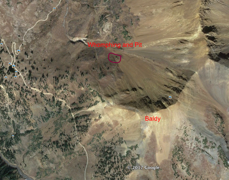
Subject: Whumphing on low angles of Paridise Divide Bowl (WSC bowl)
Aspect: North West
Elevation: 11,600

Avalanches: None, Just whumphing on a 30 degree protected pocket.
Weather: Cloudy and snowy with winds blowing 10-15 mph to the North West with gusts in the 30’s. Maybe 28 degrees F.
Snowpack: Snow depth in a wind-loaded gully ranged from 35-75 cm deep. The protected bottom of the very small north facing gully contained most of the snow we saw in October and that’s where we were seeing positive results with our collum test. The nonprotected section of the pit outside of the gully was mostly this week’s new snow. There were almost 7 inches of new snow some of which was from wind loading blowing across the gully.

We remote triggered cracking from 15 meters away at the top of a very small convex roll from the bottom where we were skinning. A big whumph occurred so we decided to dig a pit and do a collum test. Surrounded by grass and on a small pitch of about 30 degrees at the very bottom of Paradise Bowl (Paradise Divide Bowl), we felt good about where we were. The test produced a positive result at 11 taps about a foot into the snowpack. The slab was failing on that mid-October storm layer. it just took a little weight to wake it up. Extremely rotten facets are littering the snowpack right now.

Snowpack
Location
Crack

Good Spring Conditions

CB Avalanche Center2016-17 Observations

Location: Kebler Pass Area
Date of Observation: 04/15/2017
Name: Evan Ross
Subject: Good Spring Conditions
Aspect: South
Elevation: 10,800-12,600

Avalanches: Some very small and slow running loose wet avalanches on slopes over 40 degrees in steepness.
Weather: Big and blue. Light westerly winds at ridgeline.
Snowpack: At 12,500ft the upper snowpack was made up of several crusts merged together to form last nights freeze down to 25cms. Percolation Columns extended below this depth into 4F- melt forms to an observed depth of 40cms.

Boot pen was about 10 to 15cms at 11am with some punching through the upper crust. Current high temperatures and solar gain plus light alpine winds didn’t allow snow surfaces to weaken beyond this at upper elevations. While lower elevations traveled, were much further along in the spring transition and stayed supportable through the end of our day at 2pm.

Mountain Weather 4/14/2017

CB Avalanche CenterWeather

Date: 04/14/2017

Clear sky Thursday night allowed for snow surfaces to freeze while valley temperatures dropped into the upper 20’s and 11,000ft temperatures to drop to right near freezing. High temperatures Friday should be should a couple degrees cooler then yesterday with another small decrees on Saturday. A low pressure trough will be moving by north of Colorado during this time period. This passing trough has brought increased gusty winds to the alpine for Friday morning into midday. By Sunday night into Monday, another passing trough looks to sag a little further south and at this point only looks to bring some increased clouds. There are a few chances for a change in weather looking out to next week, but currently nothing to promising. May be time to start shoveling your snowbanks into the melted out portions of your yard to start watering.

Mountain Weather 4/12/2017

CB Avalanche CenterWeather

Date: 04/12/2017

Its never a good sign for winter weather in the near future when weather discussions are talking about the fire conditions. Dry and warm as far as the eye can see could be the end of this weather discussion. Well, ok a few more points can be made. Cloud cover is decreasing this morning as we are back in warm and dry southwest flow. The pressure gradients will tighten tomorrow and we’ll see an uptick in gusty alpine winds with hight temperatures a couple degrees warmer then today. Winds looks to ease again by the weekend with high temperatures dropping a couple degrees. It all comes back to warm and dry weather into the extended forecast with a few blips of increased clouds maybe this weekend or next week.

Minimal Avalanche Issues

CB Avalanche Center2016-17 Observations

Location: Paradise Divide Area
Date of Observation: 04/11/2017
Name: Evan Ross
Subject: Minimal Avalanche Issues
Aspect: North East, East, South East
Elevation: 11,600-12,950

Avalanches: Plenty of old loose wet avalanches to be viewed. Mostly D1.5 or smaller in size at near and above treeline elevations on northeast to south to west aspects. All this activity looks to have happened previous to last weekend. Very little activity to be viewed below treeline.
Weather: Clear sky in the morning increased through the day becoming overcast by 2pm. Mostly calm to light winds at ridgeline.
Snowpack: Minimal avalanche issues observed. Didn’t encounter a loose wet concern. Isolated wind drifts up to 20cm’s deep were mostly unreactive.

Northeast: The northerly end of the aspect spectrum is staying dry, while the easterly end of the spectrum was warmed and produced some loose wet activity last Friday 4/7. These snow surfaces stayed dry today and sluffing was minimal. Last weekend storm snow was drifted to 20cm’s thick right near ridgeline with some stubborn cracking to 10ft, but no other results.

Southeast: Below 11,500ft the upper snowpack has made a nice transition to spring conditions and typical corn cycle setup. Above that elevation is still transitional. Boot pen is about 15cm-20cms deep breaking through the surface crust while frozen in the morning. Some portions of the slope are cross loaded to 20cms deep by last weekends storm with a ski supportable surface crust on top. While other portions of the slope are tinted brown, and blown down to the 4/7 interface. The 4/7 interface was also breakable to boots into colder snow below while supportable to skis. This surfaces warmed up in the afternoon with 5cm or so ski pen.

East 11,800-12,200: Hot, but not a mess. I don’t know if I like hot messes, but I know I don’t like just hot all-a-cart. Sweaty. Mostly traveled near ridgeline where last weekends new snow was baked in, and non problematic. Moist snow surfaces but no loose wet concerns.

Mountain Weather 4/10/2017

CB Avalanche CenterWeather

Date: 04/10/2017

Its going to be like Groundhog Day all week. Only each day your going to get hotter and more sweaty. The sun will come up each day, (feel like I will nail that part of the forecast), the temperatures will rise, westerly winds will be light to moderate, the sun will go down and boom! We’ll do it all over again the next day.

A blip in the westerly flow may bring some increased clouds late Tuesday into Wednesday. Then southwest flow will allow high temperatures to ramp up even more on Thursday and Friday. Settle in folks, its going to be a nice dry week ahead.

Mountain Weather 4/9/2017

CB Avalanche CenterWeather

Date: 04/09/2017

Well, at least last night’s storm brought the wind… and there’s cold air on the way.

A windy trough of low pressure is blowing across the western US this morning, with the substantial moisture tracking far away in the Northern Rockies. This morning as the trough axis passes overhead a cold front will drop temperatures several degrees and shift winds to the Northwest. For the last day of the ski area, expect a cool breezy day, with clouds decreasing as the day goes on. The winds look to calm down as the lifts stop spinning.

For those partaking in the traditional closing day rituals, you might consider bringing a wind-proof sock.

Mountain Weather 4/8/2017

CB Avalanche CenterWeather

Date: 04/08/2017

Last night was downright balmy with overnight freezing levels near 12,000ft and partly cloudy sky. We could see a couple hours of sun this morning poking through partly cloudy sky, then clouds will thicken through they day. I’d expect some more green housing through the clouds creating a warm feel, and high temperatures near or just below yesterdays. Southwest winds will remain strong and gusty as the pressure gradient tightens ahead of a low presser trough to our northwest. Moister associated with this flow may bring some high level showers today that will mostly evaporate before anything hits the ground. Temperatures should begin cooling tonight ahead of an arriving cold front as moister wrapping around the foot of the low pressure trough increases to our north. We should see a few inches of new snow overnight but the main event will be to our north. Sunday looks to remain overcast and breezy with a drying trend starting in the afternoon. Next week will remain dry with the next small disturbance looking to be around Wednesday.

Loose Wet Moving To Northerly Slopes

CB Avalanche Center2016-17 Observations

Location: Paradise Divide Area
Date of Observation: 04/07/2017
Name: Evan Ross, Than (President) Acuff
Subject: Loose Wet Moving To Northerly Slopes
Aspect: North East
Elevation: 9,500-11,500

Avalanches: Skier triggered several small loose wet avalanches on northeasterly slopes from above treeline to below treeline elevations.

Plenty of loose wet activity to be viewed, from over the last couple days, on easterly aspects. Now extending into northeasterly aspects today with roller balls on some northerly slopes.
Weather: Increasing clouds becoming overcast in the afternoon. These clouds helped trap incoming solar radiation and produce a green housing effect. Gusty moderate winds at ridgeline.
Snowpack: Wet avalanche problem encroaching on northerly aspects. True north still staying dry, but anything with a slight easterly tilt was in the cold to moist transition on the snow surface.

Occasional snow plumes off some high peaks, but nothing that looked to be loading lee slopes.

Skier triggered small loose wet avalanches on northeasterly NTL slope overlapping some older natural loose wet avalanches from a more easterly tilted slope.

Mountain Weather 4/7/2017

CB Avalanche CenterWeather

Date: 04/07/2017

A band of high thin clouds passed through last night while temperatures in the 10-12k elevation range stayed near freezing with below freezing temperatures in the valleys. Winds are on the increase from the southwest as a low pressure system system is spinning moister into the western US. This change to southwest flow has opened the door for increasing temperatures into Saturday. With an increase in temperatures today, we should also see increasing cloud cover this afternoon. A bank of clouds is currently stalled out over western Utah and they should start moving into Colorado today. As this low pressure system moves north of Colorado on Saturday/Saturday night, its looking like we could get a few inches of snow accumulation. Then dryer weather will begin moving back in on Sunday.

Since we have been wrong on the last few spring storms, forecasting new snow and then getting skunked, I hope I’m wrong on this one and it just dumps for closing day at CBMR! With rain in Gunnison of course, so that the trails melt out.