

Location: Paradise Divide Area
Date of Observation: 11/23/2019
Name: Evan Ross
Subject: Couple Old Natural Avalanches And Some Good Turns
Aspect: North, South, West
Elevation: 11,000-12,300ft
Avalanches: A few persistent slabs ran naturally on NE aspects during the 11/22 storm. One of these was large in size and could have buried a person. The others were smaller but dragged through plenty of rocks and trees.
Schuylkill Ridge, NE aspect at about 11,350ft. SS-N-R1-D2-O, SS-N-R1-D1.5-O
The NE facing Shield at 12,000ft on Scarps Ridge may also have had a slab avalanche or at least just some sluffing but I didn’t get a good view.
Weather: Beautiful sunny and clear day. The nearby Cinnamon Weather Station at 12,293 reordered North winds in the 5 to 10mph range. and a high temperature of 25F at that elevation.
Snowpack: The last round of northwest to north winds on 11/22 had previously transported much of the recent new snow on wind-exposed terrain features at both above and near treeline elevations. More protected terrain features had some wind stiffened snow on the surface or no wind effect at all.
The 11/22 storm dropped about 5-6″ of low-density new snow. The couple inches of new snow from the 11/21 storm felt like it had some moisture pulled out of it and had lost some of its soft slab feel compared to my observation on 11/21. No signs of instability were observed despite the very weak 11/20 interface we were traveling on. Maybe this was due to some of the moisture being pulled out of the 11/21 storm and a general soft over soft snowpack structure, or maybe the unstable pocket just wasn’t encountered. The public was also out in force getting some good turns on Northerly and Westerly facing terrain at near and above treeline elevations. From social media pictures, it doesn’t currently appear that anyone found any significant signs to current instability.
The new snow that has accumulated on southerly facing slopes was thick and moist by Saturday afternoon. This snow will probably melt on some slopes by Monday or form crusts down the ground or the 11/20 melt-freeze crust.
While we may not have seen signs of instability today, the snowpack is ripe for unstable conditions once we start seeing a load applied or slabs forming. As noted in previous observations, the 11/20 interface is particularly weak where it was protected from past wind events and the sun. This weak interface can be found on shaded terrain features and/or NW to N to E aspects. Northerly to Easterly aspects above 11,300ft are probably the best bullseye.
Photos:
-
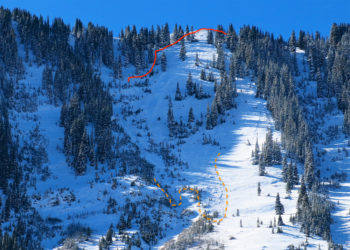
- Schuylkill Ridge, NE aspect at about 11,350ft. Large natural avalanche that ran on 11/22.

-

- Schuylkill Ridge, NE aspect at about 11,350ft. SS-N-R1-D1.5-O

-
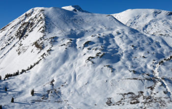
- Cinnamon MT East Face. Right to left wind effect.

-

- Purple Palace Area. Wind textured snow surface on the NE facing slope at about 10,300ft.

-

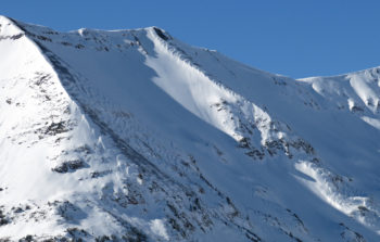
- Purple Palace Area. East to North East facing paths with start zones near 11,000ft. Some right to left down valley wind-loading.

-
- Purple Ridge above the Slate River. NE facing bowls at about 12,000ft with the previous winds mostly blowing up the slope but also some cross-loading.


