Unstable snowpack were you can find old October snow.

CB Avalanche Center2017-18 Observations

Location: Paradise Divide Area
Date of Observation: 11/19/2017
Name: Evan Ross
Subject: Unstable snowpack were you can find old October snow.
Aspect: North East, East, South
Elevation: 9,700-12,300

Weather: Few Clouds, light west winds at Ridgeline.
Snowpack: A potentially unstable snowpack where old October snow was found at the bottom of the snowpack, and stable, supportive skiing on slopes that were dry before 11/17/2017.

On south and east slopes traveled. HS was in the 30-60cm range with only the 11/17 snow on the ground. No sings of instability. Ski pen around 5-10cm. Southerly slopes warmed with a soft crust in the afternoon.

On a northeast slope the snowpack structure looked poor. With the 11/17 storm snow sitting on faceted older snow. Depending on the aspect tilt, some of the those facets were capped by 1-3cm crust. The 11/17 slab had lots of Graupel mixed in, leaving the slab to look a little less cohesive then observed in other locations.

Belview.002
Belview.001

Unstable snowpack where you can find old October snow.

CB Avalanche Center2017-18 Observations

Location: Paradise Divide Area
Date of Observation: 11/19/2017
Name: Evan Ross
Subject: Unstable snowpack were you can find old October snow.
Aspect: North East, East, South
Elevation: 9,700-12,300

Weather: Few Clouds, light west winds at Ridgeline.
Snowpack: A potentially unstable snowpack where old October snow was found at the bottom of the snowpack, and stable, supportive skiing on slopes that were dry before 11/17/2017.

On south and east slopes traveled. HS was in the 30-60cm range with only the 11/17 snow on the ground. No sings of instability. Ski pen around 5-10cm. Southerly slopes warmed with a soft crust in the afternoon.

On a northeast slope the snowpack structure looked poor. With the 11/17 storm snow sitting on faceted older snow. Depending on the aspect tilt, some of the those facets were capped by 1-3cm crust. The 11/17 slab had lots of Graupel mixed in, leaving the slab to look a little less cohesive then observed in other locations.

Belview.002
Belview.001

Soft Slab avalanche on Baldy 11/18/17

CB Avalanche Center2017-18 Observations

Location: Paradise Divide Area
Date of Observation: 11/18/2017
Name: Stuart Griffin
Subject: Soft Slab avalanche on Baldy 11/18/17
Aspect: North
Elevation: ~11,000′

Avalanches:

SS-ASr-R2-D2-O
Remotely triggered from about 125′ away. Slide was about 50′ wide, ran approximately 150′. Crown size ranged from 1- 3 1/2′. Observed two other sympathetic slides. One of which was above original slide, unsure of distance run, but crown height appeared to be > 4′. Second observed slide was smaller in size, roughly 20′ wide with a 1-2′ crown height.

All of the above mentioned slides were all in wind loaded areas. Western side of northerly aspect.
Weather: Clear skies, N wind 10-15mph, Temp ~32*F
Snowpack: Unconsolidated with little to no base. Poor bonding between new snow and old snow. Basal Facets present on all aspects, also observed a lot of graupel mixed in with new snow. Lots of whumpfing, shooting cracks, very touchy snowpack.

IMG_4647
IMG_4646
IMG_4645

Gothic

CB Avalanche Center2017-18 Observations

Strange weather ending with a decent thunderstorm last night.  VERY dense snow averaging 13% water, though much of the storm it was at 16% with a total of 10½” new and water of  1.38″.  Strong overnight wind added to the overall fun.  Currently though calm and clear with 10″ of snow on the ground and the winter’s low at 4ºF.  billy

Old snow coverage before Nov 17 storm

CB Avalanche Center2017-18 Observations

Location: Paradise Divide area
Date of Observation: 11/15/2017
Name: Ben Pritchett & Eric Murrow
Subject: Old snow coverage
Drive through Kebler, Slate River Valley, Paradise Divide, Washington Gulch, Gothic Valley, around Crested Butte, and Cement Creek.


Thin and Isolated

CB Avalanche Center2017-18 Observations

Location: Paradise Divide Area
Date of Observation: 11/07/2017
Name: Evan Ross
Subject: Thin and Isolated
Aspect: West, North West
Elevation: 10,700-12,300

Avalanches:
Weather: Partly cloudy sky and generally calm winds with moderate gusts from the southwest. Enough solar to warm snow surfaces in low angled terrain and southerly facing slopes, mostly below 11,000ft.
Snowpack: Just a dusting of new snow from recent days. So, little change to the slowly developing snowpack. Thin and isolated would be my best short answer description of the current snowpack. Generally thin snow cover with isolated avalanche potential on wind loaded terrain. Snowpack structure is highly variable through the terrain. From bare ground or very thin snow coverage on southerly slopes, wind scoured on many south westerly to westerly slopes, to just a thin snowpack on the other aspects. There is very little to no snow on all aspects below 10,500ft. The deepest snowpack could mostly be found on northwesterly to north facing slopes above treeline that are either protected from the wind or have seen additional wind loading during previous storms. Faceted snow from October is the weak layer at the bottom of the snowpack and can be found where it hasn’t been blown away or previously melted by the sun. Find a thick enough slab on top of this week snow and you’ll have found a potential avalanche problem. These two ingredients looked to mainly line up on wind loaded terrain. Such as, cross loaded gullies on westerly aspects or wind loaded pockets on northerly and easterly aspects.


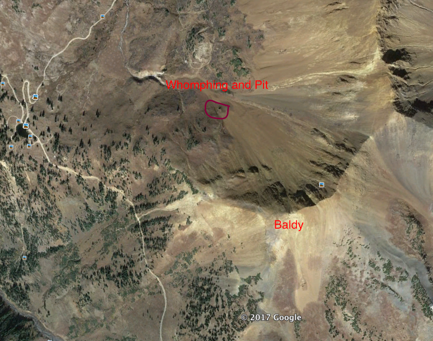
Northwest facing bowl on Mt Baldy. Westerly facing slopes completely blown off with northeasterly have more continuous snow coverage and wind loading.


WSC Bowl? Westerly facing bowl near Paradise Divide on Mt Baldy. The deepest and most suspect looking snow coverage was in this area on north to northeast aspects of this bowl.


Looking up Rock Creek past Cinnamon Mountain and toward Treasury Mountain.


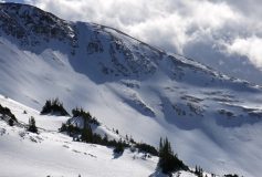
October snow is faceted and week at the bottom of the snowpack. Add enough snow on top of these facets and you will have found the lone avalanche problem. North to northeast aspects were the most suspect with current snow coverage.


Looking at northeasterly to east facing slopes on Purple Ridge.


View from Paradise Divide toward Mt Richmond.

Shallow Slab Avalanche on Mt. Baldy

CB Avalanche Center2017-18 Observations

Location: Paradise Divide Area
Date of Observation: 11/06/2017
Name: Anonymous
Subject: Shallow Slab Avalanche on Mt. Baldy
Aspect: North West
Elevation: 11,400

Avalanches: At 1:45 PM I triggered a shallow but wide (70m+) slab avalanche while skiing alone on the NW aspect of Mt. Baldy. I was alone because I was really just out for a tour on the roads. But I had bootpacked up to Baldy’s West ridge for the exercise, in very shallow snow/talus, and I was planning to sideslip back down a trough and then do a descending traverse back to the road. As I traversed out of the trough onto an open slope of about 25 degrees, I heard the snow wumph then immediately saw cracks form above and all around me. Before I could do anything, a wide swath of the slope cut loose and slid, with me approximately in the middle. I was still on my feet, so I skied with it, heading down but slightly across it for about 20 meters before I reached stable snow. Luckily the slide was relatively slow and shallow (4-6″), with no trees, rocks, or obstacles in its path. It slid for about 50-60 meters before stopping.
Weather: strong, gusty winds from the southwest, blowing snow, occasional snow showers
Snowpack: 6-10″ windblown surface with some softer snow in troughs

Baldy-Avalanche-Far
Baldy-Avalanche-Close

Whumphing on low angles of Paradise Divide Bowl

CB Avalanche Center2017-18 Observations

Location: Paradise Divide Area
Date of Observation: 11/04/2017
Name: Turner Petersen CBCS Senior
Subject: Whumphing on low angles of Paridise Divide Bowl (WSC bowl)
Aspect: North West
Elevation: 11,600

Avalanches: None, Just whumphing on a 30 degree protected pocket.
Weather: Cloudy and snowy with winds blowing 10-15 mph to the North West with gusts in the 30’s. Maybe 28 degrees F.
Snowpack: Snow depth in a wind-loaded gully ranged from 35-75 cm deep. The protected bottom of the very small north facing gully contained most of the snow we saw in October and that’s where we were seeing positive results with our collum test. The nonprotected section of the pit outside of the gully was mostly this week’s new snow. There were almost 7 inches of new snow some of which was from wind loading blowing across the gully.

We remote triggered cracking from 15 meters away at the top of a very small convex roll from the bottom where we were skinning. A big whumph occurred so we decided to dig a pit and do a collum test. Surrounded by grass and on a small pitch of about 30 degrees at the very bottom of Paradise Bowl (Paradise Divide Bowl), we felt good about where we were. The test produced a positive result at 11 taps about a foot into the snowpack. The slab was failing on that mid-October storm layer. it just took a little weight to wake it up. Extremely rotten facets are littering the snowpack right now.

Snowpack
Location
Crack